


Sunday Morning Forecast with Meteorologist Lena Maria Arango
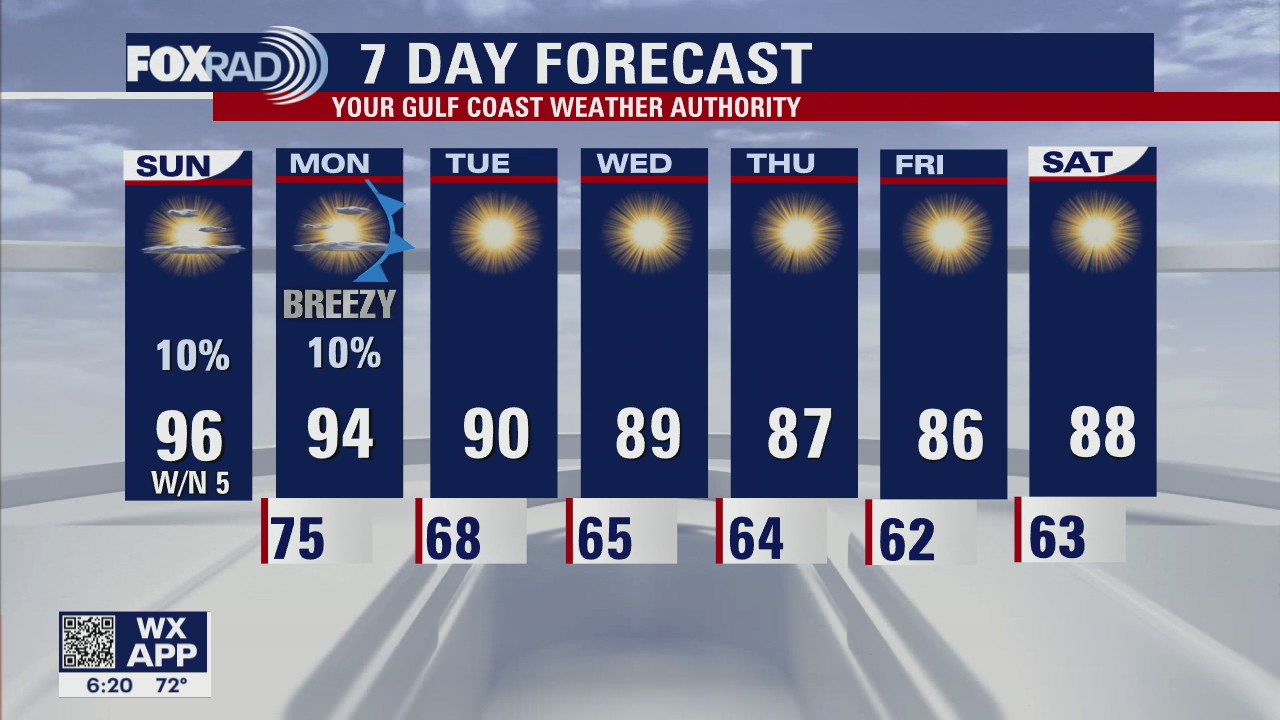
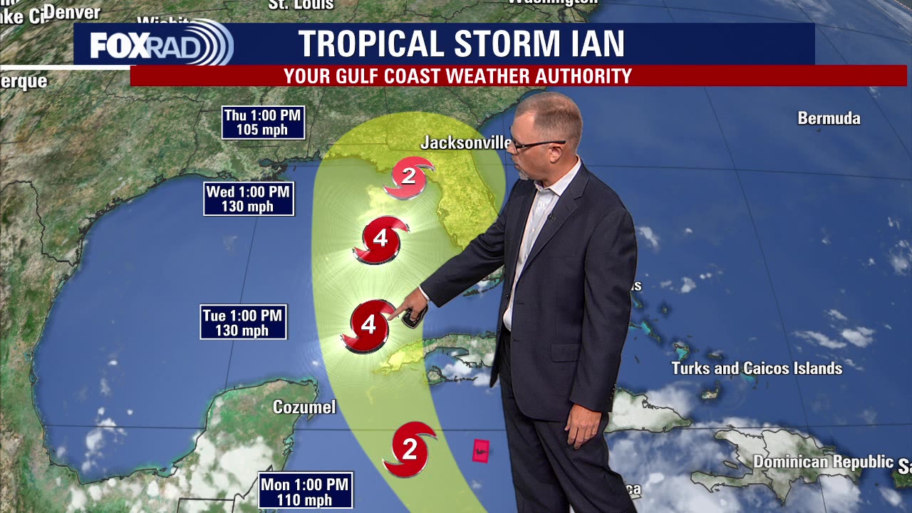
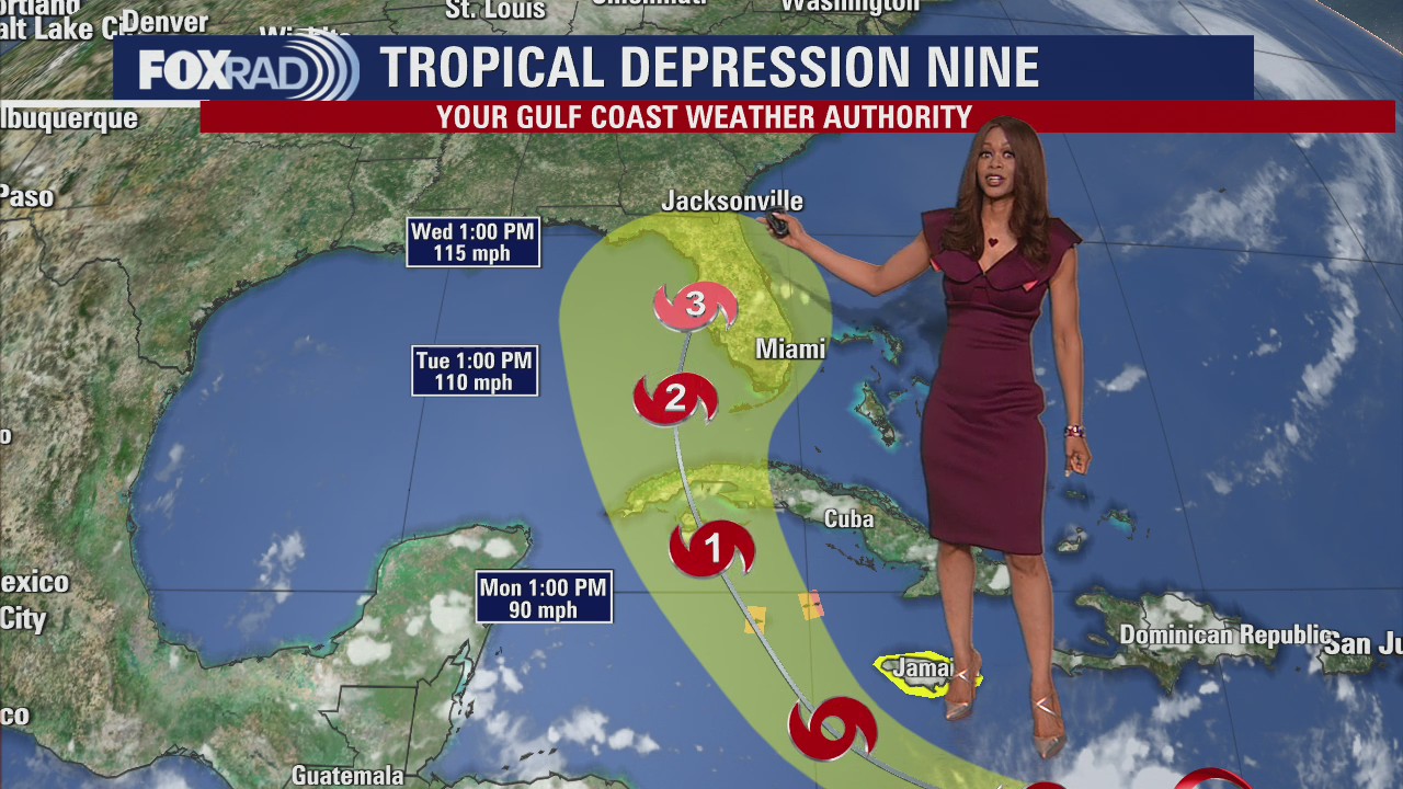
One last warm day, and then tomorrow the transition begins. Plan for a bit of a breeze as the front works its way through our area on Monday, though rain chances are looking minimal at best. Come Tuesday, a blissful less humid weather pattern sets in for the remainder of the week. Our highs will be near average, and our morning lows will actually be slightly below! In the tropics, Ian is set to rapidly intensify today eventually becoming a major hurricane before impacting Florida midweek. There are no concerns for Texas, and things in the rest of the Atlantic basin continue to fizzle out.
One last warm day, and then tomorrow the transition begins. Plan for a bit of a breeze as the front works its way through our area on Monday, though rain chances are looking minimal at best. Come Tuesday, a blissful less humid weather pattern sets in for the remainder of the week. Our highs will be near average, and our morning lows will actually be slightly below! In the tropics, Ian is set to rapidly intensify today eventually becoming a major hurricane before impacting Florida midweek. There are no concerns for Texas, and things in the rest of the Atlantic basin continue to fizzle out.

Saturday night leading into Sunday morning weather forecast
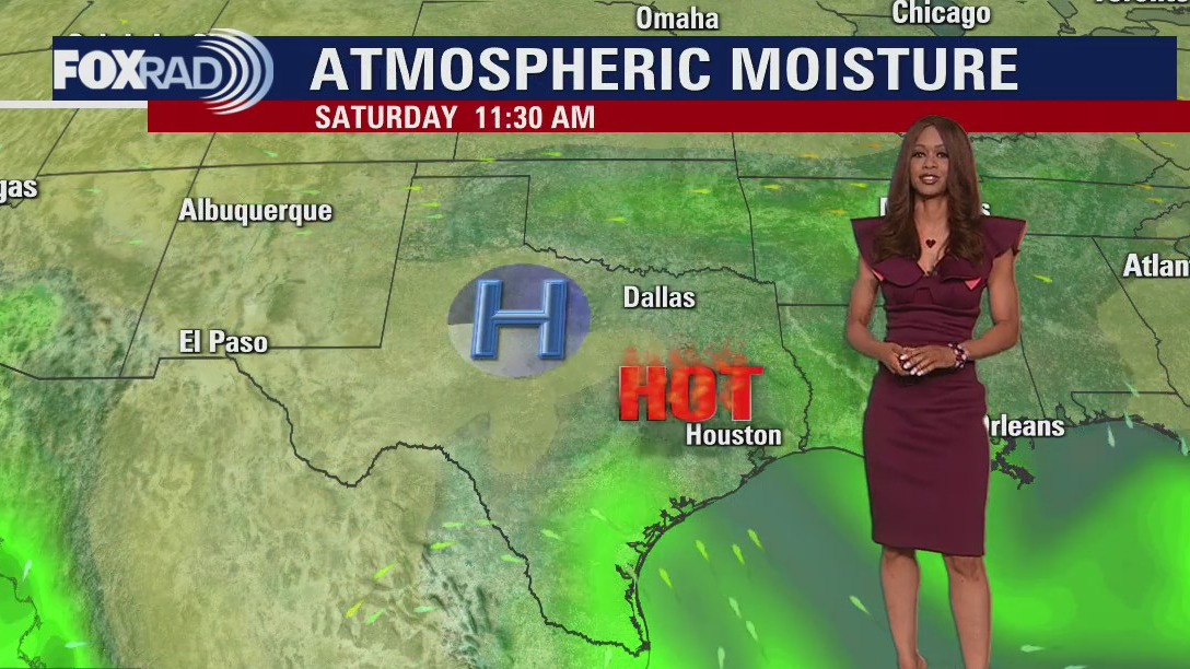
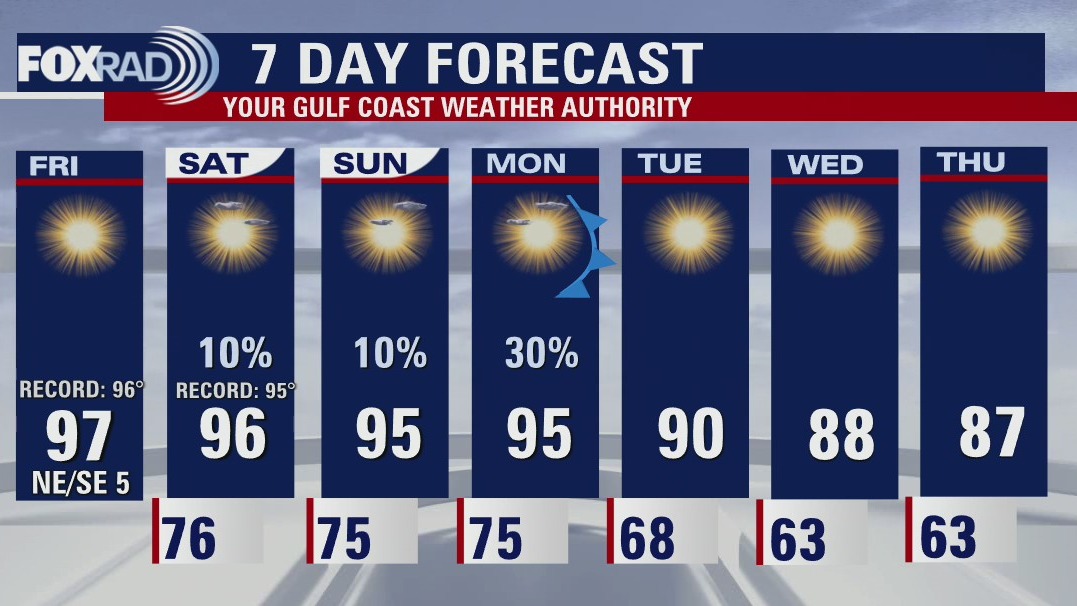
Houston will end the weekend a lot as it started. Sunday morning will see temperatures in the mid-70s with afternoon highs in the mid-90s. The abnormally hot September weather gradually fades as we move through the week. Look for conditions to seem more appropriate for the calendar starting on Wednesday.
Houston will end the weekend a lot as it started. Sunday morning will see temperatures in the mid-70s with afternoon highs in the mid-90s. The abnormally hot September weather gradually fades as we move through the week. Look for conditions to seem more appropriate for the calendar starting on Wednesday.

Tropical Weather Forecast - September 24, 2022
Ian has the attention of most of the Southeastern United States as it grows stronger in the Caribbean. Fiona, Gaston, and Hermine are also out there. Let's discuss it!
Ian has the attention of most of the Southeastern United States as it grows stronger in the Caribbean. Fiona, Gaston, and Hermine are also out there. Let's discuss it!


Hurricane Fiona: Houston PD works to donate relief items to residents in Puerto Rico
While residents in Puerto Rico continue to clean up in the aftermath of Hurricane Fiona, Houston residents banded together this weekend to send help to those on the island.
While residents in Puerto Rico continue to clean up in the aftermath of Hurricane Fiona, Houston residents banded together this weekend to send help to those on the island.

Your Saturday Morning Forecast with Meteorologist Lena Maria Arango
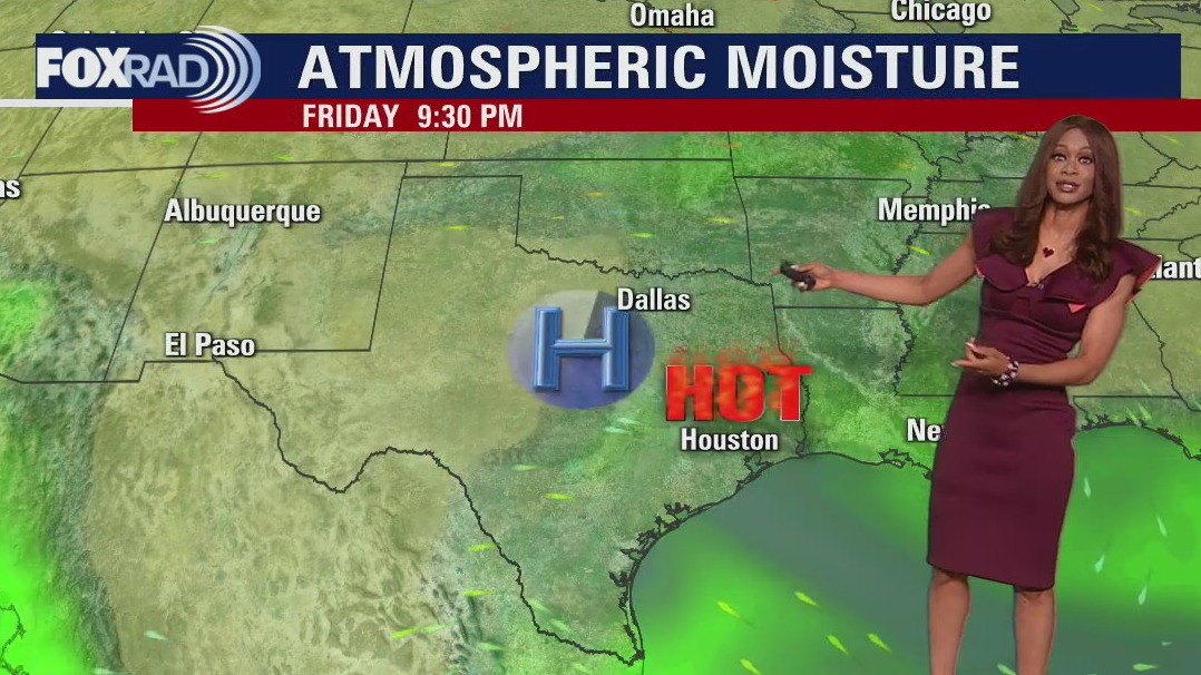
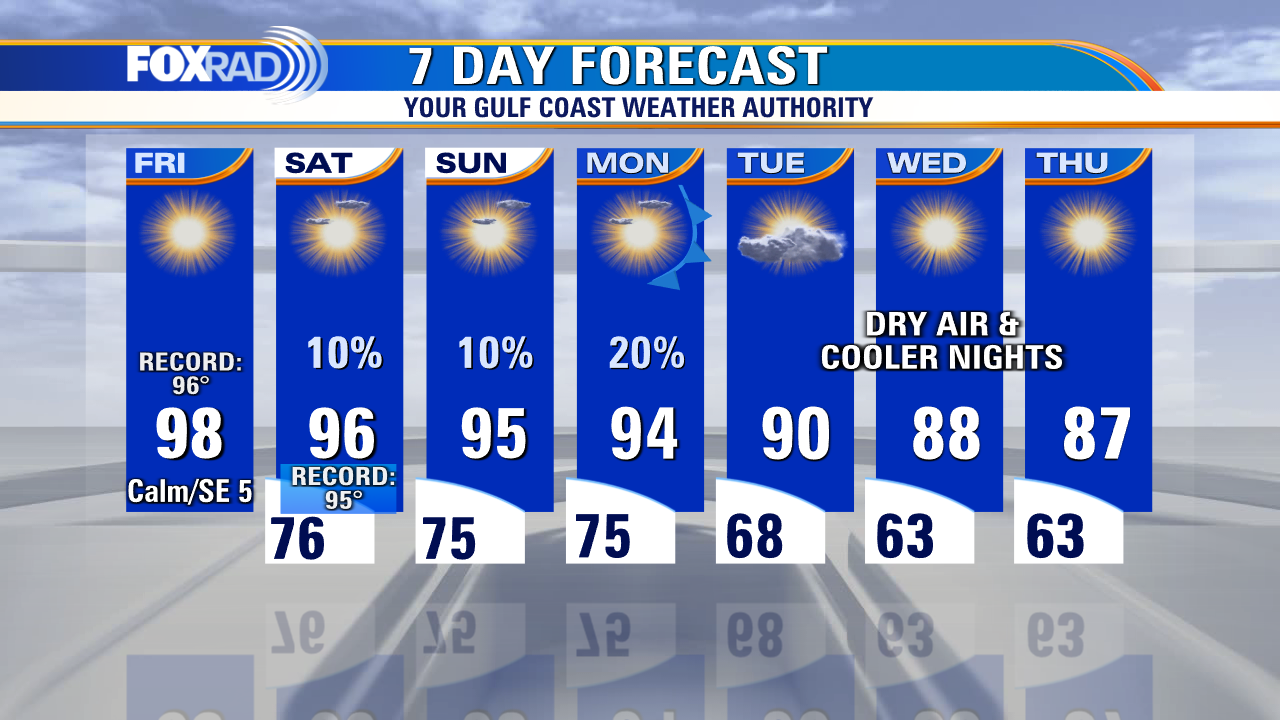
Fall may be late to the party, but is scheduled to make a fashionably late arrival by middle of next week. We have an approaching cold front to thank for that, which will also help to keep now Tropical Storm Ian east of southeast Texas. Until then, though toasty temps remain for your weekend plans. The presence of high pressure leading into the arrival of the front means that we don't have much moisture to work with. So, we won't see much in the way of rain over the course of the next week.
Fall may be late to the party, but is scheduled to make a fashionably late arrival by middle of next week. We have an approaching cold front to thank for that, which will also help to keep now Tropical Storm Ian east of southeast Texas. Until then, though toasty temps remain for your weekend plans. The presence of high pressure leading into the arrival of the front means that we don't have much moisture to work with. So, we won't see much in the way of rain over the course of the next week.

Saturday morning weather forecast
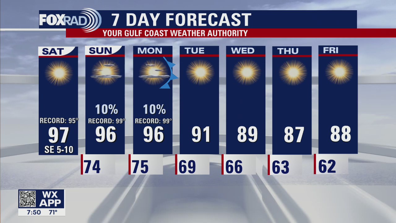
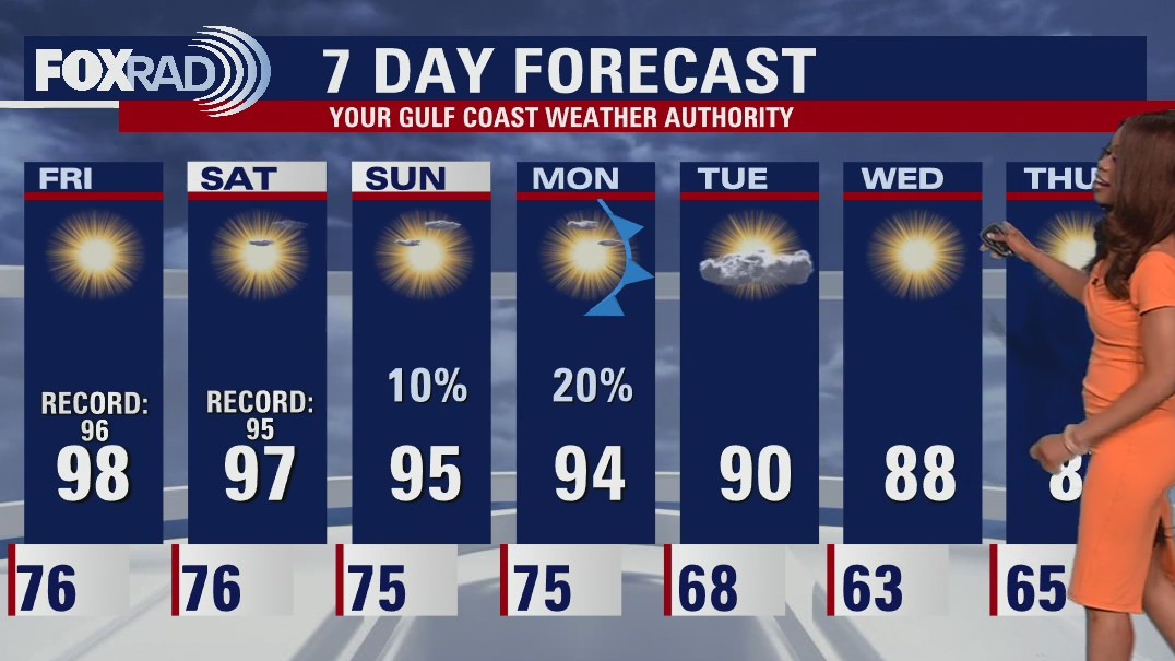
Strong ridge of high pressure over Texas will mean the threat for more record high temperatures Saturday in the middle to upper 90s. That high breaks down through by next week allowing a cold front to swing through bringing slightly cooler air and small rain chances. That front should also help to steer Tropical Depression #9 away from SE TX and push it towards Florida. We are also still tracking Category 3 hurricane Fiona headed to the Canadian Maritimes, Tropical Storm Gaston impacting the Azores, newly formed Tropical Storm Hermine in the eastern Atlantic and a tropical wave in the south central Atlantic.
Strong ridge of high pressure over Texas will mean the threat for more record high temperatures Saturday in the middle to upper 90s. That high breaks down through by next week allowing a cold front to swing through bringing slightly cooler air and small rain chances. That front should also help to steer Tropical Depression #9 away from SE TX and push it towards Florida. We are also still tracking Category 3 hurricane Fiona headed to the Canadian Maritimes, Tropical Storm Gaston impacting the Azores, newly formed Tropical Storm Hermine in the eastern Atlantic and a tropical wave in the south central Atlantic.
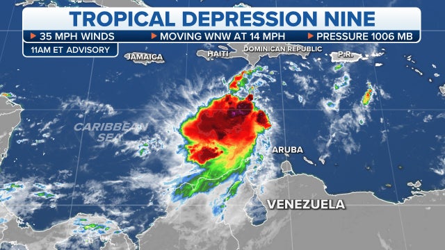

Tropical Depression 9 in Caribbean Sea forecast to become major hurricane that could threaten Florida
Hurricane Watch issued for Cayman Islands while a Tropical Storm Watch has been issued for Jamaica. No alerts for the U.S. at this time.
Hurricane Watch issued for Cayman Islands while a Tropical Storm Watch has been issued for Jamaica. No alerts for the U.S. at this time.

Friday evening weather forecast
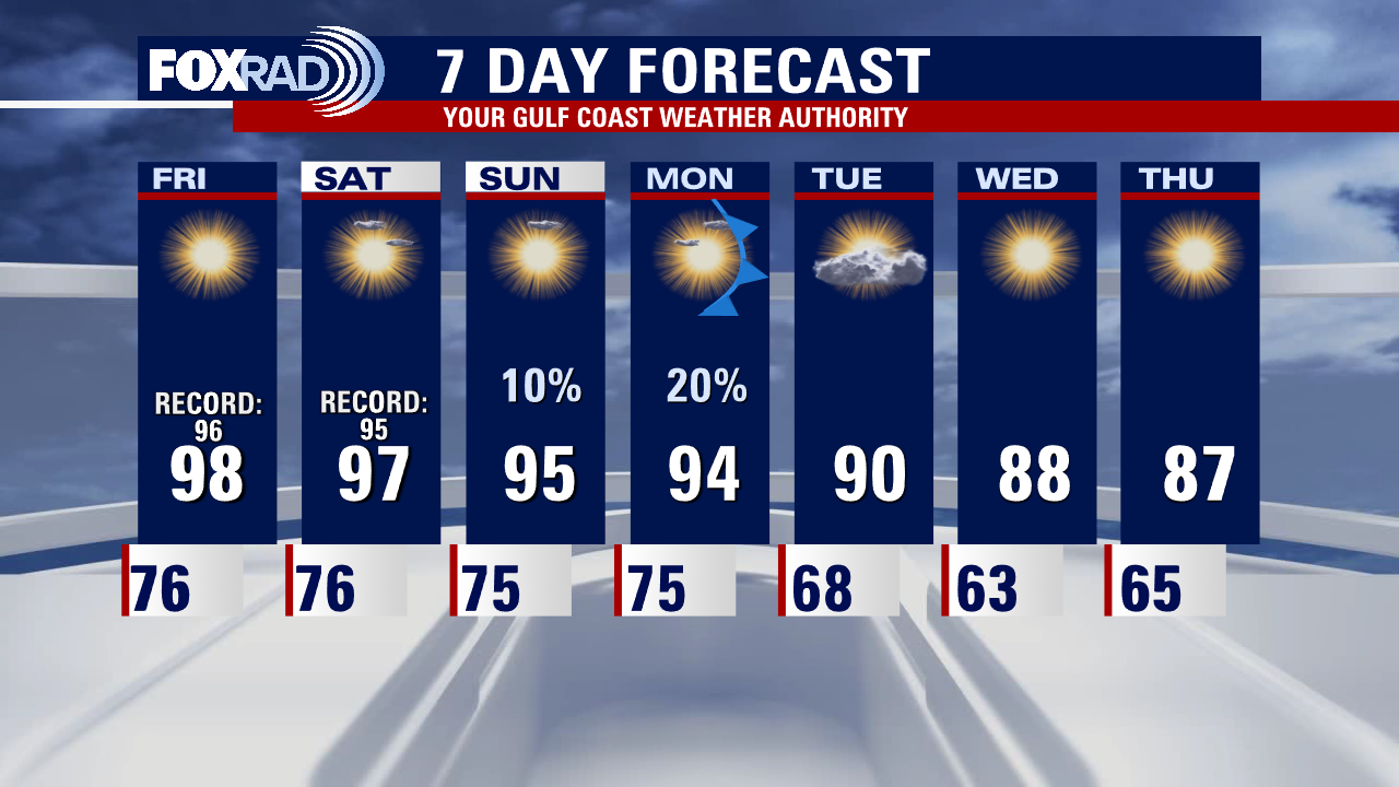
A Strong ridge of high pressure over Texas will mean the threat for more record high temperatures Saturday in the middle to upper 90s. That high breaks down through by next week allowing a cold front to swing through bringing slightly cooler air and small rain chances. That front should also help to steer Tropical Depression #9 away from SE TX and push it towards Florida. We are also still tracking Category 3 hurricane Fiona headed to the Canadian Maritimes, Tropical Storm Gaston impacting the Azores, newly formed Tropical Storm Hermine in the eastern Atlantic and a tropical wave in the south central Atlantic.
A Strong ridge of high pressure over Texas will mean the threat for more record high temperatures Saturday in the middle to upper 90s. That high breaks down through by next week allowing a cold front to swing through bringing slightly cooler air and small rain chances. That front should also help to steer Tropical Depression #9 away from SE TX and push it towards Florida. We are also still tracking Category 3 hurricane Fiona headed to the Canadian Maritimes, Tropical Storm Gaston impacting the Azores, newly formed Tropical Storm Hermine in the eastern Atlantic and a tropical wave in the south central Atlantic.

Tropical Weather Forecast - September 23, 2022
Tropics are super active with Category 3 hurricane Fiona headed to the Canadian Maritimes, Tropical Storm Gaston impacting the Azores, newly formed Tropical Storm Hermine in the eastern Atlantic and a tropical wave in the south central Atlantic. We are keeping a close eye on Tropical Depression #9 in the SE Caribbean which is forecast to get much stronger by early next week threatening Cuba and the Florida peninsula. It's not expected to be a threat to SE TX at this point though.
Tropics are super active with Category 3 hurricane Fiona headed to the Canadian Maritimes, Tropical Storm Gaston impacting the Azores, newly formed Tropical Storm Hermine in the eastern Atlantic and a tropical wave in the south central Atlantic. We are keeping a close eye on Tropical Depression #9 in the SE Caribbean which is forecast to get much stronger by early next week threatening Cuba and the Florida peninsula. It's not expected to be a threat to SE TX at this point though.


NASA moves ahead with Artemis I launch on Tuesday as Tropical Depression Nine moves toward Florida
After completing a fueling test of its mega moon rocket earlier this week, NASA engineers now have to contend with Tropical Depression Nine that appears to be aimed at Florida during the next launch attempt.
After completing a fueling test of its mega moon rocket earlier this week, NASA engineers now have to contend with Tropical Depression Nine that appears to be aimed at Florida during the next launch attempt.

Friday afternoon weather forecast with Chief Meteorologist Mike Iscovitz
A tropical system will gain strength in the Caribbean this weekend, but a cold front moving toward Texas will most likely steer that potential hurricane away from Houston. In the meantime, expect hot sunshine and record highs today and tomorrow with the mid-90s staying with us until Monday. Early next week, a front will bring us much drier air as Florida will be drenched with heavy rain and potentially high winds.
A tropical system will gain strength in the Caribbean this weekend, but a cold front moving toward Texas will most likely steer that potential hurricane away from Houston. In the meantime, expect hot sunshine and record highs today and tomorrow with the mid-90s staying with us until Monday. Early next week, a front will bring us much drier air as Florida will be drenched with heavy rain and potentially high winds.


Hurricane Fiona: Biden vows US won't walk away from storm-struck Puerto Rico
Biden noted that hundreds of FEMA and other federal officials are already on the ground in Puerto Rico, where Hurricane Fiona caused an island-wide blackout.
Biden noted that hundreds of FEMA and other federal officials are already on the ground in Puerto Rico, where Hurricane Fiona caused an island-wide blackout.

Friday morning weather with Chief Meteorologist Mike Iscovitz
A tropical system will gain strength in the Caribbean this weekend, but a cold front moving toward Texas will most likely steer that potential hurricane away from Houston. In the meantime, expect hot sunshine and record highs today and tomorrow with mid 90s staying with us until Monday. Early next week, a front will bring us much drier air as Florida will be drenched with heavy rain and potentially high winds.
A tropical system will gain strength in the Caribbean this weekend, but a cold front moving toward Texas will most likely steer that potential hurricane away from Houston. In the meantime, expect hot sunshine and record highs today and tomorrow with mid 90s staying with us until Monday. Early next week, a front will bring us much drier air as Florida will be drenched with heavy rain and potentially high winds.

Friday morning weather forecast
Record heat is expected across Houston over the next few days as a strong ridge of high pressure continues to dominate our area. We will be near triple digits through Saturday with mainly dry weather. Weak cold front is expected to bring some relief next week on Monday and possibly help to steer a tropical system away from SE TX. Tropical wave in the SE Caribbean is expected to move west and has a 80-90% chance for development over the next 2-5 days. Models are projecting this will move W then NW through the Caribbean then turn north into the Gulf of Mexico next week. Models are disagreeing with where it will head once it reaches the Gulf so it is something we are monitoring closely.
Record heat is expected across Houston over the next few days as a strong ridge of high pressure continues to dominate our area. We will be near triple digits through Saturday with mainly dry weather. Weak cold front is expected to bring some relief next week on Monday and possibly help to steer a tropical system away from SE TX. Tropical wave in the SE Caribbean is expected to move west and has a 80-90% chance for development over the next 2-5 days. Models are projecting this will move W then NW through the Caribbean then turn north into the Gulf of Mexico next week. Models are disagreeing with where it will head once it reaches the Gulf so it is something we are monitoring closely.
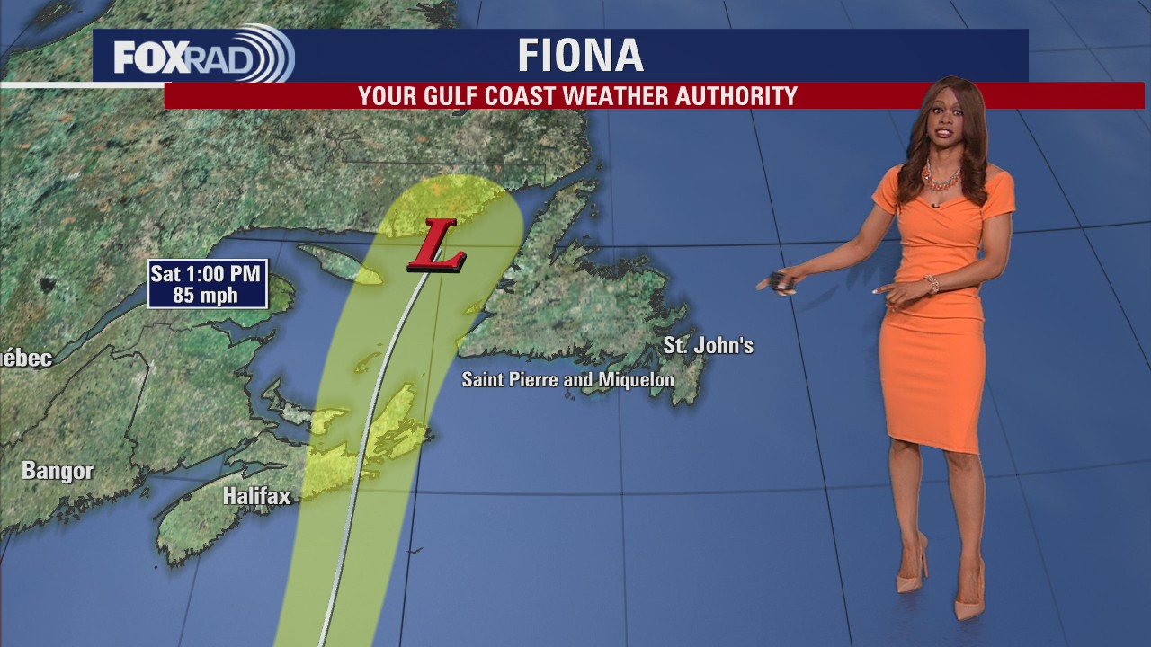
Category 4 Hurricane Fiona bearing down on Bermuda before pummeling Atlantic Canada
Widespread power outages, downed trees and structural damage are all potential impacts of Fiona in Atlantic Canada, regardless of whether it has transitioned to a post-tropical cyclone or if it's still a hurricane.
Widespread power outages, downed trees and structural damage are all potential impacts of Fiona in Atlantic Canada, regardless of whether it has transitioned to a post-tropical cyclone or if it's still a hurricane.

Thursday evening weather forecast with Meteorologist Remeisha Shade
Record heat is expected across Houston over the next few days as a strong ridge of high pressure continues to dominate our area. We will be near triple digits through Saturday with mainly dry weather. A weak cold front is expected to bring some relief next week on Monday and possibly help to steer a tropical system away from SE TX. A tropical wave in the SE Caribbean is expected to move west and has an 80-90% chance for development over the next 2-5 days. Models are projecting this will move W then NW through the Caribbean then turn north into the Gulf of Mexico next week. Models are disagreeing with where it will head once it reaches the Gulf so it is something we are monitoring closely.
Record heat is expected across Houston over the next few days as a strong ridge of high pressure continues to dominate our area. We will be near triple digits through Saturday with mainly dry weather. A weak cold front is expected to bring some relief next week on Monday and possibly help to steer a tropical system away from SE TX. A tropical wave in the SE Caribbean is expected to move west and has an 80-90% chance for development over the next 2-5 days. Models are projecting this will move W then NW through the Caribbean then turn north into the Gulf of Mexico next week. Models are disagreeing with where it will head once it reaches the Gulf so it is something we are monitoring closely.

Tropical Weather Forecast - September 22, 2022
Invest 98-L is in the SE Caribbean and has an 80% chance for development over the next 48 hours and a 90% chance for development over the next 5 days. Models are in good agreement that it will track west through the Caribbean and eventually turn NW this weekend. But after 3-4 days, models disagree on where this system will head and that means everyone along the Gulf Coast should stay weather aware and keep checking in with the FOX 26 Weather Team daily. It still appears a front will dip down early next week and try to steer the system NE but there are several factors that are in play that could change the strength and track of this developing system. Once it gets going, it will have plenty of warm water and a low-shear environment for quick strengthening so it's something to pay close attention to. Fiona is still a major hurricane with 130 mph winds headed close to Bermuda tonight where hurricane warnings are in effect. Gaston is still a tropical storm with 65 mph winds which could bring some heavy rain and strong winds to the Azores.
Invest 98-L is in the SE Caribbean and has an 80% chance for development over the next 48 hours and a 90% chance for development over the next 5 days. Models are in good agreement that it will track west through the Caribbean and eventually turn NW this weekend. But after 3-4 days, models disagree on where this system will head and that means everyone along the Gulf Coast should stay weather aware and keep checking in with the FOX 26 Weather Team daily. It still appears a front will dip down early next week and try to steer the system NE but there are several factors that are in play that could change the strength and track of this developing system. Once it gets going, it will have plenty of warm water and a low-shear environment for quick strengthening so it's something to pay close attention to. Fiona is still a major hurricane with 130 mph winds headed close to Bermuda tonight where hurricane warnings are in effect. Gaston is still a tropical storm with 65 mph winds which could bring some heavy rain and strong winds to the Azores.

Thursday afternoon weather forecast with Meteorologist Lena Maria
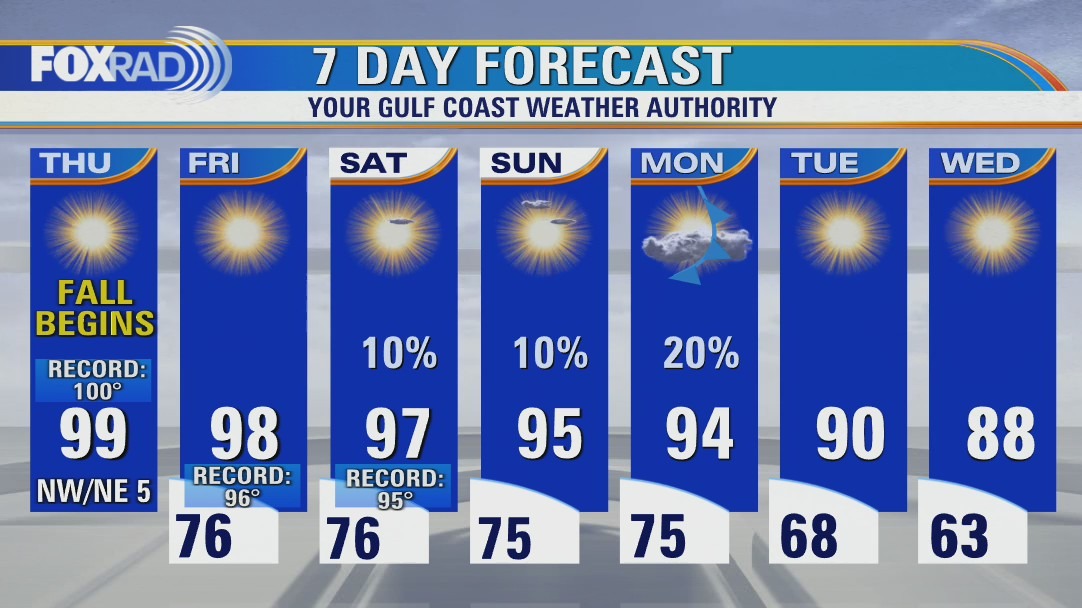
"Fall" begins on a toasty note, with potentially record-breaking heat lingering into the weekend. A cool front will pull in more seasonable, refreshing temperatures and drier air for next week. It also may help act as a boundary, to steer away a developing tropical system. For the latest on that, and all other happenings in the Atlantic visit the tropics tab on our website and our in-depth discussions on YouTube.
"Fall" begins on a toasty note, with potentially record-breaking heat lingering into the weekend. A cool front will pull in more seasonable, refreshing temperatures and drier air for next week. It also may help act as a boundary, to steer away a developing tropical system. For the latest on that, and all other happenings in the Atlantic visit the tropics tab on our website and our in-depth discussions on YouTube.

Before-and-after photos show devastation in Puerto Rico after Hurricane Fiona pummels island
At least 8 deaths have been reported after Hurricane Fiona tore through the Caribbean this week.
At least 8 deaths have been reported after Hurricane Fiona tore through the Caribbean this week.

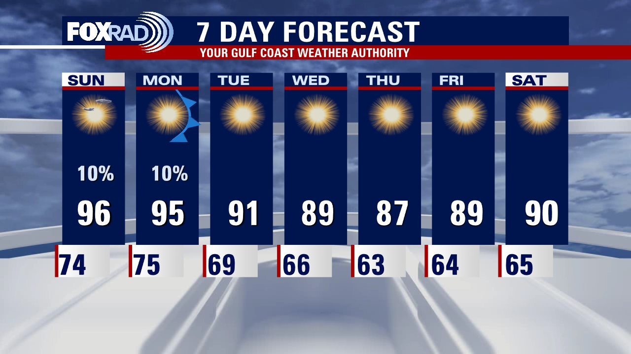
Sunny and hot with afternoon temperatures in the upper 90s
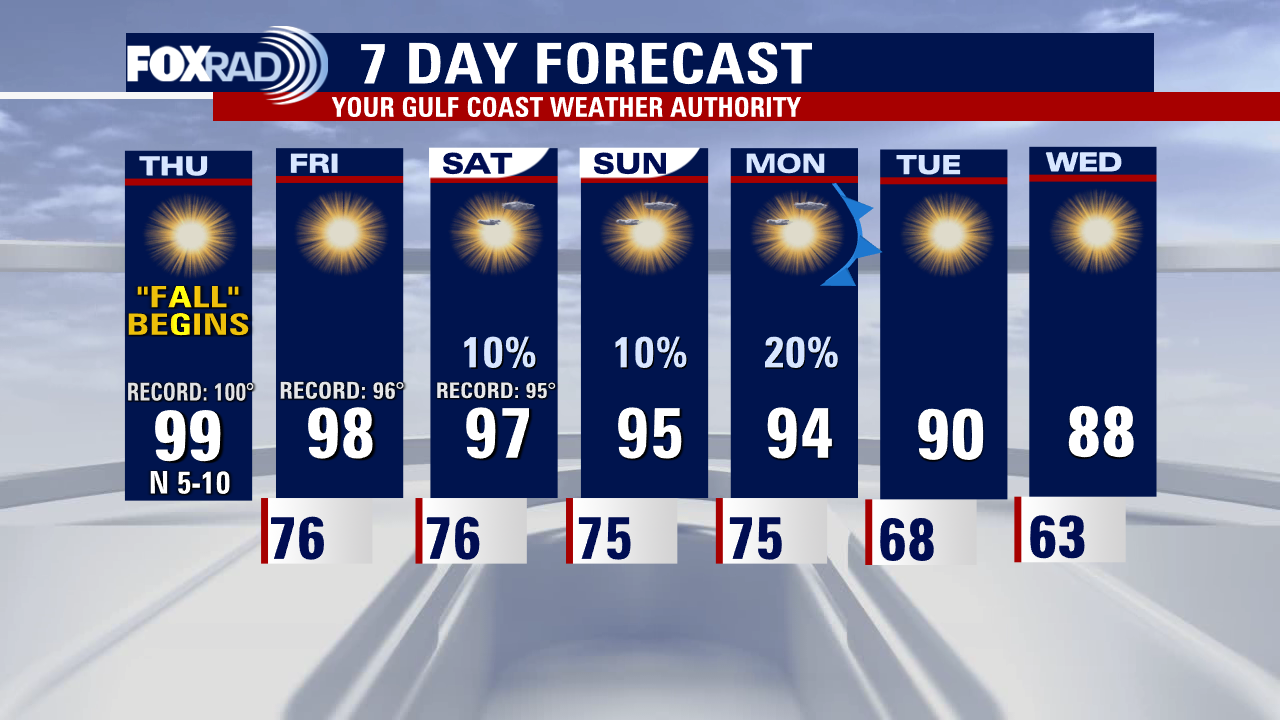
There are three headlines in our forecast over the next 7 days: 1st, record hot temperatures for the start of the fall season. 2nd, a likely tropical storm or hurricane in the Caribbean this weekend. 3rd, a cold front early next week that will bring a nice cooldown for us and could also deflect the aforementioned tropical system. We'll keep you updated on the progress of the low in the Caribbean.
There are three headlines in our forecast over the next 7 days: 1st, record hot temperatures for the start of the fall season. 2nd, a likely tropical storm or hurricane in the Caribbean this weekend. 3rd, a cold front early next week that will bring a nice cooldown for us and could also deflect the aforementioned tropical system. We'll keep you updated on the progress of the low in the Caribbean.