


Texas sends search and rescue crews to Florida to help with Hurricane Ian
Texas Governor Greg Abbott activated Texas A&M Task Force 1 Tuesday to help Florida with Hurricane Ian recovery.
Texas Governor Greg Abbott activated Texas A&M Task Force 1 Tuesday to help Florida with Hurricane Ian recovery.
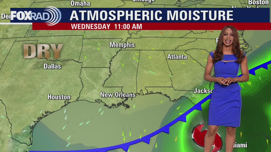

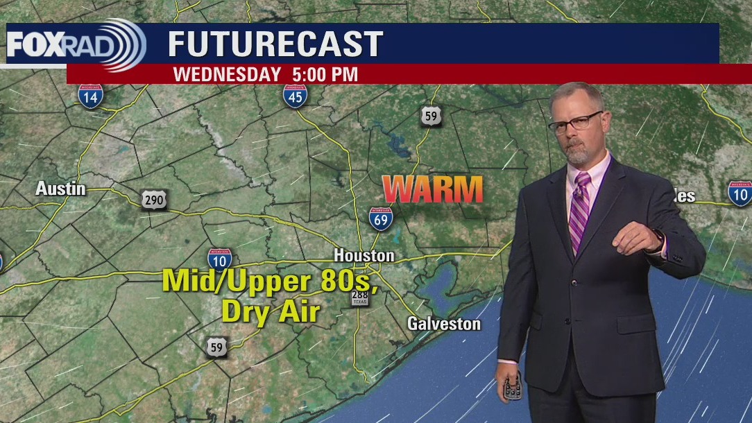
Wednesday morning weather forecast
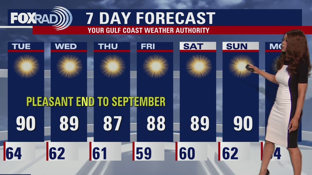
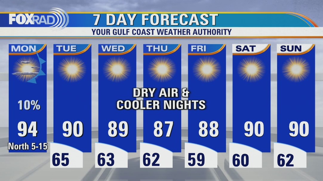
Phenomenal weather persists for Houston and the rest of SE Texas with high pressure in control and very dry air in place. We'll have pleasant nights in the 50s and 60s through the end of the week and near average high temperatures in the afternoon near 90. Hurricane Ian remains a very dangerous major Category 3 hurricane in the SE Gulf of Mexico growing stronger and getting closer to Florida. Hurricane warnings remain in place for Tampa and Fort Myers, where major flooding, storm surge, hurricane force winds and possible tornadoes are expected.
Phenomenal weather persists for Houston and the rest of SE Texas with high pressure in control and very dry air in place. We'll have pleasant nights in the 50s and 60s through the end of the week and near average high temperatures in the afternoon near 90. Hurricane Ian remains a very dangerous major Category 3 hurricane in the SE Gulf of Mexico growing stronger and getting closer to Florida. Hurricane warnings remain in place for Tampa and Fort Myers, where major flooding, storm surge, hurricane force winds and possible tornadoes are expected.
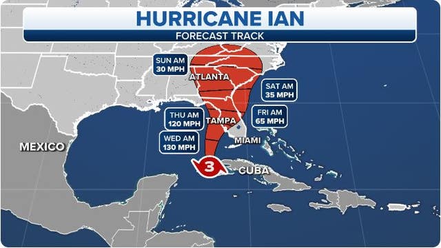

Hurricane Ian could make landfall along Florida's Gulf Coast as a dangerous major hurricane near Tampa Bay
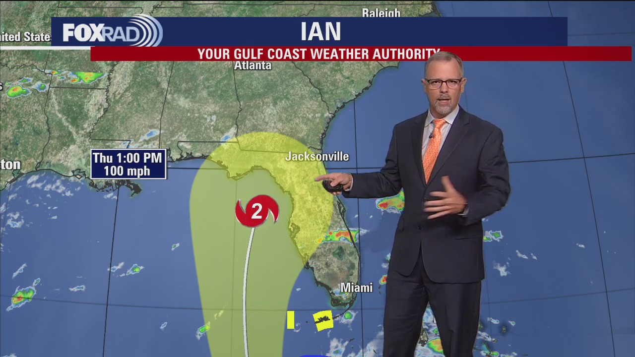
If Hurricane Ian follows a track near the center of the forecast cone, it would be nearly a worst-case scenario for the Tampa Bay area because the powerful winds in Ian's eyewall would plow through the cities of Tampa, St. Petersburg and Clearwater.
If Hurricane Ian follows a track near the center of the forecast cone, it would be nearly a worst-case scenario for the Tampa Bay area because the powerful winds in Ian's eyewall would plow through the cities of Tampa, St. Petersburg and Clearwater.
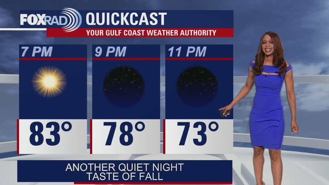

Tuesday evening weather forecast
Phenomenal weather persists for Houston and the rest of SE Texas with high pressure in control and very dry air in place. We'll have pleasant nights in the 50s and 60s through the end of the week and near average high temperatures in the afternoon near 90. Hurricane Ian remains a very dangerous major Category 3 hurricane in the SE Gulf of Mexico growing stronger and getting closer to Florida. Hurricane warnings remain in place for Tampa and Fort Myers, where major flooding, storm surge, hurricane force winds and possible tornadoes are expected.
Phenomenal weather persists for Houston and the rest of SE Texas with high pressure in control and very dry air in place. We'll have pleasant nights in the 50s and 60s through the end of the week and near average high temperatures in the afternoon near 90. Hurricane Ian remains a very dangerous major Category 3 hurricane in the SE Gulf of Mexico growing stronger and getting closer to Florida. Hurricane warnings remain in place for Tampa and Fort Myers, where major flooding, storm surge, hurricane force winds and possible tornadoes are expected.


Hurricane Ian offers important reminder how to care for, use a generator
When Hurricane Ian hits Florida, thousands will likely be left without power. Before a storm heads toward Texas, now is the time to make sure storm-plans are ready to go, if they're needed.
When Hurricane Ian hits Florida, thousands will likely be left without power. Before a storm heads toward Texas, now is the time to make sure storm-plans are ready to go, if they're needed.

Tropical Weather Forecast - September 27, 2022
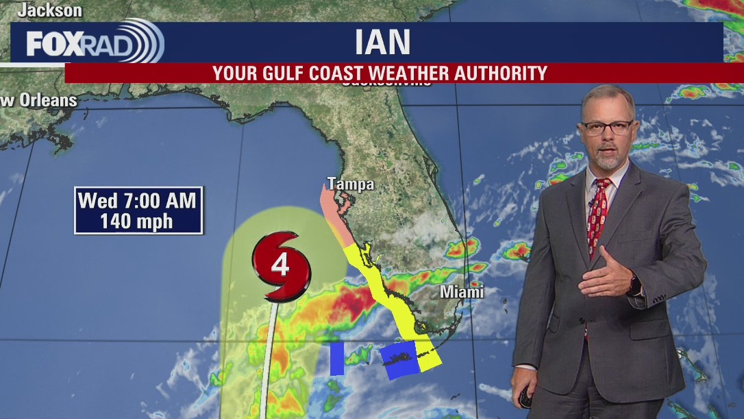
Hurricane Ian is a major Category 3 Hurricane in the SE Gulf of Mexico with Maximum sustained winds around 120 mph. Ian is forecast to strengthen to an even stronger Category 4 hurricane by Wednesday before making landfall by the afternoon and evening between Tampa and Fort Myers. Major storm surge, tornadoes and devastating flooding will be possible as this hurricane will have widespread impacts all across the state of Florida.
Hurricane Ian is a major Category 3 Hurricane in the SE Gulf of Mexico with Maximum sustained winds around 120 mph. Ian is forecast to strengthen to an even stronger Category 4 hurricane by Wednesday before making landfall by the afternoon and evening between Tampa and Fort Myers. Major storm surge, tornadoes and devastating flooding will be possible as this hurricane will have widespread impacts all across the state of Florida.


Hurricane Ian: Texas sending search-and-rescue team, boats to Florida
With destructive Hurricane Ian expected to strengthen and make landfall in Florida late Wednesday, Texas Gov. Greg Abbott is sending help to the Sunshine State.
With destructive Hurricane Ian expected to strengthen and make landfall in Florida late Wednesday, Texas Gov. Greg Abbott is sending help to the Sunshine State.

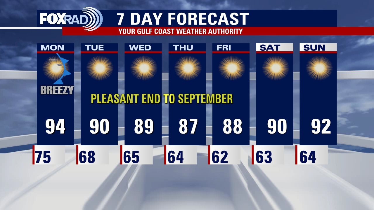
Expect a warm and dry Tuesday afternoon in the upper 80s
As evacuations take place on the Gulf Coast of Florida, the weather in our area couldn't be nicer. We woke up to 50s and 60s this morning and each afternoon for the rest of the week will be sunny, warm, and very dry with highs in the upper 80s. Hurricane Ian is expected to slam the west coast of Florida with major hurricane winds, a damaging storm surge, and more than 10" of rain through the day Wednesday and Thursday.
As evacuations take place on the Gulf Coast of Florida, the weather in our area couldn't be nicer. We woke up to 50s and 60s this morning and each afternoon for the rest of the week will be sunny, warm, and very dry with highs in the upper 80s. Hurricane Ian is expected to slam the west coast of Florida with major hurricane winds, a damaging storm surge, and more than 10" of rain through the day Wednesday and Thursday.
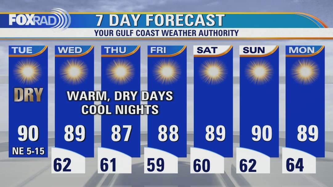

Cooler Tuesday morning, then sunny and dry with highs near 90
As evacuations take place on the Gulf Coast of Florida, weather in our area couldn't be nicer. We woke up to 50s and 60s this morning and that trend will continue for the rest of the week. Each afternoon will be sunny, warm and very dry with highs in the upper 80s, Hurricane Ian is expected to slam the west coast of Florida with major hurricane winds, a damaging storm surge and more than 10" of rain through the day Wednesday and Thursday.
As evacuations take place on the Gulf Coast of Florida, weather in our area couldn't be nicer. We woke up to 50s and 60s this morning and that trend will continue for the rest of the week. Each afternoon will be sunny, warm and very dry with highs in the upper 80s, Hurricane Ian is expected to slam the west coast of Florida with major hurricane winds, a damaging storm surge and more than 10" of rain through the day Wednesday and Thursday.


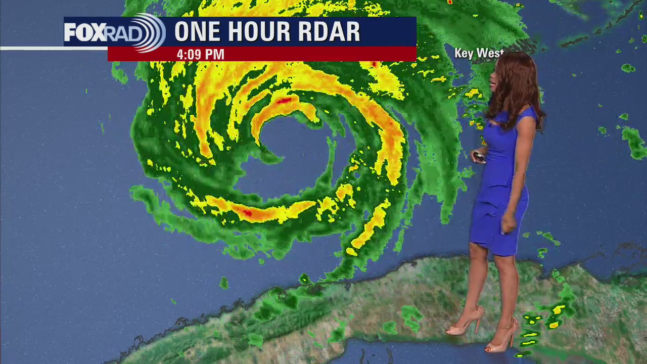
This is what Hurricane Ian looked like from the International Space Station - 260 miles away
What does Hurricane Ian look like from space?
What does Hurricane Ian look like from space?


Houston storm chaser heading to Florida for Hurricane Ian
A storm chaser from Houston is packing up his bags and heading to Florida for Hurricane Ian.
A storm chaser from Houston is packing up his bags and heading to Florida for Hurricane Ian.


Houstonians headed to help in Florida ahead of Hurricane Ian
Hurricane Ian is expected to slam parts of Florida and a number of Houstonians will be right there, volunteering and helping.
Hurricane Ian is expected to slam parts of Florida and a number of Houstonians will be right there, volunteering and helping.
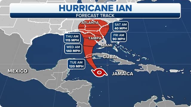

Hurricane Ian strengthens to Category 2 in Caribbean; Tampa Bay, Florida braces for major threat
A Hurricane Warning has been issued for the Tampa Bay area as mandatory evacuations have been issued for parts of the region.
A Hurricane Warning has been issued for the Tampa Bay area as mandatory evacuations have been issued for parts of the region.

Monday evening weather forecast
Weak cold front is pushing through which will bring a noticeable difference in the form of lower humidity. Temperatures will remain warm for the rest of the week in the afternoon near 90. But overnight lows will be pleasant in the 50s and 60s. Look for bright sunshine as high pressure dominates. Hurricane Ian will be no threat for SE TX but will have huge impacts in Florida and other parts of the SE over the coming days. Ian is forecast to strengthen to a major hurricane by Tuesday and head over to the western Florida Gulf coast by late Wednesday & early Thursday.
Weak cold front is pushing through which will bring a noticeable difference in the form of lower humidity. Temperatures will remain warm for the rest of the week in the afternoon near 90. But overnight lows will be pleasant in the 50s and 60s. Look for bright sunshine as high pressure dominates. Hurricane Ian will be no threat for SE TX but will have huge impacts in Florida and other parts of the SE over the coming days. Ian is forecast to strengthen to a major hurricane by Tuesday and head over to the western Florida Gulf coast by late Wednesday & early Thursday.


Tropical Weather Forecast - September 26, 2022
Hurricane Ian is still undergoing rapid intensification and is now a Category 2 Hurricane with maximum sustained winds at 100 mph. Ian will keep getting stronger as it quickly crosses the western tip of Cuba tonight and then heads towards Florida late Wednesday into early Thursday. Ian is forecast to strengthen to a Category 4 Hurricane over the next 24 hours. Parts of Florida, including Tampa, are under a hurricane warning. Cuba also remains under a Hurricane Warning.
Hurricane Ian is still undergoing rapid intensification and is now a Category 2 Hurricane with maximum sustained winds at 100 mph. Ian will keep getting stronger as it quickly crosses the western tip of Cuba tonight and then heads towards Florida late Wednesday into early Thursday. Ian is forecast to strengthen to a Category 4 Hurricane over the next 24 hours. Parts of Florida, including Tampa, are under a hurricane warning. Cuba also remains under a Hurricane Warning.

Expect high temps and clear skies this Monday afternoon
Cooler air is on the way! As Hurricane Ian gains strength and threatens to bring heavy rain and a serious storm surge to Florida, our weather will be the complete opposite. Expect sunshine and increasingly dry air with overnight lows in the 50s and 60s! Today will be hot, but with drier air moving in from the north.
Cooler air is on the way! As Hurricane Ian gains strength and threatens to bring heavy rain and a serious storm surge to Florida, our weather will be the complete opposite. Expect sunshine and increasingly dry air with overnight lows in the 50s and 60s! Today will be hot, but with drier air moving in from the north.


Hurricane Gear Test: Guzzle H2O Stream Drinking Water System
What do you do if you don't have clean water in a storm? FOX 26 Meteorologist John Dawson takes a look at the Guzzle H2O Stream Drinking Water System.
What do you do if you don't have clean water in a storm? FOX 26 Meteorologist John Dawson takes a look at the Guzzle H2O Stream Drinking Water System.

Muggy Monday morning, then sunny, hot and much less humid
Cooler air is on the way! As Hurricane Ian gains strength and threatens to bring heavy rain and serious storm surge to Florida, our weather will be the complete opposite. Expect sunshine and increasingly dry air with overnight lows in the 50s and 60s! Today will be hot, but with drier air moving in from the north.
Cooler air is on the way! As Hurricane Ian gains strength and threatens to bring heavy rain and serious storm surge to Florida, our weather will be the complete opposite. Expect sunshine and increasingly dry air with overnight lows in the 50s and 60s! Today will be hot, but with drier air moving in from the north.

Sunday night leading into Monday morning weather forecast
The unusually hot temperatures over the weekend should start to transition back to normal on Monday. The mornings in Houston will be noticeably drier and cooler starting on Tuesday. The pleasant, less humid patter will set in for the rest of the week. Make plans to enjoy some dry afternoons with high temperatures only in the 80s!
The unusually hot temperatures over the weekend should start to transition back to normal on Monday. The mornings in Houston will be noticeably drier and cooler starting on Tuesday. The pleasant, less humid patter will set in for the rest of the week. Make plans to enjoy some dry afternoons with high temperatures only in the 80s!

Tropical Weather Forecast - September 25, 2022
Where is Ian headed and how big of a storm will it become? Uncertainty in the track and intensity forecasts remains higher than usual.
Where is Ian headed and how big of a storm will it become? Uncertainty in the track and intensity forecasts remains higher than usual.