


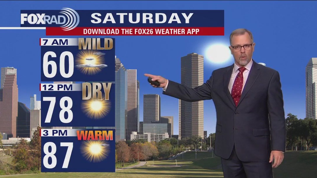
Saturday morning weather forecast with Chief Meteorologist Mike Iscovitz
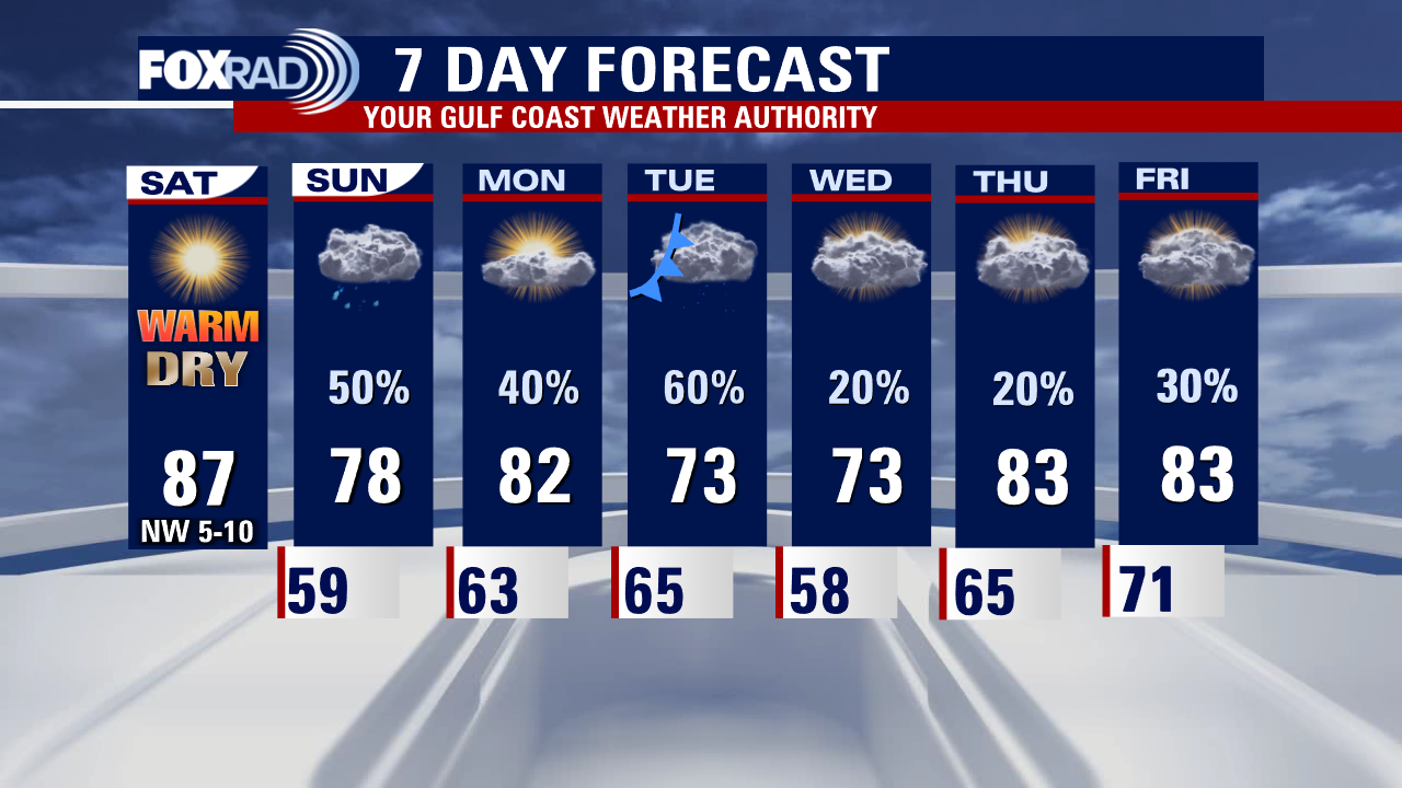
Following a weak front this morning, we'll have a sunny, very warm, and very dry Saturday. Clouds and rain should return quickly on Sunday and Monday with a generally unsettled pattern through much of next week. The weather is looking warm and humid for Astros' opening day on Thursday.
Following a weak front this morning, we'll have a sunny, very warm, and very dry Saturday. Clouds and rain should return quickly on Sunday and Monday with a generally unsettled pattern through much of next week. The weather is looking warm and humid for Astros' opening day on Thursday.

Saturday morning Houston-area weather forecast
The weekend starts beautiful but warm. Drier air remains in place on Saturday but a warm front brings back humidity and some showers around Houston on Sunday. Monday will see temps return to the lower 80s with scattered showers possible. Mild for the rest of the will with a few showers around.
The weekend starts beautiful but warm. Drier air remains in place on Saturday but a warm front brings back humidity and some showers around Houston on Sunday. Monday will see temps return to the lower 80s with scattered showers possible. Mild for the rest of the will with a few showers around.
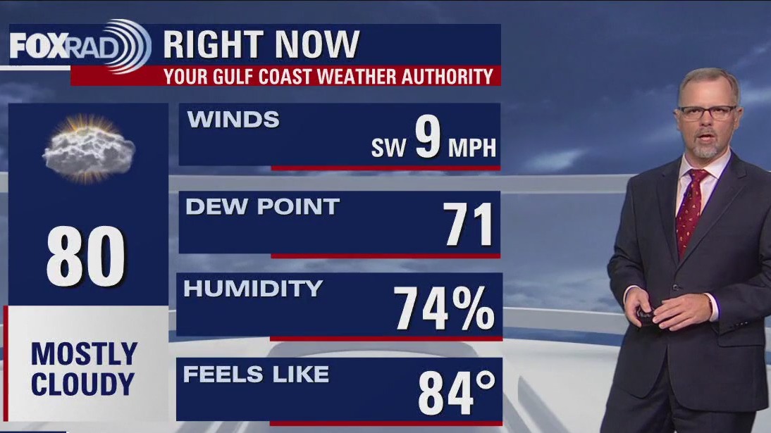

Mostly cloudy, warm Friday evening in the 80s
The weekend starts beautiful but warm. Drier air remains in place on Saturday but a warm front brings back humidity and some showers around Houston on Sunday. Monday will see temps return to the lower 80s with scattered showers possible. Mild for the rest of the will with a few showers around.
The weekend starts beautiful but warm. Drier air remains in place on Saturday but a warm front brings back humidity and some showers around Houston on Sunday. Monday will see temps return to the lower 80s with scattered showers possible. Mild for the rest of the will with a few showers around.

Houston weather: Storms possible across Houston area on Friday afternoon
A storm system that produced a rare tornado near Los Angeles Wednesday will be bringing the Houston-area some weather changes for the end of the work week on Friday.
A storm system that produced a rare tornado near Los Angeles Wednesday will be bringing the Houston-area some weather changes for the end of the work week on Friday.

Houston weather: Scattered afternoon showers and storms
Showers and a few storms are likely by early this afternoon - the tail end of a round of severe weather that hit the DFW area this morning and could cause an outbreak of severe storms in Louisiana, Mississippi, Arkansas and Tennessee today. For your weekend plans, Saturday looks beautiful with drier air and warm sunshine. Clouds and showers return Sunday through much of next week.
Showers and a few storms are likely by early this afternoon - the tail end of a round of severe weather that hit the DFW area this morning and could cause an outbreak of severe storms in Louisiana, Mississippi, Arkansas and Tennessee today. For your weekend plans, Saturday looks beautiful with drier air and warm sunshine. Clouds and showers return Sunday through much of next week.

Houston weather: Scattered afternoon showers and storms Friday
Showers and a few storms are likely by early this afternoon - the tail end of a round of severe weather that hit the DFW area this morning and could cause an outbreak of severe storms in Louisiana, Mississippi, Arkansas and Tennessee today. For your weekend plans, Saturday looks beautiful with drier air and warm sunshine. Clouds and showers return Sunday through much of next week.
Showers and a few storms are likely by early this afternoon - the tail end of a round of severe weather that hit the DFW area this morning and could cause an outbreak of severe storms in Louisiana, Mississippi, Arkansas and Tennessee today. For your weekend plans, Saturday looks beautiful with drier air and warm sunshine. Clouds and showers return Sunday through much of next week.

Friday morning Houston-area weather forecast
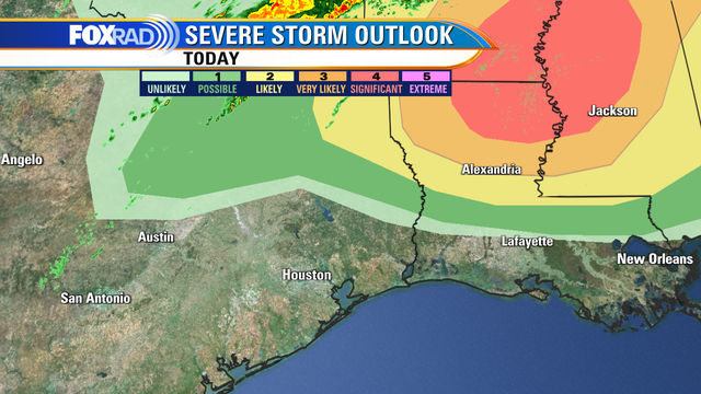
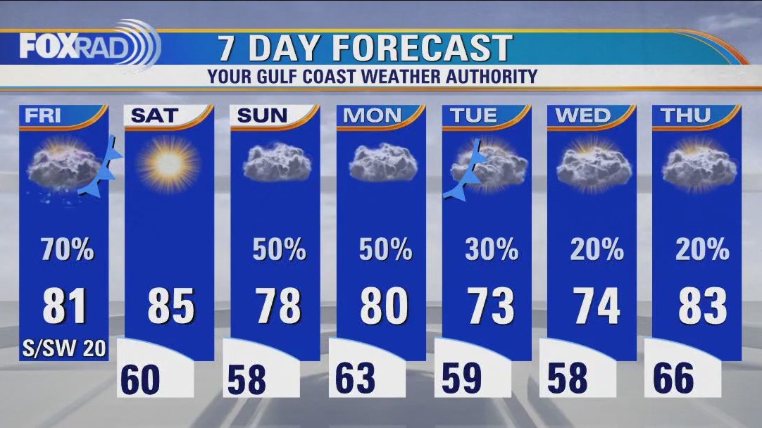
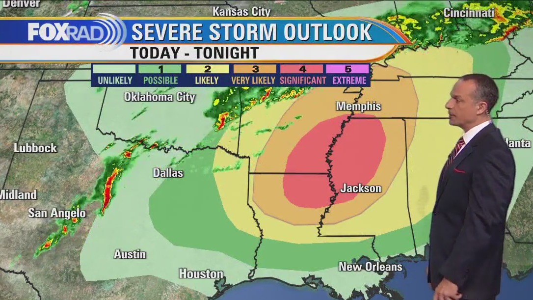
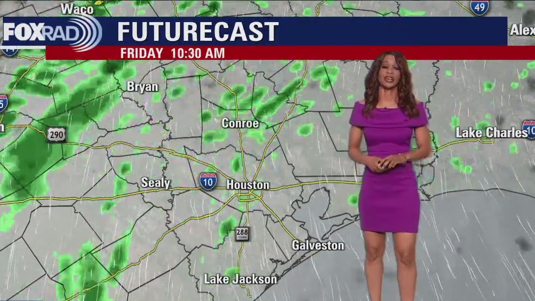
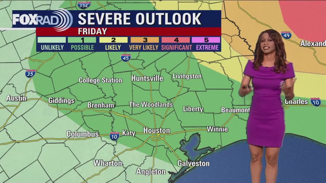
We start off near 70 Friday and climb to around 80 by the afternoon. Dryline and cold front will move in Friday with the best chance for storms during the afternoon. There is a limited severe threat with the best chance NE of Houston. Main threat for us will be a brief strong wind gust or two around 50-70 mph, heavy rain and hail. The tornado threat is very low here but much higher into parts of Louisiana, Arkansas, & Mississippi where a big tornado outbreak is likely tomorrow. Sunny and warm weather is expected Saturday with temperatures soaring into the middle 80s. Look for more storms to return on Sunday. So you may want to get in your picnic & golf plans for the weekend on Saturday. Make sure to grab the FOX 26 weather app.
We start off near 70 Friday and climb to around 80 by the afternoon. Dryline and cold front will move in Friday with the best chance for storms during the afternoon. There is a limited severe threat with the best chance NE of Houston. Main threat for us will be a brief strong wind gust or two around 50-70 mph, heavy rain and hail. The tornado threat is very low here but much higher into parts of Louisiana, Arkansas, & Mississippi where a big tornado outbreak is likely tomorrow. Sunny and warm weather is expected Saturday with temperatures soaring into the middle 80s. Look for more storms to return on Sunday. So you may want to get in your picnic & golf plans for the weekend on Saturday. Make sure to grab the FOX 26 weather app.

Mild, muggy, breezy Thursday evening in the 80s
Mild, muggy & breezy weather sticks around tonight as we wait for our next storm system set to arrive Friday. We start off near 70 Friday and climb to around 80 by the afternoon. Dryline and cold front will move in Friday with the best chance for storms during the afternoon. There is a limited severe threat with the best chance NE of Houston. Main threat for us will be a brief strong wind gust or two around 50-70 mph, heavy rain and hail. The tornado threat is very low here but much higher into parts of Louisiana, Arkansas, & Mississippi where a big tornado outbreak is likely tomorrow. Sunny and warm weather is expected Saturday with temperatures soaring into the middle 80s. Look for more storms to return on Sunday. So you may want to get in your picnic & golf plans for the weekend on Saturday. Make sure to grab the FOX 26 weather app and have a great night!
Mild, muggy & breezy weather sticks around tonight as we wait for our next storm system set to arrive Friday. We start off near 70 Friday and climb to around 80 by the afternoon. Dryline and cold front will move in Friday with the best chance for storms during the afternoon. There is a limited severe threat with the best chance NE of Houston. Main threat for us will be a brief strong wind gust or two around 50-70 mph, heavy rain and hail. The tornado threat is very low here but much higher into parts of Louisiana, Arkansas, & Mississippi where a big tornado outbreak is likely tomorrow. Sunny and warm weather is expected Saturday with temperatures soaring into the middle 80s. Look for more storms to return on Sunday. So you may want to get in your picnic & golf plans for the weekend on Saturday. Make sure to grab the FOX 26 weather app and have a great night!


High winds suck teacher out of classroom
A teacher in Los Angeles gets sucked out of her classroom by powerful winds shown in a video taken by a high school student yesterday. The teacher opened the door after hearing loud noises outside.
A teacher in Los Angeles gets sucked out of her classroom by powerful winds shown in a video taken by a high school student yesterday. The teacher opened the door after hearing loud noises outside.

El Tiempo de 23 Marzo de 2023
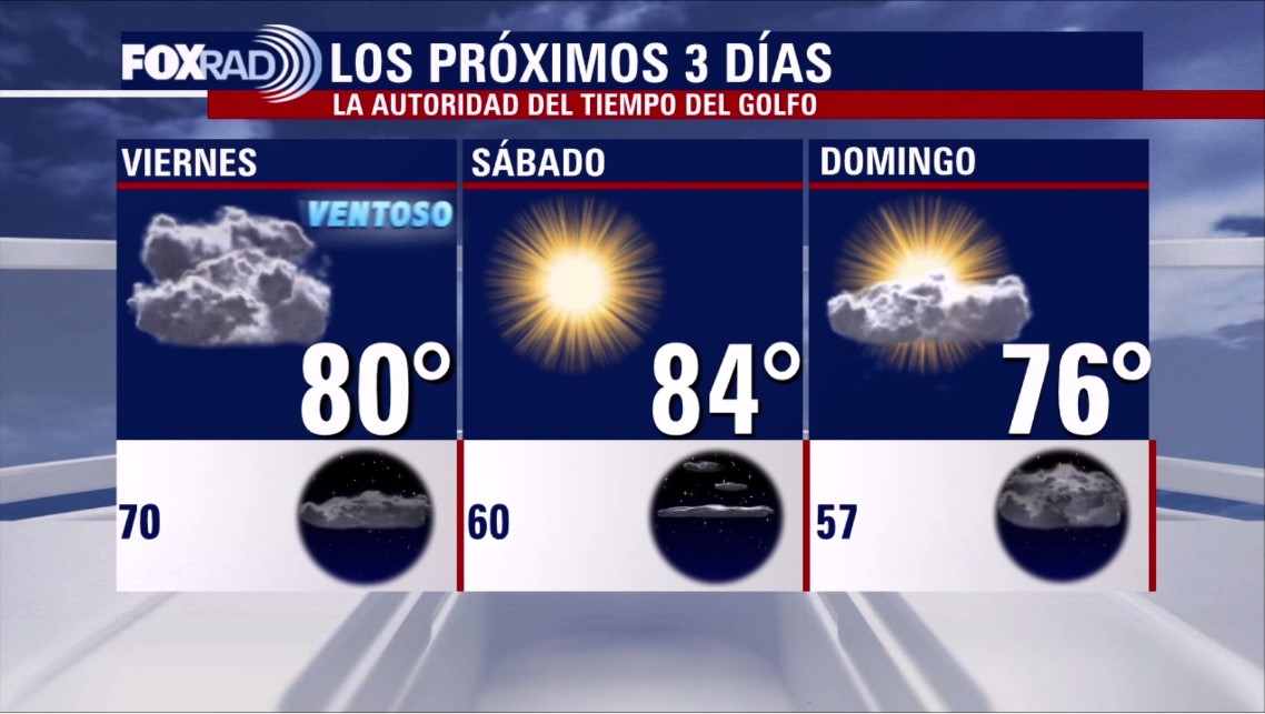
#FOX26 Meteor?loga Lena Maria Arango tiene su pron?stico para el fin de semana.
#FOX26 Meteor?loga Lena Maria Arango tiene su pron?stico para el fin de semana.

Houston weather: Muggy Thursday morning, then partly cloudy, breezy and very warm
More very warm, humid and breezy weather today with high temperatures within 3-4? of records. A disturbance that brought severe weather to California, including a very rare tornado in Los Angeles County, will move into Texas today and tomorrow. Storms are possible in the Houston area on Friday mainly in the afternoon. This weekend, Saturday looks great, but Sunday could see the return of clouds and scattered showers.
More very warm, humid and breezy weather today with high temperatures within 3-4? of records. A disturbance that brought severe weather to California, including a very rare tornado in Los Angeles County, will move into Texas today and tomorrow. Storms are possible in the Houston area on Friday mainly in the afternoon. This weekend, Saturday looks great, but Sunday could see the return of clouds and scattered showers.
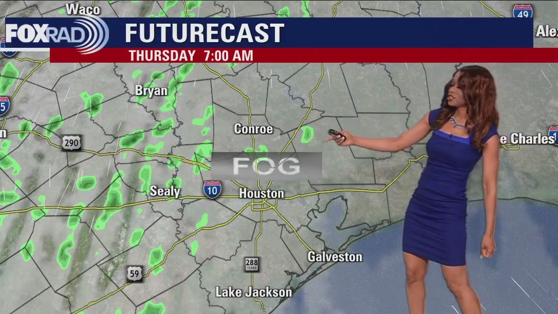

Thursday morning Houston-area weather forecast
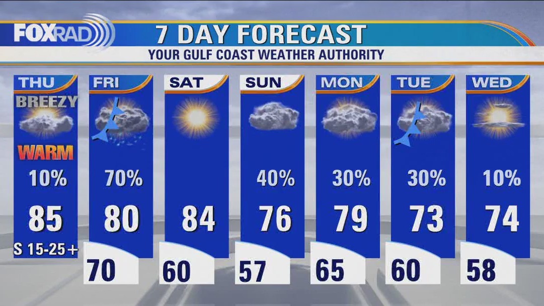
Warm, humid and muggy weather will stick around for the next few days with just a slim shot for an isolated, mainly light rain shower. Afternoon high temperatures should soar to the 80s Thursday and around 80 Friday. Our next storm system moves in on Friday bringing a round of showers and thunderstorms with the best chance during the afternoon. Our threat for severe weather has increased a bit to a category 1 out of 5 on Friday with a few strong, possibly damaging wind gusts near or over 60 mph possible.
Warm, humid and muggy weather will stick around for the next few days with just a slim shot for an isolated, mainly light rain shower. Afternoon high temperatures should soar to the 80s Thursday and around 80 Friday. Our next storm system moves in on Friday bringing a round of showers and thunderstorms with the best chance during the afternoon. Our threat for severe weather has increased a bit to a category 1 out of 5 on Friday with a few strong, possibly damaging wind gusts near or over 60 mph possible.

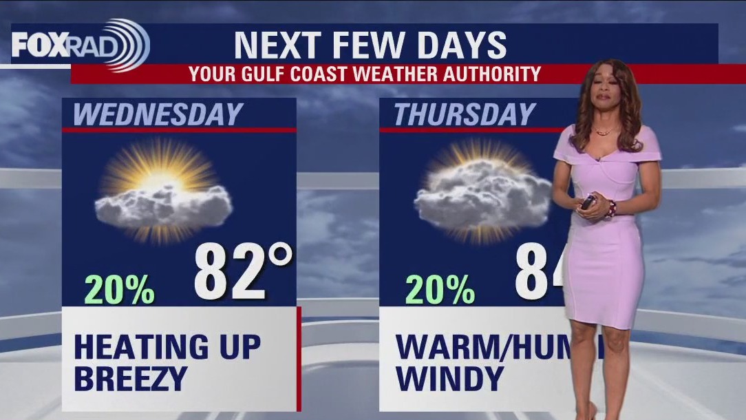
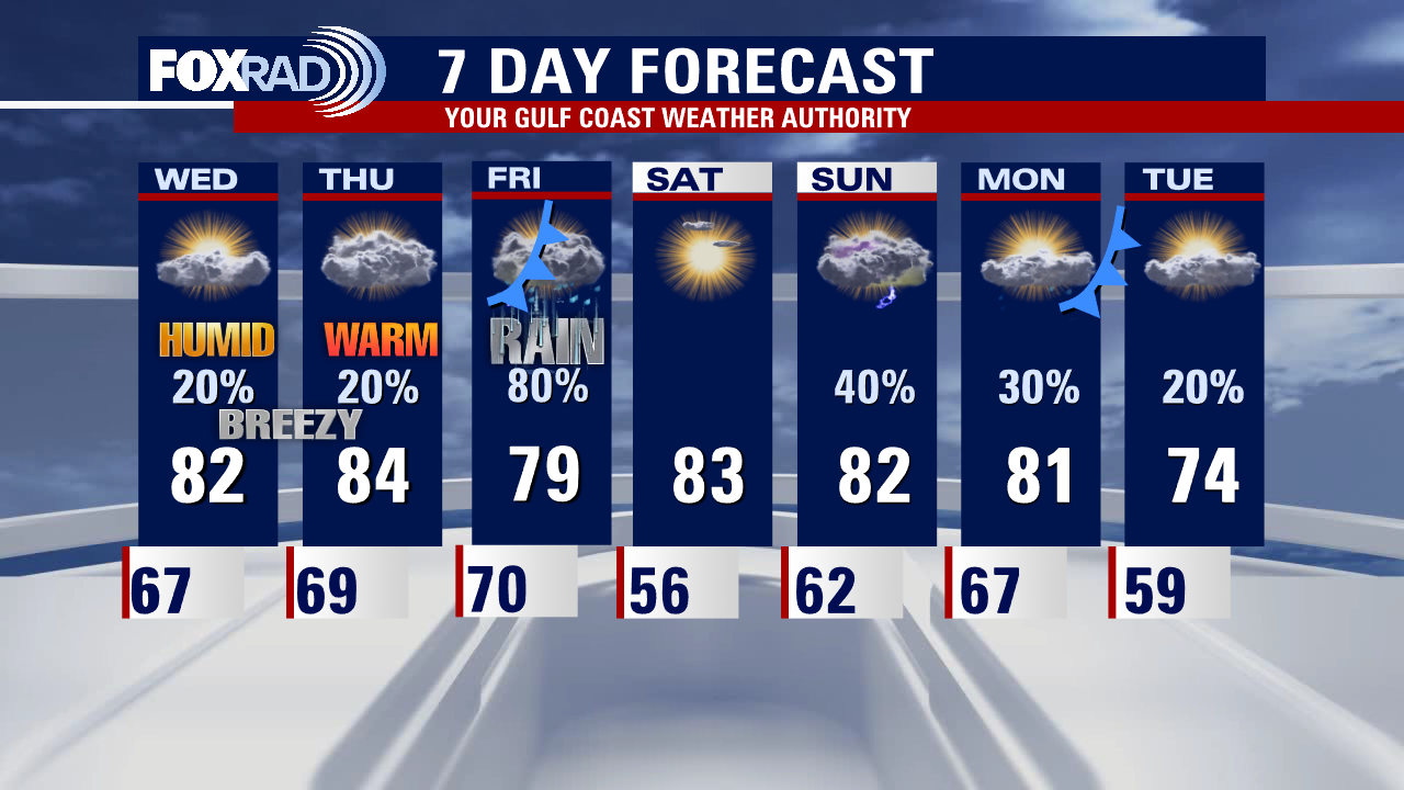
Wednesday evening weather forecast with Meteorologist Remeisha Shade
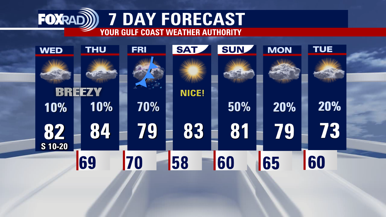
Warm, humid and muggy weather will stick around for the next few days with just a slim shot for an isolated, mainly light rain shower. Afternoon high temperatures should soar to the 80s Thursday and around 80 Friday. Our next storm system moves in on Friday bringing a round of showers and thunderstorms with the best chance during the afternoon. Our threat for severe weather has increased a bit to a category 1 out of 5 on Friday with a few strong, possibly damaging wind gusts near or over 60 mph possible. Saturday weather looks perfect for outdoor plans with warm temperatures and plenty of sun. A warm front will bring scattered storms back to the area on Sunday with lower rain chances lingering Monday and Tuesday. Temps turn slightly cooler behind another cold front Tuesday.
Warm, humid and muggy weather will stick around for the next few days with just a slim shot for an isolated, mainly light rain shower. Afternoon high temperatures should soar to the 80s Thursday and around 80 Friday. Our next storm system moves in on Friday bringing a round of showers and thunderstorms with the best chance during the afternoon. Our threat for severe weather has increased a bit to a category 1 out of 5 on Friday with a few strong, possibly damaging wind gusts near or over 60 mph possible. Saturday weather looks perfect for outdoor plans with warm temperatures and plenty of sun. A warm front will bring scattered storms back to the area on Sunday with lower rain chances lingering Monday and Tuesday. Temps turn slightly cooler behind another cold front Tuesday.

Wednesday afternoon weather forecast with Meteorologist Lena Maria Arango
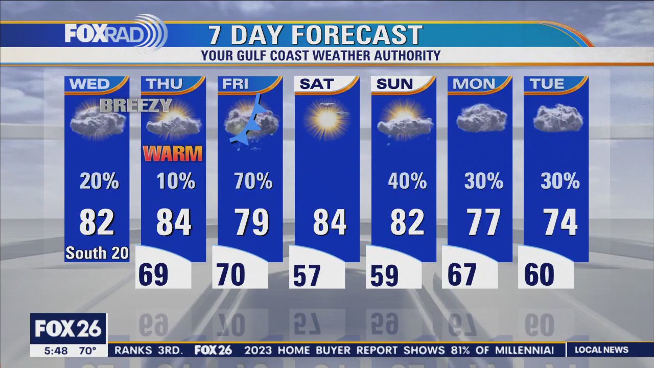
Today and tomorrow will be warm and muggy with a few light drizzles/rain showers. Look for gusty south winds, that should limit widespread fog potential in the mornings and highs in the low to mid-80s. A cold front will increase rain chances on Friday, with a few stronger storms possible mainly north and east. It will drive in fantastic weather for Saturday, so get those outdoor plans ready for full sunshine and low humidity although temps stay warm! The glory is short-lived, as it lifts back northward as a warm front on Sunday leading to more warm, muggy, cloudy, showery days early next week.
Today and tomorrow will be warm and muggy with a few light drizzles/rain showers. Look for gusty south winds, that should limit widespread fog potential in the mornings and highs in the low to mid-80s. A cold front will increase rain chances on Friday, with a few stronger storms possible mainly north and east. It will drive in fantastic weather for Saturday, so get those outdoor plans ready for full sunshine and low humidity although temps stay warm! The glory is short-lived, as it lifts back northward as a warm front on Sunday leading to more warm, muggy, cloudy, showery days early next week.
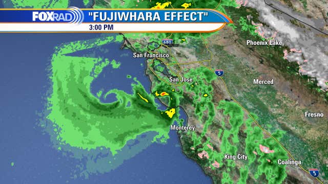

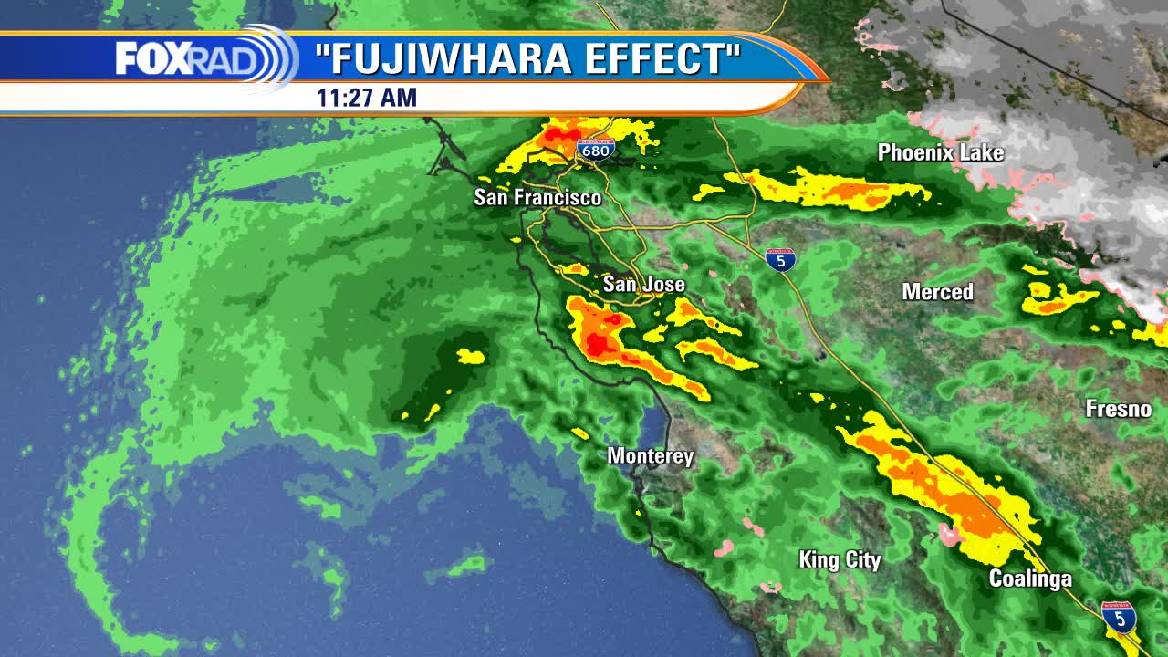
Fujiwhara Effect: Powerful storm system hitting California causes rare occurrence
The Fujiwhara Effect was first described by Japanese meteorologist Sakuhei Fujiwhara in the 1920s. He predicted that two cyclones, such as typhoons, will rotate or orbit around each other in a counter-clockwise direction.
The Fujiwhara Effect was first described by Japanese meteorologist Sakuhei Fujiwhara in the 1920s. He predicted that two cyclones, such as typhoons, will rotate or orbit around each other in a counter-clockwise direction.

Powerful storm system hitting California causes Fujiwhara Effect
The Fujiwhara Effect has been observed many times with typhoons in the Pacific Ocean, but is extremely rare with small circulations like those pictures here near San Francisco.
The Fujiwhara Effect has been observed many times with typhoons in the Pacific Ocean, but is extremely rare with small circulations like those pictures here near San Francisco.


America's first-ever tornado forecast issued 75 years ago at Oklahoma's Tinker Air Force Base
An unusual pair of tornadoes that struck an Oklahoma Air Force base in March 1948 paved the way for severe weather forecasting as we know it today.
An unusual pair of tornadoes that struck an Oklahoma Air Force base in March 1948 paved the way for severe weather forecasting as we know it today.

Houston weather: Warming trend kicks in
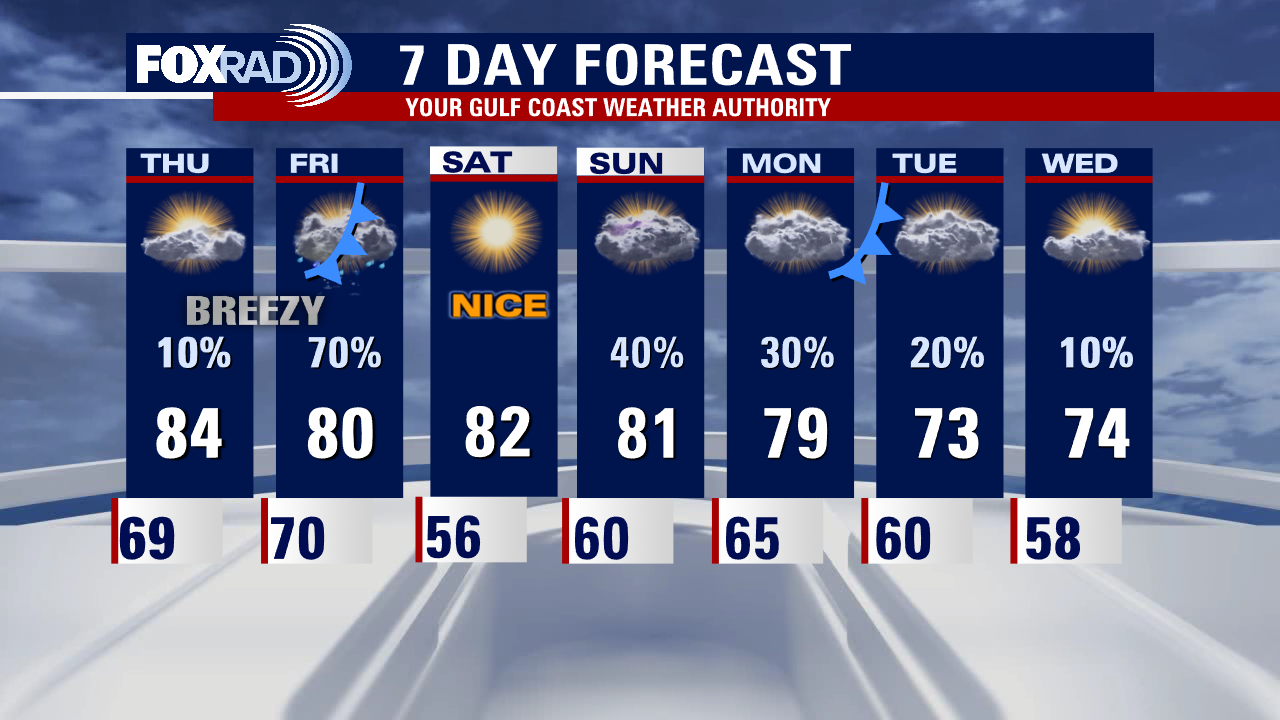
A warming trend has kicked in and a muggy south breeze will allow afternoon highs to reach the low and mid 80s today and Thursday. A storm system in California will slide north of our area bringing a good chance for showers and a few strong storms followed by sunny, dry weather for Saturday. The pattern for early next week looks showery.
A warming trend has kicked in and a muggy south breeze will allow afternoon highs to reach the low and mid 80s today and Thursday. A storm system in California will slide north of our area bringing a good chance for showers and a few strong storms followed by sunny, dry weather for Saturday. The pattern for early next week looks showery.

Tuesday morning Houston-area weather forecast
After a brief return to winter weather, we are back to feeling like spring on this first full day of spring 2023! The heat and humidity are increasing along with wind out of the south. It will stay breezy the next few days but get warmer Wednesday and Thursday as temperatures soar into the 80s. Other than a few light rain showers, weather should be mostly dry through Thursday. Next cold front arrives on Friday and will bring a decent round of rain and a few storms Friday morning through the afternoon.
After a brief return to winter weather, we are back to feeling like spring on this first full day of spring 2023! The heat and humidity are increasing along with wind out of the south. It will stay breezy the next few days but get warmer Wednesday and Thursday as temperatures soar into the 80s. Other than a few light rain showers, weather should be mostly dry through Thursday. Next cold front arrives on Friday and will bring a decent round of rain and a few storms Friday morning through the afternoon.

Tuesday evening weather forecast with Meteorologist Remeisha Shade
After a brief return to winter weather, we are back to feeling like spring on this first full day of spring 2023! The heat and humidity are increasing along with wind out of the south. It will stay breezy the next few days but get warmer Wednesday and Thursday as temperatures soar into the 80s. Other than a few light rain showers, the weather should be mostly dry through Thursday. The next cold front arrives on Friday and will bring a decent round of rain and a few storms Friday morning through the afternoon. A few storms could be strong but right now the main threat for severe storms is expected to be to our E/NE. Friday's front will bring a slight cooldown Friday night as we drop to the 50s. But we are back to the 80s for the weekend with spotty showers and storms returning Sunday. Enjoy the rest of your week and make sure to grab the FOX 26 weather app from the app store!
After a brief return to winter weather, we are back to feeling like spring on this first full day of spring 2023! The heat and humidity are increasing along with wind out of the south. It will stay breezy the next few days but get warmer Wednesday and Thursday as temperatures soar into the 80s. Other than a few light rain showers, the weather should be mostly dry through Thursday. The next cold front arrives on Friday and will bring a decent round of rain and a few storms Friday morning through the afternoon. A few storms could be strong but right now the main threat for severe storms is expected to be to our E/NE. Friday's front will bring a slight cooldown Friday night as we drop to the 50s. But we are back to the 80s for the weekend with spotty showers and storms returning Sunday. Enjoy the rest of your week and make sure to grab the FOX 26 weather app from the app store!