


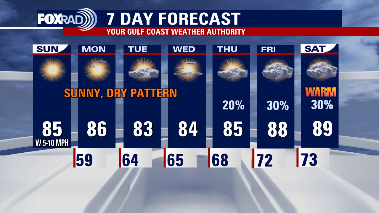
Houston weather: Sunny, dry weather expected for beginning of work week
The workweek forecast for Southeast Texas calls for seasonal temperatures with no rain at the start. By the time we get to the end, warmer temps and chances of rain start to creep into the Houston area.
The workweek forecast for Southeast Texas calls for seasonal temperatures with no rain at the start. By the time we get to the end, warmer temps and chances of rain start to creep into the Houston area.


Houston weather: Sunny, breezy Sunday evening with temps in the 80s
The workweek forecast fore Southeast Texas calls for seasonal temperatures with no rain at the start. By the time we get to the end, warmer temps and chances of rain start to creep into the Houston area.
The workweek forecast fore Southeast Texas calls for seasonal temperatures with no rain at the start. By the time we get to the end, warmer temps and chances of rain start to creep into the Houston area.


El Tiempo 30 de Abril de 2023
#FOX26 Meteor?loga Lena Maria Arango tiene su pron?stico para la semana laboral.
#FOX26 Meteor?loga Lena Maria Arango tiene su pron?stico para la semana laboral.

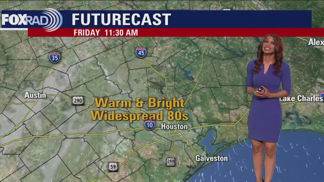
Sunday weather forecast with Meteorologist Lena Maria Arango
We'll kick off this week with a beautiful stretch of dry, mostly sunny weather and light winds. Enjoy it because by midweek, the humidity will be on the rise, and muggy, warm mornings return. Rain chances will also increase as daytime highs climb their way to near 90 by the weekend. The overall pattern looks unsettled for next week.
We'll kick off this week with a beautiful stretch of dry, mostly sunny weather and light winds. Enjoy it because by midweek, the humidity will be on the rise, and muggy, warm mornings return. Rain chances will also increase as daytime highs climb their way to near 90 by the weekend. The overall pattern looks unsettled for next week.


Suspected tornado flips cars, leaves damage trail in South Florida as storms race across state
The first round of storms triggered severe weather warnings and likely produced a tornado in northern Palm Beach County on Saturday.
The first round of storms triggered severe weather warnings and likely produced a tornado in northern Palm Beach County on Saturday.

Cloudy, cool, and breezy Saturday evening in the 60s
Southeast Texas is set up for a break from the rain over the next several days. Afternoon high temperatures for the start of May in Houston are normally in the lower 80s and that's what the forecast calls for headed into this week. Look for slight rain chances to come back at the end of the week.
Southeast Texas is set up for a break from the rain over the next several days. Afternoon high temperatures for the start of May in Houston are normally in the lower 80s and that's what the forecast calls for headed into this week. Look for slight rain chances to come back at the end of the week.

Saturday weather forecast with Meteorologist Lena Maria Arango
Rain is moving out but gusty winds will be with us with a wind advisory in effect through 8 p.m. For those riding the MS 150 Houston to La Grange, it will be a headwind making for a bit of a challenging ride. Locally, plan for decreasing clouds but a cool day where most of us may not make it out of the 60s/lower 70s at best. But, come tomorrow a sunny, dry, warm trend emerges with rain likely not returning until the end of next week!
Rain is moving out but gusty winds will be with us with a wind advisory in effect through 8 p.m. For those riding the MS 150 Houston to La Grange, it will be a headwind making for a bit of a challenging ride. Locally, plan for decreasing clouds but a cool day where most of us may not make it out of the 60s/lower 70s at best. But, come tomorrow a sunny, dry, warm trend emerges with rain likely not returning until the end of next week!


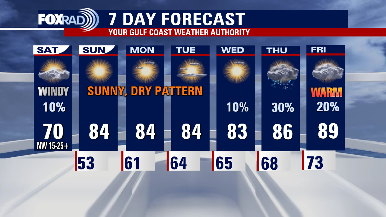
Houston-area weather forecast: Rain moving out on Saturday, expect windy conditions
Look for rain and a few rumbles of thunder through Saturday morning with most of the rain fading by late Saturday afternoon. It will be WINDY Saturday for the MS 150 Bike Ride with NW winds of 15-25 mph and gusts near 35 mph! Wind should settle down Sunday with lots of sunshine. Next week looks warm with only small rain chances returning mid-late week.
Look for rain and a few rumbles of thunder through Saturday morning with most of the rain fading by late Saturday afternoon. It will be WINDY Saturday for the MS 150 Bike Ride with NW winds of 15-25 mph and gusts near 35 mph! Wind should settle down Sunday with lots of sunshine. Next week looks warm with only small rain chances returning mid-late week.

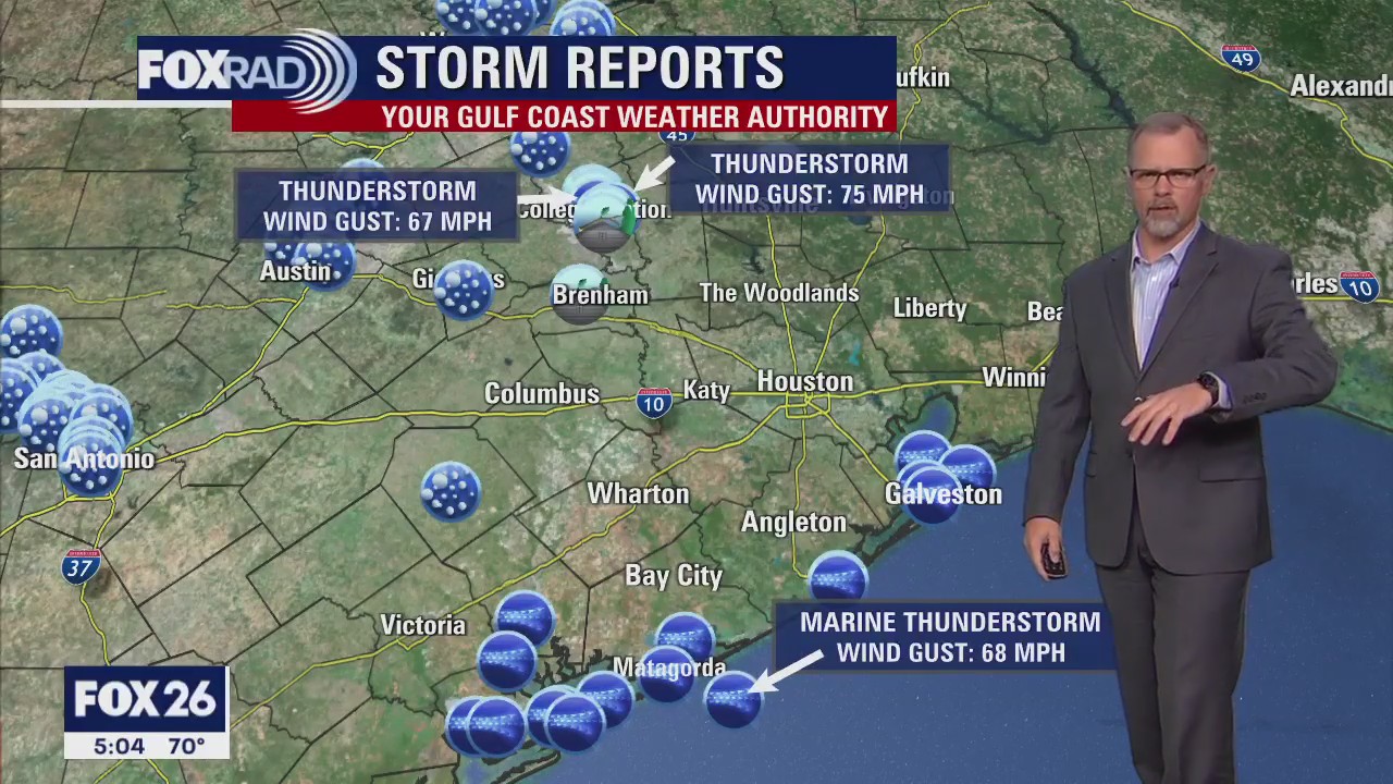
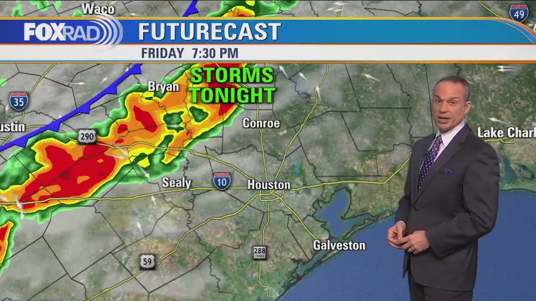
Houston-area weather forecast: Strong storms possible Friday night, clearing out on Saturday
Severe Thunderstorm Watch is in effect for counties west of Houston including Grimes, Washington, Austin, Waller & Colorado until 10 PM. Wind gusts to 70 MPH along with quarter to golf ball size hail remain possible in a few of these storms. Storms are expected to weaken as they try to push into Houston tonight. Main window for the severe weather will be 6-10 PM and main location will be west of Houston. Look for rain and a few rumbles of thunder through Saturday morning with most of the rain fading by late Saturday afternoon. It will be WINDY Saturday for the MS 150 Bike Ride with NW winds of 15-25 mph and gusts near 35 mph! Wind should settle down Sunday with lots of sunshine. Next week looks warm with only small rain chances returning mid-late week.
Severe Thunderstorm Watch is in effect for counties west of Houston including Grimes, Washington, Austin, Waller & Colorado until 10 PM. Wind gusts to 70 MPH along with quarter to golf ball size hail remain possible in a few of these storms. Storms are expected to weaken as they try to push into Houston tonight. Main window for the severe weather will be 6-10 PM and main location will be west of Houston. Look for rain and a few rumbles of thunder through Saturday morning with most of the rain fading by late Saturday afternoon. It will be WINDY Saturday for the MS 150 Bike Ride with NW winds of 15-25 mph and gusts near 35 mph! Wind should settle down Sunday with lots of sunshine. Next week looks warm with only small rain chances returning mid-late week.
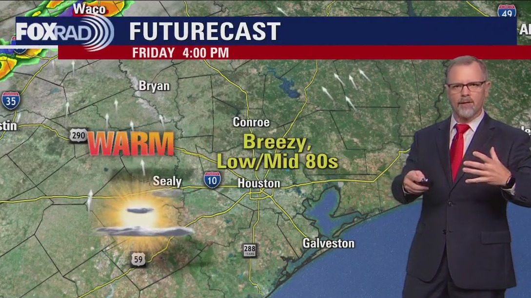

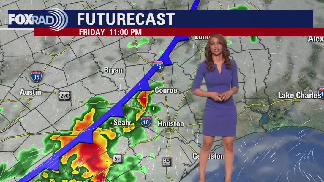
Warm, breezy Friday afternoon in the 70s, storms expected in the evening
Warm and breezy for Friday afternoon in Houston but storms are moving through the Lone Star State and headed to Southeast Texas. A line of potentially severe storms arrives between about 8 p.m. and 2 a.m.Windy, cool, and dry conditions are expected for the start of the Texas MS 150 ride on Saturday morning. High temperatures on Saturday will be only around 70 but a warming trend starts on Sunday.
Warm and breezy for Friday afternoon in Houston but storms are moving through the Lone Star State and headed to Southeast Texas. A line of potentially severe storms arrives between about 8 p.m. and 2 a.m.Windy, cool, and dry conditions are expected for the start of the Texas MS 150 ride on Saturday morning. High temperatures on Saturday will be only around 70 but a warming trend starts on Sunday.

Houston weather: Cool Friday morning with patchy fog, temps warming in the afternoon
Today's weather looks terrific, but don't let your guard down because some strong storms are expected tonight. We'll transition from a sunny, breezy, and warm afternoon to a line of potentially severe line of storms between about 8 pm and 2 am. Windy, cool, and dry weather kicks in on Saturday (strong headwinds for the MS150 ride) with highs near 70. A warming trend begins Sunday afternoon through next week.
Today's weather looks terrific, but don't let your guard down because some strong storms are expected tonight. We'll transition from a sunny, breezy, and warm afternoon to a line of potentially severe line of storms between about 8 pm and 2 am. Windy, cool, and dry weather kicks in on Saturday (strong headwinds for the MS150 ride) with highs near 70. A warming trend begins Sunday afternoon through next week.

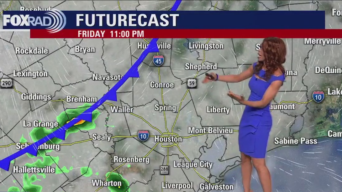
Houston area weather: Another stormy night could be on the way Friday
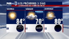
During the day Friday, it will be bright and beautiful with lots of sun and warm temperatures soaring to the middle 80s. But another strong storm system is set to bring parts of the state another round of strong to severe storms. This system should roll into our area Friday night and Saturday. Initially, a round of strong storms will be possible between around 8PM Friday and 1 AM Saturday. The best chance will be west of I-45. Then look for cooler temperatures & rounds of rain Saturday morning becoming less widespread by Saturday PM. Sunday still looks great for weekend outdoor plans with some sunshine and temperatures near 80. Next week is looking warmer with more dry time to get outside and enjoy.
During the day Friday, it will be bright and beautiful with lots of sun and warm temperatures soaring to the middle 80s. But another strong storm system is set to bring parts of the state another round of strong to severe storms. This system should roll into our area Friday night and Saturday. Initially, a round of strong storms will be possible between around 8PM Friday and 1 AM Saturday. The best chance will be west of I-45. Then look for cooler temperatures & rounds of rain Saturday morning becoming less widespread by Saturday PM. Sunday still looks great for weekend outdoor plans with some sunshine and temperatures near 80. Next week is looking warmer with more dry time to get outside and enjoy.

Houston weather: Warm temps in the 70s Thursday evening, few foggy areas
A quiet night is expected with SE Texas remaining in between storm systems. It should be pleasant and dry with temperatures dipping into the 50s and 60s. There's a small chance of a little fog late tonight. During the day Friday, it will be bright and beautiful with lots of sun and warm temperatures soaring to the middle 80s. But another strong storm system is set to bring parts of the state another round of strong to severe storms. This system should roll into our area Friday night and Saturday. Initially, a round of strong storms will be possible between around 8PM Friday and 1 AM Saturday. The best chance will be west of I-45. Then look for cooler temperatures & rounds of rain Saturday morning becoming less widespread by Saturday PM. Sunday still looks great for weekend outdoor plans with some sunshine and temperatures near 80. Next week is looking warmer with more dry time to get outside and enjoy.
A quiet night is expected with SE Texas remaining in between storm systems. It should be pleasant and dry with temperatures dipping into the 50s and 60s. There's a small chance of a little fog late tonight. During the day Friday, it will be bright and beautiful with lots of sun and warm temperatures soaring to the middle 80s. But another strong storm system is set to bring parts of the state another round of strong to severe storms. This system should roll into our area Friday night and Saturday. Initially, a round of strong storms will be possible between around 8PM Friday and 1 AM Saturday. The best chance will be west of I-45. Then look for cooler temperatures & rounds of rain Saturday morning becoming less widespread by Saturday PM. Sunday still looks great for weekend outdoor plans with some sunshine and temperatures near 80. Next week is looking warmer with more dry time to get outside and enjoy.

El Tiempo 27 de Abril de 2023
FOX26 Meteor?loga Lena Maria Arango tiene su pron?stico para el fin de semana.
FOX26 Meteor?loga Lena Maria Arango tiene su pron?stico para el fin de semana.

Houston weather: Slightly cloudy on Thursday afternoon, warm temps in the 70s
Clouds will gradually decrease throughout the day today, leading to completely clear skies by Friday morning. After a cool start, we'll warm into the low-mid 80s as we brace for our next round for rain. Plan for isolated to scattered showers and storms from late Friday through early Saturday. Next week looks mostly pleasant and dry, with a gradual warming trend.
Clouds will gradually decrease throughout the day today, leading to completely clear skies by Friday morning. After a cool start, we'll warm into the low-mid 80s as we brace for our next round for rain. Plan for isolated to scattered showers and storms from late Friday through early Saturday. Next week looks mostly pleasant and dry, with a gradual warming trend.


Houston weather: Temperatures return to the mid-80s after cool, rainy Thursday
After a round of heavy morning rain, we will gradually clear for the afternoon with highs near 80 degrees.
After a round of heavy morning rain, we will gradually clear for the afternoon with highs near 80 degrees.

Houston Weather: Sunshine returns Friday after cloudy Thursday
After a round of heavy morning rain, we will gradually clear for the afternoon with highs near 80. Tonight will feel pleasant, but with a chance for some fog. Sunshine could allow us to hit the mid-80s on Friday, but another front is on the way for Saturday bringing cooler air and another round of rain. Next week looks very warm.
After a round of heavy morning rain, we will gradually clear for the afternoon with highs near 80. Tonight will feel pleasant, but with a chance for some fog. Sunshine could allow us to hit the mid-80s on Friday, but another front is on the way for Saturday bringing cooler air and another round of rain. Next week looks very warm.

Houston-area weather forecast: Stormy morning possible, decreasing clouds in the afternoon
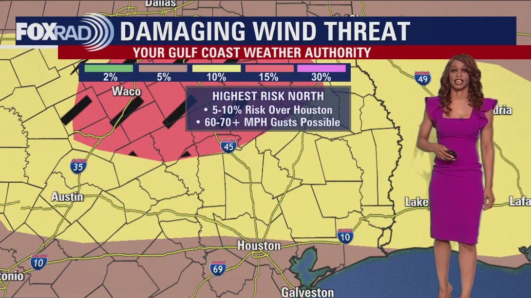
Models are showing more showers and storms around 4-6 AM and another possible round by 8-9 AM just ahead of the cold front. Severe risk tonight is highest in our northern counties at 2/5 with a 1/5 threat in the southern areas. Large hail, 60-70 MPH winds and heavy downpours will be the main threats. However, there is a 2-5% tornado threat as well so stay alert! We should dry out behind the front Thursday afternoon and evening. Friday looks bright and lovely but Saturday is trending wetter. Look for a decent shot for rain for a big chunk of Saturday, winding down early Sunday. Make sure to keep track of all the changing weather by downloading the FOX 26 Weather App on your phone!
Models are showing more showers and storms around 4-6 AM and another possible round by 8-9 AM just ahead of the cold front. Severe risk tonight is highest in our northern counties at 2/5 with a 1/5 threat in the southern areas. Large hail, 60-70 MPH winds and heavy downpours will be the main threats. However, there is a 2-5% tornado threat as well so stay alert! We should dry out behind the front Thursday afternoon and evening. Friday looks bright and lovely but Saturday is trending wetter. Look for a decent shot for rain for a big chunk of Saturday, winding down early Sunday. Make sure to keep track of all the changing weather by downloading the FOX 26 Weather App on your phone!

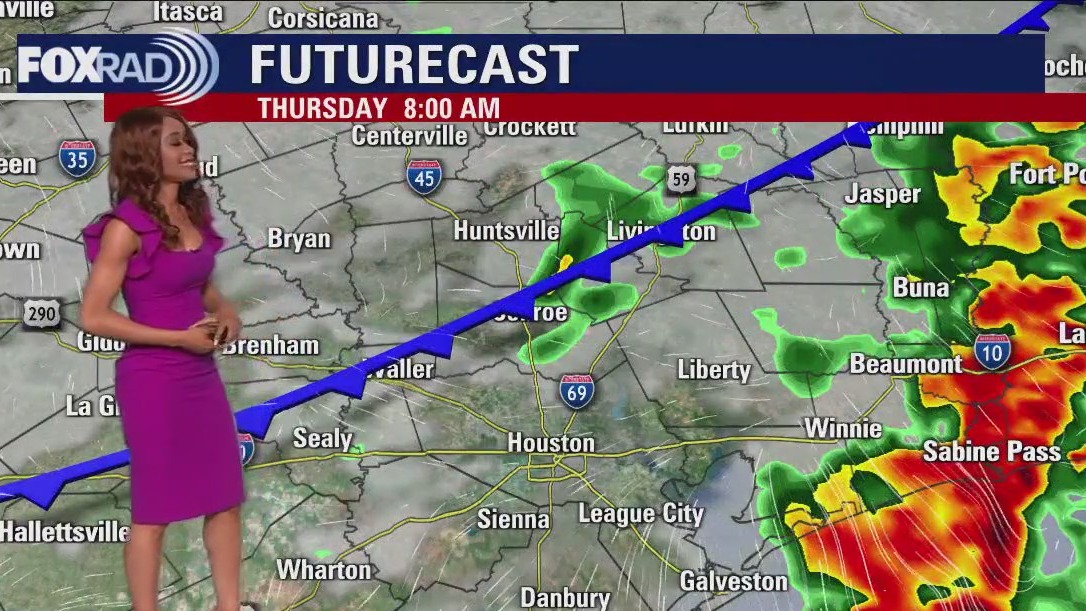
Houston weather: Storms likely Wednesday evening, early Thursday morning
Threat for severe weather will increase late tonight and stick around through early Thursday morning for much of SE Texas. Main window for strong to severe storms will be from 10PM tonight until 7AM Thursday. Strong to severe storms are expected to build in around 10-11 PM tonight from the north rolling into Huntsville & Livingston. Then by Midnight - 1 AM, rain and storms should drop into the Houston area. Models are showing more showers and storms around 4-6 AM and another possible round by 8-9 AM just ahead of the cold front. Severe risk tonight is highest in our northern counties at 2/5 with a 1/5 threat in the southern areas. Large hail, 60-70 MPH winds and heavy downpours will be the main threats. However, there is a 2-5% tornado threat as well so stay alert! We should dry out behind the front Thursday afternoon and evening. Friday looks bright and lovely but Saturday is trending wetter. Look for a decent shot for rain for a big chunk of Saturday, winding down early Sunday. Make sure to keep track of all the changing weather by downloading the FOX 26 Weather App on your phone!
Threat for severe weather will increase late tonight and stick around through early Thursday morning for much of SE Texas. Main window for strong to severe storms will be from 10PM tonight until 7AM Thursday. Strong to severe storms are expected to build in around 10-11 PM tonight from the north rolling into Huntsville & Livingston. Then by Midnight - 1 AM, rain and storms should drop into the Houston area. Models are showing more showers and storms around 4-6 AM and another possible round by 8-9 AM just ahead of the cold front. Severe risk tonight is highest in our northern counties at 2/5 with a 1/5 threat in the southern areas. Large hail, 60-70 MPH winds and heavy downpours will be the main threats. However, there is a 2-5% tornado threat as well so stay alert! We should dry out behind the front Thursday afternoon and evening. Friday looks bright and lovely but Saturday is trending wetter. Look for a decent shot for rain for a big chunk of Saturday, winding down early Sunday. Make sure to keep track of all the changing weather by downloading the FOX 26 Weather App on your phone!