


Watch: Lee's monstrous eyewall captured by Hurricane Hunters in electric video
Hurricane Hunter footage from the eye of Hurricane Lee shows the surreal scene of massive storm clouds towering around a calm eye amid darkness.


FOX 26 Houston Weather Forecast
Chief Meteorologist Mike Iscovitz has the forecast for Friday.


Tropical Weather Forecast - September 7, 2023
Hurricane Lee has blown up to a major Category 4 hurricane in the central Atlantic and is expected to reach a dangerous and powerful Category 5 hurricane by Friday. Rip currents and hazardous surf will spread across the northern Caribbean Islands the next few days. Lee could bring some impacts to parts of the Bahamas and the east coast of the US next week but should stay over open water for at least the next 5 days. Tropical Storm Margot has also formed in the eastern Atlantic and is forecast to become a hurricane by this weekend.
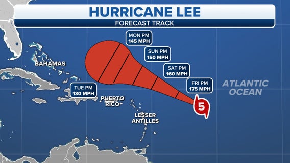

Hurricane Lee rapidly intensifies to extremely dangerous Category 5 storm as it barrels through the Atlantic
Hurricane Lee is undergoing rapid intensification and reached Category 5 status on Thursday evening.


FOX 26 Thursday evening weather forecast
Air Quality Alert has been extended through Friday evening for higher ozone levels and a Heat Advisory is in effect through 9 PM this evening. Heat Index values could approach 112 so be careful as you enjoy time outside! Some changes are on the way though with a few strong to severe storms possible Friday PM. Best chance will be NE of Houston from around 3-9 PM. Our best chance for rain appears to come Saturday where we could get two rounds of showers and storms. one in the morning and another in the afternoon. This could mean some beneficial rain and drought relief. Look for one more day of record setting heat before temperatures gradually start to cool off as we go through next week. Rain chances will also stick around for much of next week as well.


El Tiempo 7 de Septiembre de 2023
#FOX26 Meteor?loga Lena Maria Arango tiene su pron?stico para el fin de semana.


FOX 26 Houston Weather Forecast
A heat advisory is in effect. Mostly sunny, hot and humid with highs above 100.


FOX 26 Houston Weather Forecast
Another Heat Advisory will be in place from 1-9 pm Thursday. Heat index values up to 112 will remain possible during this time. Air Quality Alert has also been issued for Houston for Thursday for higher levels of ozone. Temperatures the next few days will likely climb to triple digits with very isolated rain. Temperatures are expected to drop a bit this weekend and next week with a few more showers and storms around. Lee has become a hurricane in the central Atlantic but should stay away from the Caribbean and Gulf of Mexico. However, some impacts could be felt for the Lesser Antilles & Puerto Rico by this weekend.

Hurricane Lee forms, expected to rapidly intensify into 'extremely dangerous' major storm by weekend
Hurricane Lee continues to gain strength as it churns west in the Atlantic Ocean, forecast to reach at least Category 4 strength by the weekend as it brushes past the northern Leeward Islands.


FOX 26 Wednesday evening weather forecast
Heat Advisory remains in effect until 9 pm for the Houston area. Another Heat Advisory will be in place from 1-9 pm Thursday. Heat index values up to 112 will remain possible during this time. Air Quality Alert has also been issued for Houston for Thursday for higher levels of ozone. Temperatures the next few days will likely climb to triple digits with very isolated rain. Temperatures are expected to drop a bit this weekend and next week with a few more showers and storms around. Lee has become a hurricane in the central Atlantic but should stay away from the Caribbean and Gulf of Mexico. However, some impacts could be felt for the Lesser Antilles & Puerto Rico by this weekend.


Tropical Weather Forecast - September 6, 2023
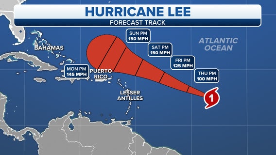
Lee is now a Category 1 hurricane and is expected to become a very dangerous major hurricane by Friday. Lee should stay north of the Caribbean Sea but could bring some impacts to parts of the Lesser Antilles & Puerto Rico by this weekend. Next week hurricane Lee could bring some impacts to the US east coast. But most models have Lee turning north before making a direct landfall on the US east coast. Another strong Tropical wave in the far east Atlantic still has a good shot to become a Tropical Depression or Tropical Storm over the next 7 days. Gulf of Mexico remains quiet for now.


This summer was a global record breaker for highest heat ever calculated, meteorologists say
So far, 2023 is the second-hottest year on record, behind 2016, experts say.


Information theft on the rise. People are especially vulnerable after natural disasters
Scammers may pretend to be from a utility company or the Federal Emergency Management Agency and ask an unsuspecting person to "verify information."


FOX 26 Houston Weather Forecast
A late-season heat dome will help us hit record highs today in Houston. Today's daily record is just 99? for Houston and only 97? for Hobby airport, so both of those could be broken. Watch for isolated afternoon storms today with the main story being the heat through Friday. This weekend, rain chances rise, so temps could be held into the 90s.


FOX 26 Houston Weather Forecast
Heat Advisory remains in effect until 9pm for Houston and surrounding areas. Heat index values up to 110 are possible through this evening. Look for more heat alerts possible this week along with temperatures likely reaching triple digits for many areas Wednesday through Friday. Isolated rain is possible Wednesday afternoon with rain chances returning again this weekend. Tropical Storm Lee has formed in the central Atlantic and is forecast to become a major hurricane late this week as it nears the Lesser Antilles & Puerto Rico.


Tropical Weather Forecast - September 5, 2023
Tropical Depression #13 is now Tropical Storm Lee in the central Atlantic. It is forecast to become a Category 1 hurricane by Thursday. It is expected to become a major hurricane by Friday as it crosses just north of the Lesser Antilles & Puerto Rico. This system will need to be monitored closely as it could make it all the way to the east coast of the US next week. Another strong tropical wave has pushed off the west coast of Africa and has a high chance to become a Tropical Depression or Tropical Storm over the next 7 days. The remnants of Franklin in the NE Atlantic only has a slim shot to redevelop at this time.


FOX 26 Tuesday morning weather forecast
Despite downpours yesterday, we marked our 56th straight day above average and that trend will continue today through at least Friday. Watch for scattered afternoon storms today, isolated rain tomorrow and another chance for showers on Saturday.


FOX 26 Houston Weather Forecast
Spotty to scattered showers & storms have greeted us for this Labor Day Monday with a few heavy downpours lingering through sunset. We'll do this again for Tuesday with a 40% chance for showers and storms. Then rain chances fall off to 20% for Wednesday and don't return again until the weekend. Temperatures are hot in the upper 90s the next few days with more 100 degree heat Thursday & Friday. Remember if you hear thunder or see lightning, try to head indoors!