


Houston residents deal with SWELTERING heat
A Heat Advisory has been issued for south central and southeast Texas, including Houston. FOX 26's Jonathan Mejia reports on how people are staying cool despite sweltering conditions.
A Heat Advisory has been issued for south central and southeast Texas, including Houston. FOX 26's Jonathan Mejia reports on how people are staying cool despite sweltering conditions.

FOX 26 Houston Weather Forecast
The Heat Advisories continue for Southeast Texas, now through at least Sunday evening. Use caution working or playing outdoors from Noon until 7 p.m. An isolated shower/storm is possible but not many will find their way across the Houston area. Sahara dust moves along the Texas coast Sunday through Tuesday bringing hazy skies along with some beautiful sunrises and sunsets.
The Heat Advisories continue for Southeast Texas, now through at least Sunday evening. Use caution working or playing outdoors from Noon until 7 p.m. An isolated shower/storm is possible but not many will find their way across the Houston area. Sahara dust moves along the Texas coast Sunday through Tuesday bringing hazy skies along with some beautiful sunrises and sunsets.

Tropical update: Hurricane Beryl forms in Atlantic
Beryl is now a hurricane and is expected to become a major hurricane as it moves into and through the Caribbean Sea. Invest 94L could have some major impacts on Mexico and the tropical wave off the African coast is to be watched closely for development.
Beryl is now a hurricane and is expected to become a major hurricane as it moves into and through the Caribbean Sea. Invest 94L could have some major impacts on Mexico and the tropical wave off the African coast is to be watched closely for development.

Heat Advisory issued for Houston area until June 30
A heat advisory has been issued for the Houston area for the weekend as heat index values are expected to reach up to 112.
A heat advisory has been issued for the Houston area for the weekend as heat index values are expected to reach up to 112.

Tropical Storm Beryl could become hurricane
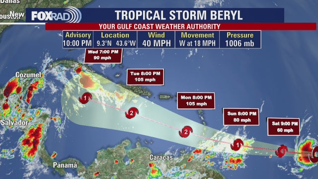
FOX 26 Meteorologist Allison Gargaro discusses Tropical Storm Beryl which developed in the Atlantic late Friday night and now has the chance of becoming a Category 3 Hurricane next week in the Caribbean Sea.
FOX 26 Meteorologist Allison Gargaro discusses Tropical Storm Beryl which developed in the Atlantic late Friday night and now has the chance of becoming a Category 3 Hurricane next week in the Caribbean Sea.

Tropical Storm Beryl forms in Atlantic, forecast to become hurricane
More than 3,000 miles from Houston, Tropical Storm Beryl has formed in the Atlantic Ocean, with a slight chance of reaching the Gulf some time next week.
More than 3,000 miles from Houston, Tropical Storm Beryl has formed in the Atlantic Ocean, with a slight chance of reaching the Gulf some time next week.

FOX 26 Houston Weather Forecast
It's still June but the deep summer heat is all across Southeast Texas. This weekend looks like a typical "August" weekend in Houston. Isolated storms are possible for Saturday but don't look for many to provide temporary cool-downs. Saharan dust moves in from the Gulf bringing hazy skies as temps continue to hover just below the triple digits. Most of the FOX26 area is under a Heat Advisory Saturday.
It's still June but the deep summer heat is all across Southeast Texas. This weekend looks like a typical "August" weekend in Houston. Isolated storms are possible for Saturday but don't look for many to provide temporary cool-downs. Saharan dust moves in from the Gulf bringing hazy skies as temps continue to hover just below the triple digits. Most of the FOX26 area is under a Heat Advisory Saturday.

FOX 26 Houston Weather Forecast
It's still June but the deep summer heat is all across Southeast Texas. This weekend looks like a typical "August" weekend in Houston. Isolated storms are possible for Saturday but don't look for many to provide temporary cool-downs. Saharan dust moves in from the Gulf bringing hazy skies as temps continue to hover just below the triple digits. Most of the FOX26 area is under a Heat Advisory Saturday.
It's still June but the deep summer heat is all across Southeast Texas. This weekend looks like a typical "August" weekend in Houston. Isolated storms are possible for Saturday but don't look for many to provide temporary cool-downs. Saharan dust moves in from the Gulf bringing hazy skies as temps continue to hover just below the triple digits. Most of the FOX26 area is under a Heat Advisory Saturday.

Tropical Update: Expecting named tropical storm
Invest 95L has a new number and that is "two", as in Tropical Depression Two. We are still expecting this system to be named Beryl, but for now the National Hurricane Center is classifying it as a tropical depression. There are also a couple other areas of disturbed weather to discuss in the Atlantic basin.
Invest 95L has a new number and that is "two", as in Tropical Depression Two. We are still expecting this system to be named Beryl, but for now the National Hurricane Center is classifying it as a tropical depression. There are also a couple other areas of disturbed weather to discuss in the Atlantic basin.

Forecasting With Friends: Tracking tropical depression
Meteorologist Allison Gargaro discusses the extreme heat and its impact on your mental health and more on the tropical depression building in the Atlantic with a high chance of becoming a named storm.
Meteorologist Allison Gargaro discusses the extreme heat and its impact on your mental health and more on the tropical depression building in the Atlantic with a high chance of becoming a named storm.

Emergency Gear Test: First Aid Kits
We are in hurricane season, but there are other emergencies that can arise. FOX 26 Meteorologist John Dawson talks about the importance of having a first aid kit.
We are in hurricane season, but there are other emergencies that can arise. FOX 26 Meteorologist John Dawson talks about the importance of having a first aid kit.

Your Gulf Coast Weather Authority
Happy Friday, everyone. Yes, it's going to be another hot, humid day with a heat advisory in effect and afternoon temperatures reaching the mid to upper 90s. Expect some pop-up storms to temporarily cool things down - a similar outlook for Saturday. Beginning Sunday, a plume of Saharan dust could move into Texas bringing some hazy skies as temperatures rise in the mid and upper 90s. In the tropics, a strong tropical wave in the central Atlantic could become a tropical storm over the next few days. It is very far from here, so we have a long time to watch.
Happy Friday, everyone. Yes, it's going to be another hot, humid day with a heat advisory in effect and afternoon temperatures reaching the mid to upper 90s. Expect some pop-up storms to temporarily cool things down - a similar outlook for Saturday. Beginning Sunday, a plume of Saharan dust could move into Texas bringing some hazy skies as temperatures rise in the mid and upper 90s. In the tropics, a strong tropical wave in the central Atlantic could become a tropical storm over the next few days. It is very far from here, so we have a long time to watch.

FOX 26 Houston Weather Forecast
We are one week away from the 4th of July holiday and it looks like a typical hot and humid summer pattern for SE Texas. Look for high temperatures in the middle to upper 90s over the next week with rain chances around 10-30%. Two systems in the tropics are being monitored for development but should not bring us any major impacts through the 4th of July. Invest 94-L will move into the SW Gulf this weekend with only a low chance for development. Invest 95-L in the east-central Atlantic now has a high 80% chance of becoming a Tropical depression or Tropical Storm Beryl as it moves towards the Lesser Antilles. We still have several days to watch this one though. Keep track of the weather where you live and the tropics on FOX Local and through our FOX 26 weather app!
We are one week away from the 4th of July holiday and it looks like a typical hot and humid summer pattern for SE Texas. Look for high temperatures in the middle to upper 90s over the next week with rain chances around 10-30%. Two systems in the tropics are being monitored for development but should not bring us any major impacts through the 4th of July. Invest 94-L will move into the SW Gulf this weekend with only a low chance for development. Invest 95-L in the east-central Atlantic now has a high 80% chance of becoming a Tropical depression or Tropical Storm Beryl as it moves towards the Lesser Antilles. We still have several days to watch this one though. Keep track of the weather where you live and the tropics on FOX Local and through our FOX 26 weather app!

FOX 26 Houston Weather Forecast
We are one week away from the 4th of July holiday and it looks like a typical hot and humid summer pattern for Southeast Texas. Look for high temperatures in the middle to upper 90s over the next week with rain chances around 10-30%. Two systems in the tropics are being monitored for development but should not bring us any major impacts through the 4th of July. Invest 94-L will move into the SW Gulf this weekend with only a low chance for development. Invest 95-L in the east-central Atlantic now has a high 80% chance of becoming a Tropical depression or Tropical Storm Beryl as it moves towards the Lesser Antilles. We still have several days to watch this one though. Keep track of the weather where you live and the tropics on FOX Local and through our FOX 26 weather app!
We are one week away from the 4th of July holiday and it looks like a typical hot and humid summer pattern for Southeast Texas. Look for high temperatures in the middle to upper 90s over the next week with rain chances around 10-30%. Two systems in the tropics are being monitored for development but should not bring us any major impacts through the 4th of July. Invest 94-L will move into the SW Gulf this weekend with only a low chance for development. Invest 95-L in the east-central Atlantic now has a high 80% chance of becoming a Tropical depression or Tropical Storm Beryl as it moves towards the Lesser Antilles. We still have several days to watch this one though. Keep track of the weather where you live and the tropics on FOX Local and through our FOX 26 weather app!

Tropical Update: Possible tropical storm developing
We are getting closer and closer to another named storm in the Atlantic! Invest 95-L in the east-central Atlantic now has a HIGH 80% chance of being our next tropical depression or storm. It is projected to get stronger as it moves west closer to the Lesser Antilles this weekend. Invest 94-L has reached the western Caribbean and still has a LOW shot to become a tropical system over the next week as it pushes into the southern Gulf of Mexico. Impacts from 94-L are expected to be minimal for Southeast Texas as it should stay to our south and move into Mexico. Another tropical wave is moving off the coast of Africa but we'll have several days to watch that one.
We are getting closer and closer to another named storm in the Atlantic! Invest 95-L in the east-central Atlantic now has a HIGH 80% chance of being our next tropical depression or storm. It is projected to get stronger as it moves west closer to the Lesser Antilles this weekend. Invest 94-L has reached the western Caribbean and still has a LOW shot to become a tropical system over the next week as it pushes into the southern Gulf of Mexico. Impacts from 94-L are expected to be minimal for Southeast Texas as it should stay to our south and move into Mexico. Another tropical wave is moving off the coast of Africa but we'll have several days to watch that one.

Forecasting With Friends: June 27, 2024
Today our meteorologists are discussing Saharan dust and the asteroid that is making a close pass to Earth.
Today our meteorologists are discussing Saharan dust and the asteroid that is making a close pass to Earth.

Fox 26 Houston Weather Forecast
As you would expect, today is going to be another hot and humid one, but with afternoon storms expected again. A few could be briefly strong. Tomorrow will be hot again with isolated rain, then expect a steamy and hazy weekend. A combination of light smoke and a plume of Saharan dust should bring a brown tinge to the sky by early next week.
As you would expect, today is going to be another hot and humid one, but with afternoon storms expected again. A few could be briefly strong. Tomorrow will be hot again with isolated rain, then expect a steamy and hazy weekend. A combination of light smoke and a plume of Saharan dust should bring a brown tinge to the sky by early next week.

FOX 26 Houston Weather Forecast
Dangerous heat index values above 108 are possible through this evening. Try not to do a lot of work outside during the afternoon, drink lots of water and try to find the shade if you must be outside. There's also a 30% chance for spotty storms this evening and Thursday evening. A few storms could be strong with gusty winds the main threat. We will remain stuck in this hot & humid pattern the next week with a few storms possible daily. Two systems in the tropics are being monitored. Invest 94-L in the central Caribbean has a low chance of development as it heads towards the SW Gulf this weekend. Invest 95-L in the east-central Atlantic now has a medium 40% chance for development over the next week as it moves closer to the Caribbean. Get the latest weather where you live by downloading our FOX 26 Weather App and by watching us on your smart TV through our FOX Local app!
Dangerous heat index values above 108 are possible through this evening. Try not to do a lot of work outside during the afternoon, drink lots of water and try to find the shade if you must be outside. There's also a 30% chance for spotty storms this evening and Thursday evening. A few storms could be strong with gusty winds the main threat. We will remain stuck in this hot & humid pattern the next week with a few storms possible daily. Two systems in the tropics are being monitored. Invest 94-L in the central Caribbean has a low chance of development as it heads towards the SW Gulf this weekend. Invest 95-L in the east-central Atlantic now has a medium 40% chance for development over the next week as it moves closer to the Caribbean. Get the latest weather where you live by downloading our FOX 26 Weather App and by watching us on your smart TV through our FOX Local app!

FOX 26 Houston Weather Forecast
HEAT ADVISORY remains in effect until 8 p.m. for all inland areas in Southeast Texas including Houston. Dangerous heat index values above 108 are possible through this evening. Try not to do a lot of work outside during the afternoon, drink lots of water, and try to find shade if you must be outside. There's also a 30% chance for spotty storms this evening and Thursday evening. A few storms could be strong with gusty winds the main threat. We will remain stuck in this hot & humid pattern the next week with a few storms possible daily. Two systems in the tropics are being monitored. Invest 94-L in the central Caribbean has a low chance of development as it heads towards the SW Gulf this weekend. Invest 95-L in the east-central Atlantic now has a medium 40% chance for development over the next week as it moves closer to the Caribbean. Get the latest weather where you live by downloading our FOX 26 Weather App and by watching us on your smart TV through our FOX Local app!
HEAT ADVISORY remains in effect until 8 p.m. for all inland areas in Southeast Texas including Houston. Dangerous heat index values above 108 are possible through this evening. Try not to do a lot of work outside during the afternoon, drink lots of water, and try to find shade if you must be outside. There's also a 30% chance for spotty storms this evening and Thursday evening. A few storms could be strong with gusty winds the main threat. We will remain stuck in this hot & humid pattern the next week with a few storms possible daily. Two systems in the tropics are being monitored. Invest 94-L in the central Caribbean has a low chance of development as it heads towards the SW Gulf this weekend. Invest 95-L in the east-central Atlantic now has a medium 40% chance for development over the next week as it moves closer to the Caribbean. Get the latest weather where you live by downloading our FOX 26 Weather App and by watching us on your smart TV through our FOX Local app!

Tropical Update: Two systems across Atlantic Basin
We are closely monitoring two systems across the Atlantic Basin that could be our next two tropical systems. The first, Invest 94-L, is in the central Caribbean with only a low chance of development. There's a 10% chance over the next few days and a 20% chance for development as it moves into the SW Gulf of Mexico this weekend. If a tropical depression or storm forms, it would likely stay south of Houston. The other system we are monitoring is in the eastern Atlantic with only a 10% chance for development over the next few days. But conditions appear more favorable for development over the next several days as it moves west & gets closer to the Caribbean Sea. Formation potential over the next week has increased to a MEDIUM 40% chance. This system is still a long way away so keep checking back for updates!
We are closely monitoring two systems across the Atlantic Basin that could be our next two tropical systems. The first, Invest 94-L, is in the central Caribbean with only a low chance of development. There's a 10% chance over the next few days and a 20% chance for development as it moves into the SW Gulf of Mexico this weekend. If a tropical depression or storm forms, it would likely stay south of Houston. The other system we are monitoring is in the eastern Atlantic with only a 10% chance for development over the next few days. But conditions appear more favorable for development over the next several days as it moves west & gets closer to the Caribbean Sea. Formation potential over the next week has increased to a MEDIUM 40% chance. This system is still a long way away so keep checking back for updates!