


Houston freeze: Family recovering from tornado now prepares for frigid temperatures
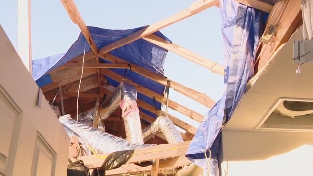
One week after a tornado took the majority of a home in Conroe, a line of storms and a cold front have this young homeowner worried.
One week after a tornado took the majority of a home in Conroe, a line of storms and a cold front have this young homeowner worried.

FOX 26 Houston weather: Jan. 6 forecast
A freeze warning is in effect until 9 a.m. and a cold weather advisory until 11 a.m. Today will be sunny, windy and cold with highs in the 40s and wind chills in the 20s and 30s.
A freeze warning is in effect until 9 a.m. and a cold weather advisory until 11 a.m. Today will be sunny, windy and cold with highs in the 40s and wind chills in the 20s and 30s.

Houston weather: Temperatures tumble across SE Texas
Temperatures are falling quickly across the Houston area after a cold front blew through on Sunday. FOX 26's John Dawson takes a look at just how cold we can expect things to get.
Temperatures are falling quickly across the Houston area after a cold front blew through on Sunday. FOX 26's John Dawson takes a look at just how cold we can expect things to get.


City of Houston, Star of Hope prepare for incoming cold weather
The City of Houston is preparing for the cold weather headed south as temperatures are forecasted to dip down into the 30s and officials want to make sure everyone has a plan in place.
The City of Houston is preparing for the cold weather headed south as temperatures are forecasted to dip down into the 30s and officials want to make sure everyone has a plan in place.

ERCOT issues Weather Watch as Texas expects to see freezing temperatures
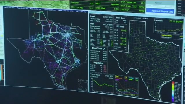
Texas power grid operator ERCOT has issued a Weather Watch for most of this week, due to the expected higher than usual demand.
Texas power grid operator ERCOT has issued a Weather Watch for most of this week, due to the expected higher than usual demand.

ERCOT issues Weather Watch from Jan. 6-10 due to cold weather forecasted
ERCOT has issued a Weather Watch from Jan. 6 to Jan. 10 due to anticipated cold weather across the Southeast Texas region.
ERCOT has issued a Weather Watch from Jan. 6 to Jan. 10 due to anticipated cold weather across the Southeast Texas region.

Houston weather: Winter weather for Southeast Texas, freeze warning for the area
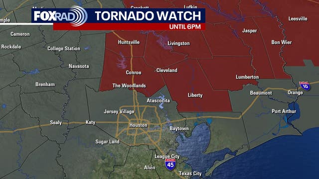
We are monitoring a winter weather storm that is going to be moving across 25 states over the next day or so. An area of low pressure and trailing front is bringing potential for some strong to severe storms to Southeast Texas today.
We are monitoring a winter weather storm that is going to be moving across 25 states over the next day or so. An area of low pressure and trailing front is bringing potential for some strong to severe storms to Southeast Texas today.

Houston evening weather forecast, Jan. 5
A strong cold front brought a line of storms across Southeast Texas Sunday and very cold air will move in behind the front Sunday night. There is a FREEZE WARNING in effect until 9am Monday across the entire viewing area and a COLD WEATHER ADVISORY in affect. With blustery winds feels like temperatures will be in the teens and 20s waking up Monday morning. Make sure you dress in layers bring your pets inside and limit your time outdoors during the early morning hours this upcoming week. Afternoon highs will be in the 40s and wake up temperatures near freezing. At this time the chance for a wintry precipitation in the Houston area is low, but the models continue to update, so make sure you stick with us on the free FOX LOCAL app for the latest.
A strong cold front brought a line of storms across Southeast Texas Sunday and very cold air will move in behind the front Sunday night. There is a FREEZE WARNING in effect until 9am Monday across the entire viewing area and a COLD WEATHER ADVISORY in affect. With blustery winds feels like temperatures will be in the teens and 20s waking up Monday morning. Make sure you dress in layers bring your pets inside and limit your time outdoors during the early morning hours this upcoming week. Afternoon highs will be in the 40s and wake up temperatures near freezing. At this time the chance for a wintry precipitation in the Houston area is low, but the models continue to update, so make sure you stick with us on the free FOX LOCAL app for the latest.

City of Houston preps for cold weather
The City of Houston is preparing for the weather to drop into the 30s for a few days this week. FOX 26's Jade Flury has how the city is preparing to aid Houstonians.
The City of Houston is preparing for the weather to drop into the 30s for a few days this week. FOX 26's Jade Flury has how the city is preparing to aid Houstonians.

Morning update on storms, cold air for Houston
FOX 26 Meteorologist Allison Gargaro has the latest update on the storms and cold air about to impact the Houston-area and Southeast Texas.
FOX 26 Meteorologist Allison Gargaro has the latest update on the storms and cold air about to impact the Houston-area and Southeast Texas.

Houston weather: Your Sunday morning forecast
We are monitoring a winter weather storm that is going to be moving across 25 states over the next day or so. An area of low pressure and trailing front, which is going to be bringing the potential for some strong to severe storms to us here in Southeast Texas today.
We are monitoring a winter weather storm that is going to be moving across 25 states over the next day or so. An area of low pressure and trailing front, which is going to be bringing the potential for some strong to severe storms to us here in Southeast Texas today.


Brazoria County residents recover from tornado, more severe weather looms
A deadly tornado struck Brazoria County last week and the Mejia family is still recovering from the devastation.
A deadly tornado struck Brazoria County last week and the Mejia family is still recovering from the devastation.

Houston evening weather forecast, Jan. 4
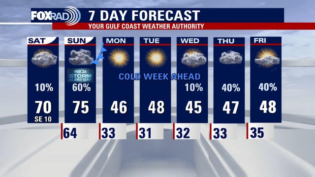
A major pattern change is on the way to Southeast Texas. Sunday wake up temperatures in the mid 60s with highs in the mid 70s. Then a strong cold front sweeps across Houston Sunday evening. Ahead of the front we could see showers and thunderstorms, some strong to severe. The main weather threats will be heavy, rain, damaging winds, and an isolated tornado. Make sure you have a way of receiving severe weather alerts. The coldest air of the season so far will linger around Southeast Texas all next week. Wake up temperatures will be in the upper 20s north of Houston and near freezing in Houston. With strong winds, wind chill values will be in the teens and 20s on Monday morning. Make sure that you dress in layers, bring your pets inside and cover any sensitive plants. Right now the chance for wintery precipitation is very low, but we are watching how things will develop towards the end of the week when a coastal low approaches.
A major pattern change is on the way to Southeast Texas. Sunday wake up temperatures in the mid 60s with highs in the mid 70s. Then a strong cold front sweeps across Houston Sunday evening. Ahead of the front we could see showers and thunderstorms, some strong to severe. The main weather threats will be heavy, rain, damaging winds, and an isolated tornado. Make sure you have a way of receiving severe weather alerts. The coldest air of the season so far will linger around Southeast Texas all next week. Wake up temperatures will be in the upper 20s north of Houston and near freezing in Houston. With strong winds, wind chill values will be in the teens and 20s on Monday morning. Make sure that you dress in layers, bring your pets inside and cover any sensitive plants. Right now the chance for wintery precipitation is very low, but we are watching how things will develop towards the end of the week when a coastal low approaches.


Kansas City Chiefs’ depart after ice storm strands them for hours on runway
The Kansas City Chiefs were stranded for hours Saturday at Kansas City International Airport as an ice storm shut down operations.
The Kansas City Chiefs were stranded for hours Saturday at Kansas City International Airport as an ice storm shut down operations.

Community still recovering from tornado outbreak
It has been a week since a deadly tornado struck Brazoria County and FOX 26's Jonathan Mejia spoke to a resident who was impacted. Residents in the area are now preparing for a new weather challenge.
It has been a week since a deadly tornado struck Brazoria County and FOX 26's Jonathan Mejia spoke to a resident who was impacted. Residents in the area are now preparing for a new weather challenge.

Houston weather: Strong cold front, showers forecasted Sunday evening
Houston residents should prepare for strong to severe storms on Sunday along with a drop in temperatures Monday morning.
Houston residents should prepare for strong to severe storms on Sunday along with a drop in temperatures Monday morning.

Weather update: Storms, plunging temps on Sunday
FOX 26 Meteorologist Allison Gargaro gives a more in-depth update on the severe weather rolling into the Houston-area on Sunday along with the expected plunge in temperatures from a cold front.
FOX 26 Meteorologist Allison Gargaro gives a more in-depth update on the severe weather rolling into the Houston-area on Sunday along with the expected plunge in temperatures from a cold front.

Houston morning weather forecast, Jan. 4
A major pattern change is on the way to Southeast Texas this weekend. You can expect highs today in Houston to remain in the low 70s with mostly cloudy skies, there is a chance for a light shower or two. We warm up even more on Sunday wake up temperatures in the mid 60s with highs in the mid 70s. A strong cold front will be sweeping across the region Sunday evening. Ahead of the front we could be seen showers and thunderstorms, some strong to severe. The main weather threats would be heavy, rain, damaging winds, and an isolated tornado. Make sure you have a way of receiving severe weather alerts. The coldest air of the season so far will be moving in next week. Wake up temperatures Monday will be in the upper 20s north of Houston and near freezing in Houston. With strong winds, wind chill values will be in the teens and 20s. Make sure that you dress in layers, bring your pets inside and cover any sensitive plants. Next week you can expect highs in the 40s and lows near freezing. Download the free FOX LOCAL app so you can stay up-to-date on the latest weather updates as an arctic blast will be making its way across southeast Texas.
A major pattern change is on the way to Southeast Texas this weekend. You can expect highs today in Houston to remain in the low 70s with mostly cloudy skies, there is a chance for a light shower or two. We warm up even more on Sunday wake up temperatures in the mid 60s with highs in the mid 70s. A strong cold front will be sweeping across the region Sunday evening. Ahead of the front we could be seen showers and thunderstorms, some strong to severe. The main weather threats would be heavy, rain, damaging winds, and an isolated tornado. Make sure you have a way of receiving severe weather alerts. The coldest air of the season so far will be moving in next week. Wake up temperatures Monday will be in the upper 20s north of Houston and near freezing in Houston. With strong winds, wind chill values will be in the teens and 20s. Make sure that you dress in layers, bring your pets inside and cover any sensitive plants. Next week you can expect highs in the 40s and lows near freezing. Download the free FOX LOCAL app so you can stay up-to-date on the latest weather updates as an arctic blast will be making its way across southeast Texas.

Preparing for the cold weather: Always remember the 4 P's
With the approaching cold weather, now is the time to prepare ahead of the bone chilling temperatures expected across the Houston area next week.
With the approaching cold weather, now is the time to prepare ahead of the bone chilling temperatures expected across the Houston area next week.


FOX 26 Houston Weather Forecast - Major weather pattern change coming!
As we prepare to go into another weekend, get ready for more unsettled weather including a potential round of severe storms and a huge drop in temperatures. Sunday is a FOX 26 Storm Alert Day with the threat of severe storms during the afternoon and freezing temperatures for some overnight. Other than a few areas of fog late tonight, weather should be quiet with temperatures dipping to the middle 50s in Houston. Saturday will be a warm and breezy day with temperatures climbing to the low 70s with only a 10% chance for rain. Weather takes a drastic turn on Sunday with a round of strong to severe storms likely between 11 AM - 6 PM. Isolated tornadoes and damaging wind gusts will be the main risks with the highest threat north of Interstate 10 and east of Interstate 45. Make sure to download our FOX 26 weather app so that you will have a way to get severe weather alerts in your area. As storms roll out much colder air rolls in as a powerful cold front sends temperatures dropping to near freezing by Monday morning. In fact, temperatures stay well below normal all next week with highs in the 40s and overnight lows in the low to middle 30s for Houston. 20s are likely some nights next week for areas north of Houston. So prepare for multiple nights of potential freezing temperatures next week and the slight possibility of a few snowflakes or sleet pellets. A coastal low is expected to develop near the lower Texas coast that will spread some moisture our way late Wednesday into Thursday. There will also be a chance for light precipitation late Thursday into Friday. Most of this will likely fall as rain, but there's still a very low chance that there could be a light wintry mix. Right now the timing does not appear favorable for any major snow or ice for the Houston area. Make sure you are prepared for the upcoming freeze by filling up your car with gas, protecting your sensitive plants and insulating your pipes. Remember you will need extra layers too as this will likely be the coldest air so far this season.
As we prepare to go into another weekend, get ready for more unsettled weather including a potential round of severe storms and a huge drop in temperatures. Sunday is a FOX 26 Storm Alert Day with the threat of severe storms during the afternoon and freezing temperatures for some overnight. Other than a few areas of fog late tonight, weather should be quiet with temperatures dipping to the middle 50s in Houston. Saturday will be a warm and breezy day with temperatures climbing to the low 70s with only a 10% chance for rain. Weather takes a drastic turn on Sunday with a round of strong to severe storms likely between 11 AM - 6 PM. Isolated tornadoes and damaging wind gusts will be the main risks with the highest threat north of Interstate 10 and east of Interstate 45. Make sure to download our FOX 26 weather app so that you will have a way to get severe weather alerts in your area. As storms roll out much colder air rolls in as a powerful cold front sends temperatures dropping to near freezing by Monday morning. In fact, temperatures stay well below normal all next week with highs in the 40s and overnight lows in the low to middle 30s for Houston. 20s are likely some nights next week for areas north of Houston. So prepare for multiple nights of potential freezing temperatures next week and the slight possibility of a few snowflakes or sleet pellets. A coastal low is expected to develop near the lower Texas coast that will spread some moisture our way late Wednesday into Thursday. There will also be a chance for light precipitation late Thursday into Friday. Most of this will likely fall as rain, but there's still a very low chance that there could be a light wintry mix. Right now the timing does not appear favorable for any major snow or ice for the Houston area. Make sure you are prepared for the upcoming freeze by filling up your car with gas, protecting your sensitive plants and insulating your pipes. Remember you will need extra layers too as this will likely be the coldest air so far this season.