


FOX 26 Houston Weather Forecast
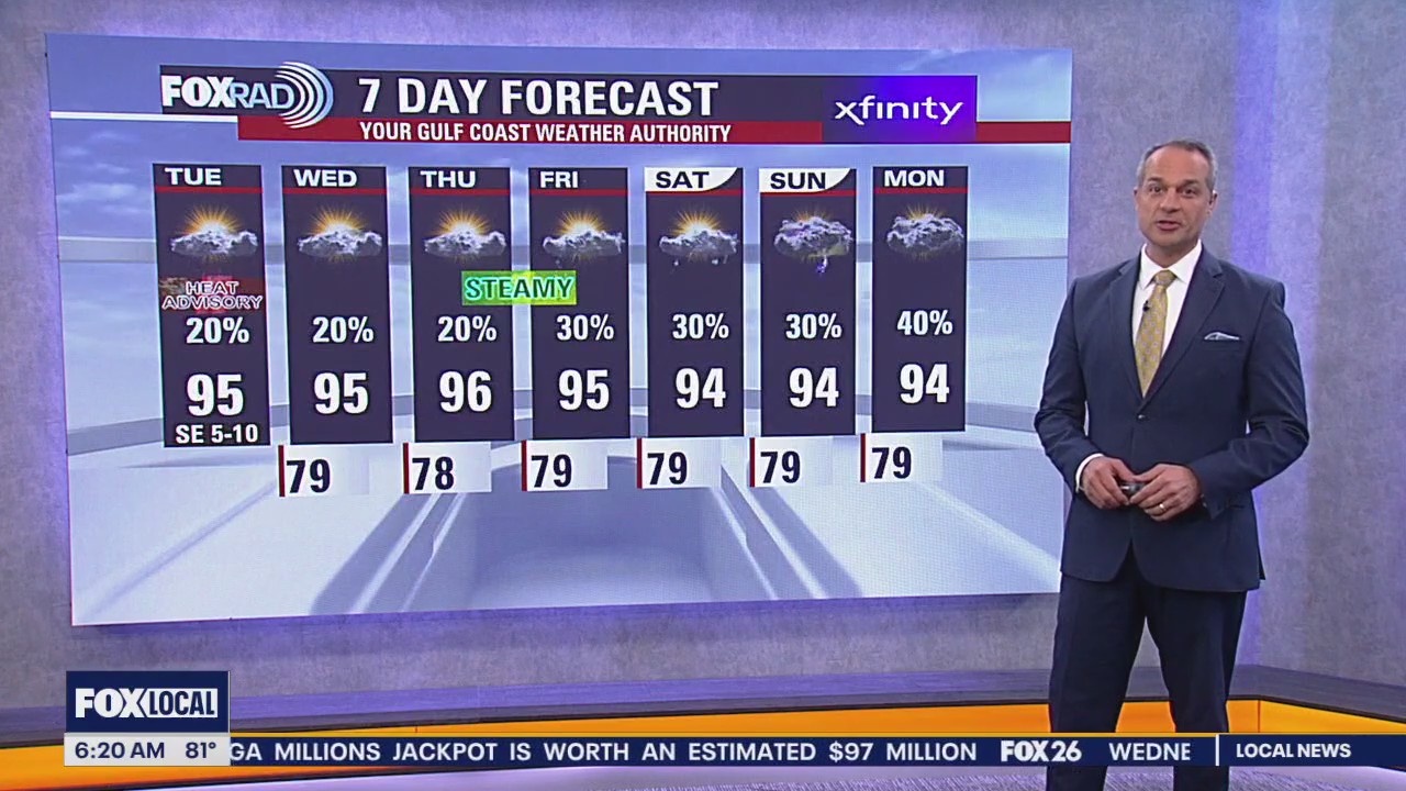
A hot, humid and hazy start to the week as a plume of Saharan Dust has arrived in SE Texas. A Heat Advisory is in effect today from noon until 7 p.m. with feels-like temperatures up to 110 degrees. Afternoon highs soar to the upper-90s. Isolated afternoon and evening storms are possible. Beryl is forecast to move across the Caribbean through the middle of the week and then nearing the Yucat?n Peninsula at the end of the week. Tropical Storm Chris formed in the southern Gulf of Mexico overnight. It has made landfall in Mexico and will weaken. Stay with FOX 26 for the latest updates on the free FOX Local app.
A hot, humid and hazy start to the week as a plume of Saharan Dust has arrived in SE Texas. A Heat Advisory is in effect today from noon until 7 p.m. with feels-like temperatures up to 110 degrees. Afternoon highs soar to the upper-90s. Isolated afternoon and evening storms are possible. Beryl is forecast to move across the Caribbean through the middle of the week and then nearing the Yucat?n Peninsula at the end of the week. Tropical Storm Chris formed in the southern Gulf of Mexico overnight. It has made landfall in Mexico and will weaken. Stay with FOX 26 for the latest updates on the free FOX Local app.


Extreme heat advisory in effect
Another Heat Advisory is in effect from noon until 7pm. Feels-like temperatures could peak as high as 111 degrees. Limit your time outside and stay hydrated. There is the chance for a few isolated storms this afternoon. A plume of Saharan dust arrives in Texas later today and into early next week. This will create some haze along the horizon and bring some gorgeous sunrises and sunsets.
Another Heat Advisory is in effect from noon until 7pm. Feels-like temperatures could peak as high as 111 degrees. Limit your time outside and stay hydrated. There is the chance for a few isolated storms this afternoon. A plume of Saharan dust arrives in Texas later today and into early next week. This will create some haze along the horizon and bring some gorgeous sunrises and sunsets.


FOX 26 Houston Weather Forecast
The Heat Advisories continue for Southeast Texas, now through at least Sunday evening. Use caution working or playing outdoors from Noon until 7 p.m. An isolated shower/storm is possible but not many will find their way across the Houston area. Sahara dust moves along the Texas coast Sunday through Tuesday bringing hazy skies along with some beautiful sunrises and sunsets.
The Heat Advisories continue for Southeast Texas, now through at least Sunday evening. Use caution working or playing outdoors from Noon until 7 p.m. An isolated shower/storm is possible but not many will find their way across the Houston area. Sahara dust moves along the Texas coast Sunday through Tuesday bringing hazy skies along with some beautiful sunrises and sunsets.


FOX 26 Houston Weather Forecast
It's still June but the deep summer heat is all across Southeast Texas. This weekend looks like a typical "August" weekend in Houston. Isolated storms are possible for Saturday but don't look for many to provide temporary cool-downs. Saharan dust moves in from the Gulf bringing hazy skies as temps continue to hover just below the triple digits. Most of the FOX26 area is under a Heat Advisory Saturday.
It's still June but the deep summer heat is all across Southeast Texas. This weekend looks like a typical "August" weekend in Houston. Isolated storms are possible for Saturday but don't look for many to provide temporary cool-downs. Saharan dust moves in from the Gulf bringing hazy skies as temps continue to hover just below the triple digits. Most of the FOX26 area is under a Heat Advisory Saturday.


Your Gulf Coast Weather Authority
Happy Friday, everyone. Yes, it's going to be another hot, humid day with a heat advisory in effect and afternoon temperatures reaching the mid to upper 90s. Expect some pop-up storms to temporarily cool things down - a similar outlook for Saturday. Beginning Sunday, a plume of Saharan dust could move into Texas bringing some hazy skies as temperatures rise in the mid and upper 90s. In the tropics, a strong tropical wave in the central Atlantic could become a tropical storm over the next few days. It is very far from here, so we have a long time to watch.
Happy Friday, everyone. Yes, it's going to be another hot, humid day with a heat advisory in effect and afternoon temperatures reaching the mid to upper 90s. Expect some pop-up storms to temporarily cool things down - a similar outlook for Saturday. Beginning Sunday, a plume of Saharan dust could move into Texas bringing some hazy skies as temperatures rise in the mid and upper 90s. In the tropics, a strong tropical wave in the central Atlantic could become a tropical storm over the next few days. It is very far from here, so we have a long time to watch.


FOX 26 Houston Weather Forecast
We are one week away from the 4th of July holiday and it looks like a typical hot and humid summer pattern for SE Texas. Look for high temperatures in the middle to upper 90s over the next week with rain chances around 10-30%. Two systems in the tropics are being monitored for development but should not bring us any major impacts through the 4th of July. Invest 94-L will move into the SW Gulf this weekend with only a low chance for development. Invest 95-L in the east-central Atlantic now has a high 80% chance of becoming a Tropical depression or Tropical Storm Beryl as it moves towards the Lesser Antilles. We still have several days to watch this one though. Keep track of the weather where you live and the tropics on FOX Local and through our FOX 26 weather app!
We are one week away from the 4th of July holiday and it looks like a typical hot and humid summer pattern for SE Texas. Look for high temperatures in the middle to upper 90s over the next week with rain chances around 10-30%. Two systems in the tropics are being monitored for development but should not bring us any major impacts through the 4th of July. Invest 94-L will move into the SW Gulf this weekend with only a low chance for development. Invest 95-L in the east-central Atlantic now has a high 80% chance of becoming a Tropical depression or Tropical Storm Beryl as it moves towards the Lesser Antilles. We still have several days to watch this one though. Keep track of the weather where you live and the tropics on FOX Local and through our FOX 26 weather app!

FOX 26 Houston Weather Forecast
We are one week away from the 4th of July holiday and it looks like a typical hot and humid summer pattern for Southeast Texas. Look for high temperatures in the middle to upper 90s over the next week with rain chances around 10-30%. Two systems in the tropics are being monitored for development but should not bring us any major impacts through the 4th of July. Invest 94-L will move into the SW Gulf this weekend with only a low chance for development. Invest 95-L in the east-central Atlantic now has a high 80% chance of becoming a Tropical depression or Tropical Storm Beryl as it moves towards the Lesser Antilles. We still have several days to watch this one though. Keep track of the weather where you live and the tropics on FOX Local and through our FOX 26 weather app!
We are one week away from the 4th of July holiday and it looks like a typical hot and humid summer pattern for Southeast Texas. Look for high temperatures in the middle to upper 90s over the next week with rain chances around 10-30%. Two systems in the tropics are being monitored for development but should not bring us any major impacts through the 4th of July. Invest 94-L will move into the SW Gulf this weekend with only a low chance for development. Invest 95-L in the east-central Atlantic now has a high 80% chance of becoming a Tropical depression or Tropical Storm Beryl as it moves towards the Lesser Antilles. We still have several days to watch this one though. Keep track of the weather where you live and the tropics on FOX Local and through our FOX 26 weather app!


Fox 26 Houston Weather Forecast
As you would expect, today is going to be another hot and humid one, but with afternoon storms expected again. A few could be briefly strong. Tomorrow will be hot again with isolated rain, then expect a steamy and hazy weekend. A combination of light smoke and a plume of Saharan dust should bring a brown tinge to the sky by early next week.
As you would expect, today is going to be another hot and humid one, but with afternoon storms expected again. A few could be briefly strong. Tomorrow will be hot again with isolated rain, then expect a steamy and hazy weekend. A combination of light smoke and a plume of Saharan dust should bring a brown tinge to the sky by early next week.

FOX 26 Houston Weather Forecast
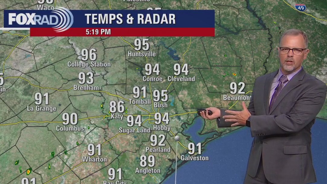
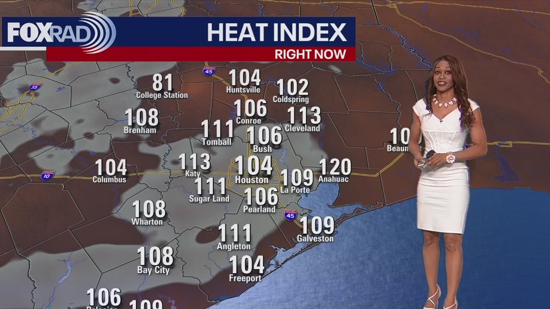
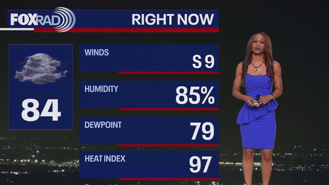
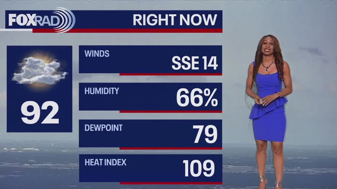
Dangerous heat index values above 108 are possible through this evening. Try not to do a lot of work outside during the afternoon, drink lots of water and try to find the shade if you must be outside. There's also a 30% chance for spotty storms this evening and Thursday evening. A few storms could be strong with gusty winds the main threat. We will remain stuck in this hot & humid pattern the next week with a few storms possible daily. Two systems in the tropics are being monitored. Invest 94-L in the central Caribbean has a low chance of development as it heads towards the SW Gulf this weekend. Invest 95-L in the east-central Atlantic now has a medium 40% chance for development over the next week as it moves closer to the Caribbean. Get the latest weather where you live by downloading our FOX 26 Weather App and by watching us on your smart TV through our FOX Local app!
Dangerous heat index values above 108 are possible through this evening. Try not to do a lot of work outside during the afternoon, drink lots of water and try to find the shade if you must be outside. There's also a 30% chance for spotty storms this evening and Thursday evening. A few storms could be strong with gusty winds the main threat. We will remain stuck in this hot & humid pattern the next week with a few storms possible daily. Two systems in the tropics are being monitored. Invest 94-L in the central Caribbean has a low chance of development as it heads towards the SW Gulf this weekend. Invest 95-L in the east-central Atlantic now has a medium 40% chance for development over the next week as it moves closer to the Caribbean. Get the latest weather where you live by downloading our FOX 26 Weather App and by watching us on your smart TV through our FOX Local app!

FOX 26 Houston Weather Forecast
HEAT ADVISORY remains in effect until 8 p.m. for all inland areas in Southeast Texas including Houston. Dangerous heat index values above 108 are possible through this evening. Try not to do a lot of work outside during the afternoon, drink lots of water, and try to find shade if you must be outside. There's also a 30% chance for spotty storms this evening and Thursday evening. A few storms could be strong with gusty winds the main threat. We will remain stuck in this hot & humid pattern the next week with a few storms possible daily. Two systems in the tropics are being monitored. Invest 94-L in the central Caribbean has a low chance of development as it heads towards the SW Gulf this weekend. Invest 95-L in the east-central Atlantic now has a medium 40% chance for development over the next week as it moves closer to the Caribbean. Get the latest weather where you live by downloading our FOX 26 Weather App and by watching us on your smart TV through our FOX Local app!
HEAT ADVISORY remains in effect until 8 p.m. for all inland areas in Southeast Texas including Houston. Dangerous heat index values above 108 are possible through this evening. Try not to do a lot of work outside during the afternoon, drink lots of water, and try to find shade if you must be outside. There's also a 30% chance for spotty storms this evening and Thursday evening. A few storms could be strong with gusty winds the main threat. We will remain stuck in this hot & humid pattern the next week with a few storms possible daily. Two systems in the tropics are being monitored. Invest 94-L in the central Caribbean has a low chance of development as it heads towards the SW Gulf this weekend. Invest 95-L in the east-central Atlantic now has a medium 40% chance for development over the next week as it moves closer to the Caribbean. Get the latest weather where you live by downloading our FOX 26 Weather App and by watching us on your smart TV through our FOX Local app!


FOX 26 Houston Weather Forecast
Heat Advisory has been extended until 8 pm Wednesday for much of Southeast Texas. It does not include the coastal areas. Heat index values near 110 are likely Wednesday afternoon. Even late at night, overnight temperatures will only fall to near 80. So there won't be much relief then either. We'll remain stuck in this pattern through the rest of the week with hot and steamy weather with isolated rain. A tropical wave in the eastern Caribbean has a low chance for development as it heads towards the southern Gulf by this weekend. It could enhance our rain chances early next week. But right now, impacts look minimal. However, that could change so keep checking back for weather where you live on our FOX 26 weather app and on FOX Local!
Heat Advisory has been extended until 8 pm Wednesday for much of Southeast Texas. It does not include the coastal areas. Heat index values near 110 are likely Wednesday afternoon. Even late at night, overnight temperatures will only fall to near 80. So there won't be much relief then either. We'll remain stuck in this pattern through the rest of the week with hot and steamy weather with isolated rain. A tropical wave in the eastern Caribbean has a low chance for development as it heads towards the southern Gulf by this weekend. It could enhance our rain chances early next week. But right now, impacts look minimal. However, that could change so keep checking back for weather where you live on our FOX 26 weather app and on FOX Local!


FOX 26 Houston Weather Forecast
Heat Advisory has been extended until 8 pm Wednesday for much of Southeast Texas. It does not include the coastal areas. Heat index values near 110 are likely Wednesday afternoon. Even late at night, overnight temperatures will only fall to near 80. So there won't be much relief then either. We'll remain stuck in this pattern through the rest of the week with hot and steamy weather with isolated rain. A tropical wave in the eastern Caribbean has a low chance for development as it heads towards the southern Gulf by this weekend. It could enhance our rain chances early next week. But right now, impacts look minimal. However, that could change so keep checking back for weather where you live on our FOX 26 Weather App and on FOX Local!
Heat Advisory has been extended until 8 pm Wednesday for much of Southeast Texas. It does not include the coastal areas. Heat index values near 110 are likely Wednesday afternoon. Even late at night, overnight temperatures will only fall to near 80. So there won't be much relief then either. We'll remain stuck in this pattern through the rest of the week with hot and steamy weather with isolated rain. A tropical wave in the eastern Caribbean has a low chance for development as it heads towards the southern Gulf by this weekend. It could enhance our rain chances early next week. But right now, impacts look minimal. However, that could change so keep checking back for weather where you live on our FOX 26 Weather App and on FOX Local!

Fox 26 Houston Weather Forecast
Get ready for a super hot and humid Tuesday with a heat index reaching at least 108. A heat advisory is in effect for all inland locations from noon through 8pm. Each day this weekend looks very similar with high heat and humidity along with isolated afternoon and early evening storms. A tropical wave could bring some additional rain early next week, but it's a bit early to know for sure.
Get ready for a super hot and humid Tuesday with a heat index reaching at least 108. A heat advisory is in effect for all inland locations from noon through 8pm. Each day this weekend looks very similar with high heat and humidity along with isolated afternoon and early evening storms. A tropical wave could bring some additional rain early next week, but it's a bit early to know for sure.

FOX 26 Houston Weather Forecast: The heat is back!
HEAT ADVISORY has been issued for most of SE Texas from Noon until 8pm Tuesday. It does not include coastal areas but includes the Houston metro area. Heat index values higher than 108 are likely. So drink lots of water, take frequent breaks and try not to work too hard in the heat during the hottest part of the day. Heat will remain intense but rain will be isolated the next few days. There's a low chance that a tropical wave currently near the Windward Islands could slowly develop by Friday or Saturday near the Yucatan Peninsula. This could enhance our rain chances slightly by this weekend so stay tuned. Otherwise, the heat will be the main issue. Also, swim with caution at area beaches with a risk for rip currents that continues. Get the latest weather where you live and an update on any threatening weather by downloading our FOX Local app for your big screen! You can now find it on Samsung TV!
HEAT ADVISORY has been issued for most of SE Texas from Noon until 8pm Tuesday. It does not include coastal areas but includes the Houston metro area. Heat index values higher than 108 are likely. So drink lots of water, take frequent breaks and try not to work too hard in the heat during the hottest part of the day. Heat will remain intense but rain will be isolated the next few days. There's a low chance that a tropical wave currently near the Windward Islands could slowly develop by Friday or Saturday near the Yucatan Peninsula. This could enhance our rain chances slightly by this weekend so stay tuned. Otherwise, the heat will be the main issue. Also, swim with caution at area beaches with a risk for rip currents that continues. Get the latest weather where you live and an update on any threatening weather by downloading our FOX Local app for your big screen! You can now find it on Samsung TV!


Fox 26 Houston Weather Forecast
Hot, humid, isolated storms...hot, humid, isolated storms...Hot, humid, isolated storms...That's what we're looking for all week. Over the weekend, a tropical disturbance moved into the same area of the the Mexican Gulf Coast that was just hit by T.S. Alberto last week. A tropical wave in the Caribbean could approach the Yucatan Peninsula by this weekend, so we'll watch that, but overall it's just going to be a steamy week here.
Hot, humid, isolated storms...hot, humid, isolated storms...Hot, humid, isolated storms...That's what we're looking for all week. Over the weekend, a tropical disturbance moved into the same area of the the Mexican Gulf Coast that was just hit by T.S. Alberto last week. A tropical wave in the Caribbean could approach the Yucatan Peninsula by this weekend, so we'll watch that, but overall it's just going to be a steamy week here.


Fox 26 Houston Weather Forecast
The first official week of summer is bringing the heat. Forecast highs today will soar to the mid-90s inland with feels-like temperatures up to 105 degrees. This trend continues into next week. There is the chance for a few isolated showers today, but overall coverage remains low. Stay safe in the heat this week- drink plenty of water and take breaks inside the a/c. Download the FOX Local app for the latest weather forecasts.
The first official week of summer is bringing the heat. Forecast highs today will soar to the mid-90s inland with feels-like temperatures up to 105 degrees. This trend continues into next week. There is the chance for a few isolated showers today, but overall coverage remains low. Stay safe in the heat this week- drink plenty of water and take breaks inside the a/c. Download the FOX Local app for the latest weather forecasts.


FOX 26 Houston Weather Forecast
The heat is on for the first weekend of summer 2024. Those around Houston will want to plan for hot and humid conditions with any outdoor activities. Isolated showers are possible Sunday afternoon but they would be brief. Careful along the coast. While the coastal flooding is finally ending, there remains high rip current risks at all the beaches.
The heat is on for the first weekend of summer 2024. Those around Houston will want to plan for hot and humid conditions with any outdoor activities. Isolated showers are possible Sunday afternoon but they would be brief. Careful along the coast. While the coastal flooding is finally ending, there remains high rip current risks at all the beaches.

FOX 26 Houston Weather Forecast
The first weekend of summer 2024 is upon us and you may be wanting to get outside and enjoy a concert, beach time, or head to an Astros game. There could still be some minor coastal flooding with slightly higher tide levels and coastal flood advisory continues for Galveston Island & the Bolivar Peninsula until 7 p.m. Saturday. There's also a high rip currents risk at area beaches. Rain will be very isolated Saturday with a few more showers possible Sunday afternoon. Some spotty showers are expected to stick around next week. But at this time we are not expecting widespread heavy rainfall. Get the latest weather where you live by downloading our FOX 26 Weather App and by watching our smart TV app FOX Local!
The first weekend of summer 2024 is upon us and you may be wanting to get outside and enjoy a concert, beach time, or head to an Astros game. There could still be some minor coastal flooding with slightly higher tide levels and coastal flood advisory continues for Galveston Island & the Bolivar Peninsula until 7 p.m. Saturday. There's also a high rip currents risk at area beaches. Rain will be very isolated Saturday with a few more showers possible Sunday afternoon. Some spotty showers are expected to stick around next week. But at this time we are not expecting widespread heavy rainfall. Get the latest weather where you live by downloading our FOX 26 Weather App and by watching our smart TV app FOX Local!


FOX 26 Houston Weather Forecast
The first weekend of summer 2024 is upon us and you may want to get outside and enjoy a concert, beach time, or head to an Astros game. There could still be some minor coastal flooding with slightly higher tide levels and coastal flood advisory continues for Galveston Island & the Bolivar Peninsula until 7 p.m. Saturday. There's also a high rip currents risk at area beaches. Rain will be very isolated Saturday with a few more showers possible Sunday afternoon. Some spotty showers are expected to stick around next week. But at this time we are not expecting widespread heavy rainfall. Get the latest weather where you live by downloading our FOX 26 Weather App and by watching our smart TV app FOX Local!
The first weekend of summer 2024 is upon us and you may want to get outside and enjoy a concert, beach time, or head to an Astros game. There could still be some minor coastal flooding with slightly higher tide levels and coastal flood advisory continues for Galveston Island & the Bolivar Peninsula until 7 p.m. Saturday. There's also a high rip currents risk at area beaches. Rain will be very isolated Saturday with a few more showers possible Sunday afternoon. Some spotty showers are expected to stick around next week. But at this time we are not expecting widespread heavy rainfall. Get the latest weather where you live by downloading our FOX 26 Weather App and by watching our smart TV app FOX Local!