


FOX 26 Houston Weather Forecast
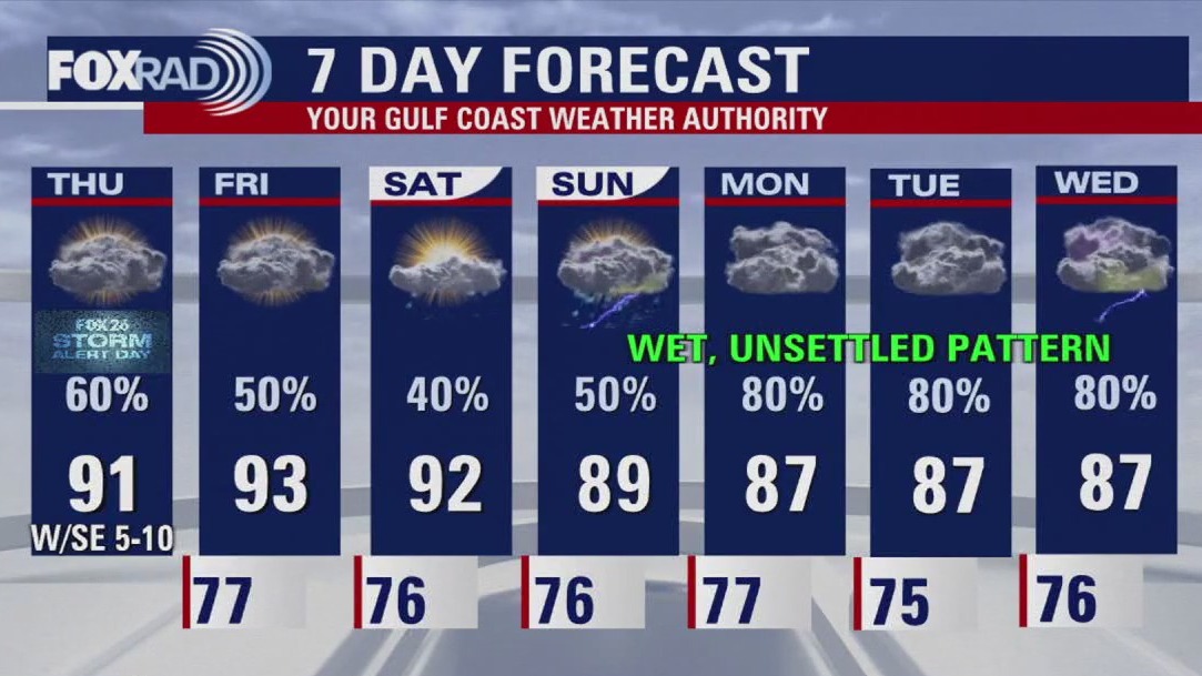
Big round of rain dropped into the Houston area this morning dumping anywhere from a trace to 4" of rain. Look for a few showers that might pop up this evening with more waves of rain on the way. Front will linger near the area this weekend keeping scattered showers and storms in the forecast. Unsettled weather pattern sticks around next week widespread rain likely. Models are showing an additional 3-5" of rain fire the Houston area through early next week. It will still be humid but temperatures will be a bit more comfortable with afternoon highs in the 80s Saturday through next week. Keep track of weather where you live and get a detailed tropics update by downloading our FOX 26 Weather App and our smart tv app FOX Local!
Big round of rain dropped into the Houston area this morning dumping anywhere from a trace to 4" of rain. Look for a few showers that might pop up this evening with more waves of rain on the way. Front will linger near the area this weekend keeping scattered showers and storms in the forecast. Unsettled weather pattern sticks around next week widespread rain likely. Models are showing an additional 3-5" of rain fire the Houston area through early next week. It will still be humid but temperatures will be a bit more comfortable with afternoon highs in the 80s Saturday through next week. Keep track of weather where you live and get a detailed tropics update by downloading our FOX 26 Weather App and our smart tv app FOX Local!

Houston weather: FOX 26 Storm Alert Day
Happy Friday Eve, everyone. As if we haven't had enough rain or enough of a mosquito invasion, there is a lot more on the way. Watch for stormy weather this morning, especially north of Houston, then more storms possible late this afternoon. Hit and miss showers and storms should stick around for tomorrow and Saturday, but rain looks more likely beginning Sunday and especially through next week. In fact, next week looks pretty ugly. More details as we get closer. Good times.
Happy Friday Eve, everyone. As if we haven't had enough rain or enough of a mosquito invasion, there is a lot more on the way. Watch for stormy weather this morning, especially north of Houston, then more storms possible late this afternoon. Hit and miss showers and storms should stick around for tomorrow and Saturday, but rain looks more likely beginning Sunday and especially through next week. In fact, next week looks pretty ugly. More details as we get closer. Good times.


FOX 26 Houston Weather Forecast: Off and on rain possible
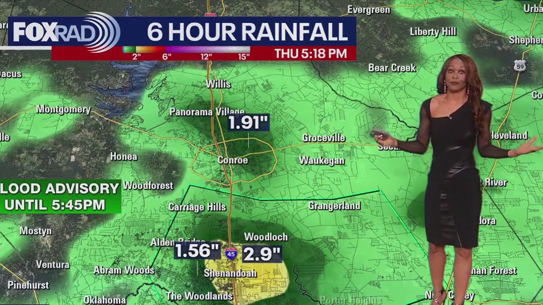
As expected, spotty heavy downpours have once again dumped 1 to nearly 3 inches of rain over parts of the area. Flood threat will increase tomorrow and Friday as a front drops in from the north triggering more showers and storms. In fact, rain chances remain fairly high for the next several days. So plan on possible delays to outdoor plans. At least temperatures will be a bit more comfortable with more clouds & rain around. Tropical action is not expected to impact our area for at least the next week with lots of Saharan dust across the Atlantic basin.
As expected, spotty heavy downpours have once again dumped 1 to nearly 3 inches of rain over parts of the area. Flood threat will increase tomorrow and Friday as a front drops in from the north triggering more showers and storms. In fact, rain chances remain fairly high for the next several days. So plan on possible delays to outdoor plans. At least temperatures will be a bit more comfortable with more clouds & rain around. Tropical action is not expected to impact our area for at least the next week with lots of Saharan dust across the Atlantic basin.

FOX 26 Houston Weather Forecast
As expected, spotty heavy downpours have once again dumped one to nearly three inches of rain over parts of the area. Flood threat will increase tomorrow and Friday as a front drops in from the north triggering more showers and storms. In fact, rain chances remain fairly high for the next several days. So plan on possible delays to outdoor plans. At least temperatures will be a bit more comfortable with more clouds & rain around. Tropical action is not expected to impact our area for at least the next week with lots of Saharan dust across the Atlantic basin.
As expected, spotty heavy downpours have once again dumped one to nearly three inches of rain over parts of the area. Flood threat will increase tomorrow and Friday as a front drops in from the north triggering more showers and storms. In fact, rain chances remain fairly high for the next several days. So plan on possible delays to outdoor plans. At least temperatures will be a bit more comfortable with more clouds & rain around. Tropical action is not expected to impact our area for at least the next week with lots of Saharan dust across the Atlantic basin.


FOX 26 News at Noon
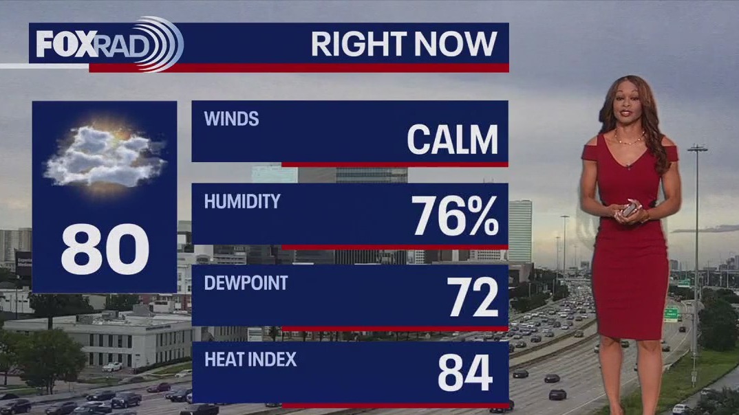
Houston will be hot and humid today with feels-like temperatures around 105 degrees. Drink plenty of fluids and take breaks inside the a/c. A bit of a drop in temperatures is expected this weekend as rain chances rise. Expect scattered showers and isolated storms each day through at least the start of next week. A friendly reminder, when thunder roars, head indoors. Download the free FOX Local TV app to stay up to day on local weather and the tropics.
Houston will be hot and humid today with feels-like temperatures around 105 degrees. Drink plenty of fluids and take breaks inside the a/c. A bit of a drop in temperatures is expected this weekend as rain chances rise. Expect scattered showers and isolated storms each day through at least the start of next week. A friendly reminder, when thunder roars, head indoors. Download the free FOX Local TV app to stay up to day on local weather and the tropics.


FOX 26 Houston Weather Forecast
Houston will be hot and humid today with feels-like temperatures around 105 degrees. Drink plenty of fluids and take breaks inside the a/c. A bit of a drop in temperatures is expected this weekend as rain chances rise. Expect scattered showers and isolated storms each day through at least the start of next week. A friendly reminder, when thunder roars, head indoors. Download the free FOX Local TV app to stay up to day on local weather and the tropics.
Houston will be hot and humid today with feels-like temperatures around 105 degrees. Drink plenty of fluids and take breaks inside the a/c. A bit of a drop in temperatures is expected this weekend as rain chances rise. Expect scattered showers and isolated storms each day through at least the start of next week. A friendly reminder, when thunder roars, head indoors. Download the free FOX Local TV app to stay up to day on local weather and the tropics.


FOX 26 Houston Weather Forecast: More rain on the way!
We are close to heat advisory criteria today and again tomorrow afternoon with heat index values near 106. Drink plenty of water, take it easy in the heat and try to find a cooling center if you are still without power. Look for a pattern change the rest of the week. Temperatures will go down a bit but clouds and rain increase, especially by Thursday and Friday. That could lead to a few flooded streets and delays for outdoor plans. Check out our smart TV app, Fox Local, to get in-depth updates on weather where you live and a detailed tropics update!
We are close to heat advisory criteria today and again tomorrow afternoon with heat index values near 106. Drink plenty of water, take it easy in the heat and try to find a cooling center if you are still without power. Look for a pattern change the rest of the week. Temperatures will go down a bit but clouds and rain increase, especially by Thursday and Friday. That could lead to a few flooded streets and delays for outdoor plans. Check out our smart TV app, Fox Local, to get in-depth updates on weather where you live and a detailed tropics update!


FOX 26 Houston Weather Forecast
We are close to heat advisory criteria today and again tomorrow afternoon with heat index values near 106. Drink plenty of water, take it easy in the heat and try to find a cooling center if you are still without power. Look for a pattern change for the rest of the week. Temperatures will go down a bit but clouds and rain increase, especially by Thursday and Friday. That could lead to a few flooded streets and delays for outdoor plans. Check out our smart TV app Fox Local to get in-depth updates on the weather where you live and a detailed tropics update!
We are close to heat advisory criteria today and again tomorrow afternoon with heat index values near 106. Drink plenty of water, take it easy in the heat and try to find a cooling center if you are still without power. Look for a pattern change for the rest of the week. Temperatures will go down a bit but clouds and rain increase, especially by Thursday and Friday. That could lead to a few flooded streets and delays for outdoor plans. Check out our smart TV app Fox Local to get in-depth updates on the weather where you live and a detailed tropics update!


Indiana resident killed after tree falls on home amid severe weather identified
A person was killed when a tree fell on their house in Cedar Lake, Indiana, as powerful storms barreled through the Chicagoland area on Monday night.
A person was killed when a tree fell on their house in Cedar Lake, Indiana, as powerful storms barreled through the Chicagoland area on Monday night.


Fox 26 Houston Weather Forecast
It?s another hot and humid day across SE Texas. Highs will reach the mid-90s with feels-like temperatures soaring to 105 degrees+. Make sure you have plans to stay inside the a/c and drink plenty of water. There is the chance for a few isolated showers today, but rain chances rise later this week and into the weekend. With higher rain chances comes a bit of a dip in temperatures down to the upper-80s this weekend. Download the free FOX Local tv app to stay up-to-date on weather where you live.
It?s another hot and humid day across SE Texas. Highs will reach the mid-90s with feels-like temperatures soaring to 105 degrees+. Make sure you have plans to stay inside the a/c and drink plenty of water. There is the chance for a few isolated showers today, but rain chances rise later this week and into the weekend. With higher rain chances comes a bit of a dip in temperatures down to the upper-80s this weekend. Download the free FOX Local tv app to stay up-to-date on weather where you live.


Fox 26 Houston Weather Forecast
Today and tomorrow will bring some of the warmest and more humid weather since Hurricane Beryl with highs in the mid 90s and a heat index near 105. Other than one or two isolated storms, sunshine will dominate in the short term. Beginning Wednesday, rain chances will rise and that trend will continue time through the weekend. Fortunately, the tropics remain quiet for now and no development is expected this week.
Today and tomorrow will bring some of the warmest and more humid weather since Hurricane Beryl with highs in the mid 90s and a heat index near 105. Other than one or two isolated storms, sunshine will dominate in the short term. Beginning Wednesday, rain chances will rise and that trend will continue time through the weekend. Fortunately, the tropics remain quiet for now and no development is expected this week.


FOX 26 Houston Weather Forecast
Today and tomorrow will bring some of the warmest and more humid weather since Hurricane Beryl with highs in the mid 90s and a heat index near 105. Other than one or two isolated storms, sunshine will dominate in the short term. Beginning Wednesday, rain chances will rise and that trend will continue time through the weekend. Fortunately, the tropics remain quiet for now and no development is expected this week.
Today and tomorrow will bring some of the warmest and more humid weather since Hurricane Beryl with highs in the mid 90s and a heat index near 105. Other than one or two isolated storms, sunshine will dominate in the short term. Beginning Wednesday, rain chances will rise and that trend will continue time through the weekend. Fortunately, the tropics remain quiet for now and no development is expected this week.


Fox 26 Houston Weather Forecast
Sunday saw a few downpours across the Houston area but overall less than yesterday. That trend of less rain will continue to start the week. With less rain, the temperature forecast goes back up and the heat index returns to around 105 for Monday and Tuesday. Rain chances increase again starting on Wednesday and temps will drop back into the lower 90s. Be safe in the heat this week!
Sunday saw a few downpours across the Houston area but overall less than yesterday. That trend of less rain will continue to start the week. With less rain, the temperature forecast goes back up and the heat index returns to around 105 for Monday and Tuesday. Rain chances increase again starting on Wednesday and temps will drop back into the lower 90s. Be safe in the heat this week!


Fox 26 Houston Weather Forecast
Good Sunday morning, everyone. We're looking for a trend toward less rain and hotter days beginning today, but much more Monday and Tuesday. Let's hope everyone power by then because the heat index will get close to 105 again. Watch for a few storms this afternoon with an otherwise warm and humid day. That won't last long as higher rain chances return from mid-week through the weekend. Gladly, the tropics are nice and quiet for now.
Good Sunday morning, everyone. We're looking for a trend toward less rain and hotter days beginning today, but much more Monday and Tuesday. Let's hope everyone power by then because the heat index will get close to 105 again. Watch for a few storms this afternoon with an otherwise warm and humid day. That won't last long as higher rain chances return from mid-week through the weekend. Gladly, the tropics are nice and quiet for now.


FOX 26 Houston Weather Forecast
Look for the weekend to end a lot like it started with scattered afternoon downpours and spotty sunshine. The work week starts off warmer and with less rain than the weekend. Expect the heat index to stay around 105 for the next several days. The end of the week should bring higher rain chances back into the forecast.
Look for the weekend to end a lot like it started with scattered afternoon downpours and spotty sunshine. The work week starts off warmer and with less rain than the weekend. Expect the heat index to stay around 105 for the next several days. The end of the week should bring higher rain chances back into the forecast.


FOX 26 Houston Weather Forecast
Hurricane Beryl blasted across the Houston area early Monday bringing 70-100 mph winds and over a foot of rain to Houston. Five days later, several hundred thousand Houstonians are still without power and with no A/C. Scattered showers and storms have brought some heat relief the last few days & we'll have another round Saturday. But lightning might slow down crews restoring power from the storm. Rain chances will get lower early next week as temperatures increase so be careful in the heat!
Hurricane Beryl blasted across the Houston area early Monday bringing 70-100 mph winds and over a foot of rain to Houston. Five days later, several hundred thousand Houstonians are still without power and with no A/C. Scattered showers and storms have brought some heat relief the last few days & we'll have another round Saturday. But lightning might slow down crews restoring power from the storm. Rain chances will get lower early next week as temperatures increase so be careful in the heat!


FOX 26 Houston Weather Forecast
Scattered heavy downpours brought electricity repairs to a halt briefly yesterday as some locations received more than 2 inches of rain accompanied by vivid, frequent lightning. We could see a repeat performance today and Saturday with some scattered thunderstorms expected, and a few of them could be heavy. A heat advisory is in effect again today, but most locations will have high temperatures of 90? or even slightly lower. Beyond Saturday, our forecast does look a bit warmer with high temperatures back in the low to middle 90s for Sunday through early next week. In the tropics, despite some rumors online to the contrary, we don?t see any systems forming over the next several days and everything looks relatively quiet for a while.
Scattered heavy downpours brought electricity repairs to a halt briefly yesterday as some locations received more than 2 inches of rain accompanied by vivid, frequent lightning. We could see a repeat performance today and Saturday with some scattered thunderstorms expected, and a few of them could be heavy. A heat advisory is in effect again today, but most locations will have high temperatures of 90? or even slightly lower. Beyond Saturday, our forecast does look a bit warmer with high temperatures back in the low to middle 90s for Sunday through early next week. In the tropics, despite some rumors online to the contrary, we don?t see any systems forming over the next several days and everything looks relatively quiet for a while.


FOX 26 Houston Weather Forecast
Flooding is once again a concern across the Houston area with rain and storms breaking out today. Rain led to some flooding across Houston and The Woodlands. Rain will wind down by sunset with more scattered storms the next few afternoons. That will mean some relief from the heat. But storms could delay crews trying to restore power to nearly one million Houstonians. Rain chances get a bit lower next week but the heat will increase again. One disturbance off the Florida east coast has a 10% chance of tropical development the next few days. But no tropical activity is expected in the Gulf of Mexico through the weekend.
Flooding is once again a concern across the Houston area with rain and storms breaking out today. Rain led to some flooding across Houston and The Woodlands. Rain will wind down by sunset with more scattered storms the next few afternoons. That will mean some relief from the heat. But storms could delay crews trying to restore power to nearly one million Houstonians. Rain chances get a bit lower next week but the heat will increase again. One disturbance off the Florida east coast has a 10% chance of tropical development the next few days. But no tropical activity is expected in the Gulf of Mexico through the weekend.


FOX 26 Houston Weather Forecast
Please take care of yourself and be careful because today we have both a heat advisory and expect scattered thunderstorms. Heat is the continuing hazard with so many without power and, with thousands working outdoors to cleanup after Beryl, lightning is a concern. ?When thunder roars, go indoors?. In the extended outlook, we?ll have a good chance for scattered storms tomorrow and Saturday, but beyond that we are looking very hot and humid.
Please take care of yourself and be careful because today we have both a heat advisory and expect scattered thunderstorms. Heat is the continuing hazard with so many without power and, with thousands working outdoors to cleanup after Beryl, lightning is a concern. ?When thunder roars, go indoors?. In the extended outlook, we?ll have a good chance for scattered storms tomorrow and Saturday, but beyond that we are looking very hot and humid.