

Thursday Night Weather Update
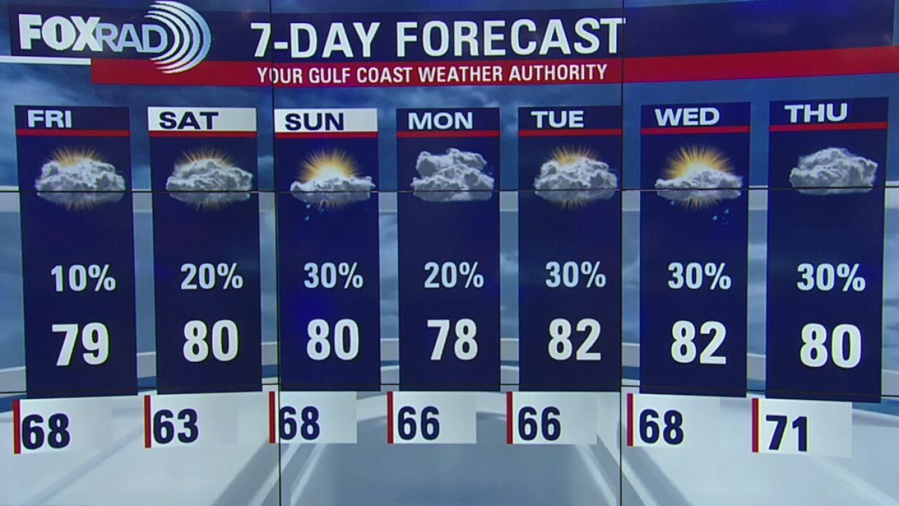
The forecast is holding very steady with warm temps, only a slight chance for a brief shower, and some patchy fog during the early morning hours. The weekend and even early next week will have the same weather pattern.
The forecast is holding very steady with warm temps, only a slight chance for a brief shower, and some patchy fog during the early morning hours. The weekend and even early next week will have the same weather pattern.

Thursday Evening Weather Update
The forecast is holding very steady with warm temps, only a slight chance for a brief shower, and some patchy fog during the early morning hours.
The forecast is holding very steady with warm temps, only a slight chance for a brief shower, and some patchy fog during the early morning hours.

Thursday morning weather forecast
Portions of the area starting the morning off with dense fog, especially closer to the coast. A dense fog advisory remains in effect until 10AM for those coastal counties. This afternoon, we should see peeks of sun. It'll be another mild afternoon with highs reaching the low 80s inland and mid 70s closer to the coast. The afternoon rain threat is very low today, with better chances as we head into the weekend.
Portions of the area starting the morning off with dense fog, especially closer to the coast. A dense fog advisory remains in effect until 10AM for those coastal counties. This afternoon, we should see peeks of sun. It'll be another mild afternoon with highs reaching the low 80s inland and mid 70s closer to the coast. The afternoon rain threat is very low today, with better chances as we head into the weekend.

Wednesday Night Weather Update
The current weather pattern remains in place for the rest of the week and into the weekend. F og will be present early each day as well.
The current weather pattern remains in place for the rest of the week and into the weekend. F og will be present early each day as well.

Wednesday Evening Weather Update
The current weather pattern remains in place for the rest of the week and into the weekend. Highs in the upper 70s to low 80s, lows in the 60s, and only a slight chance for a brief shower or two.
The current weather pattern remains in place for the rest of the week and into the weekend. Highs in the upper 70s to low 80s, lows in the 60s, and only a slight chance for a brief shower or two.

Wednesday morning weather forecast
We're dealing with patches of dense fog once again this morning with a dense fog advisory for counties to the west and south of Houston until 10 a.m. Fog will be slow to clear this morning, but once it does we should see plenty of sun with temperatures warming into the low 80s. While a stray shower can't be ruled out, it looks like the next couple of days will be dry. Rain chances return to about 20% by Friday and extend through the weekend.
We're dealing with patches of dense fog once again this morning with a dense fog advisory for counties to the west and south of Houston until 10 a.m. Fog will be slow to clear this morning, but once it does we should see plenty of sun with temperatures warming into the low 80s. While a stray shower can't be ruled out, it looks like the next couple of days will be dry. Rain chances return to about 20% by Friday and extend through the weekend.

Tuesday Night Weather Update
Expect hit and miss showers for Friday and the weekend as temperatures remain mild.
Expect hit and miss showers for Friday and the weekend as temperatures remain mild.

Tuesday Afternoon Weather Update
Wednesday and Thursday bring lower chances for rain and highs in the low 80s.
Wednesday and Thursday bring lower chances for rain and highs in the low 80s.
Tuesday afternoon weather forecast
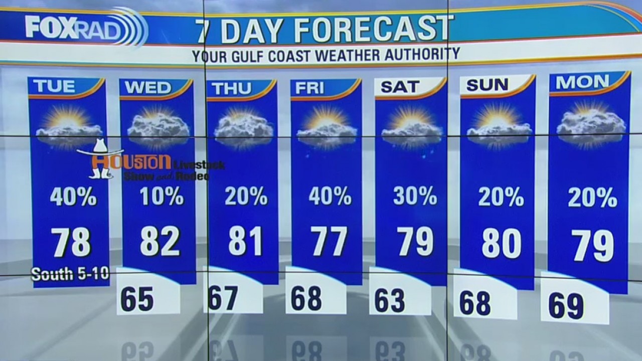
Overall, our pattern continues to look mild and spring-like for the rest of the week. Watch for scattered showers today with an isolated storm possible and otherwise warmer temps. Wednesday and Thursday bring lower chances for rain and highs in the low 80s. Expect hit and miss showers for Friday and the weekend as temperatures remain mild.
Overall, our pattern continues to look mild and spring-like for the rest of the week. Watch for scattered showers today with an isolated storm possible and otherwise warmer temps. Wednesday and Thursday bring lower chances for rain and highs in the low 80s. Expect hit and miss showers for Friday and the weekend as temperatures remain mild.

Tuesday morning weather forecast
Overall, our pattern continues to look mild and spring-like for the rest of the week. Watch for scattered showers today with an isolated storm possible and otherwise warmer temps. Wednesday and Thursday bring lower chances for rain and highs in the low 80s. Expect hit and miss showers for Friday and the weekend as temperatures remain mild.
Overall, our pattern continues to look mild and spring-like for the rest of the week. Watch for scattered showers today with an isolated storm possible and otherwise warmer temps. Wednesday and Thursday bring lower chances for rain and highs in the low 80s. Expect hit and miss showers for Friday and the weekend as temperatures remain mild.

Monday Night Weather Update
By the end of the week, models are mixed on whether an approaching cold front will stall to our north or briefly push through.
By the end of the week, models are mixed on whether an approaching cold front will stall to our north or briefly push through.
Monday Evening Weather Update
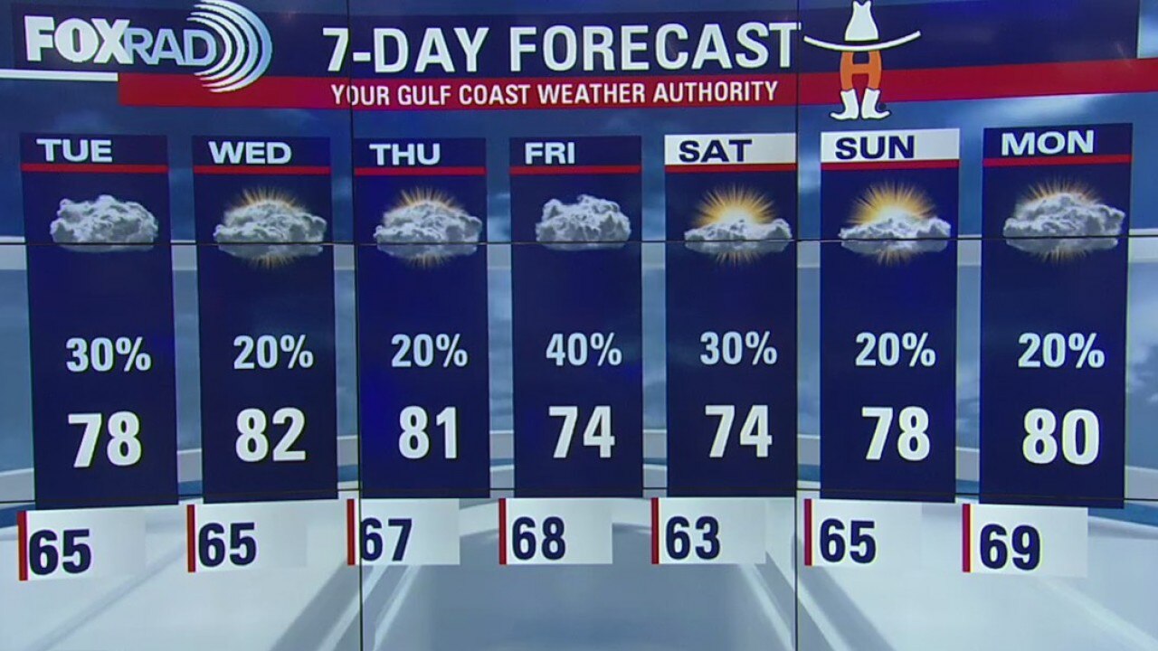
Wednesday and Thursday are looking slightly warmer with a lower chance for showers.
Wednesday and Thursday are looking slightly warmer with a lower chance for showers.
Monday morning weather forecast
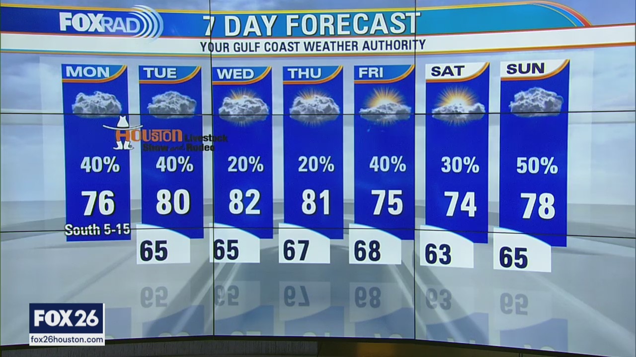
Mostly cloudy, breezy and mild with scattered late day and evening showers. Highs in the mid 70s.
Mostly cloudy, breezy and mild with scattered late day and evening showers. Highs in the mid 70s.
Sunday Night Weather Update
We'll be seeing some showers throughout spring break, but nothing too serious.
We'll be seeing some showers throughout spring break, but nothing too serious.

Houston area weather forecast 3/8
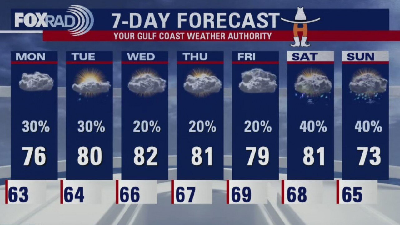
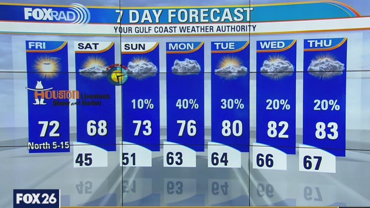
While it's a cool start to our Sunday, it's not as chilly as Saturday. Temperatures will warm into the low 70s this afternoon with a mix of sun and clouds. Rain chances return as early as Monday, but mild temps are here to stay for the week.
While it's a cool start to our Sunday, it's not as chilly as Saturday. Temperatures will warm into the low 70s this afternoon with a mix of sun and clouds. Rain chances return as early as Monday, but mild temps are here to stay for the week.
Saturday Night Weather Update
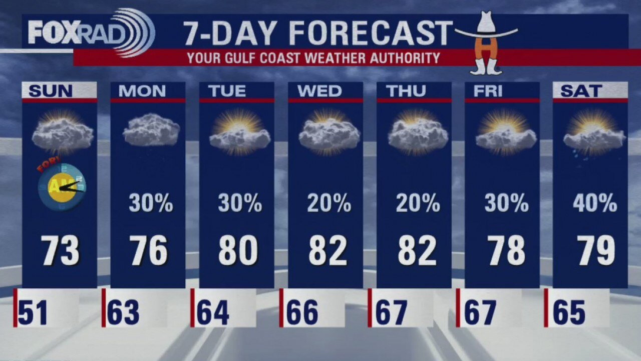
The coming week will have a daily chance for rain, but nothing looks overly organized. The rain chances drop to 20% by the middle of the week.
The coming week will have a daily chance for rain, but nothing looks overly organized. The rain chances drop to 20% by the middle of the week.
Houston area weather forecast 3/7
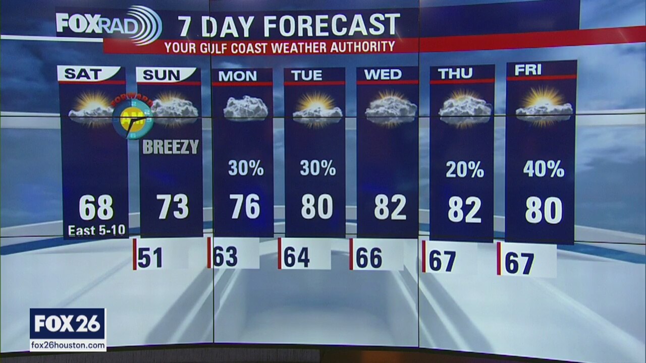
After a chilly start to our Saturday, we'll gradually warm into the upper 60s this afternoon. Clouds will be on the increase throughout the rain, but we don't expect to see any rain. Warmer on Sunday with rain chances increasing as early as Monday.
After a chilly start to our Saturday, we'll gradually warm into the upper 60s this afternoon. Clouds will be on the increase throughout the rain, but we don't expect to see any rain. Warmer on Sunday with rain chances increasing as early as Monday.

Friday Night Weather Update
Next week, a more humid south breeze returns which will bring a daily chance for scattered showers along with warmer temperatures.
Next week, a more humid south breeze returns which will bring a daily chance for scattered showers along with warmer temperatures.
Friday Evening Weather Update
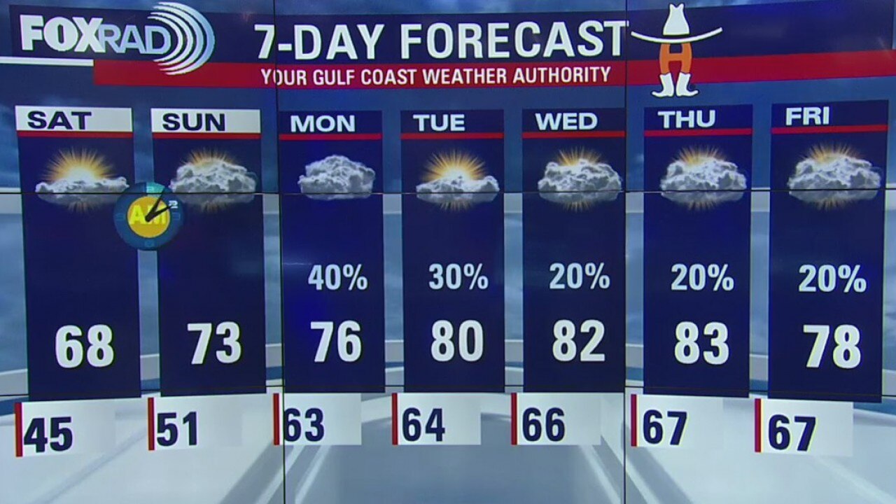
The weekend will be a little cool in the mornings, but the afternoons look nice.
The weekend will be a little cool in the mornings, but the afternoons look nice.
Friday morning weather forecast
Clear and chilly this morning, the sunny and dry with highs in the low 70s.
Clear and chilly this morning, the sunny and dry with highs in the low 70s.