

Houston area weather forecast 4-12
The threat for severe weather will remain to the north of Houston through this morning and then conditions will clear out areawide. This afternoon, it will be mild and windy following the passage of a cold front. Next week is shaping up to be much cooler with highs around 70 degrees and lows in the low 50s.
The threat for severe weather will remain to the north of Houston through this morning and then conditions will clear out areawide. This afternoon, it will be mild and windy following the passage of a cold front. Next week is shaping up to be much cooler with highs around 70 degrees and lows in the low 50s.

Saturday Evening Weather Forecast
Your Gulf Coast Weather Authority Meteorologist John Dawson gives you a look at where storms will hit this weekend.
Your Gulf Coast Weather Authority Meteorologist John Dawson gives you a look at where storms will hit this weekend.

Houston area weather forecast 4-11
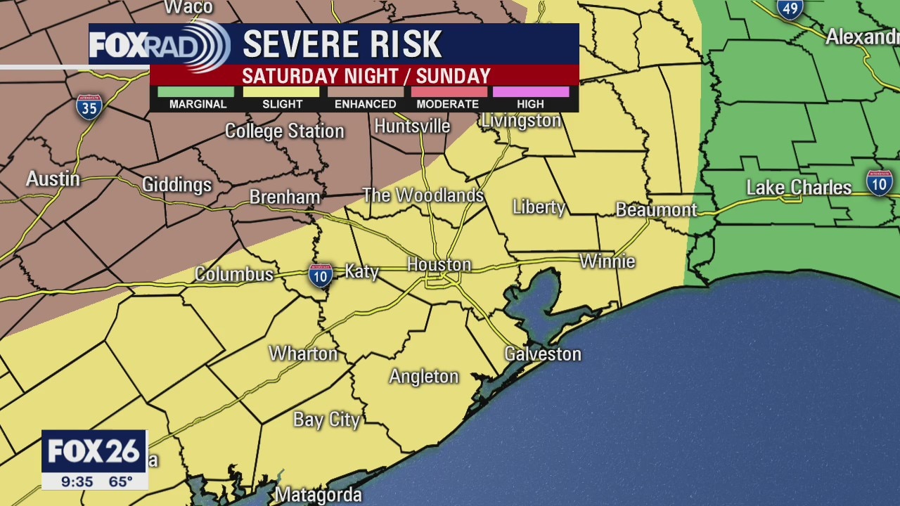
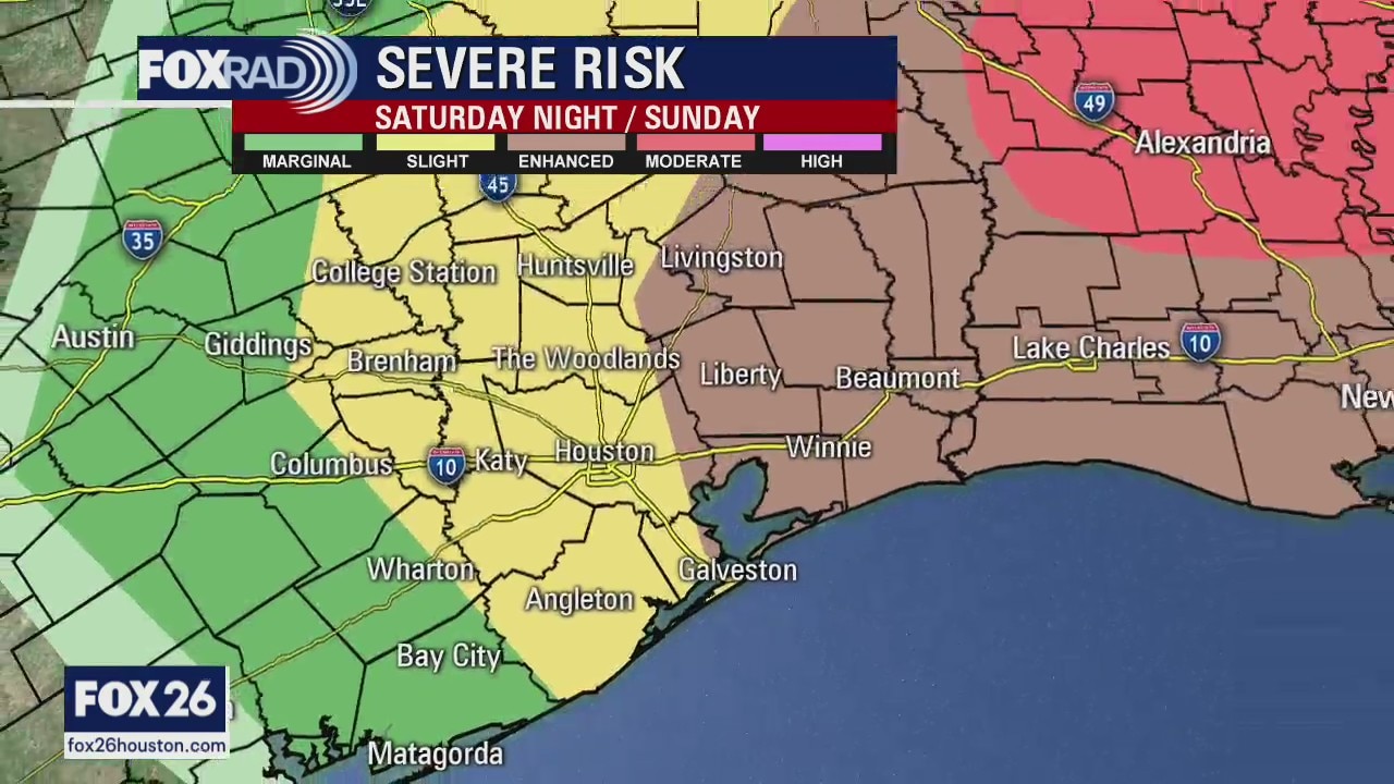
Several areas starting off cooler for Saturday, but things will gradually warm into the afternoon. A stray shower or storm can't be ruled out this evening, but the best chance for storms will come area-wide early Sunday morning. A few storms could be strong to severe. Cooler weather will filter in as we head toward Monday, with highs only reaching the upper 60s!
Several areas starting off cooler for Saturday, but things will gradually warm into the afternoon. A stray shower or storm can't be ruled out this evening, but the best chance for storms will come area-wide early Sunday morning. A few storms could be strong to severe. Cooler weather will filter in as we head toward Monday, with highs only reaching the upper 60s!
Weekend Weather Forecast
Your Gulf Coast Weather Authority Meteorologist John Dawson gives you a look ahead at storms rolling through the Houston metro area this weekend.
Your Gulf Coast Weather Authority Meteorologist John Dawson gives you a look ahead at storms rolling through the Houston metro area this weekend.
Friday Evening Weather Forecast
Your Gulf Coast Weather Authority Meteorologist John Dawson gives you a look ahead at showers expected to move through the Houston metro area this weekend.
Your Gulf Coast Weather Authority Meteorologist John Dawson gives you a look ahead at showers expected to move through the Houston metro area this weekend.

Friday morning weather forecast
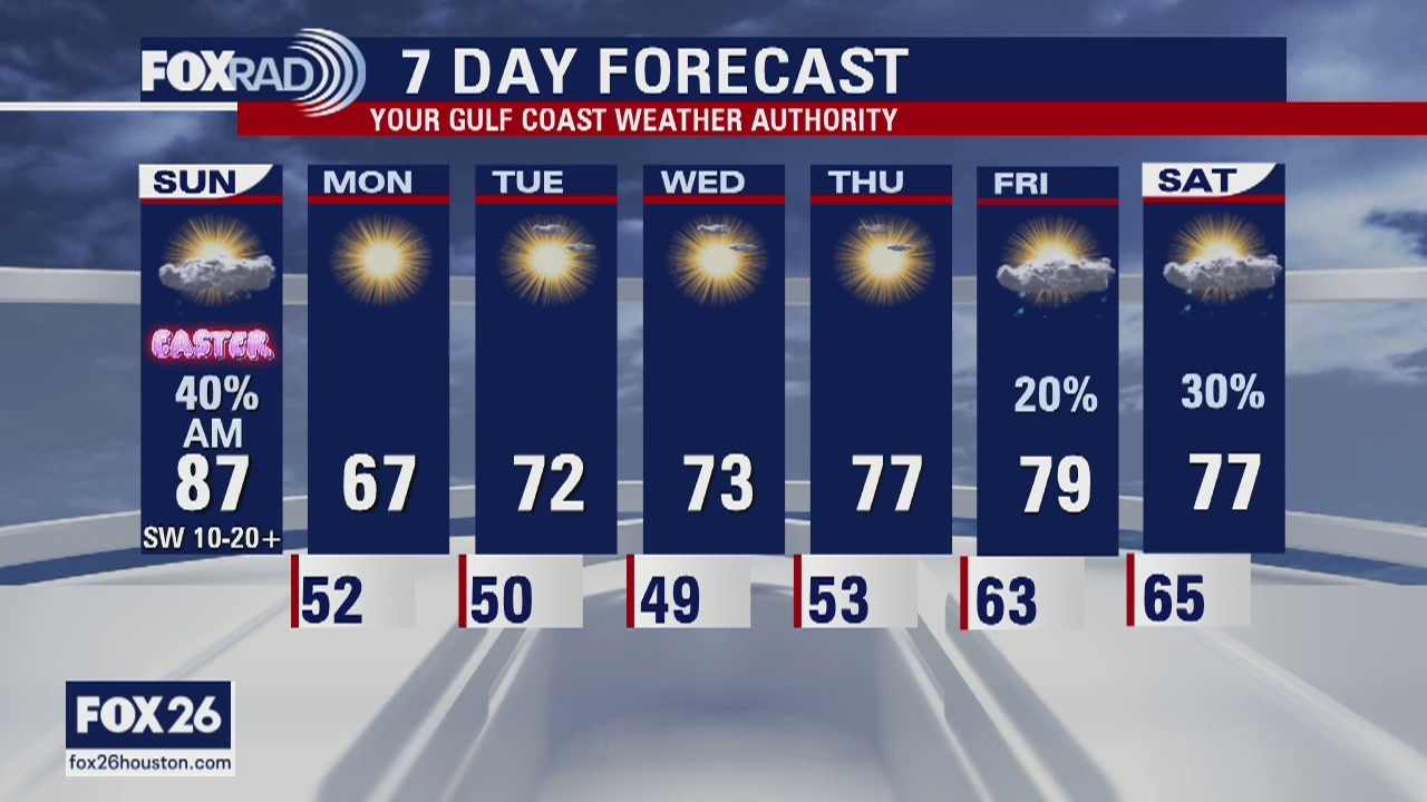
After a round of severe storms Thursday that knocked down trees and dropped 2 to 3 inches of rain in spots, today will be nice and pleasant. Expect a breezy and drier Good Friday with highs in the mid 70s. Unfortunately, storms could make a comeback this Easter weekend. There is a good chance for showers and even a few strong storms from Saturday afternoon through Easter morning.
After a round of severe storms Thursday that knocked down trees and dropped 2 to 3 inches of rain in spots, today will be nice and pleasant. Expect a breezy and drier Good Friday with highs in the mid 70s. Unfortunately, storms could make a comeback this Easter weekend. There is a good chance for showers and even a few strong storms from Saturday afternoon through Easter morning.

Friday Weather Forecast
Your Gulf Coast Weather Authority Chief Meteorologist Dr. Jim Siebert shows you storms headed our way this weekend.
Your Gulf Coast Weather Authority Chief Meteorologist Dr. Jim Siebert shows you storms headed our way this weekend.

Thursday Evening Weather Forecast
Your Gulf Coast Weather Authority Chief Meteorologist Dr. Jim Siebert is tracking storms that are expected to sweep through the Houston area today.
Your Gulf Coast Weather Authority Chief Meteorologist Dr. Jim Siebert is tracking storms that are expected to sweep through the Houston area today.

Thursday morning weather forecast
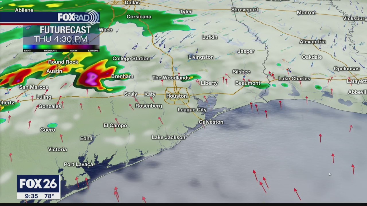
Stay weather alert this evening because strong to severe storms look likely after 5 p.m. A cold front will move in this evening and hail, high winds and heavy rain are possible. Friday will be about 15 degrees cooler and we'll continue with a cooler pattern through the Easter weekend with rainy weather on Saturday and some lingering showers through Sunday morning.
Stay weather alert this evening because strong to severe storms look likely after 5 p.m. A cold front will move in this evening and hail, high winds and heavy rain are possible. Friday will be about 15 degrees cooler and we'll continue with a cooler pattern through the Easter weekend with rainy weather on Saturday and some lingering showers through Sunday morning.
Thursday Early Morning Weather Forecast
Your Gulf Coast Weather Authority Chief Meteorologist Dr. Jim Siebert gives you a look at storms headed our way Thursday.
Your Gulf Coast Weather Authority Chief Meteorologist Dr. Jim Siebert gives you a look at storms headed our way Thursday.
Wednesday Evening Weather Forecast
Your Gulf Coast Weather Authority Chief Meteorologist Dr. Jim Siebert gives you a look at storms heading to the Houston area Thursday.
Your Gulf Coast Weather Authority Chief Meteorologist Dr. Jim Siebert gives you a look at storms heading to the Houston area Thursday.
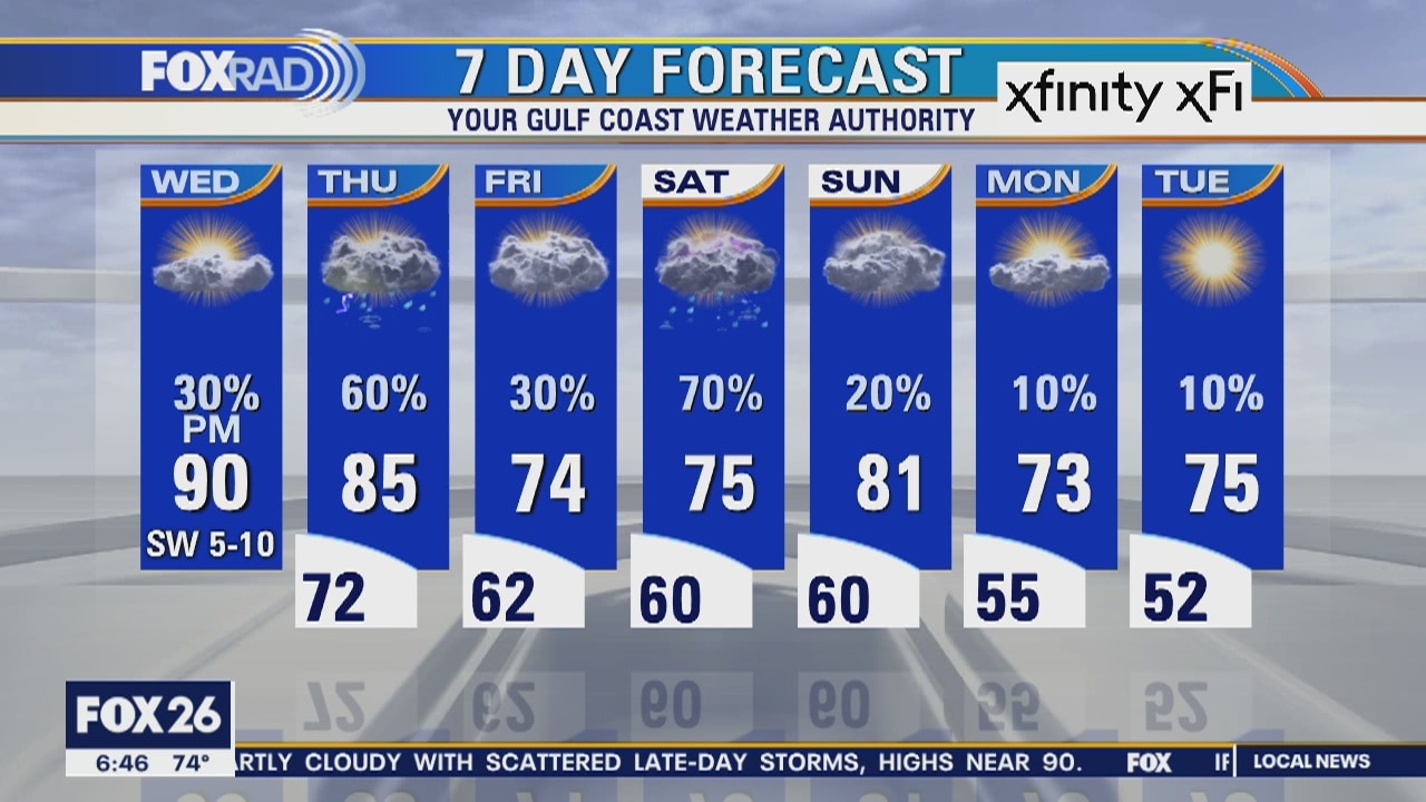
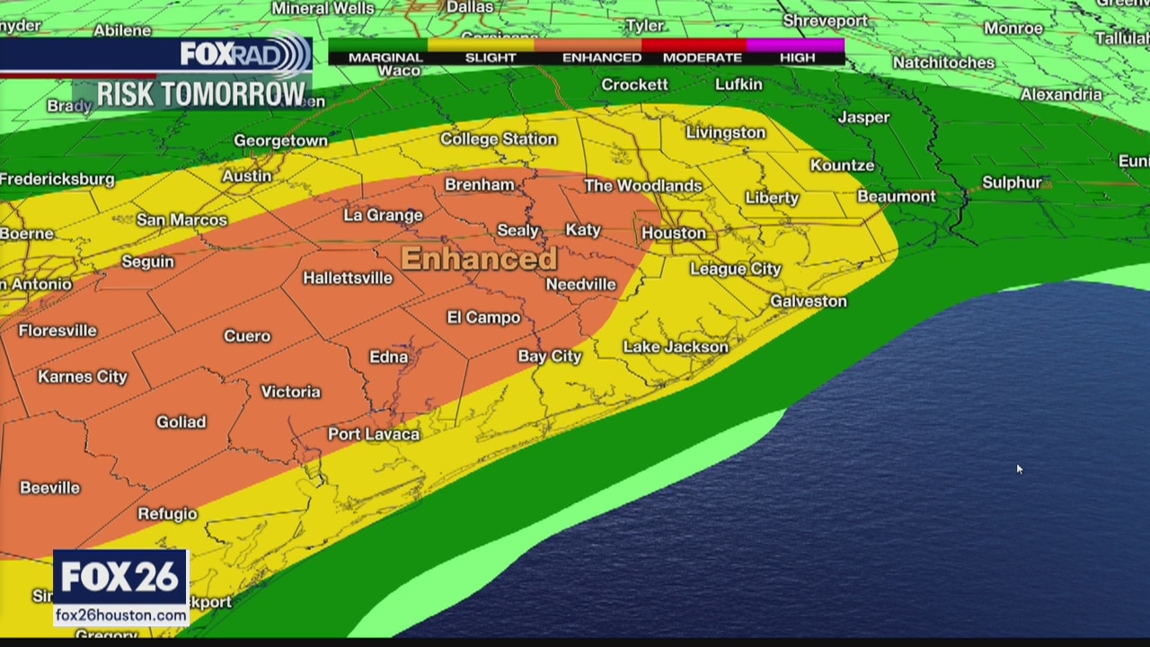
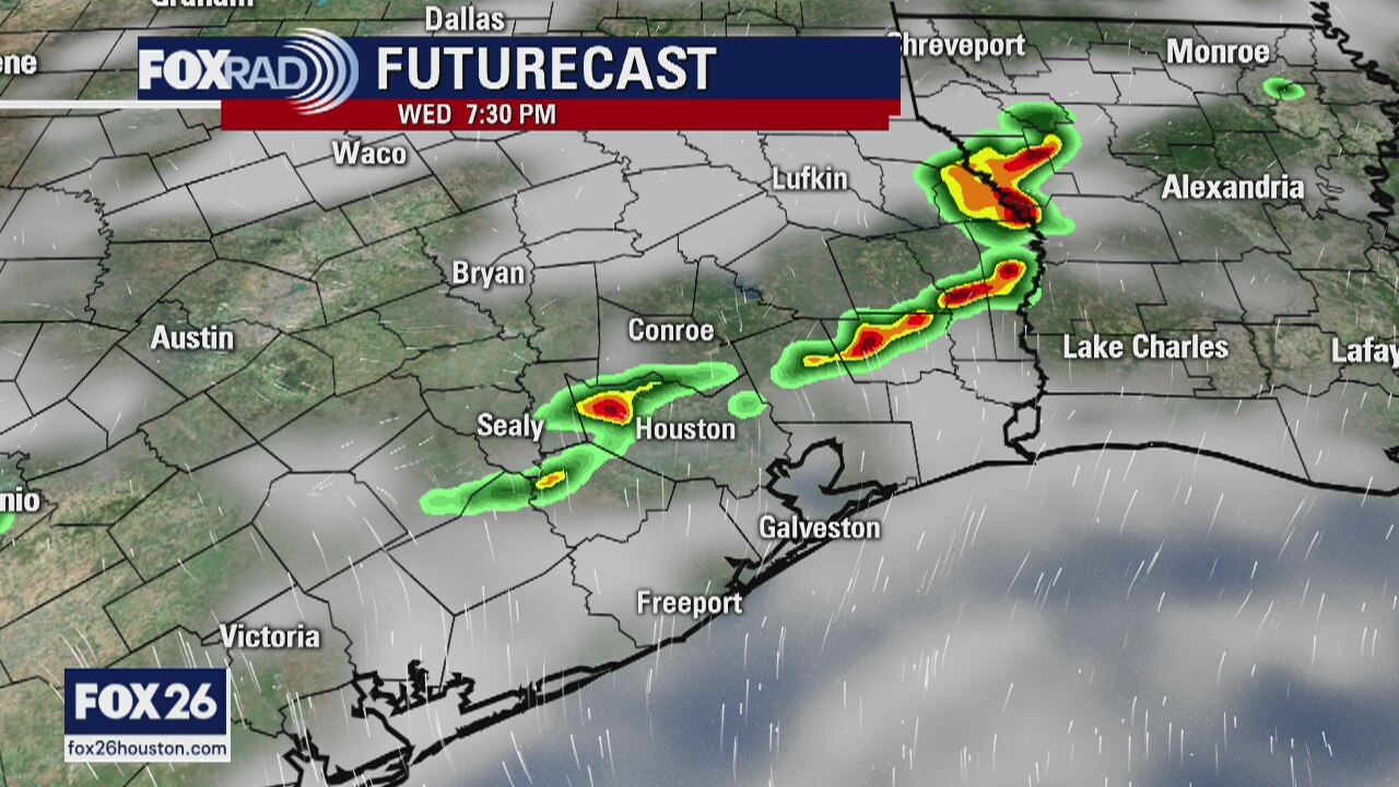
Wednesday morning weather forecast
Get ready for lots of ups and downs in our weather over the next several days. Beginning with today, we're looking for a very warm afternoon with highs near 90, but some late day storms are possible, especially well west/northwest of Houston. Rain is likely on Thursday and again on Saturday as we enter a cooler pattern with highs back in the 70s starting this weekend.
Get ready for lots of ups and downs in our weather over the next several days. Beginning with today, we're looking for a very warm afternoon with highs near 90, but some late day storms are possible, especially well west/northwest of Houston. Rain is likely on Thursday and again on Saturday as we enter a cooler pattern with highs back in the 70s starting this weekend.
Monday evening weather forecast
Wednesday is going to be hot with highs near 90 and there may be a few afternoon storms for our counties north and west of Houston. Rain becomes likely for all on Thur when a front pushes into Texas.
Wednesday is going to be hot with highs near 90 and there may be a few afternoon storms for our counties north and west of Houston. Rain becomes likely for all on Thur when a front pushes into Texas.
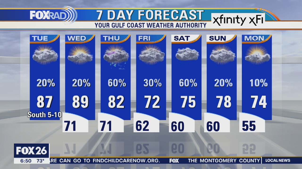
Tuesday morning weather forecast
Steamy weather will move in for today and tomorrow with overnight lows in the 70s and highs in the mid to upper 80s. With high humidity, there may even be a hint of a heat index in the 90s. Only isolated showers are expected today and Wednesday, but a cool front is expected to bring storms on Thursday, a few on Friday and another round on Saturday.
Steamy weather will move in for today and tomorrow with overnight lows in the 70s and highs in the mid to upper 80s. With high humidity, there may even be a hint of a heat index in the 90s. Only isolated showers are expected today and Wednesday, but a cool front is expected to bring storms on Thursday, a few on Friday and another round on Saturday.

Monday night weather forecast
It will be mostly cloudy and mild over the next couple of days and highs by Wed. will be close to 90 degrees. The best chance for rain comes late on Thursday and early into Friday, and at this point, it just looks like a better chance for showers.
It will be mostly cloudy and mild over the next couple of days and highs by Wed. will be close to 90 degrees. The best chance for rain comes late on Thursday and early into Friday, and at this point, it just looks like a better chance for showers.
Monday evening weather forecast
It will be mostly cloudy and mild over the next couple of days and highs by Wed. will be close to 90 degrees. The best chance for rain comes late on Thursday and early into Friday, and at this point, it just looks like a better chance for showers.
It will be mostly cloudy and mild over the next couple of days and highs by Wed. will be close to 90 degrees. The best chance for rain comes late on Thursday and early into Friday, and at this point, it just looks like a better chance for showers.
Monday morning weather forecast
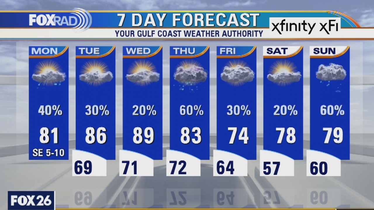
Warmer and more humid air will return slowly over the next couple of days. Look for scattered, mostly light showers today with highs close to 80. Tuesday brings warmer air with highs in the mid 80s and a few isolated storms. Wednesday should be the warmest day of the week as highs approach 90, but that will be followed by another cool front on Thursday.
Warmer and more humid air will return slowly over the next couple of days. Look for scattered, mostly light showers today with highs close to 80. Tuesday brings warmer air with highs in the mid 80s and a few isolated storms. Wednesday should be the warmest day of the week as highs approach 90, but that will be followed by another cool front on Thursday.

Sunday Night Weather Update
Warmer on Monday and rain chances bounce back up to 50%. If you like warm temperatures, Wednesday should be around 90 degrees in southeast Texas.
Warmer on Monday and rain chances bounce back up to 50%. If you like warm temperatures, Wednesday should be around 90 degrees in southeast Texas.

Sunday Evening Weather Update
Warmer on Monday and rain chances bounce back up to 50%. If you like warm temperatures, Wednesday should be around 90 degrees in southeast Texas.
Warmer on Monday and rain chances bounce back up to 50%. If you like warm temperatures, Wednesday should be around 90 degrees in southeast Texas.

Houston area weather forecast 4/5
A cooler start to our Sunday after much needed rainfall on Saturday. We will be mostly dry today. Can't rule out a stray shower in the afternoon, but the chances remain very low. Warmer weather still in store for the week ahead as we will near 90 degrees on Wednesday.
A cooler start to our Sunday after much needed rainfall on Saturday. We will be mostly dry today. Can't rule out a stray shower in the afternoon, but the chances remain very low. Warmer weather still in store for the week ahead as we will near 90 degrees on Wednesday.