

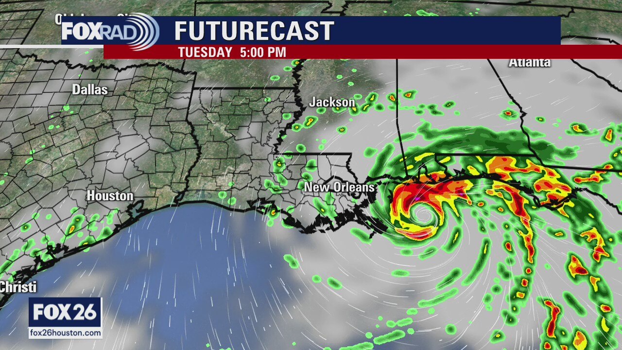
Keeping an eye on Sally
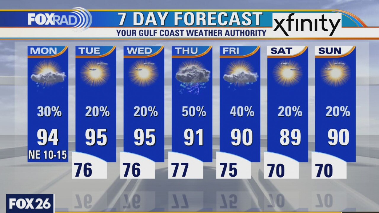
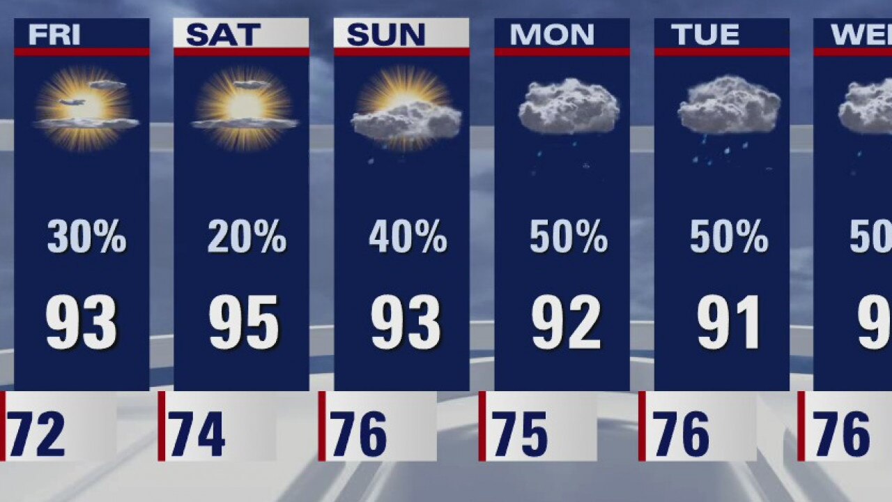
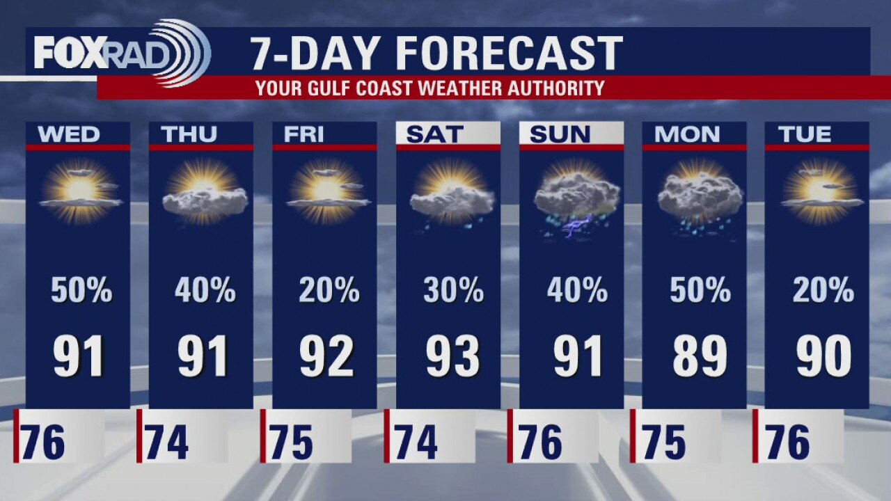
It will be hot and a bit drier for the first half of the week. Hurricane Sally will bring light north winds into southeast Texas and that?s about it. A weak front will approach our region toward the end of the week and will help ease off the heat just a little.
It will be hot and a bit drier for the first half of the week. Hurricane Sally will bring light north winds into southeast Texas and that?s about it. A weak front will approach our region toward the end of the week and will help ease off the heat just a little.

Monday Weather Forecast
It will be hot and a bit drier for the first half of the week. Sally will bring light N winds into SE Texas and that?s about it. A weak front will approach our region toward the end of the week and will help ease off the heat just a little.
It will be hot and a bit drier for the first half of the week. Sally will bring light N winds into SE Texas and that?s about it. A weak front will approach our region toward the end of the week and will help ease off the heat just a little.
Monday weather forecast
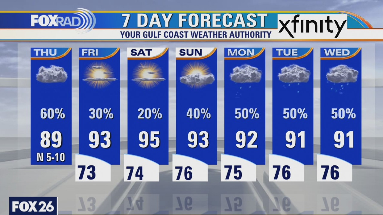
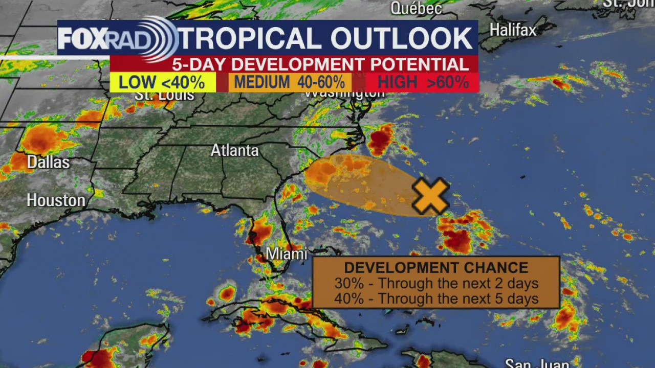
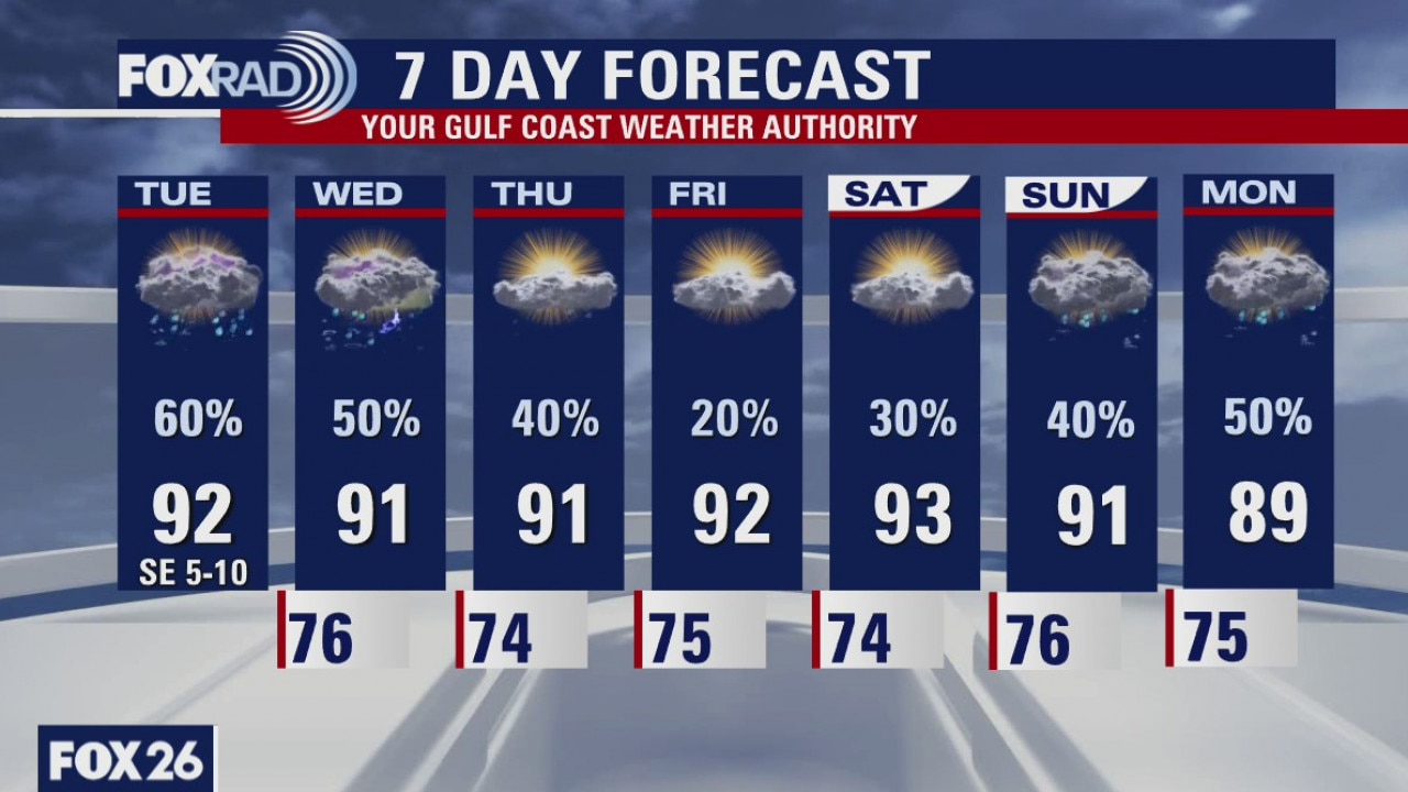
There are five systems spinning in the Atlantic basin; this includes Sally, Teddy, Paulette, Rene and TD21. None of these will have any serious impact our area. Sally will send some higher waves toward our coastline early this week and will likely bring flooding to the northern Gulf Coast. Otherwise, our forecast remains warm and breezy with isolated storms this week.
There are five systems spinning in the Atlantic basin; this includes Sally, Teddy, Paulette, Rene and TD21. None of these will have any serious impact our area. Sally will send some higher waves toward our coastline early this week and will likely bring flooding to the northern Gulf Coast. Otherwise, our forecast remains warm and breezy with isolated storms this week.
Monday morning weather forecast
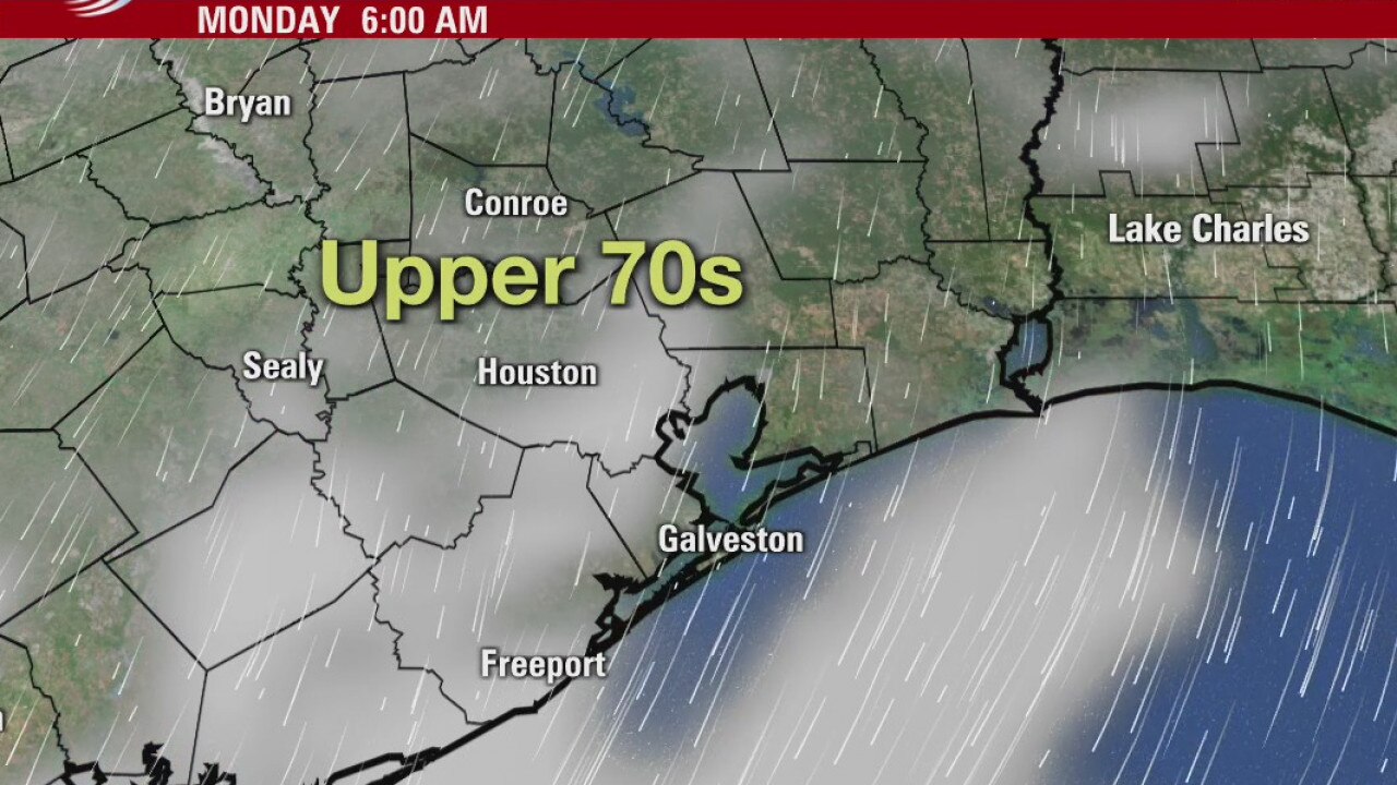
Sally will have very little impacts on us here in Southeast Texas. Rain chances are low until a front will try and make it to Houston towards the end of the week. It will bring increased rain chances and maybe some cooler temperatures.
Sally will have very little impacts on us here in Southeast Texas. Rain chances are low until a front will try and make it to Houston towards the end of the week. It will bring increased rain chances and maybe some cooler temperatures.

Houston-area weather forecast; September 13
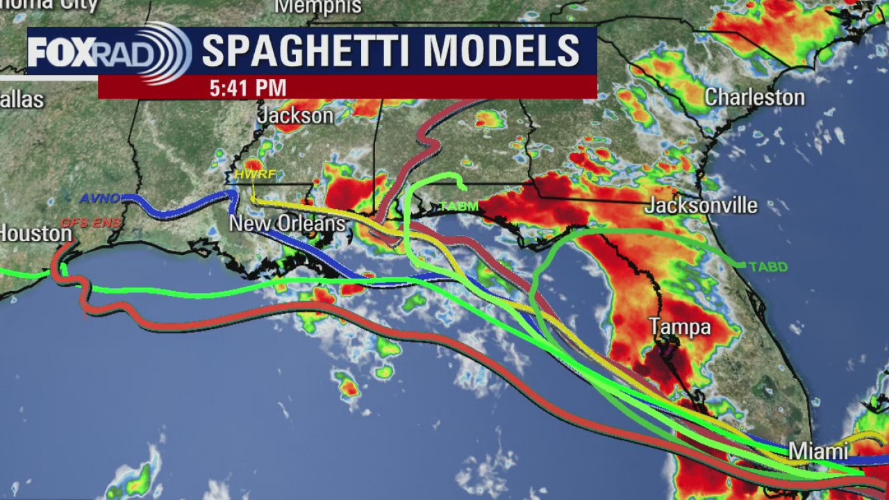
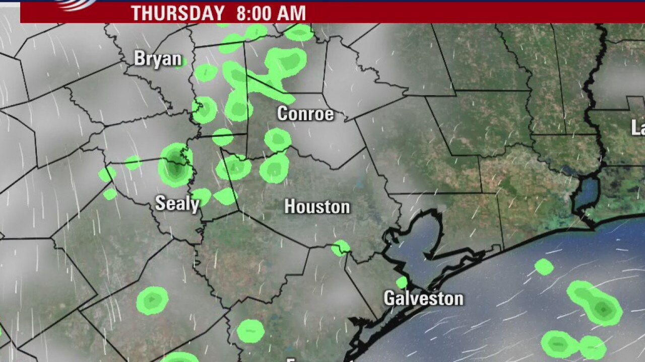
Sunday is starting off muggy and dry, but plan for showers and storms to develop later today as we heat things up across the area. Some brief heavy rain will be possible with a few of the stronger storms. Rain chances will remain for the rest of the week as we wait to see what tropical storm Sally does; as the current forecast has Sally strengthening to a category 2 hurricane before landfall somewhere along the southeastern Louisiana coastline. It remains the case that impacts from Sally appear minimal for residents along the Texas coastline, but it's something we'll still watch.
Sunday is starting off muggy and dry, but plan for showers and storms to develop later today as we heat things up across the area. Some brief heavy rain will be possible with a few of the stronger storms. Rain chances will remain for the rest of the week as we wait to see what tropical storm Sally does; as the current forecast has Sally strengthening to a category 2 hurricane before landfall somewhere along the southeastern Louisiana coastline. It remains the case that impacts from Sally appear minimal for residents along the Texas coastline, but it's something we'll still watch.
Sunday morning weather forecast
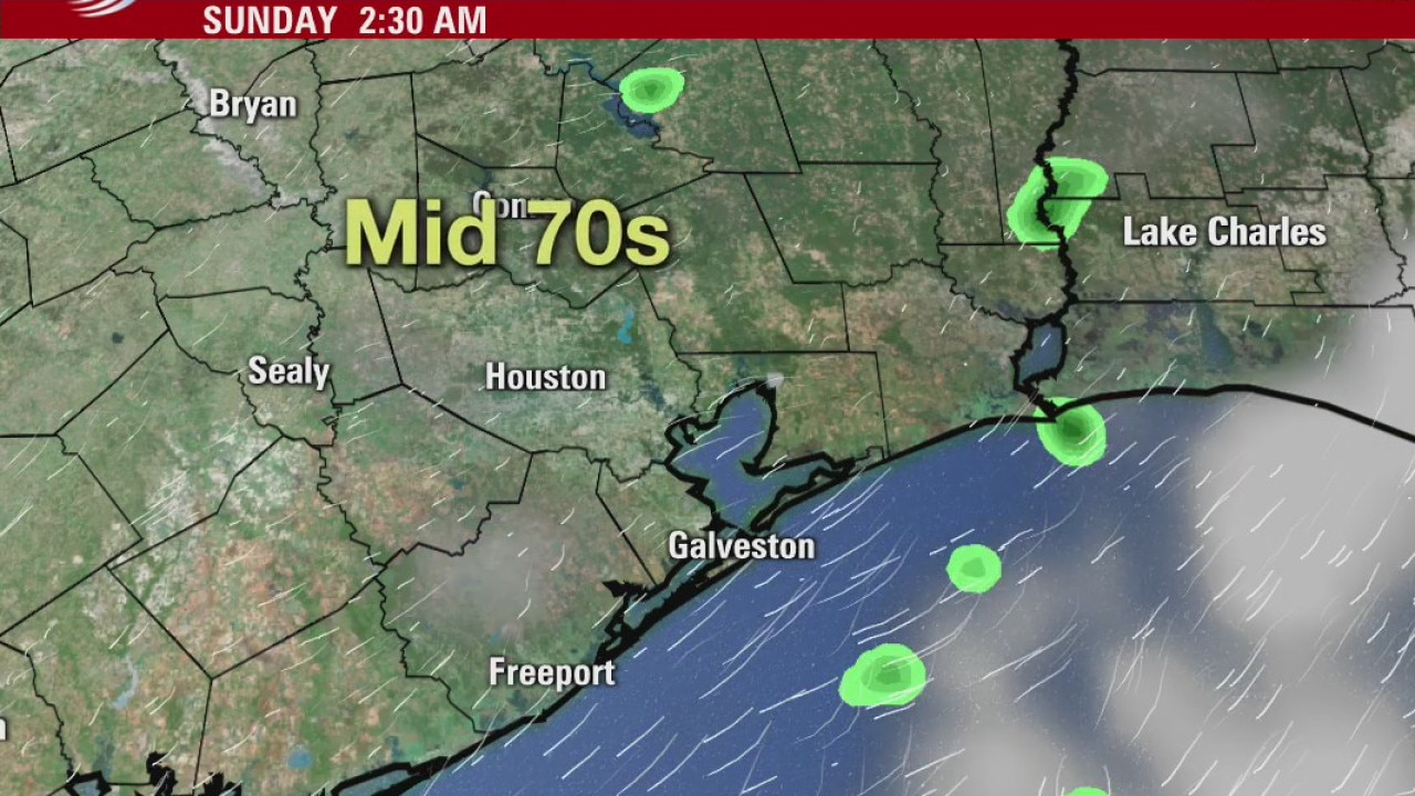
We are continuing to watch Tropical Storm Sally as it moves into the Gulf but confident it will have little impact on Southeast Texas. Also in the Tropics, Tropical Depression Twenty formed way out in the Atlantic. Locally, Houston should see some showers/storms on Sunday afternoon. Look for another round of rain towards the end of the week.
We are continuing to watch Tropical Storm Sally as it moves into the Gulf but confident it will have little impact on Southeast Texas. Also in the Tropics, Tropical Depression Twenty formed way out in the Atlantic. Locally, Houston should see some showers/storms on Sunday afternoon. Look for another round of rain towards the end of the week.
Saturday evening weather forecast
We are continuing to watch Tropical Storm Sally as it moves into the Gulf but confident it will have little impact on Southeast Texas. Also in the Tropics, Tropical Depression Twenty formed way out in the Atlantic. Locally, Houston should see some showers/storms on Sunday afternoon. Look for another round of rain towards the end of the week.
We are continuing to watch Tropical Storm Sally as it moves into the Gulf but confident it will have little impact on Southeast Texas. Also in the Tropics, Tropical Depression Twenty formed way out in the Atlantic. Locally, Houston should see some showers/storms on Sunday afternoon. Look for another round of rain towards the end of the week.

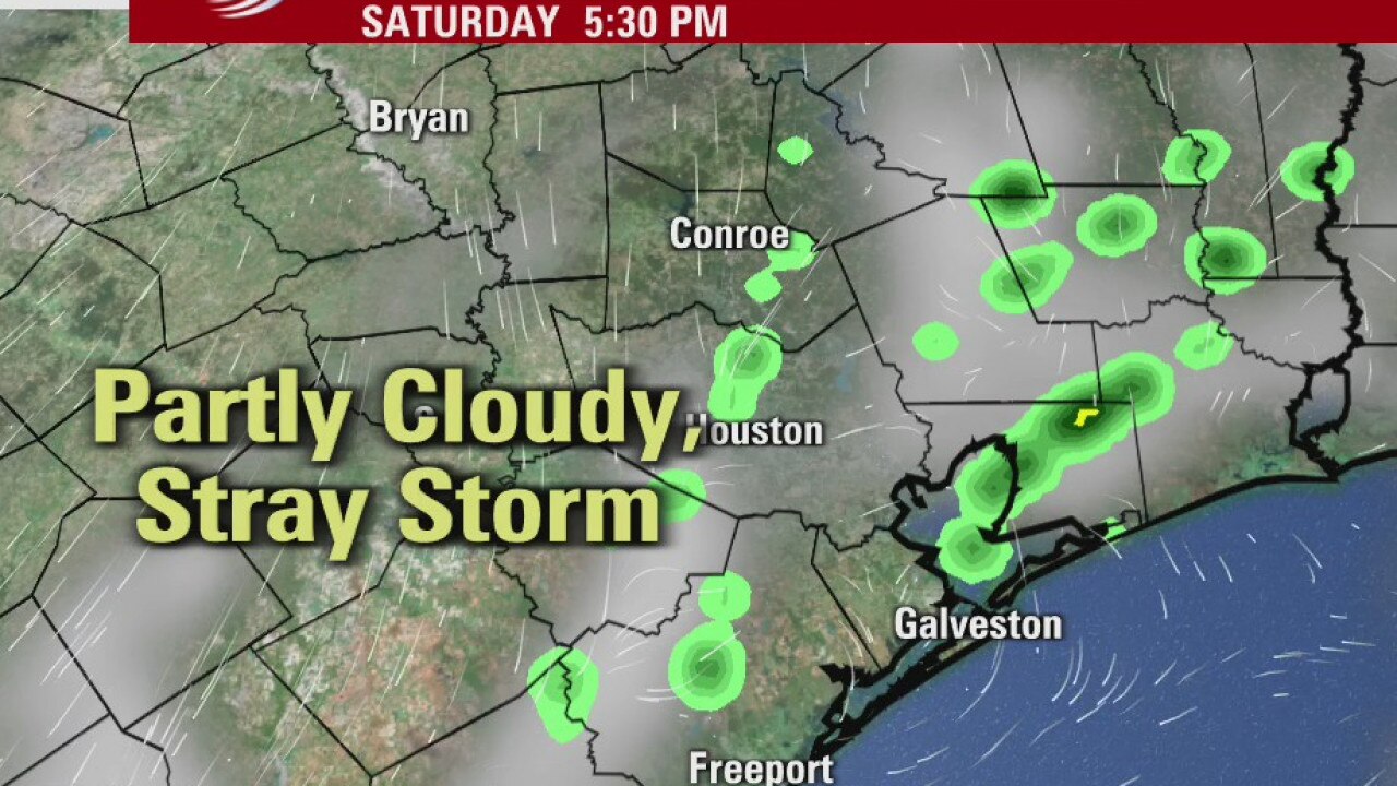
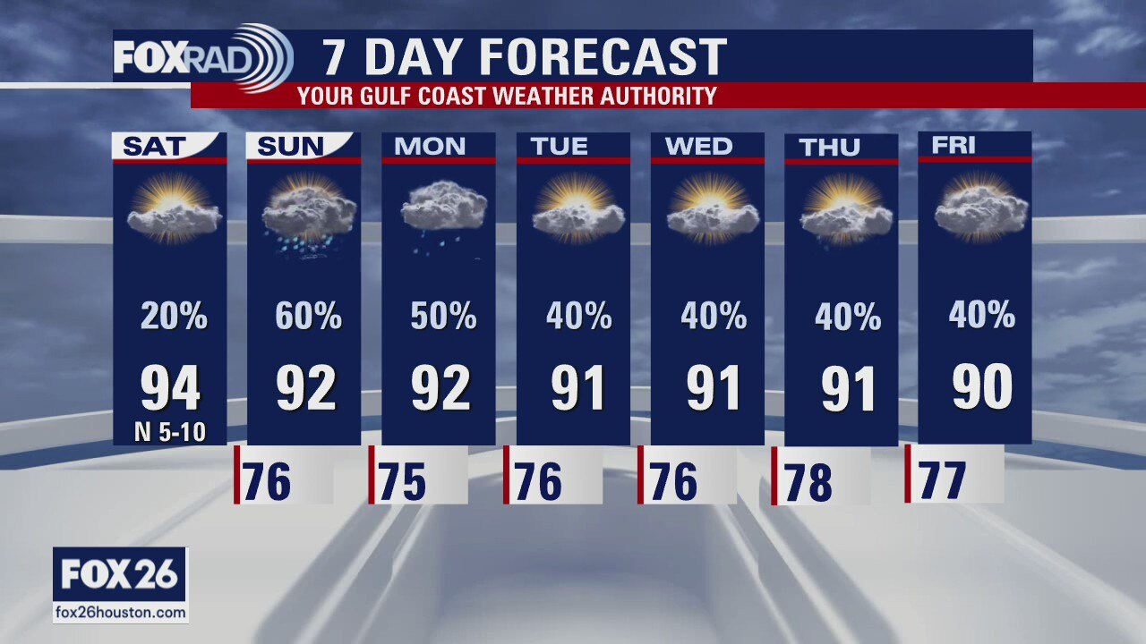
Saturday Weather Forecast
The weekend is starting off dry and pleasant with temperatures expected to warm into the low and mid 90s today. Rain chances will increase a bit this afternoon, but higher chances arrive on Sunday. An area of disturbed weather in the Gulf will keep our rain chances higher through Monday and then our attention will turn to Tropical Depression 19. The forecast keeps Houston and the entire Texas coast free of any landfall concern and the more this system organizes, the less likely our chances for rain look by the middle and late part of the week. Regardless, we'll keep about a 40% chance after Monday.
The weekend is starting off dry and pleasant with temperatures expected to warm into the low and mid 90s today. Rain chances will increase a bit this afternoon, but higher chances arrive on Sunday. An area of disturbed weather in the Gulf will keep our rain chances higher through Monday and then our attention will turn to Tropical Depression 19. The forecast keeps Houston and the entire Texas coast free of any landfall concern and the more this system organizes, the less likely our chances for rain look by the middle and late part of the week. Regardless, we'll keep about a 40% chance after Monday.
Houston-area weather forecast 9-12
The weekend is starting off dry and pleasant with temperatures expected to warm into the low and mid 90s today. Rain chances will increase a bit this afternoon, but higher chances arrive on Sunday. An area of disturbed weather in the Gulf will keep our rain chances higher through Monday and then our attention will turn to Tropical Depression 19. The forecast keeps Houston and the entire Texas coast free of any landfall concern and the more this system organizes, the less likely our chances for rain look by the middle and late part of the week. Regardless, we'll keep about a 40% chance after Monday.
The weekend is starting off dry and pleasant with temperatures expected to warm into the low and mid 90s today. Rain chances will increase a bit this afternoon, but higher chances arrive on Sunday. An area of disturbed weather in the Gulf will keep our rain chances higher through Monday and then our attention will turn to Tropical Depression 19. The forecast keeps Houston and the entire Texas coast free of any landfall concern and the more this system organizes, the less likely our chances for rain look by the middle and late part of the week. Regardless, we'll keep about a 40% chance after Monday.
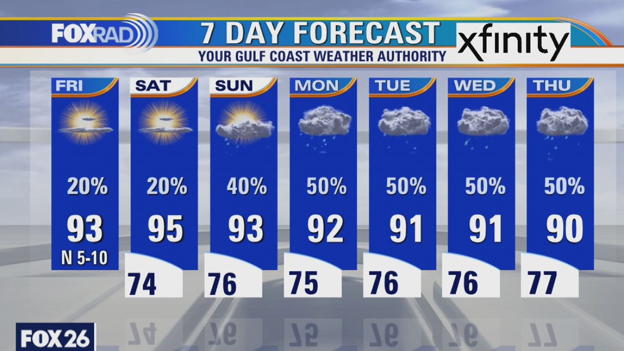
Friday Evening Weather Forecast
Tropical Depression 19 has formed near Florida with winds at 35 mph. It is expected to become a tropical storm in the Gulf and make landfall near Louisiana and Mississippi. It will have little impact on SE Texas, but you?ve got to feel sorry for the folks who are going to get hit again.
Tropical Depression 19 has formed near Florida with winds at 35 mph. It is expected to become a tropical storm in the Gulf and make landfall near Louisiana and Mississippi. It will have little impact on SE Texas, but you?ve got to feel sorry for the folks who are going to get hit again.
Friday weather forecast
We started out with a few early morning showers, but skies will clear later this morning and temperatures will warm in the low 90s. We will probably see a few storms develop this afternoon as the stationary front continues to weaken over the area. Weekend, overall, is looking warm with rain chances slightly higher on Sunday compared to Saturday.
We started out with a few early morning showers, but skies will clear later this morning and temperatures will warm in the low 90s. We will probably see a few storms develop this afternoon as the stationary front continues to weaken over the area. Weekend, overall, is looking warm with rain chances slightly higher on Sunday compared to Saturday.
Friday morning weather forecast
Rain chances will drop a bit over the next couple of days, but next week will bring more showers to the area. The possible tropical lows in the Gulf aren?t expected to be a problem for us, but will send more humidity into the Houston area next week. That will lead to more on-and-off showers.
Rain chances will drop a bit over the next couple of days, but next week will bring more showers to the area. The possible tropical lows in the Gulf aren?t expected to be a problem for us, but will send more humidity into the Houston area next week. That will lead to more on-and-off showers.
Thursday weather forecast
Some excitement today as our much advertised cold front actually arrived for areas west of Houston. A complicated forecast is setting up for this afternoon with low 90s east, 70s west and rain likely for Houston. Warmer highs lie ahead for Friday and Saturday followed by a tropical wave and higher rain chances for much of next week.
Some excitement today as our much advertised cold front actually arrived for areas west of Houston. A complicated forecast is setting up for this afternoon with low 90s east, 70s west and rain likely for Houston. Warmer highs lie ahead for Friday and Saturday followed by a tropical wave and higher rain chances for much of next week.
Thursday morning weather forecast
There aren?t any big changes to our forecast as the front we?ve been hoping for seems to be staying away. That means more highs in the low 90s and more scattered showers. We will keep our eye on the eastern Gulf this weekend where some disorganized showers have a 20% chance of developing into something. We will watch it closely.
There aren?t any big changes to our forecast as the front we?ve been hoping for seems to be staying away. That means more highs in the low 90s and more scattered showers. We will keep our eye on the eastern Gulf this weekend where some disorganized showers have a 20% chance of developing into something. We will watch it closely.

Wednesday Weather Forecast
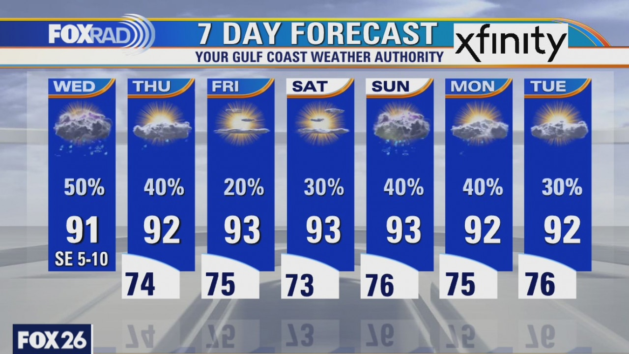
Following another round of scattered downpours today, our forecast should remain warm and humid through this weekend. A strong early season cold front brought snow to the Texas panhandle today while areas along the coast were well into the 90s. Look for highs in the low to mid 90s through the weekend with isolated mainly afternoon showers and storms. Paulette and Rene are tropical storms in the far Atlantic and will not affect Texas.
Following another round of scattered downpours today, our forecast should remain warm and humid through this weekend. A strong early season cold front brought snow to the Texas panhandle today while areas along the coast were well into the 90s. Look for highs in the low to mid 90s through the weekend with isolated mainly afternoon showers and storms. Paulette and Rene are tropical storms in the far Atlantic and will not affect Texas.
Wednesday weather forecast
The variety of weather across Texas today is pretty wild, especially for early September. There is light snow and wind chills in the 20s in the Texas panhandle while the heat index along the coast could hit 100. Watch for scattered storms here today, especially west of I-45 I the highs in the low 90s and a similar forecast through the weekend.
The variety of weather across Texas today is pretty wild, especially for early September. There is light snow and wind chills in the 20s in the Texas panhandle while the heat index along the coast could hit 100. Watch for scattered storms here today, especially west of I-45 I the highs in the low 90s and a similar forecast through the weekend.
Wednesday Morning Weather Forecast
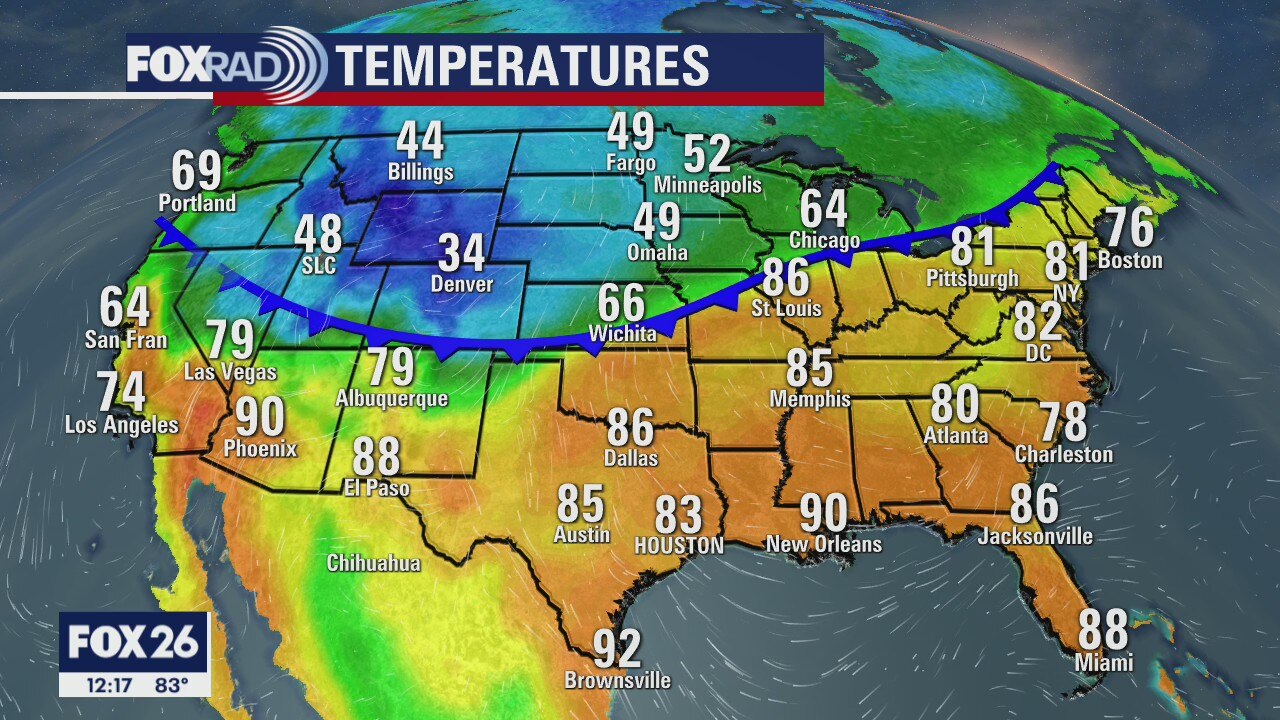
It?s 84 in Houston and 44 in Amarillo. That?s crazy, but check out Abilene where it?s 85 degrees and just down the road from Amarillo. This is why I love trying to forecast the weather in Texas! By the way, that nice cool and drier air isn?t going to make it to Houston this go around. Bummer! - Dr. Jim Siebert
It?s 84 in Houston and 44 in Amarillo. That?s crazy, but check out Abilene where it?s 85 degrees and just down the road from Amarillo. This is why I love trying to forecast the weather in Texas! By the way, that nice cool and drier air isn?t going to make it to Houston this go around. Bummer! - Dr. Jim Siebert
Tuesday weather forecast
The front is slowing, which is bad news for us. It won?t be cool, but it will at least be cooler. Highs in the low 90s and lows in the 70s. If you need to feel a chill, take a quick trip to Amarillo where it?s currently in the 40s!
The front is slowing, which is bad news for us. It won?t be cool, but it will at least be cooler. Highs in the low 90s and lows in the 70s. If you need to feel a chill, take a quick trip to Amarillo where it?s currently in the 40s!
Tuesday weather forecast
Scattered showers and storms look likely today and tomorrow with partly sunny and warm conditions in between. Our much anticipated cold front looks like it will stall just to our northwest. Still, clouds and rain will help to tamp down temperatures a bit, so look for highs in the Upper 80s and low 90s with lows in the mid 70s.
Scattered showers and storms look likely today and tomorrow with partly sunny and warm conditions in between. Our much anticipated cold front looks like it will stall just to our northwest. Still, clouds and rain will help to tamp down temperatures a bit, so look for highs in the Upper 80s and low 90s with lows in the mid 70s.
Weather forecast- Tuesday Sept. 8 Noon
Meteorologist John Dawson with the noon weather and forecast for the rest of the day and the coming week. Scattered showers for a few more days.
Meteorologist John Dawson with the noon weather and forecast for the rest of the day and the coming week. Scattered showers for a few more days.