

Houston-area weather forecast 12/27
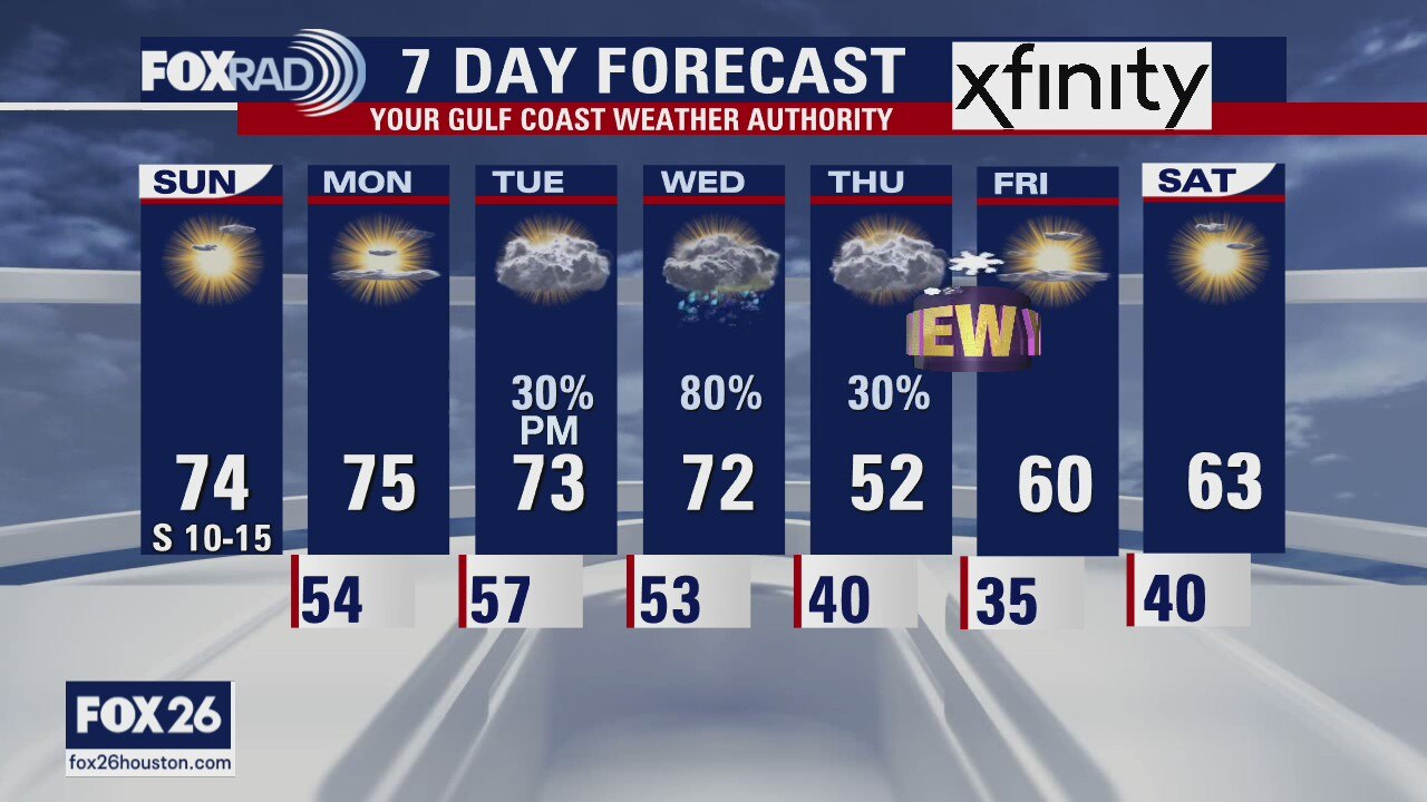
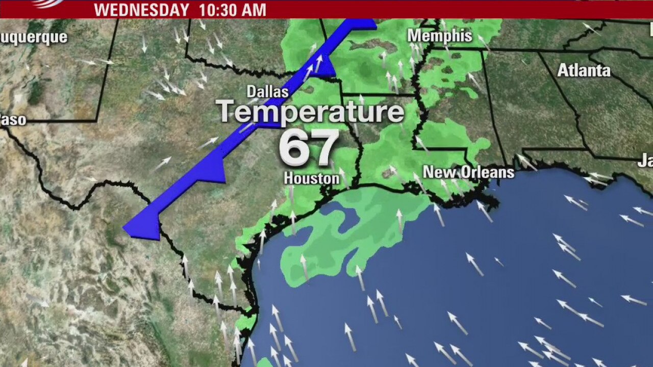
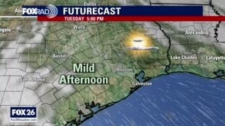
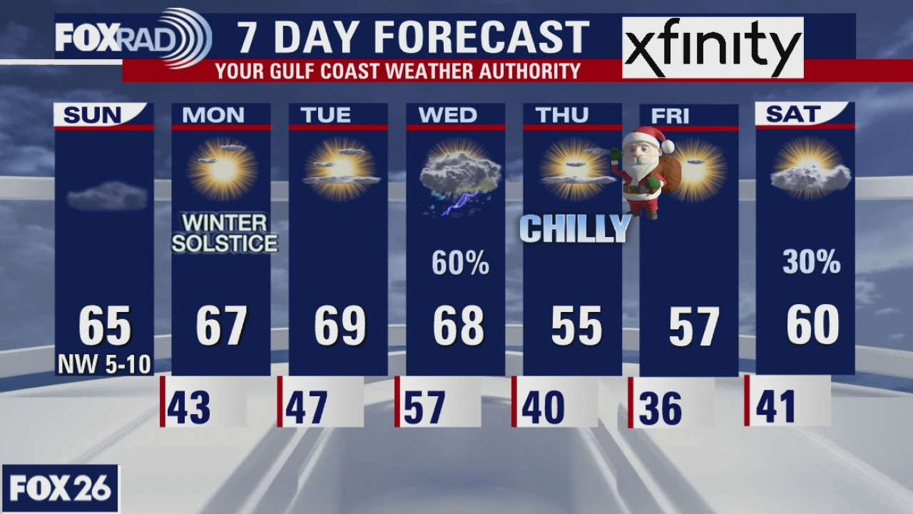
Our streak of warmer-than-average high temperatures continues today with a mix of sun and clouds and a noticeable south wind. Highs in Houston should reach the low, maybe even mid 70s. Changes are set to arrive on Wednesday with a cold front that will move through. Temperatures will likely top off in 70s until then. As we head into the new year, we'll begin much cooler with highs, behind the front, only reaching the 50s and 60s with lows, Friday morning, in the mid 30s!
Our streak of warmer-than-average high temperatures continues today with a mix of sun and clouds and a noticeable south wind. Highs in Houston should reach the low, maybe even mid 70s. Changes are set to arrive on Wednesday with a cold front that will move through. Temperatures will likely top off in 70s until then. As we head into the new year, we'll begin much cooler with highs, behind the front, only reaching the 50s and 60s with lows, Friday morning, in the mid 30s!
Houston-area weather forecast 12/26
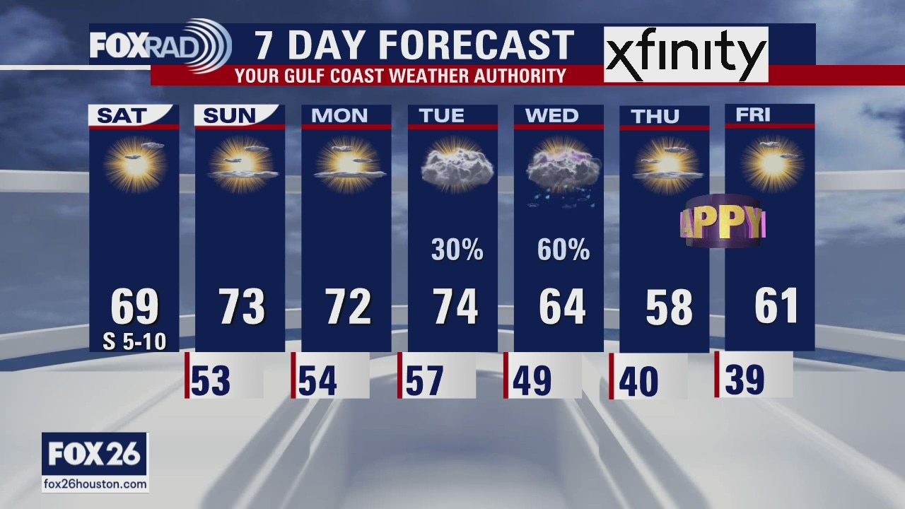
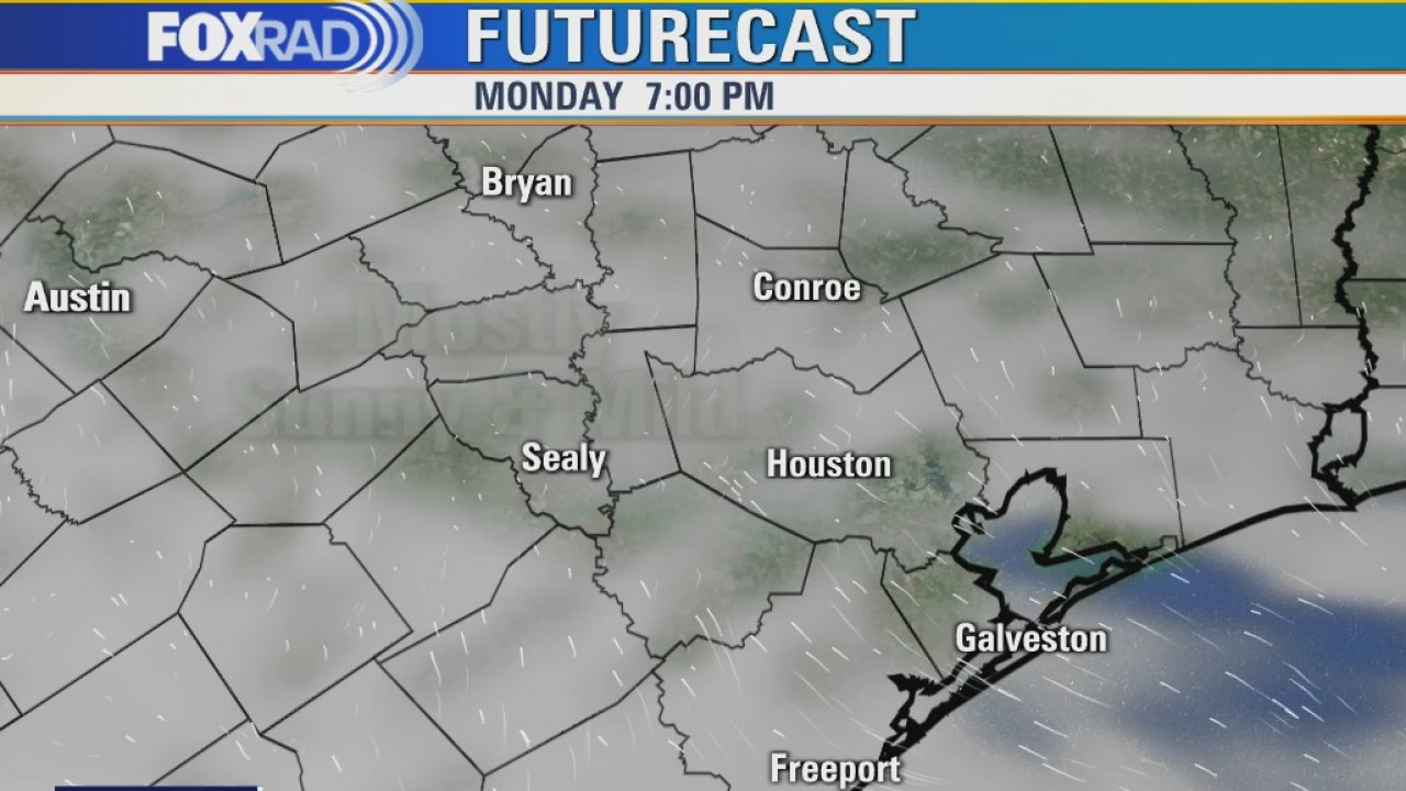
Chilly mornings will give way to pleasant temperatures on Saturday and Sunday with highs likely reaching the upper 60s and low 70s. We'll start off the final week of 2020 on the warmer side, but a cold front should be moving through the region, once again, on Wednesday and drop those temperatures back just in time for 2021. Rain and storm chances are looking more and more likely with the next frontal passage on Wednesday, but otherwise rainfall should remain limited over the next several days.
Chilly mornings will give way to pleasant temperatures on Saturday and Sunday with highs likely reaching the upper 60s and low 70s. We'll start off the final week of 2020 on the warmer side, but a cold front should be moving through the region, once again, on Wednesday and drop those temperatures back just in time for 2021. Rain and storm chances are looking more and more likely with the next frontal passage on Wednesday, but otherwise rainfall should remain limited over the next several days.
Friday Evening Weather Forecast
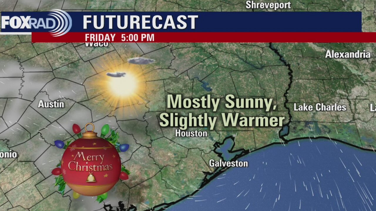
The day after Christmas will start off chilly, but highs will reach back into the 60s in the afternoon. Sunday and Monday will be in the 70s. The next front arrives on Wednesday and that will cool the air heading into the 2021.
The day after Christmas will start off chilly, but highs will reach back into the 60s in the afternoon. Sunday and Monday will be in the 70s. The next front arrives on Wednesday and that will cool the air heading into the 2021.
A chilly start to Christmas Day
A very merry and chilly start to our Christmas with temperatures dipping into the 30s this morning. Skies will remain clear this afternoon so expect those temperatures to warm a little more than what we saw on Christmas Eve. Winds won't be nearly as strong either. Highs today should reach the low 60s. Clouds may return later this evening, keeping temperatures slightly warmer but it will still be chilly. 70s could potentially return as early as Sunday as rain chances hang off until Monday.
A very merry and chilly start to our Christmas with temperatures dipping into the 30s this morning. Skies will remain clear this afternoon so expect those temperatures to warm a little more than what we saw on Christmas Eve. Winds won't be nearly as strong either. Highs today should reach the low 60s. Clouds may return later this evening, keeping temperatures slightly warmer but it will still be chilly. 70s could potentially return as early as Sunday as rain chances hang off until Monday.
Thursday Evening Weather Forecast
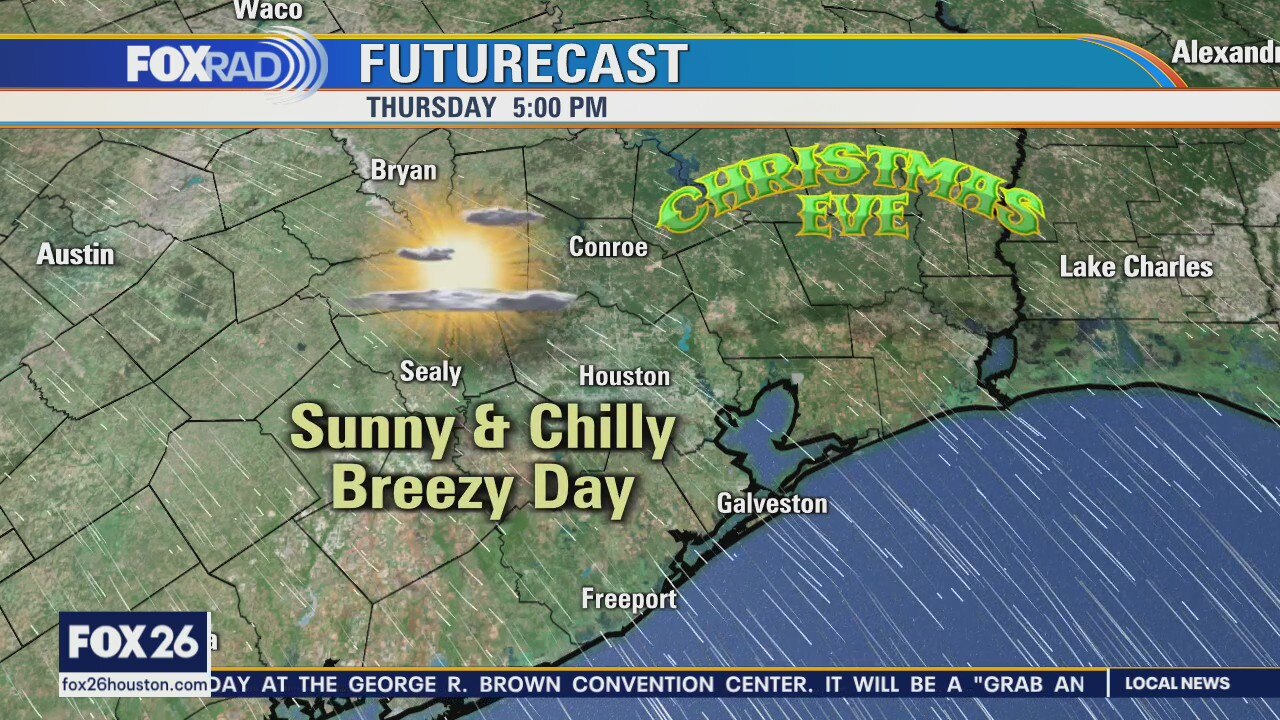
Christmas Day looks clear and cold across Houston. Look for a slow warming trend starting on Saturday. Our next shot for rain will come on Tuesday or Wednesday as another cold front will approach and move through Southeast Texas.
Christmas Day looks clear and cold across Houston. Look for a slow warming trend starting on Saturday. Our next shot for rain will come on Tuesday or Wednesday as another cold front will approach and move through Southeast Texas.
A chilly Christmas Eve
A blustery start on this Christmas Eve with most areas dipping into the upper 30s and low 40s. Wind chill values, at time, have dropped below freezing! Windy conditions will persist through the morning with a wind advisory remaining in place for most of the area until 9 a.m. Highs, today, will struggle to reach the 50s. Christmas Day will start off cold, but with calmer winds and sunny skies we should warm into the low 60s. Next slight chance of rain will arrive on Sunday, but our best shot will come on Wednesday as another cold front is set to move through.
A blustery start on this Christmas Eve with most areas dipping into the upper 30s and low 40s. Wind chill values, at time, have dropped below freezing! Windy conditions will persist through the morning with a wind advisory remaining in place for most of the area until 9 a.m. Highs, today, will struggle to reach the 50s. Christmas Day will start off cold, but with calmer winds and sunny skies we should warm into the low 60s. Next slight chance of rain will arrive on Sunday, but our best shot will come on Wednesday as another cold front is set to move through.

Thursday morning weather forecast
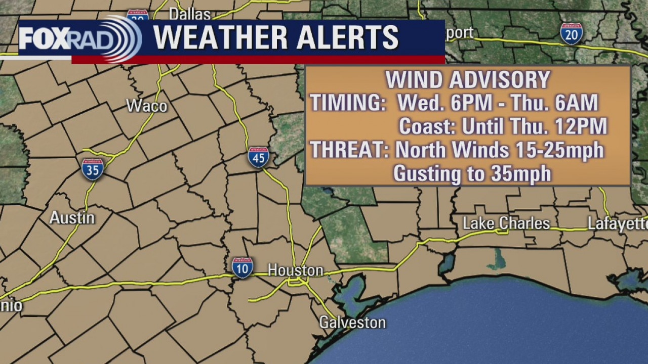
A Wind Advisory is in effect for most of the region through Thursday morning. Look for chilly temps for both Christmas Eve and Christmas Day.
A Wind Advisory is in effect for most of the region through Thursday morning. Look for chilly temps for both Christmas Eve and Christmas Day.
Wednesday Evening Weather Forecast
A front Wednesday evening brings big changes to the mild weather Houston has seen this week. A Wind Advisory is in effect for most of the region through Thursday morning. Look for chilly temps for both Christmas Eve and Christmas Day.
A front Wednesday evening brings big changes to the mild weather Houston has seen this week. A Wind Advisory is in effect for most of the region through Thursday morning. Look for chilly temps for both Christmas Eve and Christmas Day.
Prepare for a cold front this evening
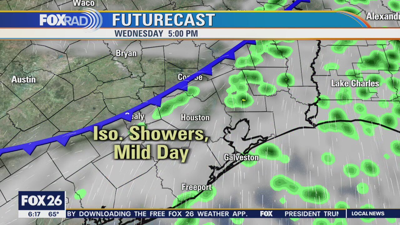
We're waiting on a cold front that is expected to move through later this evening. Until then, temperatures will warm this afternoon into the mid, even upper, 70s. Rain chances increase, mainly after 4 p.m. as a thin line of rain and storms will likely form along and ahead of the cold front. A wind advisory will then go into effect for much of the region, beginning at 6 p.m. Strong north winds will persist through Thursday morning with some gusts reaching 35mph+. After Wednesday's cold front, cooler temperatures will prevail until this weekend when a slight warming trend is expected.
We're waiting on a cold front that is expected to move through later this evening. Until then, temperatures will warm this afternoon into the mid, even upper, 70s. Rain chances increase, mainly after 4 p.m. as a thin line of rain and storms will likely form along and ahead of the cold front. A wind advisory will then go into effect for much of the region, beginning at 6 p.m. Strong north winds will persist through Thursday morning with some gusts reaching 35mph+. After Wednesday's cold front, cooler temperatures will prevail until this weekend when a slight warming trend is expected.
Wednesday morning weather forecast
Get ready for a big change in this mild weather pattern we have been enjoying in the Houston area. A cold front will bring showers and storms Wednesday afternoon followed by a big drop in temperatures. Christmas Eve morning is looking windy and cold. Christmas morning will be even colder with some frost around the area and temperatures near freezing.
Get ready for a big change in this mild weather pattern we have been enjoying in the Houston area. A cold front will bring showers and storms Wednesday afternoon followed by a big drop in temperatures. Christmas Eve morning is looking windy and cold. Christmas morning will be even colder with some frost around the area and temperatures near freezing.
Tuesday Evening Weather Forecast
Get ready for a big change in this mild weather pattern we have been enjoying in the Houston area. A cold front will bring showers and storms Wednesday afternoon followed by a big drop in temperatures. Christmas Eve morning is looking windy and cold. Christmas morning will be even colder with some frost around the area and temperatures near freezing.
Get ready for a big change in this mild weather pattern we have been enjoying in the Houston area. A cold front will bring showers and storms Wednesday afternoon followed by a big drop in temperatures. Christmas Eve morning is looking windy and cold. Christmas morning will be even colder with some frost around the area and temperatures near freezing.
Prepare for Wednesday's cold front
Christmas weather will be much different than what we?re seeing today. Look for a breezy afternoon today with highs in the low 70s. A cold front will bring showers and storms by Wednesday afternoon followed by a big drop in temperatures. Christmas Eve morning is looking windy and cold and Christmas morning will likely bring temps chilly enough for some frost, but certainly no snow.
Christmas weather will be much different than what we?re seeing today. Look for a breezy afternoon today with highs in the low 70s. A cold front will bring showers and storms by Wednesday afternoon followed by a big drop in temperatures. Christmas Eve morning is looking windy and cold and Christmas morning will likely bring temps chilly enough for some frost, but certainly no snow.
Tuesday morning weather forecast
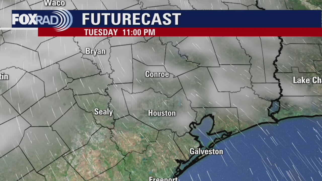
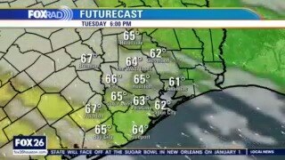
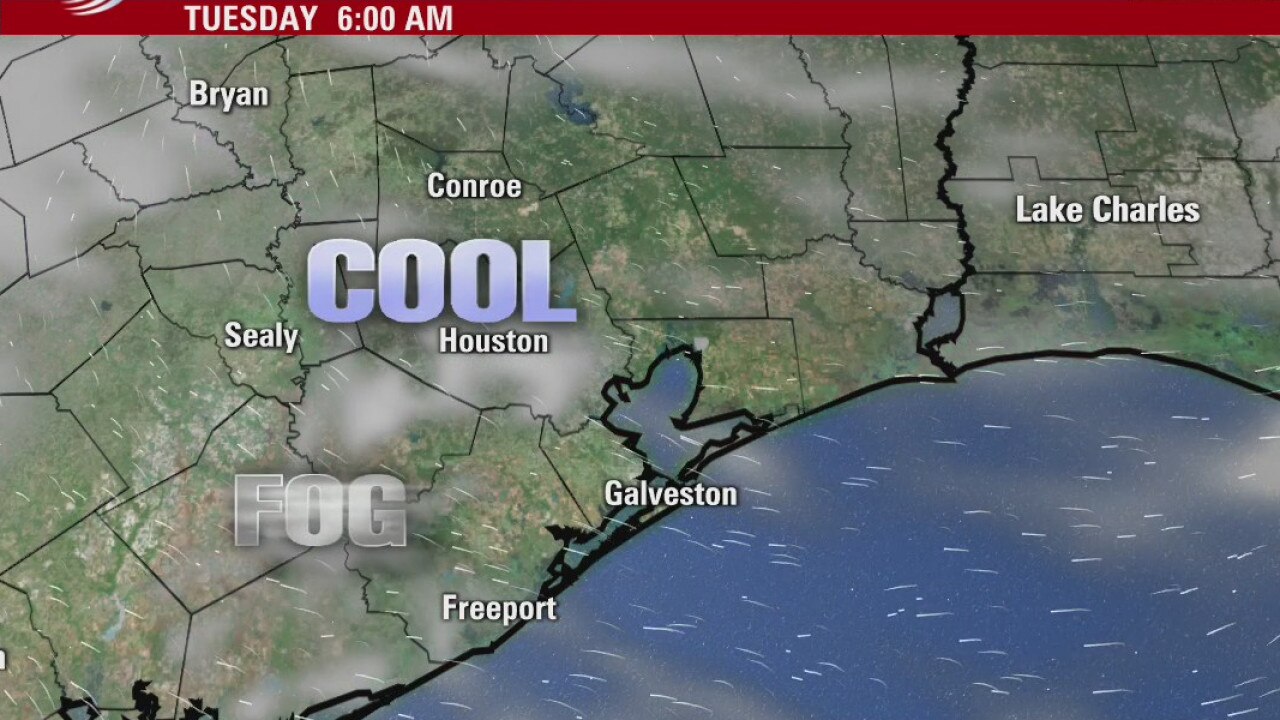
There will be more fog around Houston on Tuesday morning followed by more sunshine and pleasant temperatures in the afternoon. Our next cold front will move in Wednesday. Expect a quick round of rain followed by a windy and cooler evening. Dry and chilly weather hang around Southeast Texas for Christmas Eve and Christmas Day.
There will be more fog around Houston on Tuesday morning followed by more sunshine and pleasant temperatures in the afternoon. Our next cold front will move in Wednesday. Expect a quick round of rain followed by a windy and cooler evening. Dry and chilly weather hang around Southeast Texas for Christmas Eve and Christmas Day.
Dry and chilly weather ahead
There will be more fog around Houston on Tuesday morning followed by more sunshine and pleasant temperatures in the afternoon. Our next cold front will move in on Wednesday. Expect a quick round of rain followed by a windy and cooler evening. Dry and chilly weather hang around Southeast Texas for Christmas Eve and Christmas Day.
There will be more fog around Houston on Tuesday morning followed by more sunshine and pleasant temperatures in the afternoon. Our next cold front will move in on Wednesday. Expect a quick round of rain followed by a windy and cooler evening. Dry and chilly weather hang around Southeast Texas for Christmas Eve and Christmas Day.
Monday Weather Forecast
After some morning fog, today is looking very nice. Tuesday looks good as well, then our next cold front will move in Wednesday. Expect a brief round of rain followed by a windy and colder weather Wednesday evening and a chilly pattern for Christmas Eve and Christmas Day.
After some morning fog, today is looking very nice. Tuesday looks good as well, then our next cold front will move in Wednesday. Expect a brief round of rain followed by a windy and colder weather Wednesday evening and a chilly pattern for Christmas Eve and Christmas Day.
Sunday's weather and a look ahead
Mike Iscovitz brings you today's weather forecast and a look ahead to Christmas day. (Hint: sweaters might be a good gift this year)
Mike Iscovitz brings you today's weather forecast and a look ahead to Christmas day. (Hint: sweaters might be a good gift this year)
Friday Evening Weather Forecast
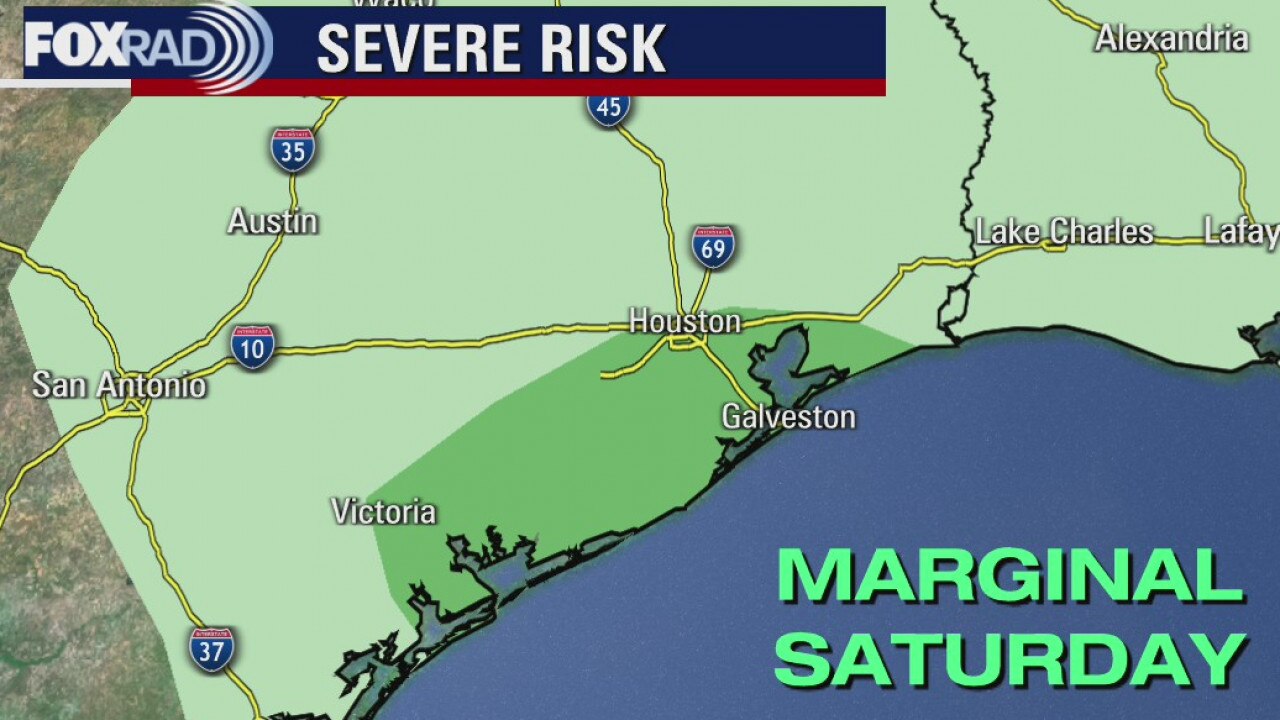
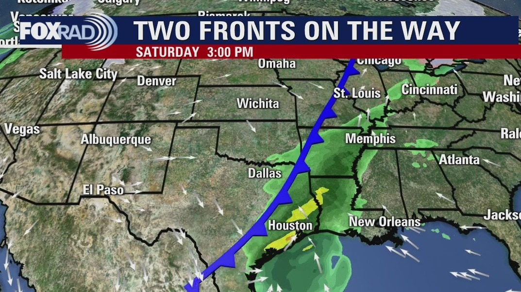
Showers and thunderstorms will be likely on Saturday as a cold front pushes through SE Texas and the Houston area. We could see a few strong storms as the front arrives. The next front gets here on Wednesday, which will cool us down just in time for Christmas Eve day.
Showers and thunderstorms will be likely on Saturday as a cold front pushes through SE Texas and the Houston area. We could see a few strong storms as the front arrives. The next front gets here on Wednesday, which will cool us down just in time for Christmas Eve day.
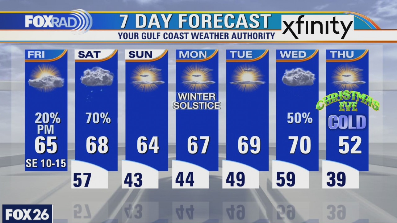
Friday weather forecast
After another chilly morning, changes are on the way as Gulf breezes return. Look for increasing clouds today along with a slight chance for drizzle. Light showers are possible overnight, then showers and storms are likely on Saturday as a front moves through. Sunday, Monday and Tuesday are looking great, but a big cold front is on the way Wednesday which should bring cold air for Christmas.
After another chilly morning, changes are on the way as Gulf breezes return. Look for increasing clouds today along with a slight chance for drizzle. Light showers are possible overnight, then showers and storms are likely on Saturday as a front moves through. Sunday, Monday and Tuesday are looking great, but a big cold front is on the way Wednesday which should bring cold air for Christmas.
Thursday Evening Weather Forecast
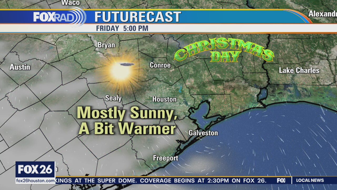
Here?s a look at Christmas Eve Day. A cold front will slide across Texas and the Houston area. We won?t have snow for Christmas, but it will be a little chilly and feel like good holiday weather.
Here?s a look at Christmas Eve Day. A cold front will slide across Texas and the Houston area. We won?t have snow for Christmas, but it will be a little chilly and feel like good holiday weather.

Thursday weather forecast
This morning?s low temperature of 31 was the second freeze of the season for Houston and should be the last for about a week. Two more cold fronts are on the way - one on Saturday and the next on Wednesday. Watch for showers late Friday and into Saturday. The front on Wednesday could bring very cold, windy conditions for Christmas Eve and a cold Christmas morning.
This morning?s low temperature of 31 was the second freeze of the season for Houston and should be the last for about a week. Two more cold fronts are on the way - one on Saturday and the next on Wednesday. Watch for showers late Friday and into Saturday. The front on Wednesday could bring very cold, windy conditions for Christmas Eve and a cold Christmas morning.