

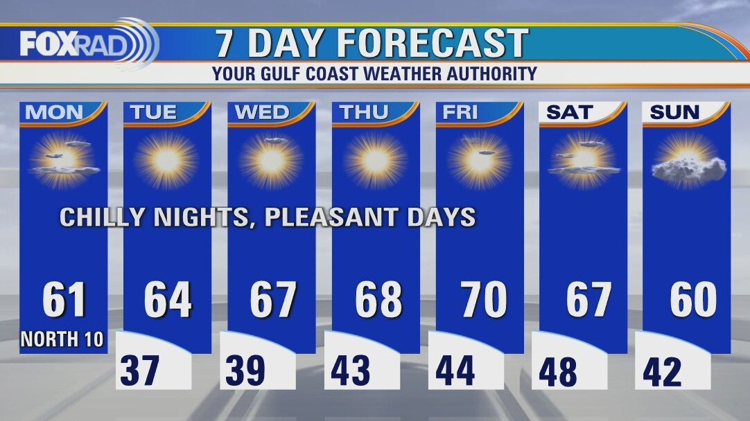
Monday weather forecast
After last week's freeze and threat for icing, this week looks very quiet. Each day will bring chilly nights with lows in the 30s and 40s with sunny and dry days. High temperatures will begin in the low 60s and gradually warm to around 70 by the end of the week.
After last week's freeze and threat for icing, this week looks very quiet. Each day will bring chilly nights with lows in the 30s and 40s with sunny and dry days. High temperatures will begin in the low 60s and gradually warm to around 70 by the end of the week.
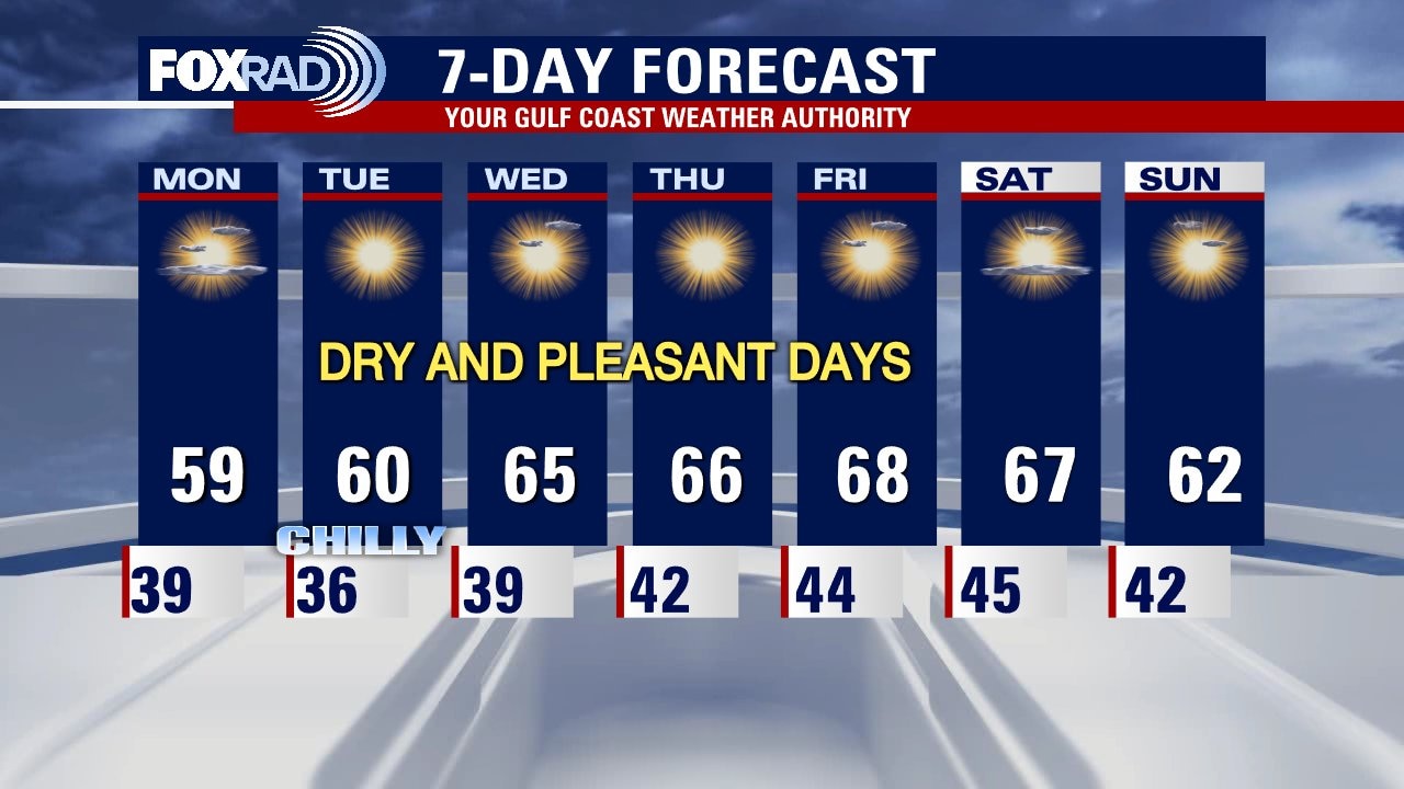
Sunday weather forecast with Meteorologist John Dawson
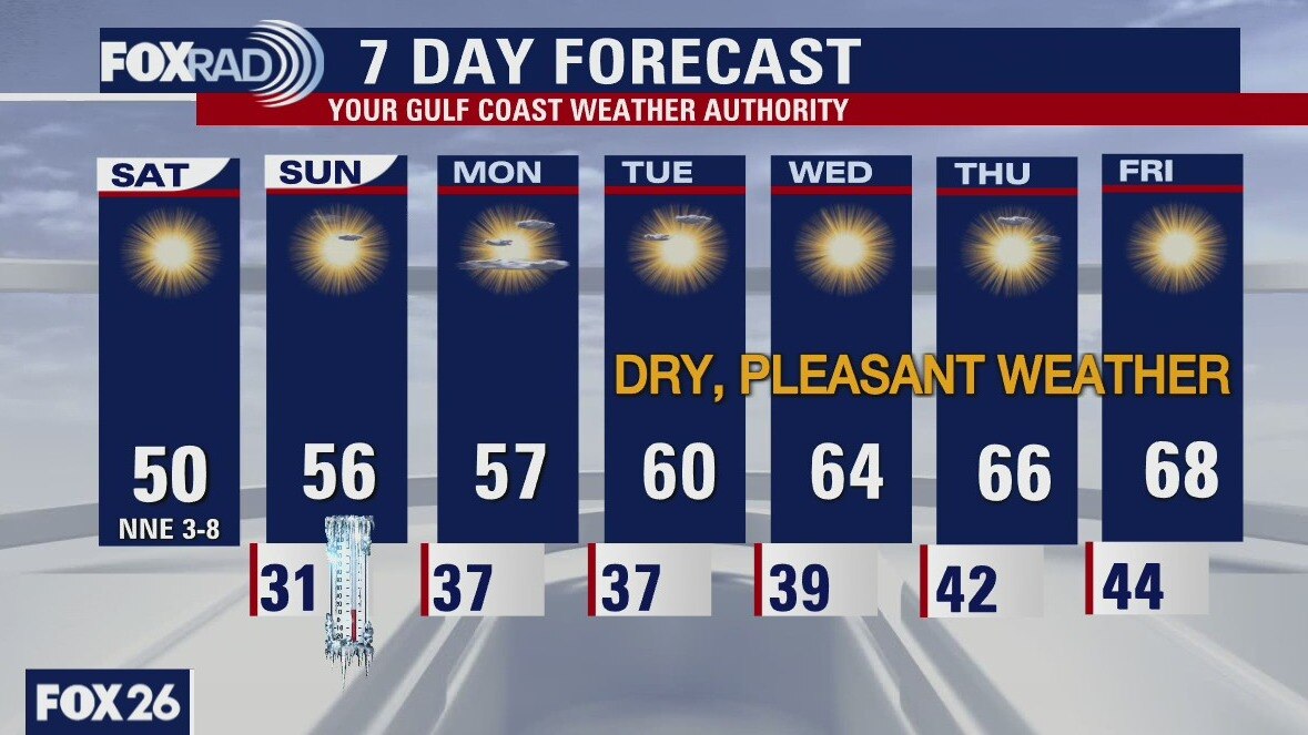
Houston is looking at a quiet and dry week. Mornings will start off chilly but lots of sunshine will make the afternoons pleasant. This would be a good week to wash the car. Enjoy some time outdoors!
Houston is looking at a quiet and dry week. Mornings will start off chilly but lots of sunshine will make the afternoons pleasant. This would be a good week to wash the car. Enjoy some time outdoors!
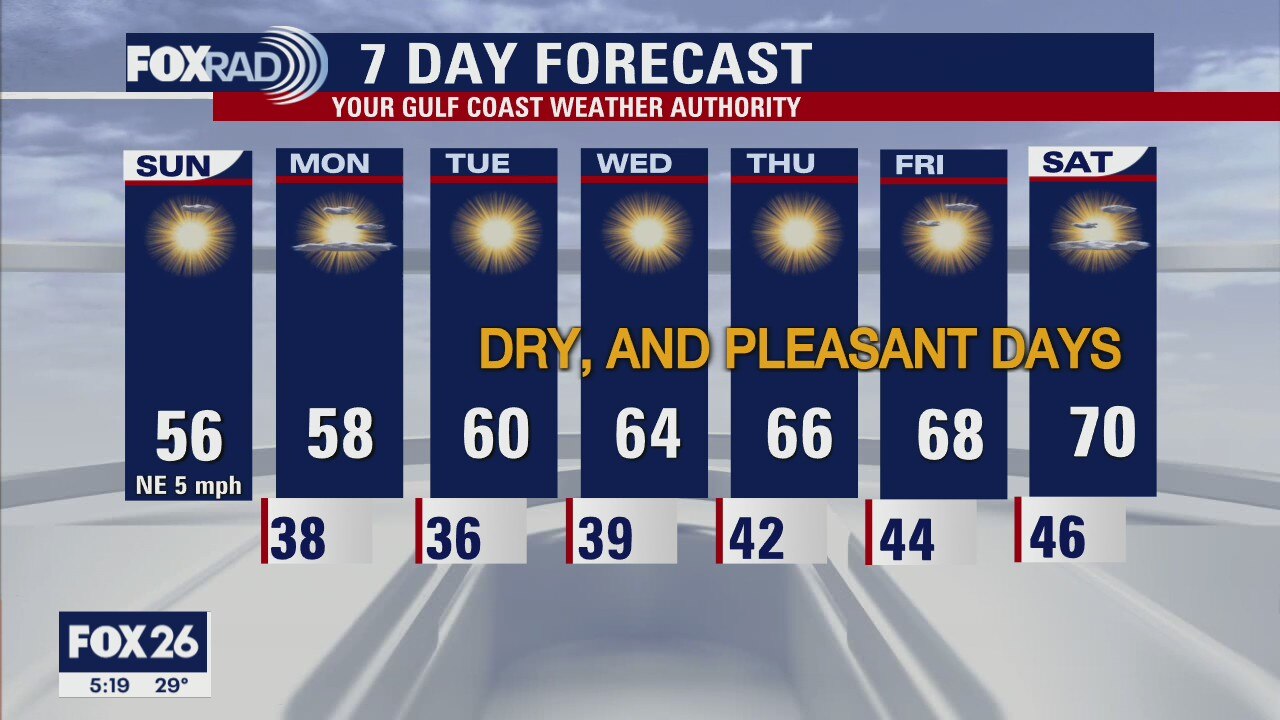
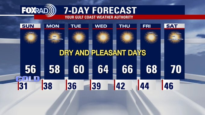
Your Sunday Morning Forecast with Meteorologist Lena Maria
Mother nature is paying us back for that cold snap! While mornings will still be chilly, we will be above freezing for the rest of the week. Temperatures will gradually rise by a few degrees each day, with abundant sunshine and high pressure in control. Highs should approach 70 by the weekend, which is great news for those with Valentine's Day or Super Bowl plans! As of right now, there is no rain in the 7 day forecast.
Mother nature is paying us back for that cold snap! While mornings will still be chilly, we will be above freezing for the rest of the week. Temperatures will gradually rise by a few degrees each day, with abundant sunshine and high pressure in control. Highs should approach 70 by the weekend, which is great news for those with Valentine's Day or Super Bowl plans! As of right now, there is no rain in the 7 day forecast.
Saturday weather forecast with Meteorologist John Dawson
It was great to have so much sunshine around Houston on Saturday. Look for more days ahead with lots of clear skies. The forecast also should be dry for the next week. Freezing temperatures for most of Southeast Texas on Sunday morning but not everyone.
It was great to have so much sunshine around Houston on Saturday. Look for more days ahead with lots of clear skies. The forecast also should be dry for the next week. Freezing temperatures for most of Southeast Texas on Sunday morning but not everyone.
Today's forecast and a look ahead at the coming week
Meteorologist Lena Maria Arango presents the forecast for today and the days ahead: After a cold and cloudy Friday, sunshine makes a return today. Mornings will still be cold this week, but only one more at or below freezing. Temperatures will slowly but surely climb their way back closer to seasonable by the end of next week. As of right now, high pressure reigns king so we don't have a drop of rain in the 7-day forecast!
Meteorologist Lena Maria Arango presents the forecast for today and the days ahead: After a cold and cloudy Friday, sunshine makes a return today. Mornings will still be cold this week, but only one more at or below freezing. Temperatures will slowly but surely climb their way back closer to seasonable by the end of next week. As of right now, high pressure reigns king so we don't have a drop of rain in the 7-day forecast!
Saturday morning weather forecast
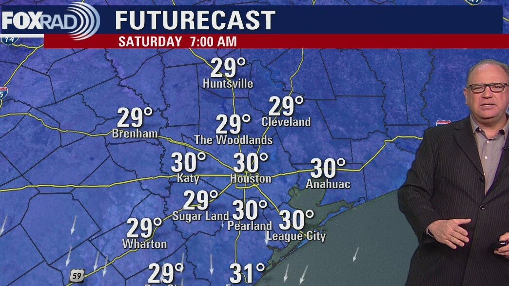
It will freeze again tonight and even a hard freeze NW of Houston. The sunshine will return and help warm things a little during the afternoons Saturday and Sunday. The coming week will bring more sunshine and slightly warmer temperatures.
It will freeze again tonight and even a hard freeze NW of Houston. The sunshine will return and help warm things a little during the afternoons Saturday and Sunday. The coming week will bring more sunshine and slightly warmer temperatures.

Friday evening weather forecast with Chief Meteorologist Dr. Jim Siebert
As expected, another Hard Freeze Warning is posted from 9 p.m. Friday until 10 a.m. Saturday for counties north and west of Houston. Temps will be near 20 degrees in these areas and precautions should be taken for pipes, plants, people, and pets. Houston is not included in this warning, but there will be a light freeze with temps above 25 degrees.
As expected, another Hard Freeze Warning is posted from 9 p.m. Friday until 10 a.m. Saturday for counties north and west of Houston. Temps will be near 20 degrees in these areas and precautions should be taken for pipes, plants, people, and pets. Houston is not included in this warning, but there will be a light freeze with temps above 25 degrees.
Friday afternoon weather forecast with Meteorologist Lena Maria Arango
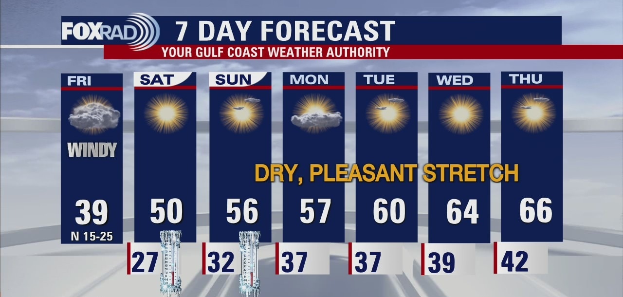
Highs today will only reach the upper 30s and low 40s, and you should expect another hard freeze tonight with lows in the mid-20s. The great news is that sunshine will return for the weekend along with much lighter winds and highs in the 50s.
Highs today will only reach the upper 30s and low 40s, and you should expect another hard freeze tonight with lows in the mid-20s. The great news is that sunshine will return for the weekend along with much lighter winds and highs in the 50s.

Harsh wind chills in Houston area on Friday
Winter weather advisory and wind chill advisory through noon today. Expect mostly cloudy skies, cold winds and highs in the upper 30s.
Winter weather advisory and wind chill advisory through noon today. Expect mostly cloudy skies, cold winds and highs in the upper 30s.


Texas Winter Storm: Freezing temperatures expected overnight, Friday morning
The Texas winter storm is bringing subfreezing temperatures, wintry precipitation, and more. Here's the latest on what's hitting the greater Houston area.
The Texas winter storm is bringing subfreezing temperatures, wintry precipitation, and more. Here's the latest on what's hitting the greater Houston area.

Friday Morning Weather Forecast
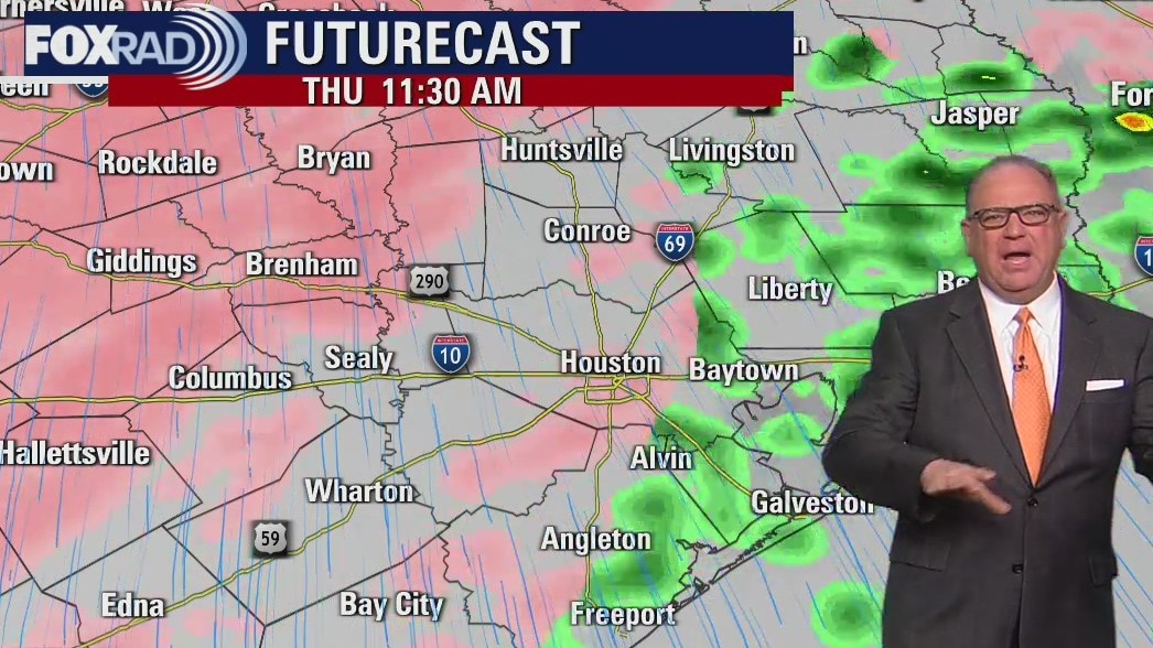
Roads will be slippery across SE Texas and Houston through midday on Friday. Road conditions will continue to worsen as the temperatures get colder tonight. Temps will be below freezing each night over the next three days and a hard freeze is posted for counties NW of Houston. Be very cautious when driving tonight.
Roads will be slippery across SE Texas and Houston through midday on Friday. Road conditions will continue to worsen as the temperatures get colder tonight. Temps will be below freezing each night over the next three days and a hard freeze is posted for counties NW of Houston. Be very cautious when driving tonight.

Thursday night freezing weather forecast with Chief Meteorologist Dr. Jim Siebert
Roads will be slippery across SE Texas and Houston through midday on Friday. Road conditions will continue to worsen as the temperatures get colder tonight. Temps will be below freezing each night over the next three days and a hard freeze is posted for counties NW of Houston. Be very cautious when driving tonight.
Roads will be slippery across SE Texas and Houston through midday on Friday. Road conditions will continue to worsen as the temperatures get colder tonight. Temps will be below freezing each night over the next three days and a hard freeze is posted for counties NW of Houston. Be very cautious when driving tonight.
Cold and windy Thursday in Southeast Texas
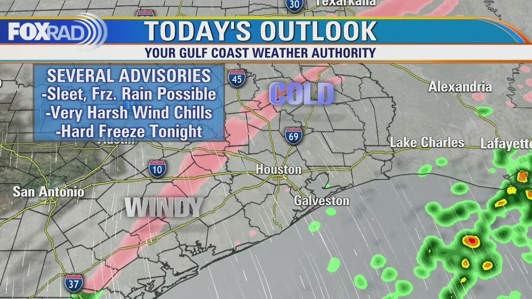
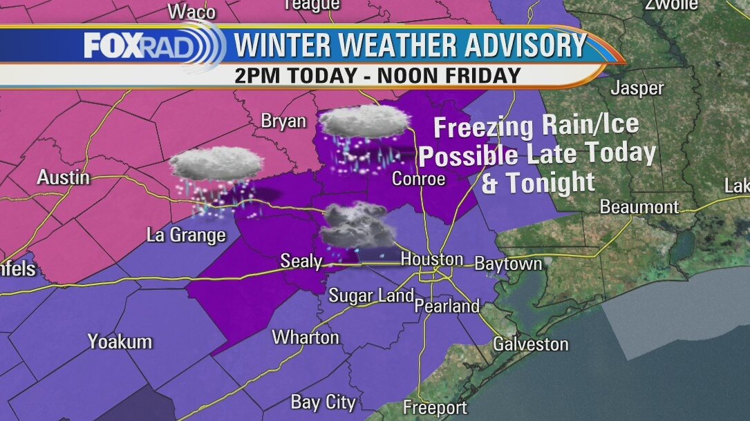
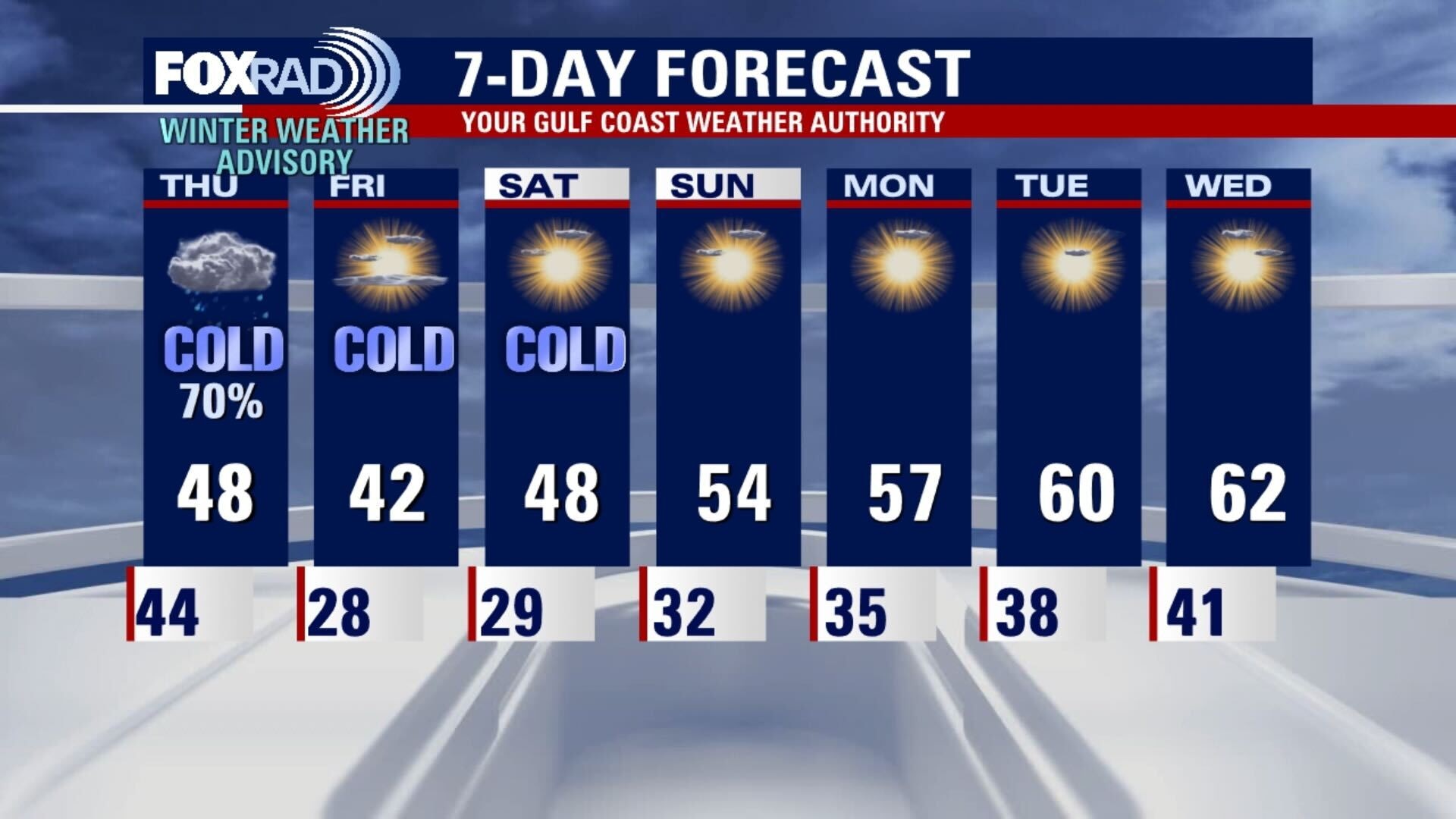
A winter weather advisory begins at 2 p.m. today with sleet and freezing rain possible. Rainy this morning, cold and windy with temperatures falling into the 30s all day. Expect wind chills in the teens and 20s.
A winter weather advisory begins at 2 p.m. today with sleet and freezing rain possible. Rainy this morning, cold and windy with temperatures falling into the 30s all day. Expect wind chills in the teens and 20s.
Cold and windy Thursday in Southeast Texas
A winter weather advisory begins at 2 p.m. today with sleet and freezing rain possible. Rainy this morning, cold and windy with temperatures falling into the 30s all day. Expect wind chills in the teens and 20s.
A winter weather advisory begins at 2 p.m. today with sleet and freezing rain possible. Rainy this morning, cold and windy with temperatures falling into the 30s all day. Expect wind chills in the teens and 20s.
Thursday morning weather forecast
A front arrives tonight, but the cold air moves in during the day Thursday. A Winter Weather Advisory runs from 2pm Thursday until 9 a.m. Friday. Freezing rain will be possible and roads will become slick and dangerous. Elevated roads and bridges will have icy issues all across SE Texas. Be safe out there.
A front arrives tonight, but the cold air moves in during the day Thursday. A Winter Weather Advisory runs from 2pm Thursday until 9 a.m. Friday. Freezing rain will be possible and roads will become slick and dangerous. Elevated roads and bridges will have icy issues all across SE Texas. Be safe out there.
Wednesday evening weather forecast with Chief Meteorologist Dr. Jim Siebert
A front arrives Wednesday night, but the cold air moves in during the day Thursday. A Winter Weather Advisory runs from 2 p.m. Thursday until 9 a.m. Friday. Freezing rain will be possible and roads will become slick and dangerous. Elevated roads and bridges will have icy issues all across SE Texas. Be safe out there.
A front arrives Wednesday night, but the cold air moves in during the day Thursday. A Winter Weather Advisory runs from 2 p.m. Thursday until 9 a.m. Friday. Freezing rain will be possible and roads will become slick and dangerous. Elevated roads and bridges will have icy issues all across SE Texas. Be safe out there.
Winter Storm: Looking at the next 4 days
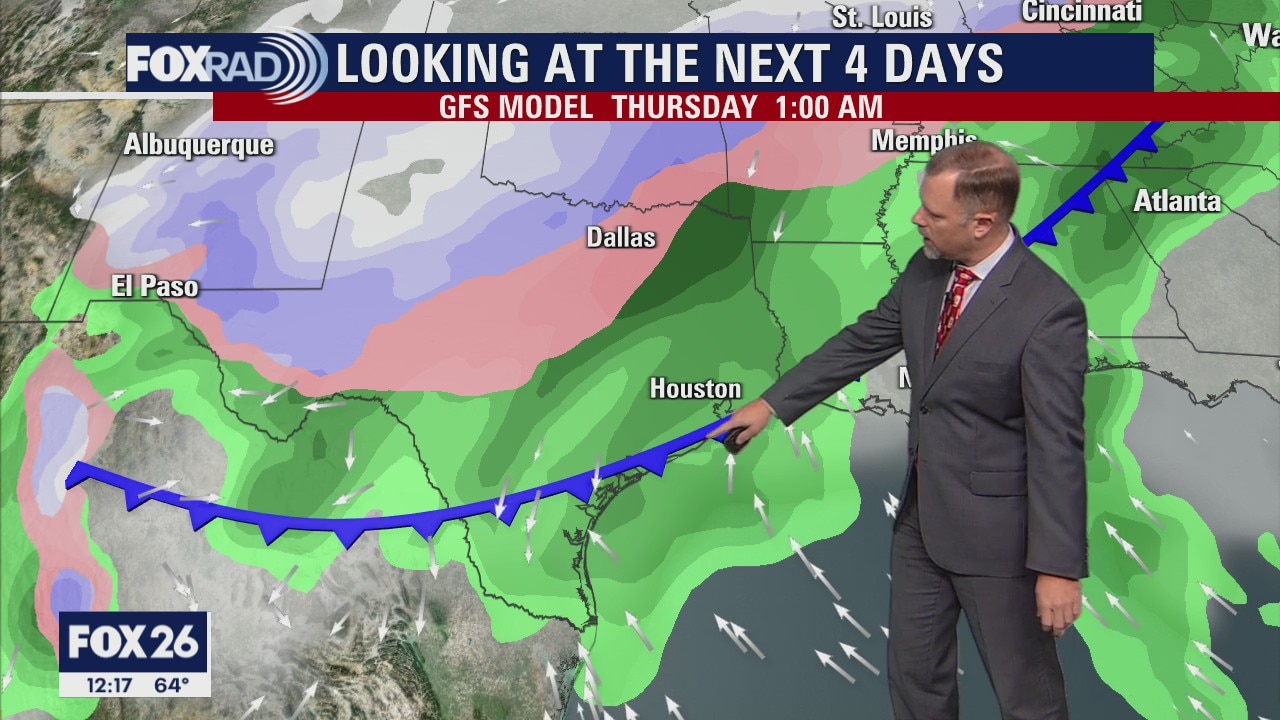
A winter storm is forecast to bring some of the coldest temperatures recorded in Texas since the deadly 2021 winter storm. There is a Winter Weather Advisory is in effect for most of Southeast Texas, including the City of Houston. Here's a look ahead at what we can expect.
A winter storm is forecast to bring some of the coldest temperatures recorded in Texas since the deadly 2021 winter storm. There is a Winter Weather Advisory is in effect for most of Southeast Texas, including the City of Houston. Here's a look ahead at what we can expect.
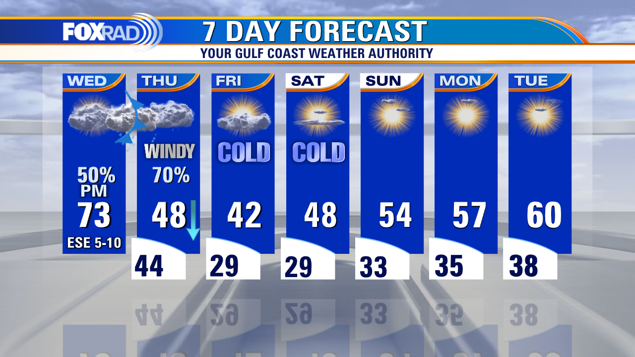
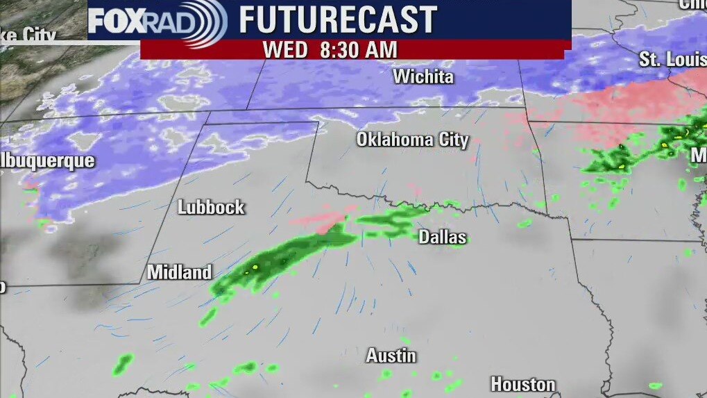
Wednesday weather forecast
A foggy start to Wednesday, which will be mostly cloudy and mild with showers and isolated thunderstorms rolling in later. The front brings a drastic drop in temperatures, and highs will only be in the 40s for the next few days. Overnight lows will be near or below freezing for a couple of nights too. Be sure to protect those 4 P's! The sun starts to reappear over the weekend and temperatures will gradually rise leading into next week.
A foggy start to Wednesday, which will be mostly cloudy and mild with showers and isolated thunderstorms rolling in later. The front brings a drastic drop in temperatures, and highs will only be in the 40s for the next few days. Overnight lows will be near or below freezing for a couple of nights too. Be sure to protect those 4 P's! The sun starts to reappear over the weekend and temperatures will gradually rise leading into next week.
Wednesday morning weather forecast
Temps will reach the 70s on Wed. until a strong front arrives in the evening. Rain will be likely into Thur. and there could be a wintry mix of sleet and maybe even some freezing rain north of Houston. It will be freezing for a few nights from Thurs night into the weekend.
Temps will reach the 70s on Wed. until a strong front arrives in the evening. Rain will be likely into Thur. and there could be a wintry mix of sleet and maybe even some freezing rain north of Houston. It will be freezing for a few nights from Thurs night into the weekend.
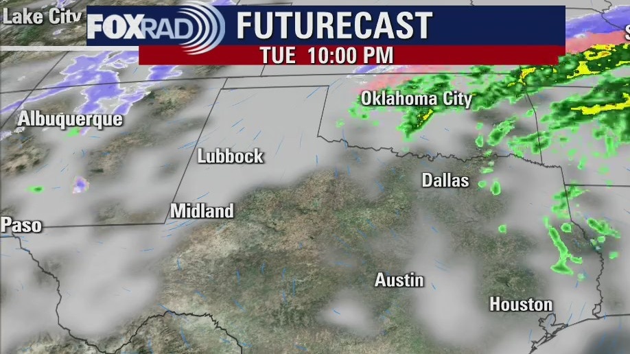
Tuesday evening weather forecast
Temps will reach the 70s on Wed. until a strong front arrives in the evening. Rain will be likely into Thur. and there could be a wintry mix of sleet and maybe even some freezing rain north of Houston. It will be freezing for a few nights from Thurs night into the weekend.
Temps will reach the 70s on Wed. until a strong front arrives in the evening. Rain will be likely into Thur. and there could be a wintry mix of sleet and maybe even some freezing rain north of Houston. It will be freezing for a few nights from Thurs night into the weekend.