

Sunday night leading into Memorial Day weather forecast
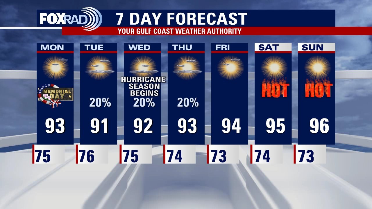
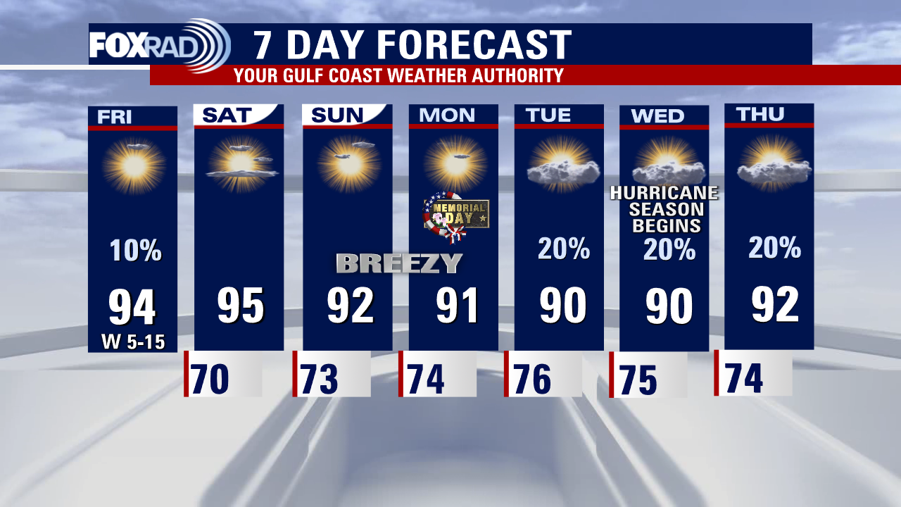
Memorial Day across Houston will see afternoon temps in the lower 90s but the feels-like temps will be over 100. Be safe if you are enjoying time outdoors. Isolated afternoon showers return to the forecast for Tue, Wed, and Thursday, and then look for a very hot and dry weekend.
Memorial Day across Houston will see afternoon temps in the lower 90s but the feels-like temps will be over 100. Be safe if you are enjoying time outdoors. Isolated afternoon showers return to the forecast for Tue, Wed, and Thursday, and then look for a very hot and dry weekend.
Sunday Morning Forecast with Meteorologist Lena Maria
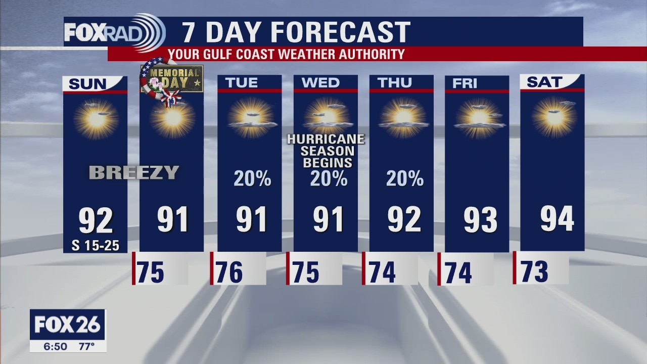
A warm, and breezy end to the long weekend with increasing humidity. Isolated to widely scattered daily showers and storms are possible, but will be very limited in coverage and intensity if they occur. Be sure to keep sun, heat, and swimming safety in mind for any outdoor plans as not much changes over the course of the extended period. Staying warm and sunny through our first weekend in June.
A warm, and breezy end to the long weekend with increasing humidity. Isolated to widely scattered daily showers and storms are possible, but will be very limited in coverage and intensity if they occur. Be sure to keep sun, heat, and swimming safety in mind for any outdoor plans as not much changes over the course of the extended period. Staying warm and sunny through our first weekend in June.
Saturday night leading into Sunday morning weather forecast
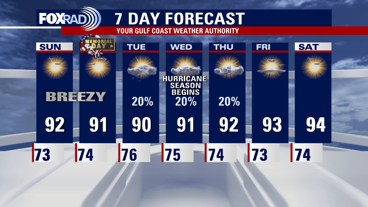
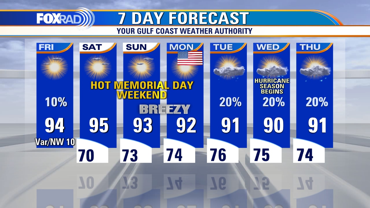
Plenty of sunshine and more heat is ahead for the rest of the holiday weekend. Highs will climb into the low 90s both tomorrow and Memorial Day with humidity levels increasing. If you are beach bound, breezy south winds could create rough surf and rip currents - so make sure you are checking in with the lifeguard before heading out into the water.
Plenty of sunshine and more heat is ahead for the rest of the holiday weekend. Highs will climb into the low 90s both tomorrow and Memorial Day with humidity levels increasing. If you are beach bound, breezy south winds could create rough surf and rip currents - so make sure you are checking in with the lifeguard before heading out into the water.
Saturday Morning Forecast with Meteorologist Lena Maria
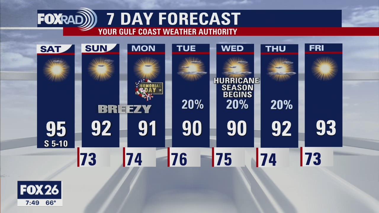
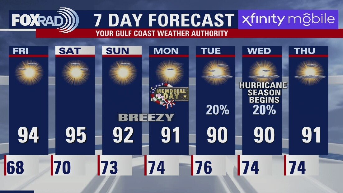
Another ozone action day today with bright sunshine and light winds. Today will also likely be the hottest day of the long weekend, with "feels like" values in the upper 90s. Although we don't need to worry about rain, be sure to practice sun/heat safety. Beach/swimming safety will be more of a concern Sunday and Monday, with stronger winds that could create rip currents, and choppy elevated seas. Not much changes in the extended forecast, though we may see some isolated showers middle of next week.
Another ozone action day today with bright sunshine and light winds. Today will also likely be the hottest day of the long weekend, with "feels like" values in the upper 90s. Although we don't need to worry about rain, be sure to practice sun/heat safety. Beach/swimming safety will be more of a concern Sunday and Monday, with stronger winds that could create rip currents, and choppy elevated seas. Not much changes in the extended forecast, though we may see some isolated showers middle of next week.
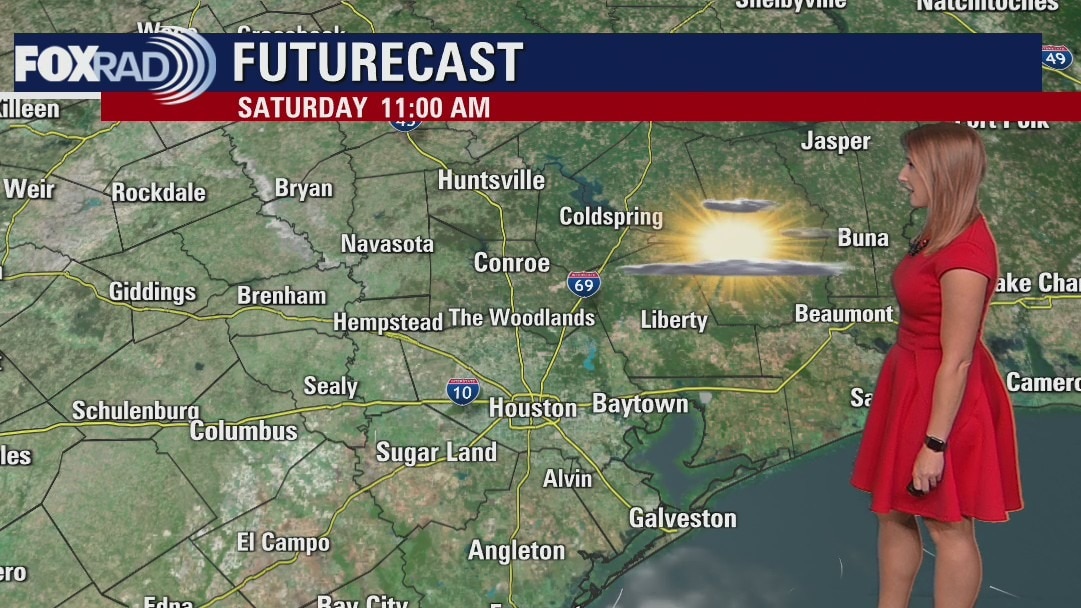
Saturday morning weather forecast
The unofficial start to Summer is here and Mother Nature is bringing the heat! Plenty of sunshine is expected all weekend long, with temperatures climbing into the 90s. Another Ozone Action Day is posted for tomorrow across Harris, Brazoria and Galveston counties. Not much changes in the forecast until the middle of next week, when we may welcome a few scattered showers across the region.
The unofficial start to Summer is here and Mother Nature is bringing the heat! Plenty of sunshine is expected all weekend long, with temperatures climbing into the 90s. Another Ozone Action Day is posted for tomorrow across Harris, Brazoria and Galveston counties. Not much changes in the forecast until the middle of next week, when we may welcome a few scattered showers across the region.

Friday evening weather forecast with Meteorologist Adrienne Vonn
The unofficial start to Summer is here and Mother Nature is bringing the heat! Plenty of sunshine is expected all weekend long, with temperatures climbing into the 90s. Another Ozone Action Day is posted for tomorrow across Harris, Brazoria, and Galveston counties. Not many changes in the forecast until the middle of next week, when we may welcome a few scattered showers across the region.
The unofficial start to Summer is here and Mother Nature is bringing the heat! Plenty of sunshine is expected all weekend long, with temperatures climbing into the 90s. Another Ozone Action Day is posted for tomorrow across Harris, Brazoria, and Galveston counties. Not many changes in the forecast until the middle of next week, when we may welcome a few scattered showers across the region.
Friday afternoon weather forecast with Meteorologist Lena Maria Arango
Heading into the long holiday weekend on a hot, and dry note. There is an Air Quality Alert for Ozone today for Harris, Brazoria, and Galveston counties. Unlike yesterday's clear blue skies, we'll see intervals of clouds and a sunny day with a very small risk for a pop-up shower or storm. Not many changes in the forecast until the middle of next week, when we may welcome back some rain chances. Enjoy the sunshine, stay hydrated, and don't forget that hurricane season begins next Wednesday, June 1st, our 30-minute Hurricane Season Special airs tonight at 9:30 p.m.
Heading into the long holiday weekend on a hot, and dry note. There is an Air Quality Alert for Ozone today for Harris, Brazoria, and Galveston counties. Unlike yesterday's clear blue skies, we'll see intervals of clouds and a sunny day with a very small risk for a pop-up shower or storm. Not many changes in the forecast until the middle of next week, when we may welcome back some rain chances. Enjoy the sunshine, stay hydrated, and don't forget that hurricane season begins next Wednesday, June 1st, our 30-minute Hurricane Season Special airs tonight at 9:30 p.m.
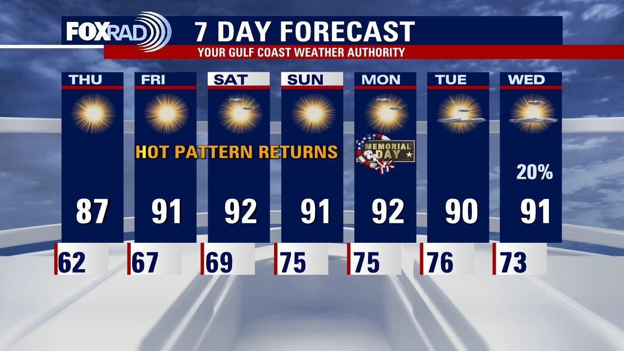
Hot Memorial Day weekend ahead
Sunny, hot weather is back and will remain in place through Memorial Day. Look for highs in the mid 90s today with a slight chance for an isolated late day storm. For the weekend, Sunday and Memorial Day Monday look a bit windy, so use caution if you plan to swim at the beach. Otherwise, protect yourself from the sun and try to stay cool. Next week, a few daily showers return beginning Tuesday.
Sunny, hot weather is back and will remain in place through Memorial Day. Look for highs in the mid 90s today with a slight chance for an isolated late day storm. For the weekend, Sunday and Memorial Day Monday look a bit windy, so use caution if you plan to swim at the beach. Otherwise, protect yourself from the sun and try to stay cool. Next week, a few daily showers return beginning Tuesday.
Friday morning weather forecast
High pressure dominates our weather pattern through at least the long weekend, keeping us sunny dry and quiet. Plan for lighter winds, lower humidity and a few more cool starts followed by warm, bright afternoons. As that high pressure shifts eastward toward the end of the weekend, we'll get a bit breezier with an approaching area of low pressure to the west. That brings the possibility for rain chances middle of next week, but for now they look fairly minimal.
High pressure dominates our weather pattern through at least the long weekend, keeping us sunny dry and quiet. Plan for lighter winds, lower humidity and a few more cool starts followed by warm, bright afternoons. As that high pressure shifts eastward toward the end of the weekend, we'll get a bit breezier with an approaching area of low pressure to the west. That brings the possibility for rain chances middle of next week, but for now they look fairly minimal.

Thursday evening weather forecast with Meteorologist Lena Maria Arango
High pressure dominates our weather pattern through at least the long weekend, keeping us sunny dry, and quiet. Plan for lighter winds, lower humidity, and a few more cool start followed by warm, bright afternoons. As that high pressure shifts eastward toward the end of the weekend, we'll get a bit breezier with an approaching area of low pressure to the west. That brings the possibility of rain chances middle of next week, but for now they look fairly minimal.
High pressure dominates our weather pattern through at least the long weekend, keeping us sunny dry, and quiet. Plan for lighter winds, lower humidity, and a few more cool start followed by warm, bright afternoons. As that high pressure shifts eastward toward the end of the weekend, we'll get a bit breezier with an approaching area of low pressure to the west. That brings the possibility of rain chances middle of next week, but for now they look fairly minimal.
Thursday morning weather forecast
We are entering another stretch of sunny, hot days with high temperatures running around 3-5 degrees above normal for the Memorial Day weekend. Patchy fog is possible over the next couple of nights, but otherwise, expect mostly clear conditions. Breezy south winds above 20 mph are possible for Sunday and Monday. The outlook for the first week of June looks slightly warmer than normal with highs in the low 90s.
We are entering another stretch of sunny, hot days with high temperatures running around 3-5 degrees above normal for the Memorial Day weekend. Patchy fog is possible over the next couple of nights, but otherwise, expect mostly clear conditions. Breezy south winds above 20 mph are possible for Sunday and Monday. The outlook for the first week of June looks slightly warmer than normal with highs in the low 90s.
Thursday morning weather forecast
Thursday looks like a fantastic end of May day across Houston. Look for dry air with a mild start and warm afternoon highs. As we head into the holiday weekend, we start another stretch of hot days with very little chances for rain. So that means we do look to stay dry through Memorial day, with rain chances possibly returning middle of next week.
Thursday looks like a fantastic end of May day across Houston. Look for dry air with a mild start and warm afternoon highs. As we head into the holiday weekend, we start another stretch of hot days with very little chances for rain. So that means we do look to stay dry through Memorial day, with rain chances possibly returning middle of next week.
Wednesday evening weather forecast with Meteorologist John Dawson
Thursday looks like a fantastic end of May day across Houston. Look for dry air with a mild start and warm afternoon highs. As we head into the holiday weekend, we start another stretch of hot days with very few chances for rain. So that means we do look to stay dry through Memorial day, with rain chances possibly returning middle of next week.
Thursday looks like a fantastic end of May day across Houston. Look for dry air with a mild start and warm afternoon highs. As we head into the holiday weekend, we start another stretch of hot days with very few chances for rain. So that means we do look to stay dry through Memorial day, with rain chances possibly returning middle of next week.

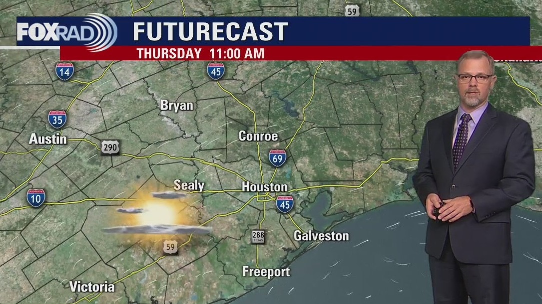
Brief cool-down Wednesday, with chance for late day storms
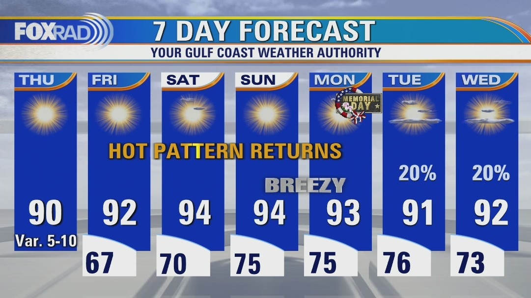
A line of severe storms blew through the Houston area between 2 a.m. and 5 a.m. this morning and, in the wake of those storms, we will enjoy a brief cool-down and a chance for a few late day storms today. Thursday will begin with morning temps in the 50s and low 60s followed by highs in the upper 80s. A heatwave returns for Friday and the Memorial Day weekend with highs in the low to mid-90s and lots of strong sunshine.
A line of severe storms blew through the Houston area between 2 a.m. and 5 a.m. this morning and, in the wake of those storms, we will enjoy a brief cool-down and a chance for a few late day storms today. Thursday will begin with morning temps in the 50s and low 60s followed by highs in the upper 80s. A heatwave returns for Friday and the Memorial Day weekend with highs in the low to mid-90s and lots of strong sunshine.
Wednesday Early Morning Forecast
Southeast Texas will see another round of storms Tuesday night as a cold front moves through. Houston should prepare for strong winds and heavy rain. The area will start to dry out on Thursday and another long stretch of warm/dry weather starts with the holiday weekend.
Southeast Texas will see another round of storms Tuesday night as a cold front moves through. Houston should prepare for strong winds and heavy rain. The area will start to dry out on Thursday and another long stretch of warm/dry weather starts with the holiday weekend.
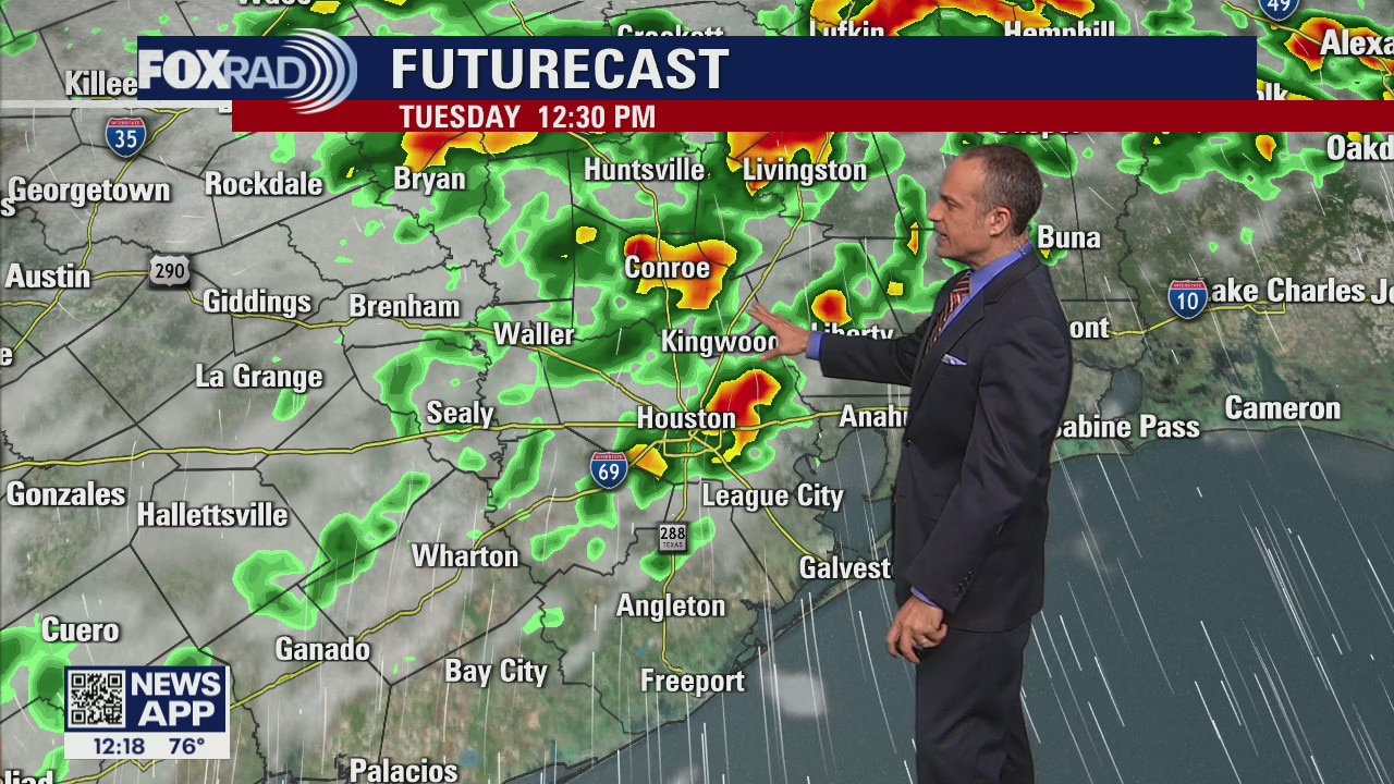
More storms in the forecast
FOX 26 Meteorologist Mike Iscovitz takes a look at the forecast for Tuesday and more storms expected Wednesday morning.
FOX 26 Meteorologist Mike Iscovitz takes a look at the forecast for Tuesday and more storms expected Wednesday morning.
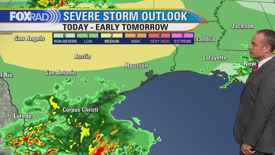
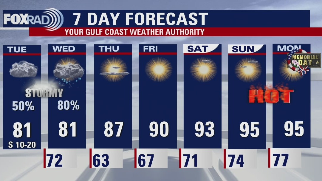
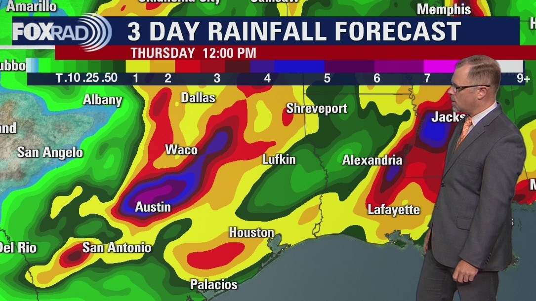
Scattered showers and storms possible on Tuesday
Storm coverage is likely to be lower than previously expected today, but scattered storms are still possible, especially south of I-10 this morning and east of I-45 this afternoon. Highs should rise to the mid 80s. One or two waves of rain are likely on Wednesday and the National Weather Service still has our area under an isolated to scattered chance for severe weather. Rain totals still could reach 3" in spots.
Storm coverage is likely to be lower than previously expected today, but scattered storms are still possible, especially south of I-10 this morning and east of I-45 this afternoon. Highs should rise to the mid 80s. One or two waves of rain are likely on Wednesday and the National Weather Service still has our area under an isolated to scattered chance for severe weather. Rain totals still could reach 3" in spots.
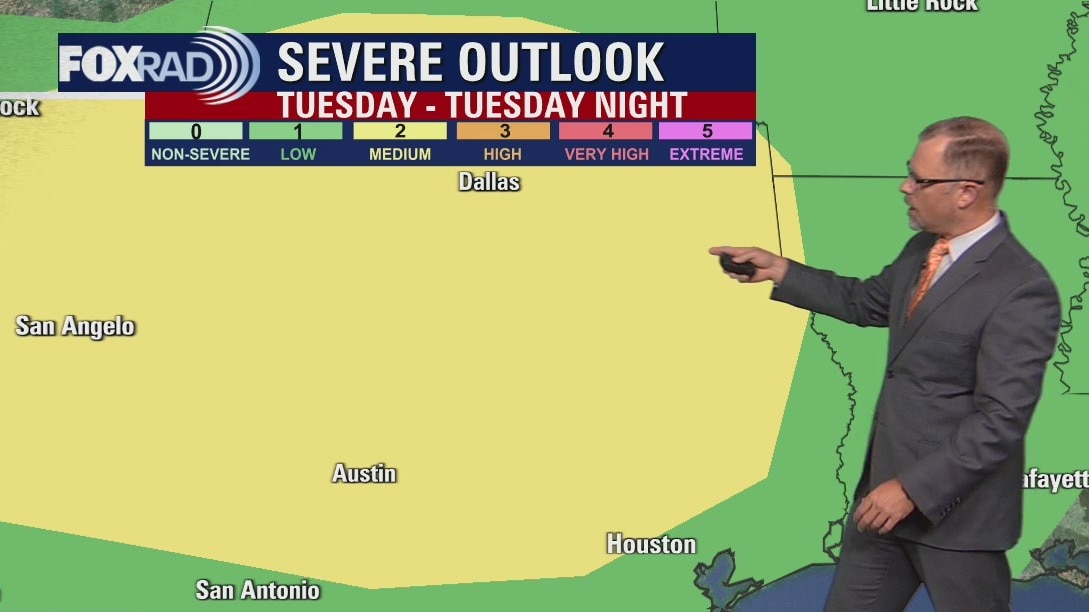
Stormy weather and showers on the way
Monday was quiet across Houston but stormy weather returns to Southeast Texas on Tuesday morning. Several rounds of showers and storms will move across the area until a front late Wednesday slowly clears the skies. A warm and dry pattern returns for the end of the week and runs through the holiday weekend.
Monday was quiet across Houston but stormy weather returns to Southeast Texas on Tuesday morning. Several rounds of showers and storms will move across the area until a front late Wednesday slowly clears the skies. A warm and dry pattern returns for the end of the week and runs through the holiday weekend.
Stormy weather returns on Tuesday morning
Monday was quiet across Houston but stormy weather returns to Southeast Texas on Tuesday morning. Several rounds of showers and storms will move across the area until a front late Wednesday slowly clears the skies. A warm and dry pattern returns for the end of the week and runs through the holiday weekend.
Monday was quiet across Houston but stormy weather returns to Southeast Texas on Tuesday morning. Several rounds of showers and storms will move across the area until a front late Wednesday slowly clears the skies. A warm and dry pattern returns for the end of the week and runs through the holiday weekend.
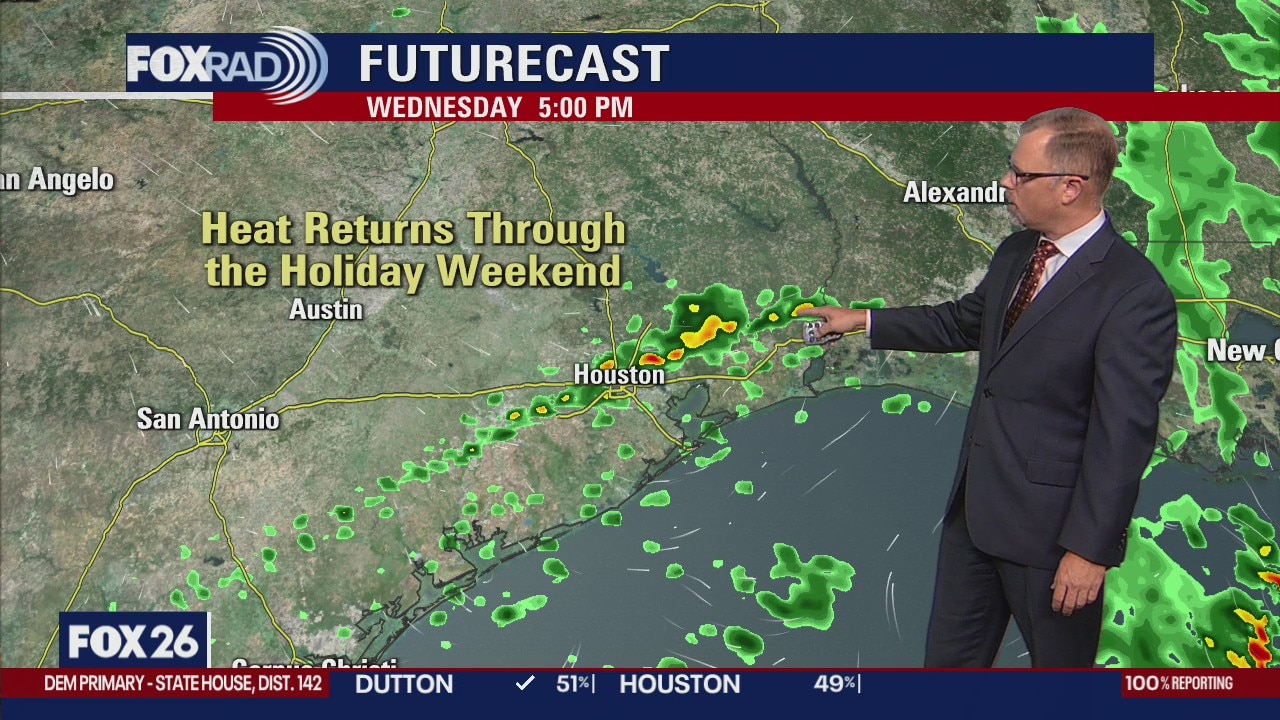
More storms ahead this week
A line of storms Saturday night brought drought relief, but also some of the coolest temperatures since late April. We should see at least one more complex of strong storms Tuesday, then the potential for a last round on Wednesday. This rain is much needed as areas south of Houston are now in a severe to extreme drought. Following the final round of rain late Wednesday, more hot, humid air will build in through this weekend with highs back in the mid-90s.
A line of storms Saturday night brought drought relief, but also some of the coolest temperatures since late April. We should see at least one more complex of strong storms Tuesday, then the potential for a last round on Wednesday. This rain is much needed as areas south of Houston are now in a severe to extreme drought. Following the final round of rain late Wednesday, more hot, humid air will build in through this weekend with highs back in the mid-90s.