

Saturday night leading into Sunday morning weather forecast
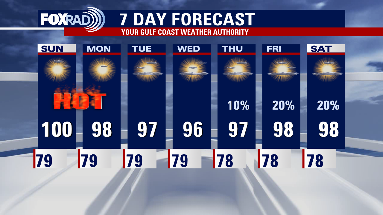
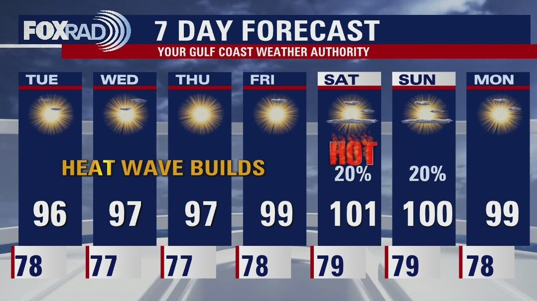
Another scorching hot day is on deck tomorrow. Heat advisories have been extended through 8 p.m. Sunday. High temperatures will be approaching record territory and heat index values up to 111 are possible. Gulf breezes will begin to kick up early next week, dropping temperatures slightly.
Another scorching hot day is on deck tomorrow. Heat advisories have been extended through 8 p.m. Sunday. High temperatures will be approaching record territory and heat index values up to 111 are possible. Gulf breezes will begin to kick up early next week, dropping temperatures slightly.
Saturday Morning Forecast with Meteorologist Lena Maria Arango
Dangerous heat has prompted a Heat Advisory area wide today from 11am-8pm for feels like values up to 108 degrees. That will likely extend into the day tomorrow, with a very similar forecast for Sunday. Gulf breezes kick up a bit at the start of next week, bumping temperatures down ever so slightly. If we're lucky, we may squeeze out some showers at least by the tail end of next week.
Dangerous heat has prompted a Heat Advisory area wide today from 11am-8pm for feels like values up to 108 degrees. That will likely extend into the day tomorrow, with a very similar forecast for Sunday. Gulf breezes kick up a bit at the start of next week, bumping temperatures down ever so slightly. If we're lucky, we may squeeze out some showers at least by the tail end of next week.
Saturday morning weather forecast
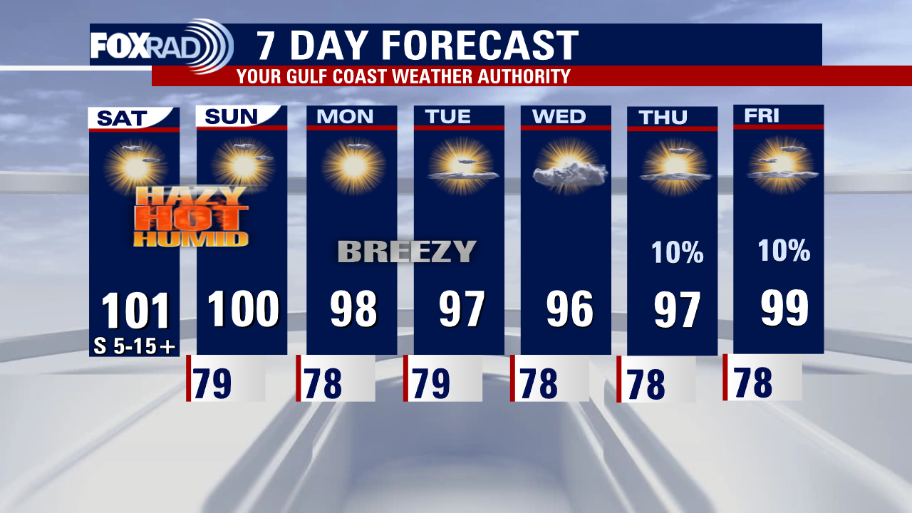
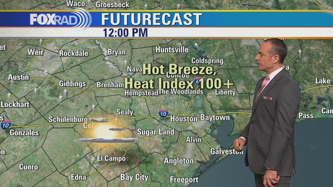
A dangerously hot weekend is setting up across Southeast Texas. Highs both Saturday and Sunday will hover near 100 with feels like values soaring between 105-110. Heat advisories have been issued area wide for Saturday from 11am - 8pm. Limit your outdoor time during the hottest part of the day and make sure you are drinking plenty of water.
A dangerously hot weekend is setting up across Southeast Texas. Highs both Saturday and Sunday will hover near 100 with feels like values soaring between 105-110. Heat advisories have been issued area wide for Saturday from 11am - 8pm. Limit your outdoor time during the hottest part of the day and make sure you are drinking plenty of water.
Friday afternoon weather forecast with Meteorologist Lena Maria Arango
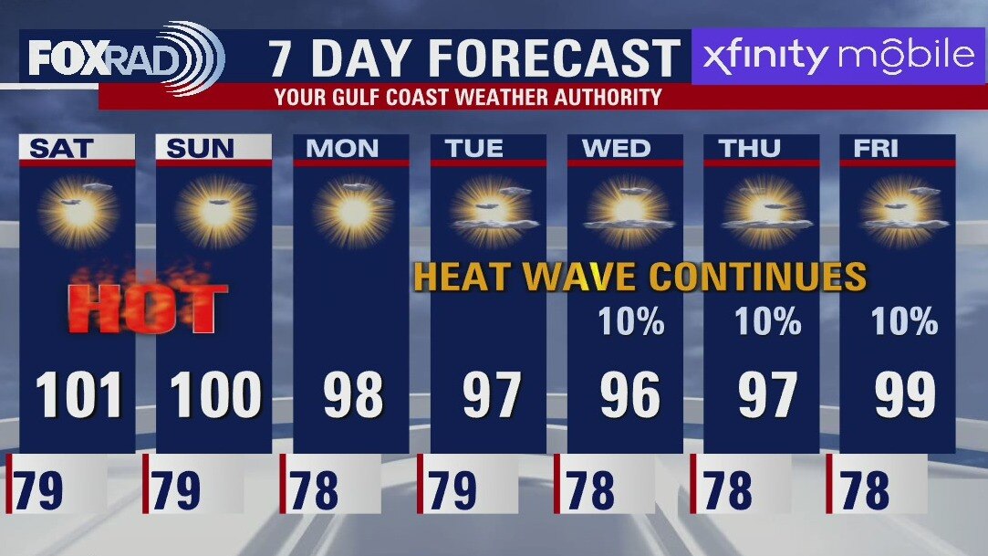
A dangerous pattern is settling in for the weekend, with Heat Advisories likely on Saturday and Sunday. While actual temperatures will hover near 100, feels like values will surge closer to 108 degrees. UV indices will also be extreme. Light winds won't offer much relief, but breezes pick up at the start of next week and that will help lower temperatures somewhat. We may see some lighter passing showers or storms by midweek, with better rain chances moving in for next weekend.
A dangerous pattern is settling in for the weekend, with Heat Advisories likely on Saturday and Sunday. While actual temperatures will hover near 100, feels like values will surge closer to 108 degrees. UV indices will also be extreme. Light winds won't offer much relief, but breezes pick up at the start of next week and that will help lower temperatures somewhat. We may see some lighter passing showers or storms by midweek, with better rain chances moving in for next weekend.
Hot Friday and weekend ahead
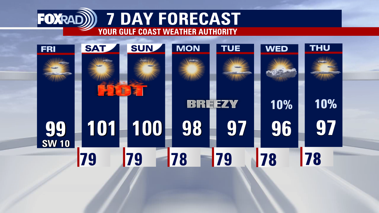
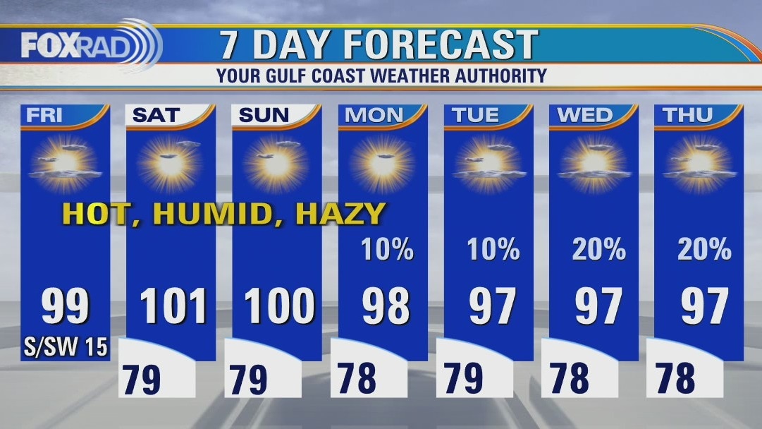
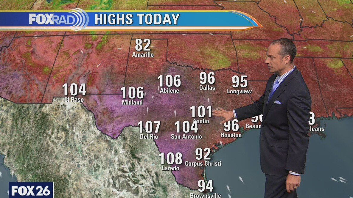
Brace yourself for more record or near record heat today and this weekend along with hazy skies from some Saharan dust. Highs will top out near 100 inlands and in the low to mid 90s near the coastline through at least Monday. Storms in the region will most likely just miss us to our east, so little to no help from rainfall. Air quality this weekend could potentially be affected by dust, also known as particulate matter. Otherwise, protect yourself from intense sunshine and heat index values briefly above 105.
Brace yourself for more record or near record heat today and this weekend along with hazy skies from some Saharan dust. Highs will top out near 100 inlands and in the low to mid 90s near the coastline through at least Monday. Storms in the region will most likely just miss us to our east, so little to no help from rainfall. Air quality this weekend could potentially be affected by dust, also known as particulate matter. Otherwise, protect yourself from intense sunshine and heat index values briefly above 105.
Friday morning weather forecast
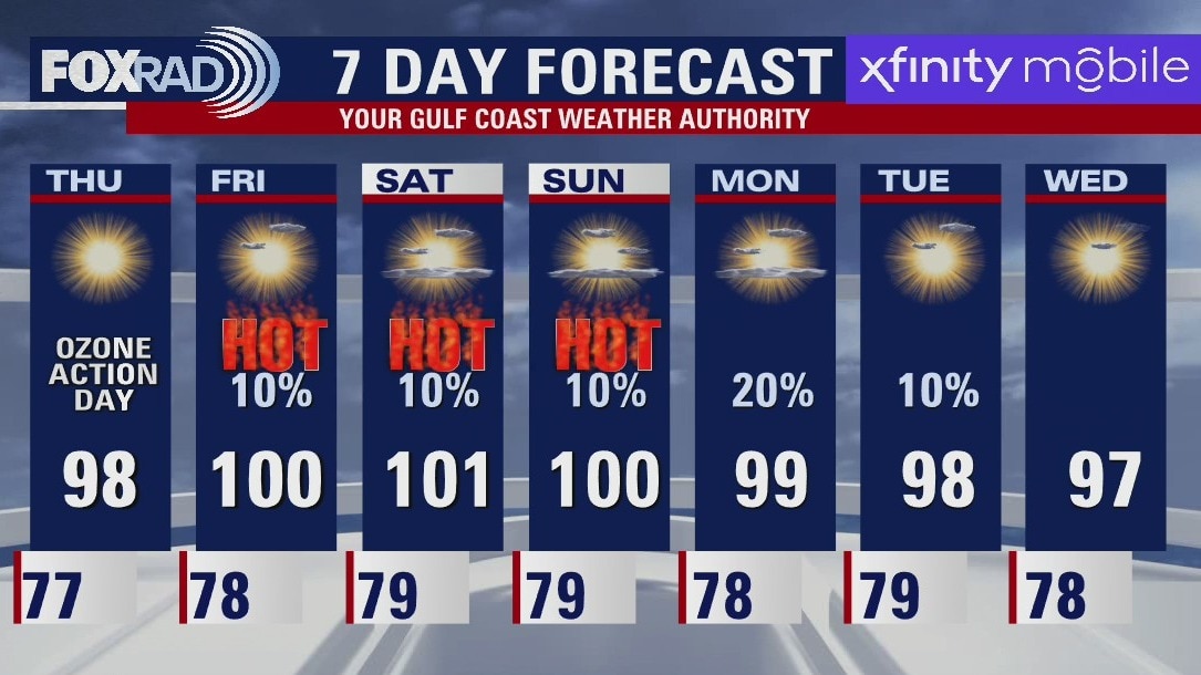
Houston will likely see heat advisories as we move into the weekend. Southeast Texas will see triple digit feels like values from Friday through Sunday. Plan to take breaks if you are outdoors and stay hydrated! Rain chances are not "zero" but they are very slim for the extended period, with only very isolated showers. That pattern remains in place as we move into next week.
Houston will likely see heat advisories as we move into the weekend. Southeast Texas will see triple digit feels like values from Friday through Sunday. Plan to take breaks if you are outdoors and stay hydrated! Rain chances are not "zero" but they are very slim for the extended period, with only very isolated showers. That pattern remains in place as we move into next week.
Thursday evening weather forecast with Meteorologist John Dawson
Houston will likely see heat advisories as we move into the weekend. Southeast Texas will see triple-digit feels like values from Friday through Sunday. Plan to take breaks if you are outdoors and stay hydrated! Rain chances are not "zero" but they are very slim for the extended period, with only very isolated showers. That pattern remains in place as we move into next week.
Houston will likely see heat advisories as we move into the weekend. Southeast Texas will see triple-digit feels like values from Friday through Sunday. Plan to take breaks if you are outdoors and stay hydrated! Rain chances are not "zero" but they are very slim for the extended period, with only very isolated showers. That pattern remains in place as we move into next week.

Extreme heat taking over southeast Texas
A very hot weekend is on the way in southeast Texas, we will likely see a heat advisory for triple-digit feels-like values from Friday through Sunday. Take it easy out there, especially during peak heating of the day. Rain chances remain fairly non-existent for the extended period, with only very isolated showers at best. Not much changes heading into next week, aside from a slight decrease in temperatures and an increase in gulf breezes as this building area of high pressure slides off to our east.
A very hot weekend is on the way in southeast Texas, we will likely see a heat advisory for triple-digit feels-like values from Friday through Sunday. Take it easy out there, especially during peak heating of the day. Rain chances remain fairly non-existent for the extended period, with only very isolated showers at best. Not much changes heading into next week, aside from a slight decrease in temperatures and an increase in gulf breezes as this building area of high pressure slides off to our east.

Baking in the sun for another week
This is a rinse and repeat kind of forecast with only subtle changes day to day. The only chance for rain over the next several days would be if an unusually strong line of storms, which will be frequent from Oklahoma to Mississippi, were to just clip our northeast counties. Other than that, we're baking in the sun for the next week or longer.
This is a rinse and repeat kind of forecast with only subtle changes day to day. The only chance for rain over the next several days would be if an unusually strong line of storms, which will be frequent from Oklahoma to Mississippi, were to just clip our northeast counties. Other than that, we're baking in the sun for the next week or longer.
Thursday morning weather forecast
The much discussed heat wave is settling into Southeast Texas. Look for record high temperature possible the next couple of days. It is also likely the National Weather Service will need to issue Heat Advisories as well. And we can also add an Ozone Action Day into the forecast for Thursday. Be safe in the heat!
The much discussed heat wave is settling into Southeast Texas. Look for record high temperature possible the next couple of days. It is also likely the National Weather Service will need to issue Heat Advisories as well. And we can also add an Ozone Action Day into the forecast for Thursday. Be safe in the heat!

Wednesday evening weather forecast with Meteorologist John Dawson
The much-discussed heat wave is settling into Southeast Texas. Look for record high temperatures possible in the next couple of days. It is also likely the National Weather Service will need to issue Heat Advisories as well. And we can also add an Ozone Action Day into the forecast for Thursday. Be safe in the heat!
The much-discussed heat wave is settling into Southeast Texas. Look for record high temperatures possible in the next couple of days. It is also likely the National Weather Service will need to issue Heat Advisories as well. And we can also add an Ozone Action Day into the forecast for Thursday. Be safe in the heat!
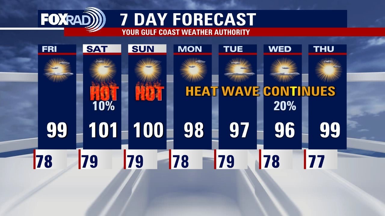
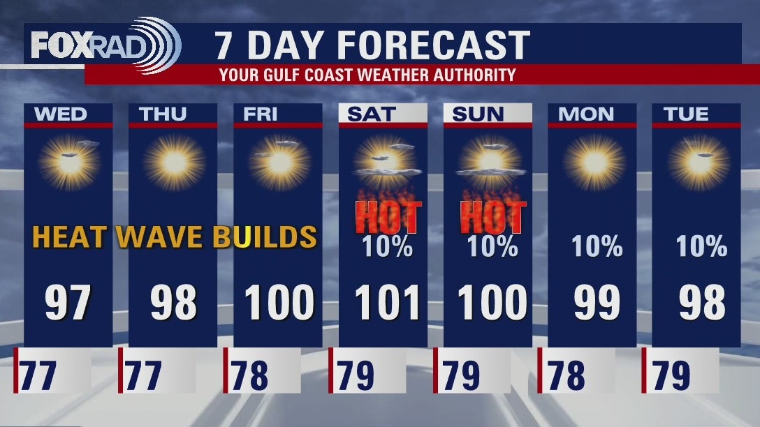
Strong heat wave feels hot, hot, hot!
A strong, early-season heat wave will continue across most of Texas for the next week or two and we could feel some of the hottest weather since last summer, and in some locations possibly the hottest since 2020. Look for highs ranging from the mid-90s to 100�, with only a very slight chance for storms well to the northeast of Houston.
A strong, early-season heat wave will continue across most of Texas for the next week or two and we could feel some of the hottest weather since last summer, and in some locations possibly the hottest since 2020. Look for highs ranging from the mid-90s to 100�, with only a very slight chance for storms well to the northeast of Houston.
Wednesday morning weather forecast
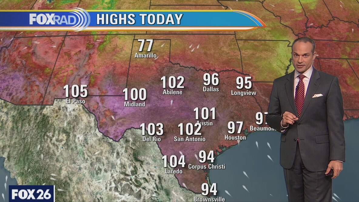
A strong heat wave is taking over the weather for Southeast Texas and will likely persist for a week or more. Upper level high pressure should help to push our temperatures from the mid 90s to the upper 90s as we move through the rest of the week. Expect some triple-digits when the weekend rolls around. Rain chances are not "zero" but they are very slim. It is still early in the summer for this kind of heat and our bodies are still adjusting. Be safe when working or playing outdoors.
A strong heat wave is taking over the weather for Southeast Texas and will likely persist for a week or more. Upper level high pressure should help to push our temperatures from the mid 90s to the upper 90s as we move through the rest of the week. Expect some triple-digits when the weekend rolls around. Rain chances are not "zero" but they are very slim. It is still early in the summer for this kind of heat and our bodies are still adjusting. Be safe when working or playing outdoors.
Tuesday evening weather forecast
A strong heat wave is taking over the weather for Southeast Texas and will likely persist for a week or more. Upper level high pressure should help to push our temperatures from the mid 90s to the upper 90s as we move through the rest of the week. Expect some triple-digits when the weekend rolls around. Rain chances are not "zero" but they are very slim. It is still early in the summer for this kind of heat and our bodies are still adjusting. Be safe when working or playing outdoors.
A strong heat wave is taking over the weather for Southeast Texas and will likely persist for a week or more. Upper level high pressure should help to push our temperatures from the mid 90s to the upper 90s as we move through the rest of the week. Expect some triple-digits when the weekend rolls around. Rain chances are not "zero" but they are very slim. It is still early in the summer for this kind of heat and our bodies are still adjusting. Be safe when working or playing outdoors.
Heat wave here for days...
A heat wave is in place and will likely persist for at least a week and possibly longer. High pressure should drive our temperatures from the mid-90s today to the upper 90s and some triple-digits by this weekend. Temperatures in central and southwest Texas could exceed 105 all week long. Rain chances remain slim - not zero, but also not very likely. The tropics remain quiet for now.
A heat wave is in place and will likely persist for at least a week and possibly longer. High pressure should drive our temperatures from the mid-90s today to the upper 90s and some triple-digits by this weekend. Temperatures in central and southwest Texas could exceed 105 all week long. Rain chances remain slim - not zero, but also not very likely. The tropics remain quiet for now.
Tuesday morning weather forecast
Another heat wave returns to Southeast Texas! And this one will be stronger than the last. A large area of high pressure will build in over West Texas bringing several days of sizzling weather from Phoenix to El Paso to Houston. Highs in central Texas and in parts of the Rio Grande Valley will experience highs ranging from 105? to 110?, while the Gulf Coast should stay in the upper 90s or slightly above 100 by this weekend. Use care to stay hydrated if you are outdoors. Houston is just under the criteria for Heat Advisories right now, but that will change as we move through the week.
Another heat wave returns to Southeast Texas! And this one will be stronger than the last. A large area of high pressure will build in over West Texas bringing several days of sizzling weather from Phoenix to El Paso to Houston. Highs in central Texas and in parts of the Rio Grande Valley will experience highs ranging from 105? to 110?, while the Gulf Coast should stay in the upper 90s or slightly above 100 by this weekend. Use care to stay hydrated if you are outdoors. Houston is just under the criteria for Heat Advisories right now, but that will change as we move through the week.
Monday evening weather forecast
Another heat wave returns to Southeast Texas! And this one will be stronger than the last. A large area of high pressure will build in over West Texas bringing several days of sizzling weather from Phoenix to El Paso to Houston. Highs in central Texas and in parts of the Rio Grande Valley will experience highs ranging from 105 to 110 degrees, while the Gulf Coast should stay in the upper 90s or slightly above 100 by this weekend. Use care to stay hydrated if you are outdoors. Houston is just under the criteria for Heat Advisories right now, but that will change as we move through the week.
Another heat wave returns to Southeast Texas! And this one will be stronger than the last. A large area of high pressure will build in over West Texas bringing several days of sizzling weather from Phoenix to El Paso to Houston. Highs in central Texas and in parts of the Rio Grande Valley will experience highs ranging from 105 to 110 degrees, while the Gulf Coast should stay in the upper 90s or slightly above 100 by this weekend. Use care to stay hydrated if you are outdoors. Houston is just under the criteria for Heat Advisories right now, but that will change as we move through the week.
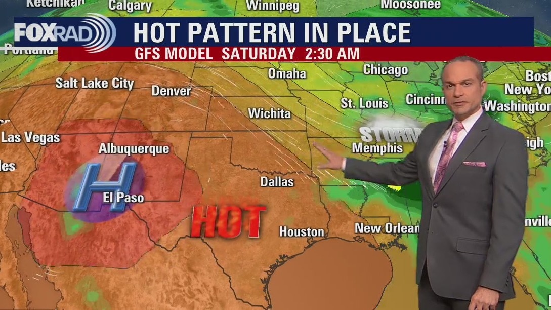
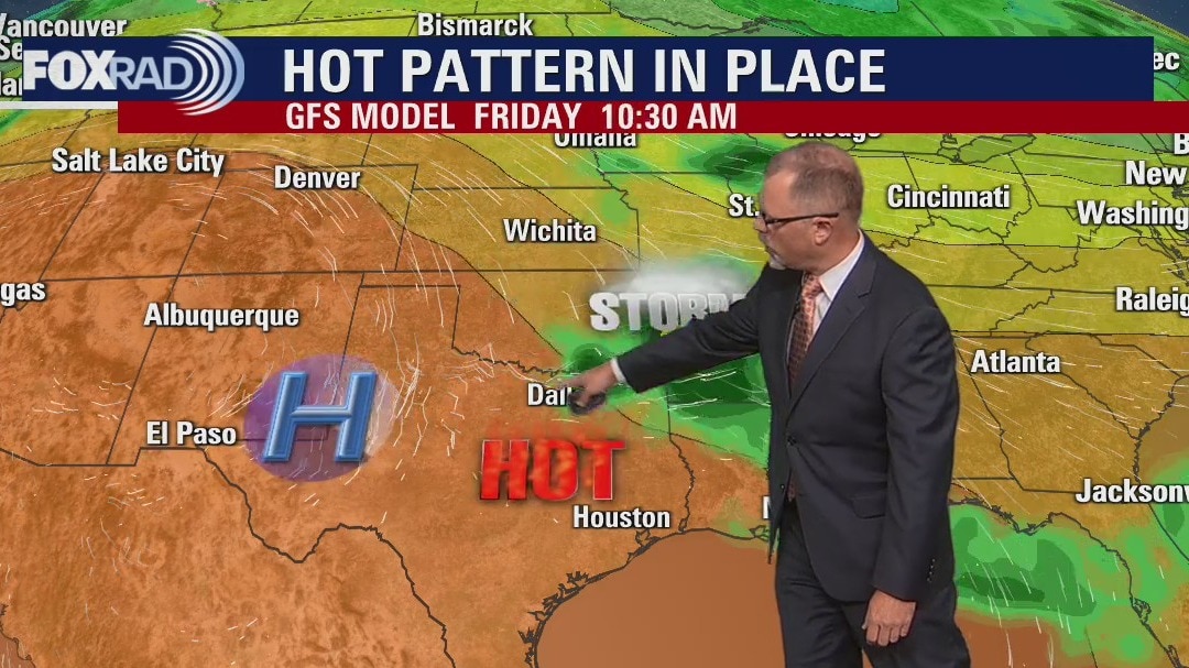
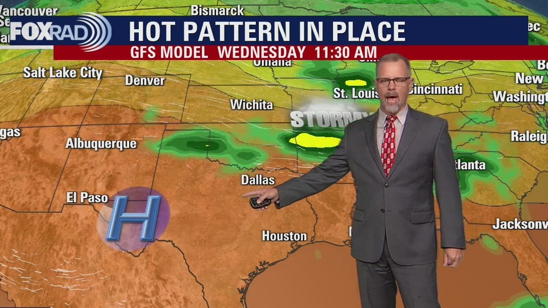
Hot week ahead in Houston
Get ready for an early season heat wave. That "big blue H" represents a large area of high pressure that will build in over West Texas bringing several days of sizzling weather from Phoenix to El Paso to Houston. Highs in central Texas and in parts of the Rio Grande Valley will experience highs ranging from 105� to 110�, while the Gulf Coast should stay in the upper 90s or slightly above 100 by this weekend. Use care to stay hydrated, get in the air conditioning whenever possible and check on vulnerable neighbors who may not have AC or who may be rationing it due to the very high cost of electricity. Finally, if Houston does hit 100�, it would be the first time since the summer of 2020 for Bush Airport and the first time in nearly three years for Sugar Land.
Get ready for an early season heat wave. That "big blue H" represents a large area of high pressure that will build in over West Texas bringing several days of sizzling weather from Phoenix to El Paso to Houston. Highs in central Texas and in parts of the Rio Grande Valley will experience highs ranging from 105� to 110�, while the Gulf Coast should stay in the upper 90s or slightly above 100 by this weekend. Use care to stay hydrated, get in the air conditioning whenever possible and check on vulnerable neighbors who may not have AC or who may be rationing it due to the very high cost of electricity. Finally, if Houston does hit 100�, it would be the first time since the summer of 2020 for Bush Airport and the first time in nearly three years for Sugar Land.
Hottest weather of the year
Get ready for the hottest weather since last August and possibly the first 100-degree day since August of 2020. A large area of high pressure will build in over Arizona and New Mexico this week and slowly creep into Texas. Highs could reach 110 in West Texas with highs near 100 here by the end of the week. Rain chances will be limited for the next few days and there are no tropical threats at this time.
Get ready for the hottest weather since last August and possibly the first 100-degree day since August of 2020. A large area of high pressure will build in over Arizona and New Mexico this week and slowly creep into Texas. Highs could reach 110 in West Texas with highs near 100 here by the end of the week. Rain chances will be limited for the next few days and there are no tropical threats at this time.
Sunday evening/Monday morning weather forecast
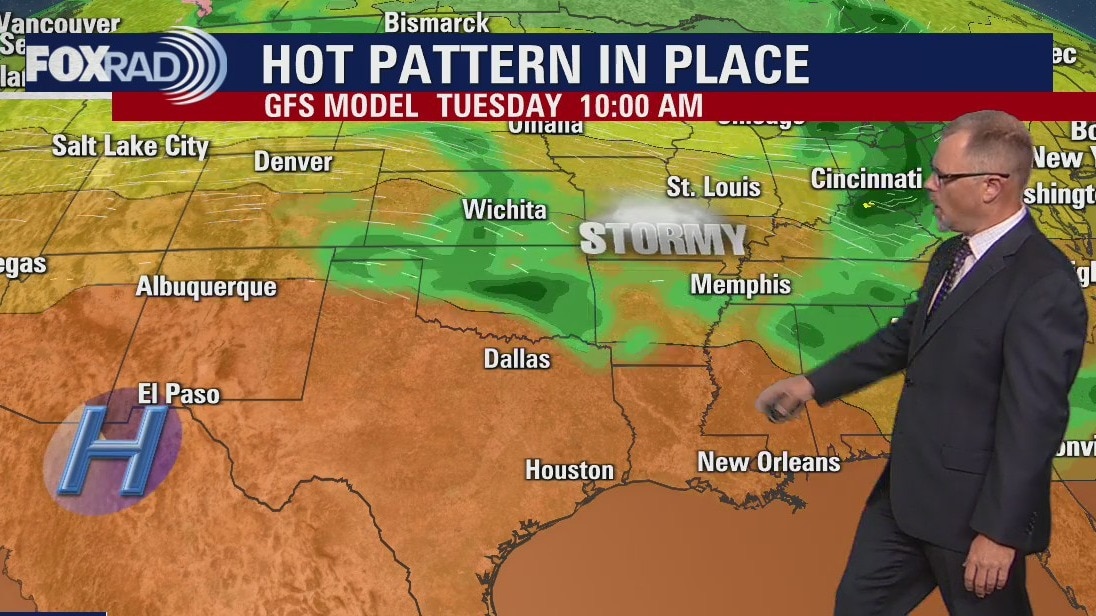
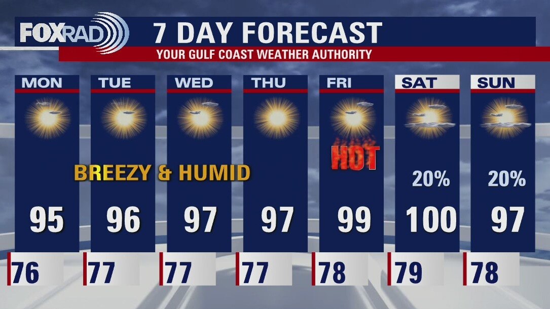
The pattern for this week is HOT and generally rain free. Actual daytime high temperatures will run in the mid 90s, with heat indices 100+ for most of the week. Keep an eye out for heat advisories, as they may get issued. Gulf breezes return, ushering in a more humid airmass. But we'll only be lucky, at best to trigger some daily showers toward the tail end of the week. Keep heat safety at top of mind for any outdoor activities, especially strenuous ones during the hottest time of the day.
The pattern for this week is HOT and generally rain free. Actual daytime high temperatures will run in the mid 90s, with heat indices 100+ for most of the week. Keep an eye out for heat advisories, as they may get issued. Gulf breezes return, ushering in a more humid airmass. But we'll only be lucky, at best to trigger some daily showers toward the tail end of the week. Keep heat safety at top of mind for any outdoor activities, especially strenuous ones during the hottest time of the day.