

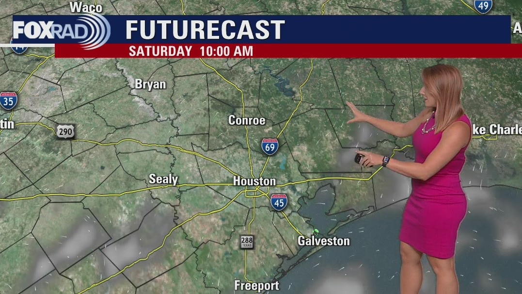
Saturday morning weather forecast
We're kicking off the weekend with more heat! Highs will soar to near 100 both Saturday and Sunday with feels like temperatures approaching 105-110. A rogue shower cannot be completely ruled out, but most locations look dry with sunshine.
We're kicking off the weekend with more heat! Highs will soar to near 100 both Saturday and Sunday with feels like temperatures approaching 105-110. A rogue shower cannot be completely ruled out, but most locations look dry with sunshine.
Friday evening weather forecast with Meteorologist Adrienne Vonn
We're kicking off the weekend with more heat! Highs will soar to near 100 both Saturday and Sunday with feels like temperatures approaching 105-110. A rogue shower cannot be completely ruled out, but most locations look dry with sunshine.
We're kicking off the weekend with more heat! Highs will soar to near 100 both Saturday and Sunday with feels like temperatures approaching 105-110. A rogue shower cannot be completely ruled out, but most locations look dry with sunshine.
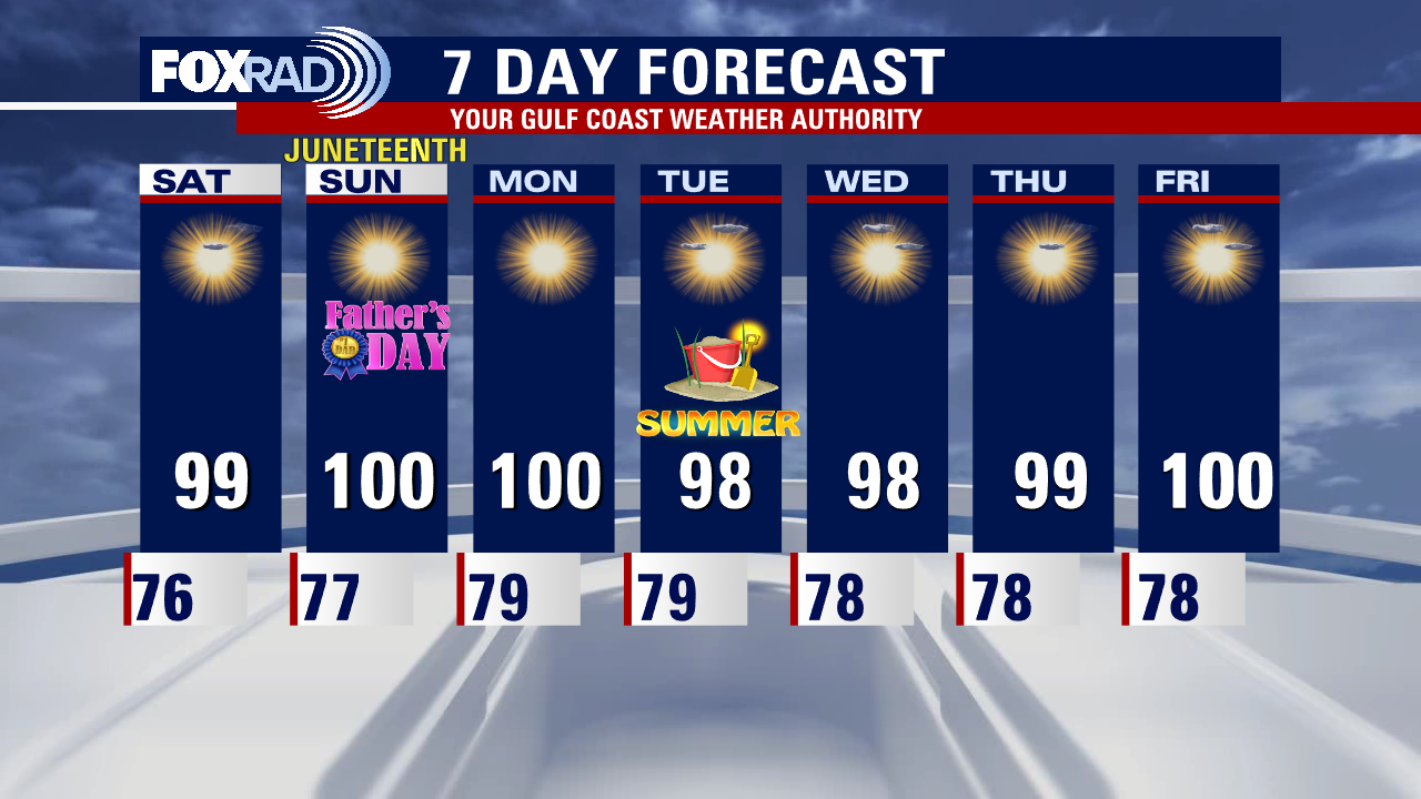
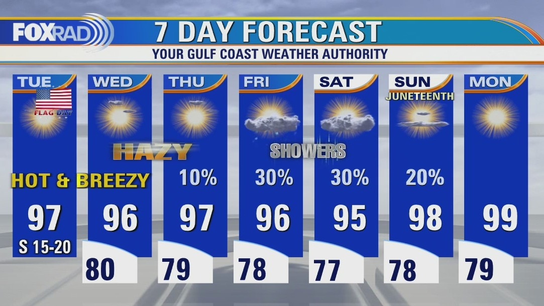
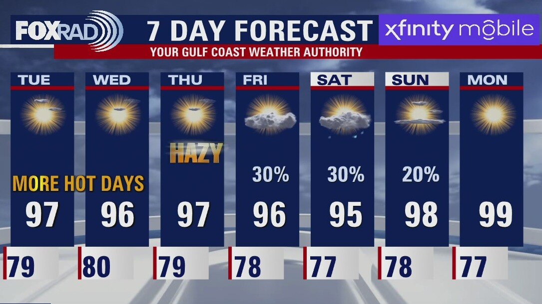
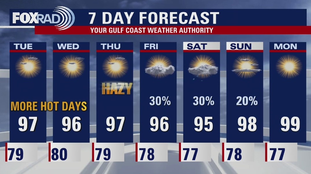
Slight chance for rain in some areas, otherwise it's hot, hot, hot
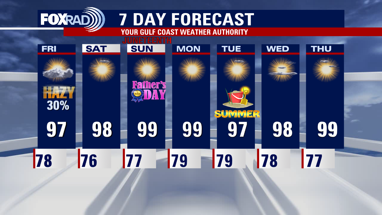
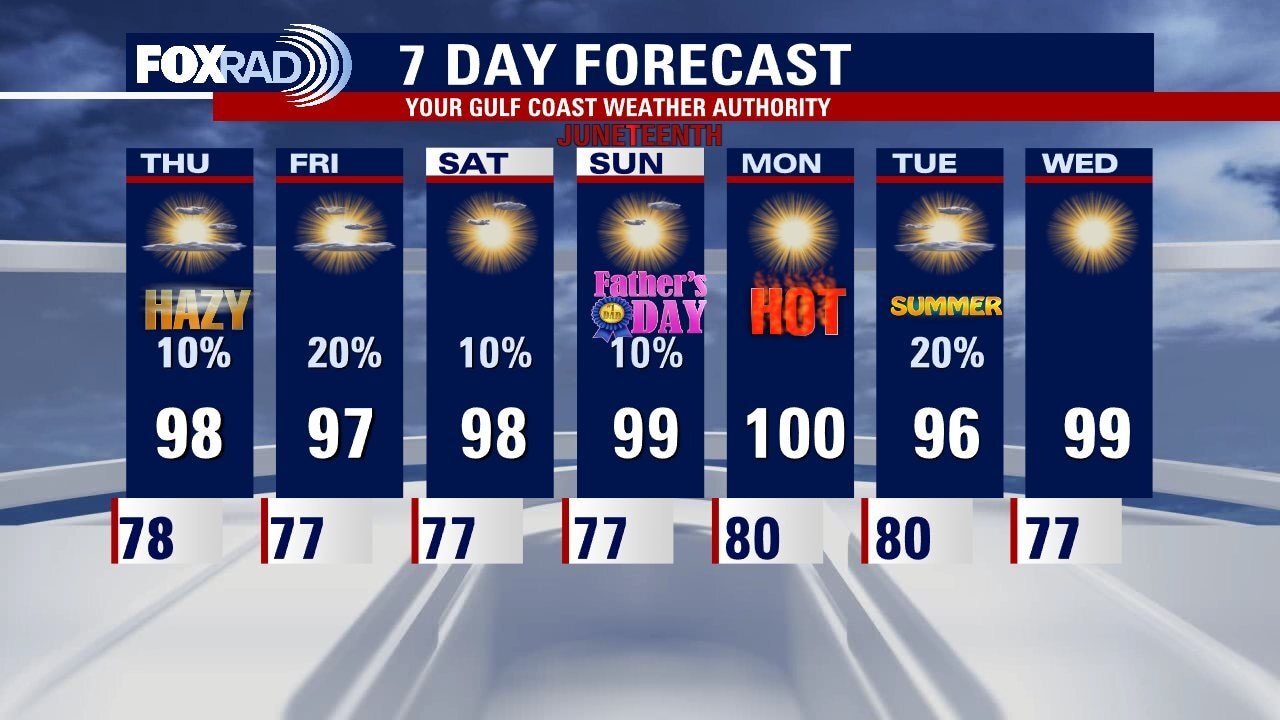
Our 30% chance for showers and isolated storms today is as high as we've had this month and the highest we're going to see for a while. Look for widely scattered showers and a few storms beginning late this morning and peaking around mid-afternoon. Aside from the lucky areas that receive rain, expect another hot day. For the Father's Day and Juneteenth weekend, there may be a rogue storm, but highs could hit 100 and that pattern isn't going away ... upper 90s are expected through next week.
Our 30% chance for showers and isolated storms today is as high as we've had this month and the highest we're going to see for a while. Look for widely scattered showers and a few storms beginning late this morning and peaking around mid-afternoon. Aside from the lucky areas that receive rain, expect another hot day. For the Father's Day and Juneteenth weekend, there may be a rogue storm, but highs could hit 100 and that pattern isn't going away ... upper 90s are expected through next week.
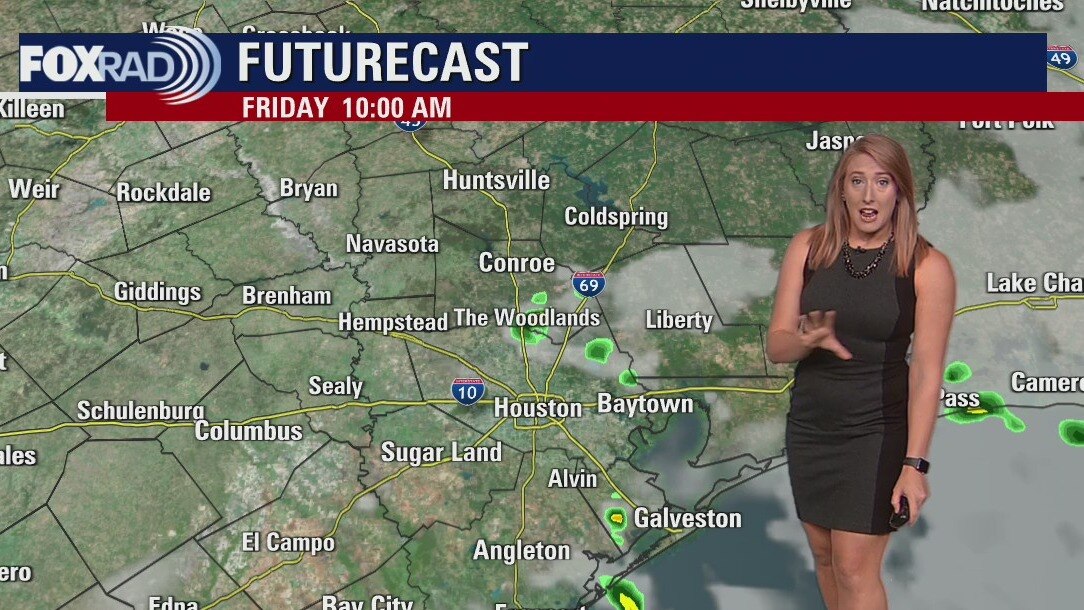
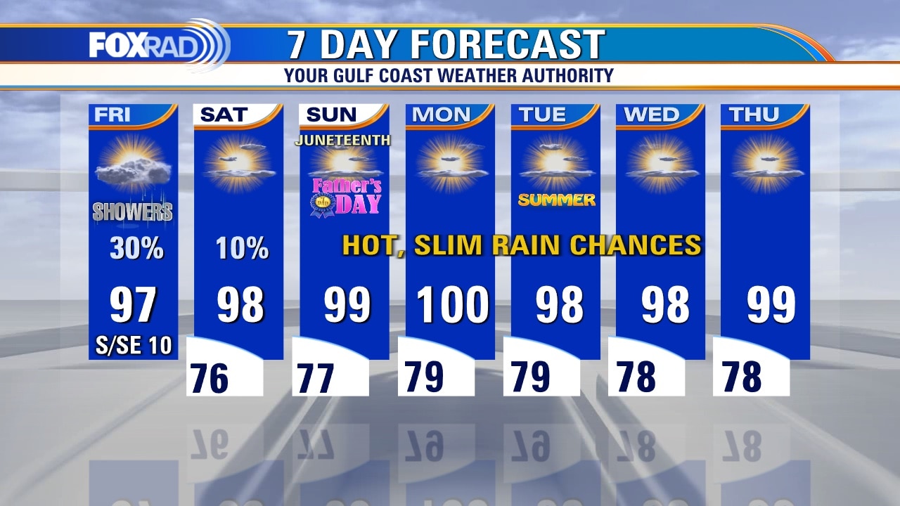
Friday morning weather forecast
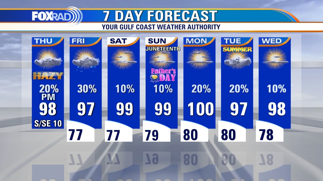
We'll wrap up the week tomorrow with hazy sunshine and a few scattered afternoon thunderstorms. The activity looks very hit or miss in variety but it's our best chance in the next week to see some rain, so we'll keep our fingers crossed! Another hot and steamy weekend is shaping up with highs soaring into the upper 90s both Saturday and Sunday. Heat index values will approach 105-108.
We'll wrap up the week tomorrow with hazy sunshine and a few scattered afternoon thunderstorms. The activity looks very hit or miss in variety but it's our best chance in the next week to see some rain, so we'll keep our fingers crossed! Another hot and steamy weekend is shaping up with highs soaring into the upper 90s both Saturday and Sunday. Heat index values will approach 105-108.
Thursday evening weather forecast with Meteorologist Adrienne Vonn
We'll wrap up the week tomorrow with hazy sunshine and a few scattered PM thunderstorms. The activity looks very hit or miss in variety but it's our best chance in the next week to see some rain, so we'll keep our fingers crossed! Another hot and steamy weekend is shaping up with highs soaring into the upper 90s both Saturday and Sunday. Heat index values will approach 105-108.
We'll wrap up the week tomorrow with hazy sunshine and a few scattered PM thunderstorms. The activity looks very hit or miss in variety but it's our best chance in the next week to see some rain, so we'll keep our fingers crossed! Another hot and steamy weekend is shaping up with highs soaring into the upper 90s both Saturday and Sunday. Heat index values will approach 105-108.
More heat & hazy skies today
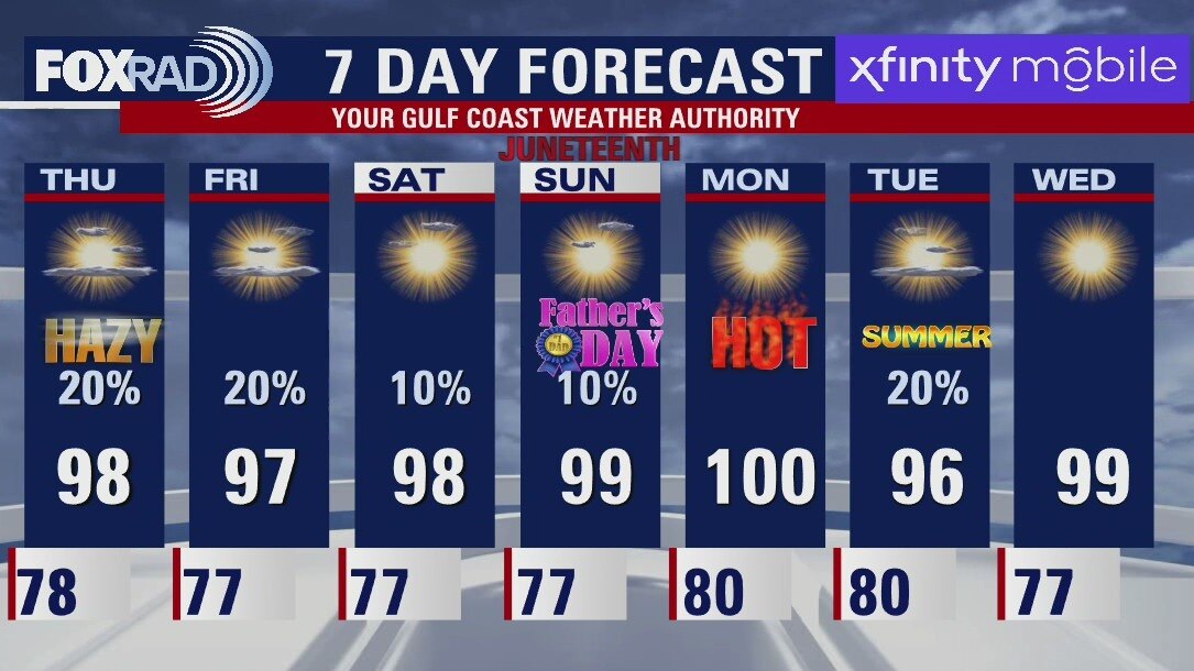
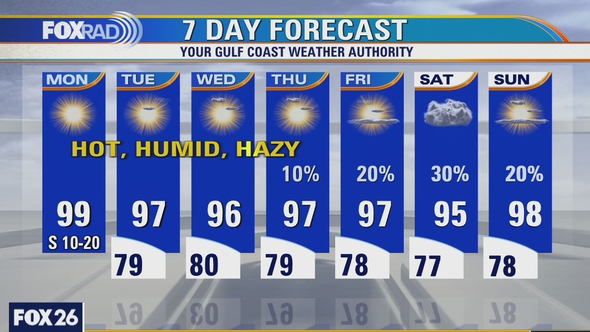
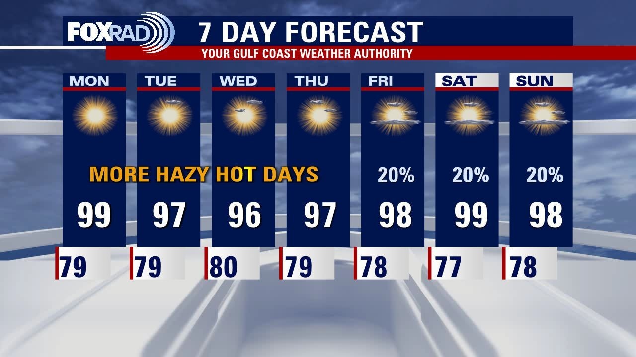
Hazy skies from Saharan Dust will linger for one more day, then we'll see a wind shift over the weekend that should lessen that. Our best shot at rain is tomorrow, and then Tuesday and Wednesday of next week. Over the weekend for any outdoor Father's Day plans or Juneteenth celebrations, it will be more about beating the heat than dodging raindrops. We could see Heat Advisories get issued as actual temperatures near 100 and Heat Indices approach the 105-108 range. There is some activity in the tropics, but everything is staying away from us for now. Stay safe and cool out there!
Hazy skies from Saharan Dust will linger for one more day, then we'll see a wind shift over the weekend that should lessen that. Our best shot at rain is tomorrow, and then Tuesday and Wednesday of next week. Over the weekend for any outdoor Father's Day plans or Juneteenth celebrations, it will be more about beating the heat than dodging raindrops. We could see Heat Advisories get issued as actual temperatures near 100 and Heat Indices approach the 105-108 range. There is some activity in the tropics, but everything is staying away from us for now. Stay safe and cool out there!
More heat, humidity & haze
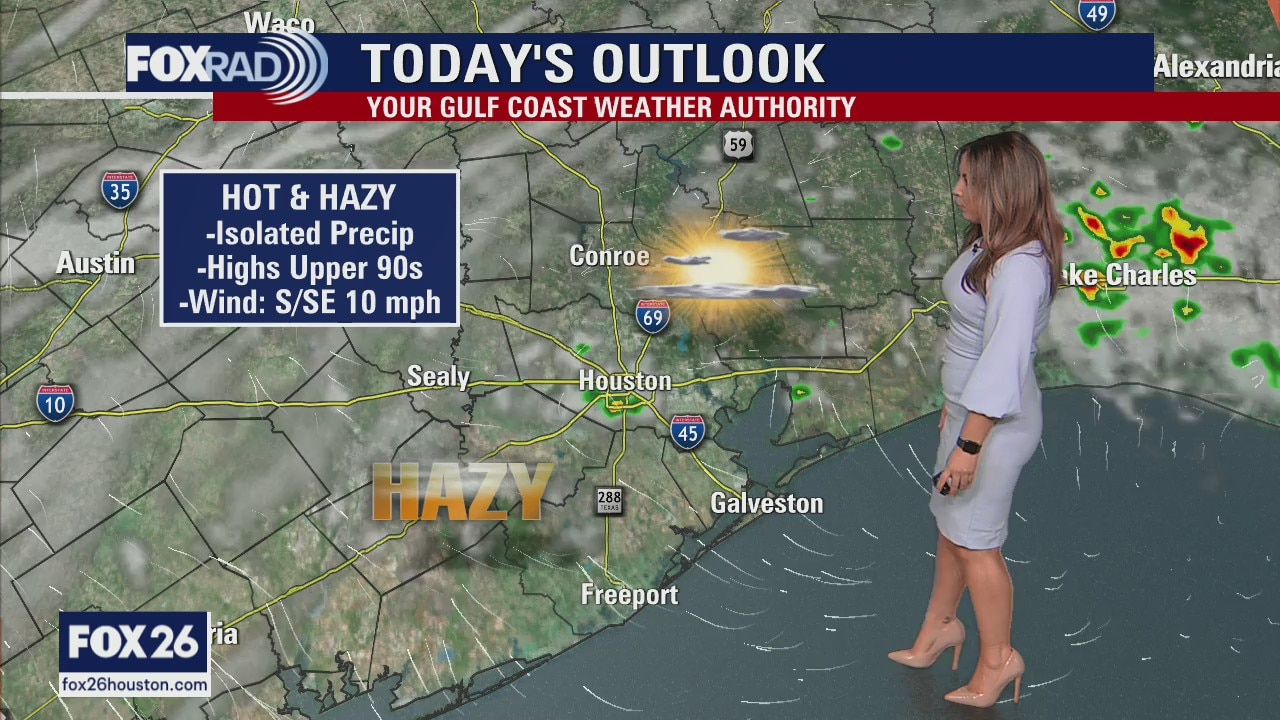
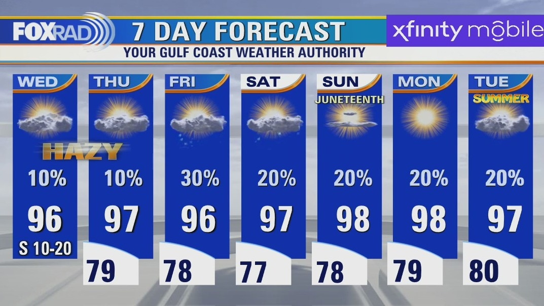
More heat, humidity, and haze are on the way today as we continue what has been 11 consecutive days with above-normal high temperatures. In fact, as of today, both Houston and Galveston are on pace for the warmest June on record - and these records go back to the late 1800s! There will be a chance for an isolated shower late today, then a decent chance for scattered storms Friday, but in general we're expecting a continuation of a familiar, hot pattern.
More heat, humidity, and haze are on the way today as we continue what has been 11 consecutive days with above-normal high temperatures. In fact, as of today, both Houston and Galveston are on pace for the warmest June on record - and these records go back to the late 1800s! There will be a chance for an isolated shower late today, then a decent chance for scattered storms Friday, but in general we're expecting a continuation of a familiar, hot pattern.
Thursday morning weather forecast
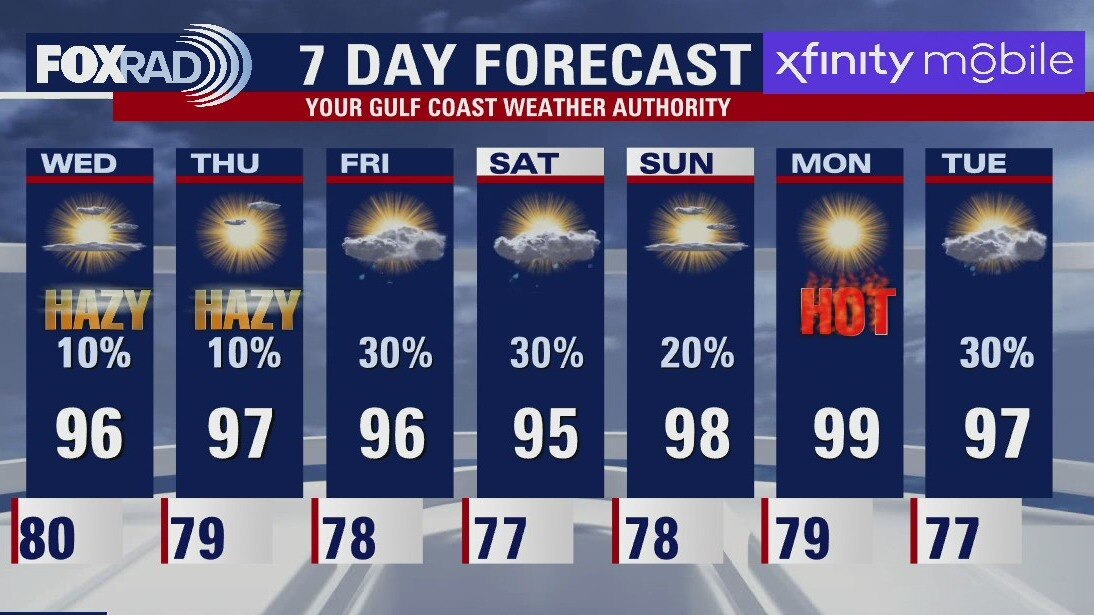
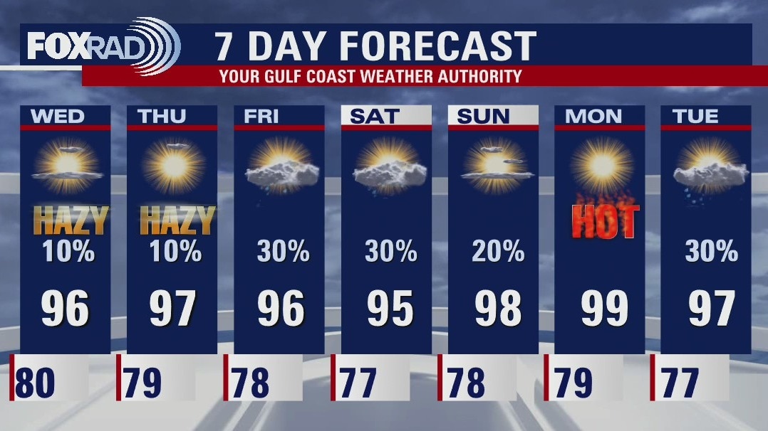
Even more Saharan Dust moves into Southeast Texas Wednesday afternoon keeping hazy conditions in the forecast for Houston. It has been a while since there has been measurable rain across the area, so most will welcome a shower or downpour on Friday or Saturday. More upper 90s return for the end of the weekend and the start of next week.
Even more Saharan Dust moves into Southeast Texas Wednesday afternoon keeping hazy conditions in the forecast for Houston. It has been a while since there has been measurable rain across the area, so most will welcome a shower or downpour on Friday or Saturday. More upper 90s return for the end of the weekend and the start of next week.
Wednesday evening weather forecast with Meteorologist John Dawson
The Saharan Haze settles in across Houston for Thursday. Very isolated chances for rain in the afternoon with those low chances again on Friday. Father's Day Weekend looks hot! Be safe with all your outdoor activities.
The Saharan Haze settles in across Houston for Thursday. Very isolated chances for rain in the afternoon with those low chances again on Friday. Father's Day Weekend looks hot! Be safe with all your outdoor activities.
Hot, humid weather continues
Our long string of above-average, humid weather will continue for the rest of the week and into the Juneteenth holiday. The latest plume of Saharan dust will arrive today and Thursday leading to a noticeable haze in the sky and a moderate effect on our air quality. Otherwise, there is a slight chance for a few small showers today and even isolated storms late tomorrow. Our best chance for rain (and it isn't a big chance) is Friday.
Our long string of above-average, humid weather will continue for the rest of the week and into the Juneteenth holiday. The latest plume of Saharan dust will arrive today and Thursday leading to a noticeable haze in the sky and a moderate effect on our air quality. Otherwise, there is a slight chance for a few small showers today and even isolated storms late tomorrow. Our best chance for rain (and it isn't a big chance) is Friday.
Wednesday morning weather forecast
Even more Saharan Dust will move into Southeast Texas Wednesday afternoon keeping hazy conditions in the forecast for Houston. It has been a while since there has been measurable rain across the area, so most will welcome a shower or downpour on Friday or Saturday. More upper 90s return for the end of the weekend and the start of next week.
Even more Saharan Dust will move into Southeast Texas Wednesday afternoon keeping hazy conditions in the forecast for Houston. It has been a while since there has been measurable rain across the area, so most will welcome a shower or downpour on Friday or Saturday. More upper 90s return for the end of the weekend and the start of next week.
Tuesday evening weather forecast
Even more Saharan Dust moves into Southeast Texas Wednesday afternoon keeping hazy conditions in the forecast for Houston. It has been a while since there has been measurable rain across the area, so most will welcome a shower or downpour on Friday or Saturday. More upper 90s return for the end of the weekend and the start of next week.
Even more Saharan Dust moves into Southeast Texas Wednesday afternoon keeping hazy conditions in the forecast for Houston. It has been a while since there has been measurable rain across the area, so most will welcome a shower or downpour on Friday or Saturday. More upper 90s return for the end of the weekend and the start of next week.
More heat, Saharan dust & a muggy breeze
Heat, a muggy breeze and more Saharan dust are all in the forecast through Thursday. Highs should remain below records this week, but we will continue our streak of above-normal highs and lows. In all, we expect above-normal temps for the foreseeable future. Watch for thickening Saharan dust for Wednesday and Thursday along with the potential for air quality issues from dust suspended in the atmosphere. Some help may be on the way with scattered showers/storms on Friday and Saturday.
Heat, a muggy breeze and more Saharan dust are all in the forecast through Thursday. Highs should remain below records this week, but we will continue our streak of above-normal highs and lows. In all, we expect above-normal temps for the foreseeable future. Watch for thickening Saharan dust for Wednesday and Thursday along with the potential for air quality issues from dust suspended in the atmosphere. Some help may be on the way with scattered showers/storms on Friday and Saturday.
More heat, Saharan dust and a muggy breeze ahead
Heat, a muggy breeze, and more Saharan dust are all in the forecast through Thursday. Highs should remain below records this week, but we will continue our streak of above-normal highs and lows. In all, we expect above-normal temps for the foreseeable future. Watch for thickening Saharan dust on Wednesday and Thursday along with the potential for air quality issues from dust suspended in the atmosphere. Some help may be on the way with scattered showers and storms on Friday and Saturday.
Heat, a muggy breeze, and more Saharan dust are all in the forecast through Thursday. Highs should remain below records this week, but we will continue our streak of above-normal highs and lows. In all, we expect above-normal temps for the foreseeable future. Watch for thickening Saharan dust on Wednesday and Thursday along with the potential for air quality issues from dust suspended in the atmosphere. Some help may be on the way with scattered showers and storms on Friday and Saturday.
Tuesday morning weather forecast
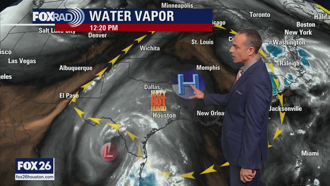
The heat wave continues for southeast Texas. Look for more upper 90s to start the week in Houston and keep practicing all you heat safety precautions. Another thick batch of Saharan Dust will arrive on Thursday worsening air quality and making the skies very hazy. Hopefully there will be a few much needed showers/storms around to start the weekend.
The heat wave continues for southeast Texas. Look for more upper 90s to start the week in Houston and keep practicing all you heat safety precautions. Another thick batch of Saharan Dust will arrive on Thursday worsening air quality and making the skies very hazy. Hopefully there will be a few much needed showers/storms around to start the weekend.
Monday evening weather forecast
The heat wave continues for southeast Texas. Look for more upper 90s to start the week in Houston and keep practicing all you heat safety precautions. Another thick batch of Saharan Dust will arrive on Thursday worsening air quality and making the skies very hazy. Hopefully there will be a few much needed showers/storms around to start the weekend.
The heat wave continues for southeast Texas. Look for more upper 90s to start the week in Houston and keep practicing all you heat safety precautions. Another thick batch of Saharan Dust will arrive on Thursday worsening air quality and making the skies very hazy. Hopefully there will be a few much needed showers/storms around to start the weekend.

Saharan dust blows in, joining the ongoing Houston heat wave
Saharan dust arrived this past weekend, bringing hazy skies and impacting air quality for sensitive groups in Houston, which is already experiencing a dangerous heat wave.
Saharan dust arrived this past weekend, bringing hazy skies and impacting air quality for sensitive groups in Houston, which is already experiencing a dangerous heat wave.
Hot, humid & hazy days ahead
Our heat wave continues and should stick around for most of the week. You also may notice hazy skies today and tomorrow after the arrival of a layer of Saharan dust this past weekend. In fact, air quality may be affected a bit by elevated levels of "particulate matter," which is basically microscopic dust. It won't bother most people, but those sensitive to it should avoid strenuous activity outdoors (which you would anyway due to the heat). Look for highs in the upper 90s today and mid to upper 90s for the rest of the week. We may finally see scattered storms late this week.
Our heat wave continues and should stick around for most of the week. You also may notice hazy skies today and tomorrow after the arrival of a layer of Saharan dust this past weekend. In fact, air quality may be affected a bit by elevated levels of "particulate matter," which is basically microscopic dust. It won't bother most people, but those sensitive to it should avoid strenuous activity outdoors (which you would anyway due to the heat). Look for highs in the upper 90s today and mid to upper 90s for the rest of the week. We may finally see scattered storms late this week.
Sunday night leading into Monday morning weather forecast
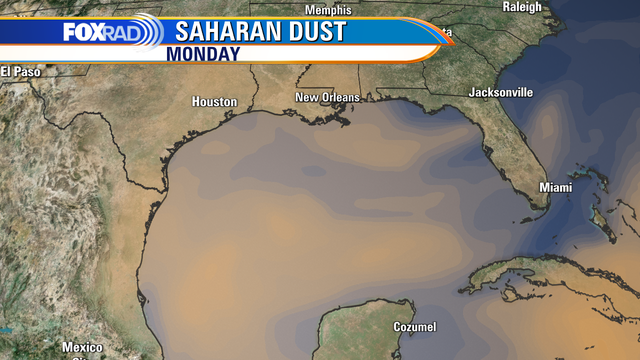
The heat continues for the state of Texas! Houston will see a barely noticeable decrease in temperatures for the start of the work week as breezes kick up out of the south, but that should keep us just shy of Heat Advisory Criteria. Nonetheless, it will be another hot and dry week so keep heat safety in mind throughout for you and your loved ones.
The heat continues for the state of Texas! Houston will see a barely noticeable decrease in temperatures for the start of the work week as breezes kick up out of the south, but that should keep us just shy of Heat Advisory Criteria. Nonetheless, it will be another hot and dry week so keep heat safety in mind throughout for you and your loved ones.
Sunday Morning Forecast with Meteorologist Lena Maria
For the second day in a row, a Heat Advisory blankets not only our entire local area but most of the state of Texas. Actual high temperatures will soar to near 100, with feels like values up to 111 in some spots. A barely noticeable decrease in temperatures arrives for the work week as breezes kick up out of the south, but that should keep us just shy of Heat Advisory Criteria. None the less, it will be another hot and dry week so keep heat safety in mind throughout for you, the kiddos and the pets!
For the second day in a row, a Heat Advisory blankets not only our entire local area but most of the state of Texas. Actual high temperatures will soar to near 100, with feels like values up to 111 in some spots. A barely noticeable decrease in temperatures arrives for the work week as breezes kick up out of the south, but that should keep us just shy of Heat Advisory Criteria. None the less, it will be another hot and dry week so keep heat safety in mind throughout for you, the kiddos and the pets!