


Wednesday evening weather forecast with Meteorologist John Dawson
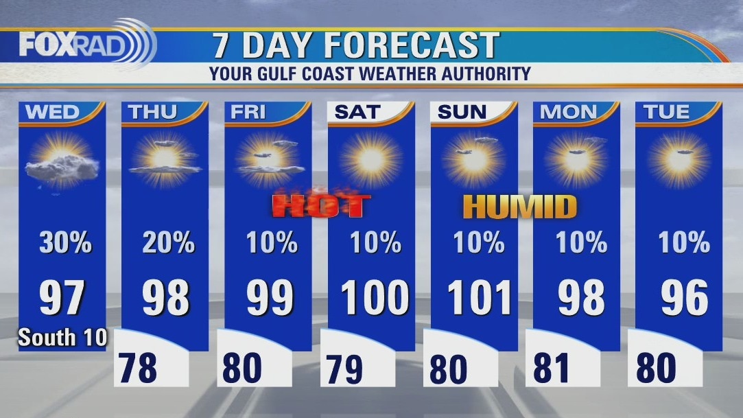
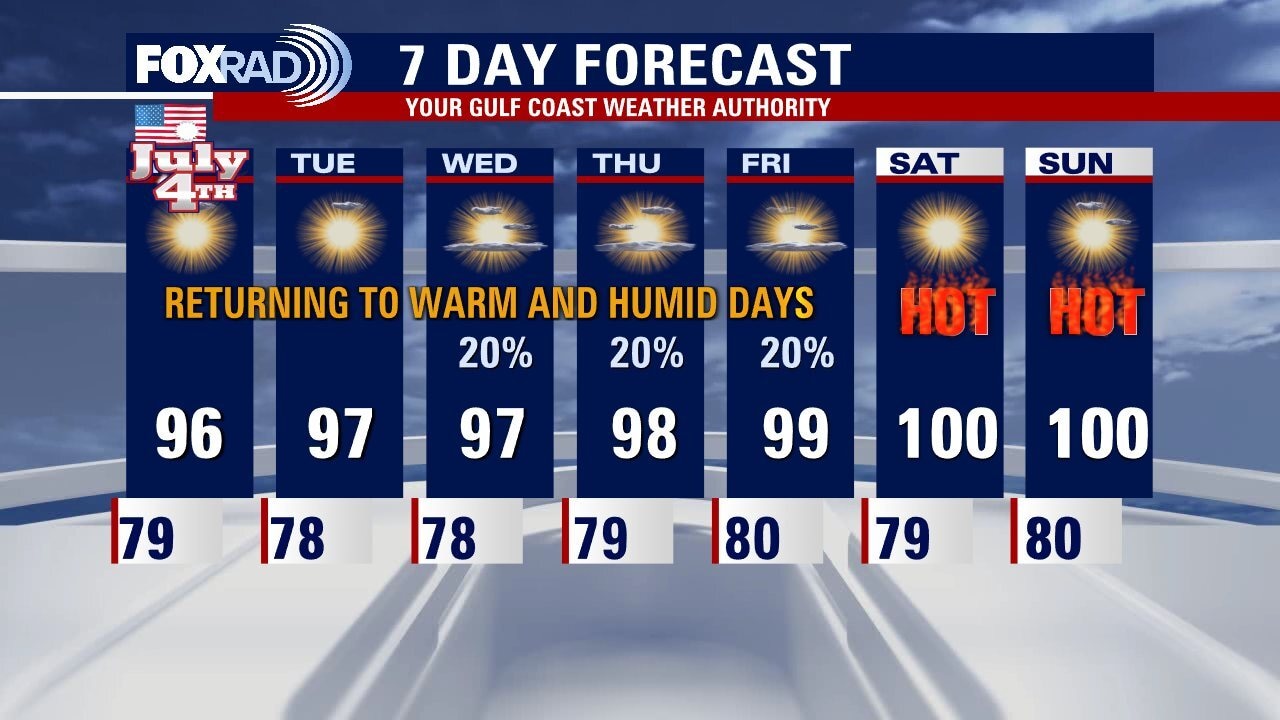
More hot and humid days are ahead for Houston as an area of high pressure builds back in over Southeast Texas. Rain chances decrease as we get closer to the weekend and triple digits should be here for Saturday and Sunday. Heat Advisories may also be needed. Be safe with all the weekend outdoors activities
More hot and humid days are ahead for Houston as an area of high pressure builds back in over Southeast Texas. Rain chances decrease as we get closer to the weekend and triple digits should be here for Saturday and Sunday. Heat Advisories may also be needed. Be safe with all the weekend outdoors activities
Very warm and humid Wednesday with isolated afternoon storms possible
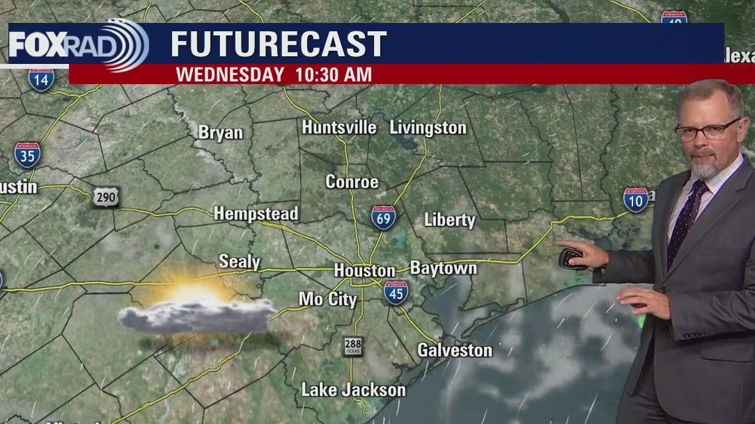
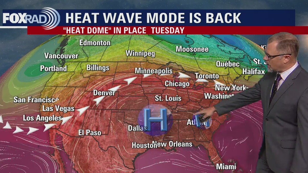
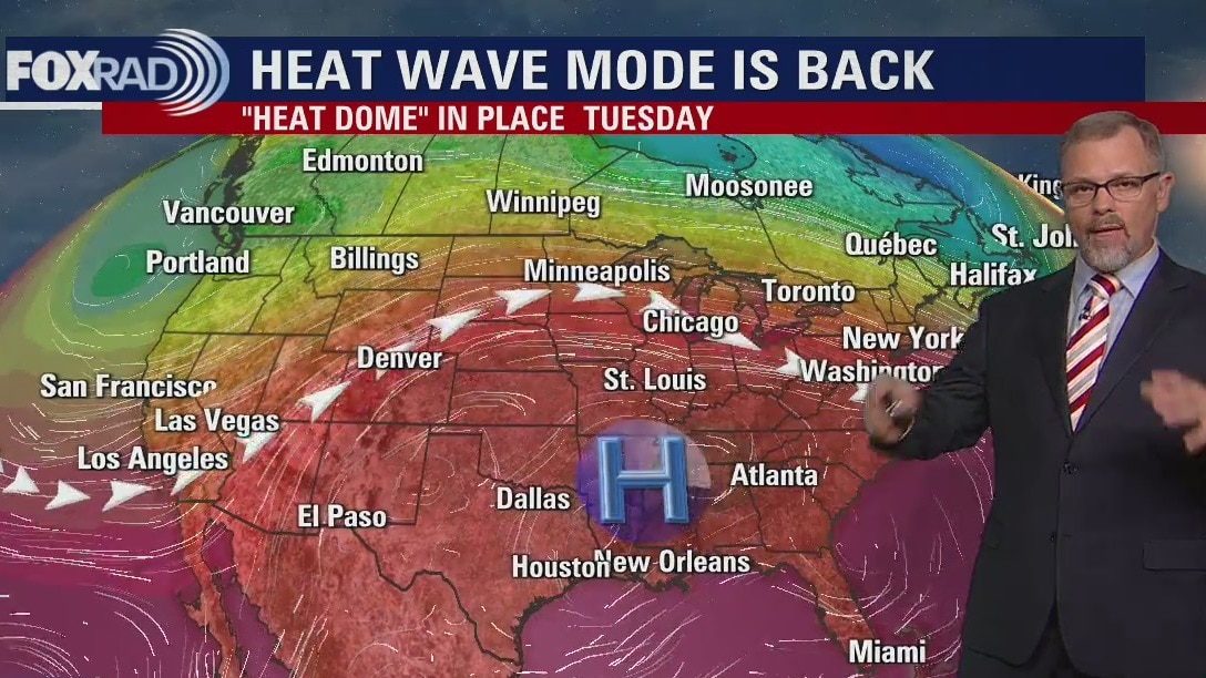
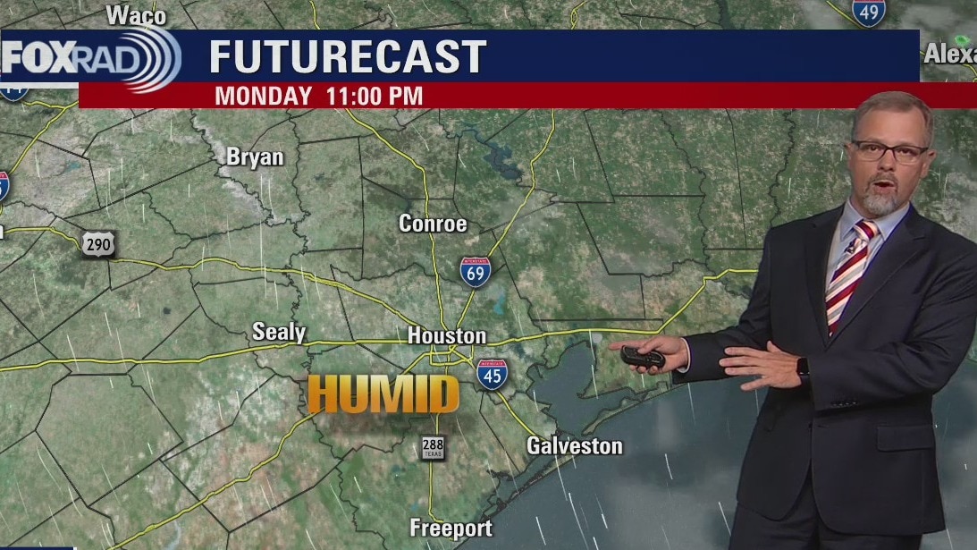
Today will still end up very warm and humid, but an area of high pressure (the "heat dome"), has shifted slightly to the north and will allow more moisture to slide into Texas from Louisiana. As a result, isolated thunderstorms are expected and a few brief, heavy downpours are possible. Otherwise, the story remains focused on daily highs near 100 and possible heat advisories by the end of the week.
Today will still end up very warm and humid, but an area of high pressure (the "heat dome"), has shifted slightly to the north and will allow more moisture to slide into Texas from Louisiana. As a result, isolated thunderstorms are expected and a few brief, heavy downpours are possible. Otherwise, the story remains focused on daily highs near 100 and possible heat advisories by the end of the week.
Wednesday morning weather forecast
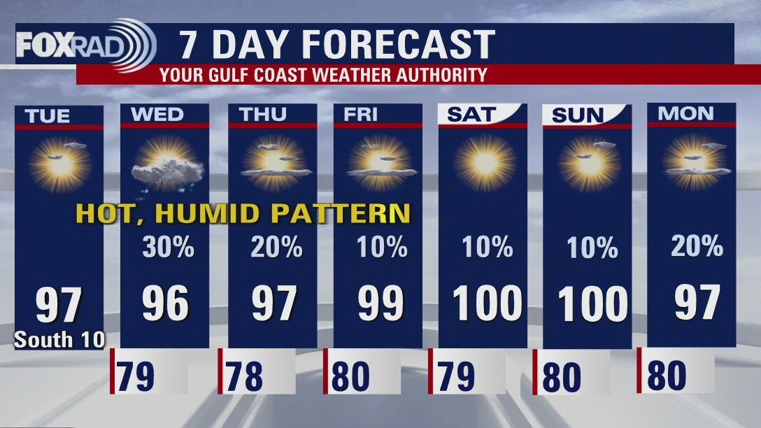
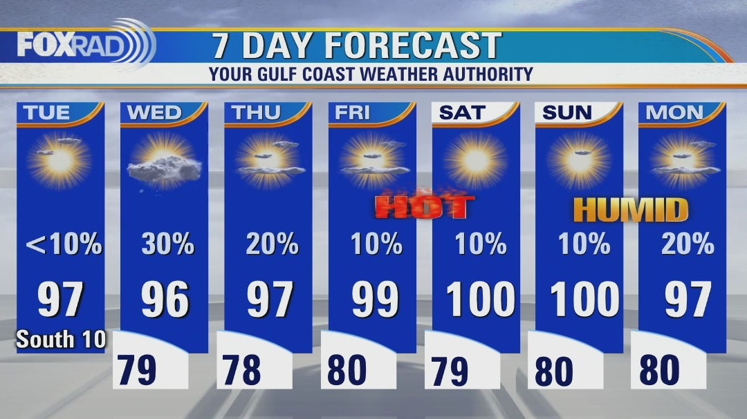
The heat wave is back in Southeast Texas but Wednesday may see a few isolated storms. There won't be many but if you see some rain, it could be a brief heavy downpour. Rain chances decrease as we move closer to the weekend. Get ready for triple digits on Saturday and Sunday.
The heat wave is back in Southeast Texas but Wednesday may see a few isolated storms. There won't be many but if you see some rain, it could be a brief heavy downpour. Rain chances decrease as we move closer to the weekend. Get ready for triple digits on Saturday and Sunday.
Tuesday evening weather forecast
The heat wave is back in Southeast Texas but Wednesday may see a few isolated storms. There won't be many but if you see some rain, it could be a brief heavy downpour. Rain chances decrease as we move closer to the weekend. Get ready for triple digits on Saturday and Sunday.
The heat wave is back in Southeast Texas but Wednesday may see a few isolated storms. There won't be many but if you see some rain, it could be a brief heavy downpour. Rain chances decrease as we move closer to the weekend. Get ready for triple digits on Saturday and Sunday.
Heat wave returns with hot and humid weather
No surprises today - it's going to be another steamy sauna with highs in the upper 90s and a heat index near 105. Scattered storms could make a brief return tomorrow with a slight chance Thursday as well, but overall our forecast stays very hot and humid with heat advisories possible late this week. The tropics remain quiet for now.
No surprises today - it's going to be another steamy sauna with highs in the upper 90s and a heat index near 105. Scattered storms could make a brief return tomorrow with a slight chance Thursday as well, but overall our forecast stays very hot and humid with heat advisories possible late this week. The tropics remain quiet for now.
Mostly sunny, hot and humid Tuesday
No surprises today - it's going to be another steamy sauna with highs in the upper 90s and a heat index near 105. Scattered storms could make a brief return tomorrow with a slight chance Thursday as well, but overall our forecast stays very hot and humid with heat advisories possible late this week. The tropics remain quiet for now.
No surprises today - it's going to be another steamy sauna with highs in the upper 90s and a heat index near 105. Scattered storms could make a brief return tomorrow with a slight chance Thursday as well, but overall our forecast stays very hot and humid with heat advisories possible late this week. The tropics remain quiet for now.
Tuesday morning weather forecast
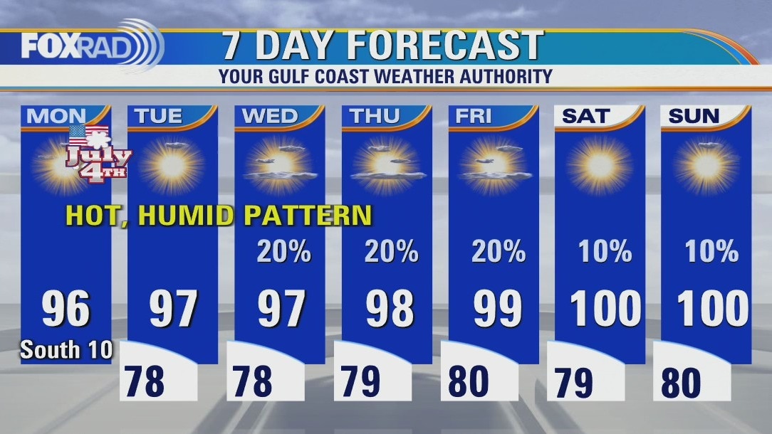
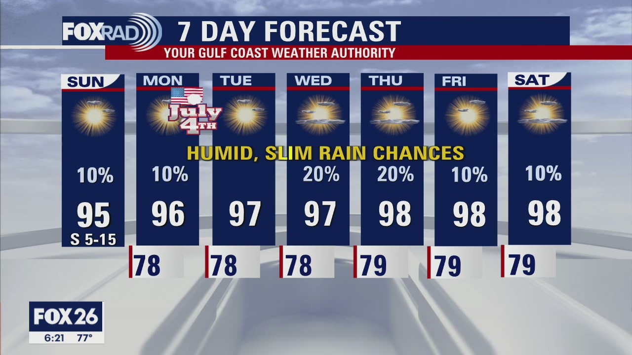
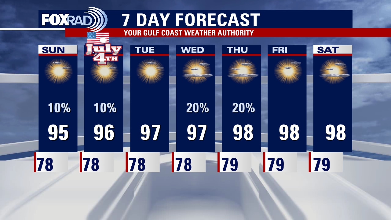
The 4th of July holiday will give us a taste of what is to come for the rest of the week. A heat wave is building back into Southeast Texas and hot temperatures with slim chances of rain dominate the forecast. Houston will probably see triple digits again next weekend. Rain chances are not "zero" this week but they remain low.
The 4th of July holiday will give us a taste of what is to come for the rest of the week. A heat wave is building back into Southeast Texas and hot temperatures with slim chances of rain dominate the forecast. Houston will probably see triple digits again next weekend. Rain chances are not "zero" this week but they remain low.
Monday evening weather forecast
The Fourth of July holiday will give us a taste of what is to come for the rest of the week. A heat wave is building back into Southeast Texas and hot temperatures with slim chances of rain dominate the forecast. Houston will probably see triple digits again next weekend. Rain chances are not "zero" this week but they remain low.
The Fourth of July holiday will give us a taste of what is to come for the rest of the week. A heat wave is building back into Southeast Texas and hot temperatures with slim chances of rain dominate the forecast. Houston will probably see triple digits again next weekend. Rain chances are not "zero" this week but they remain low.
Mostly sunny, hot and humid with highs in the mid 90s
After rounds of heavy rain late last week, we are back in "heat wave mode" this week with daily high temps in the mid to upper 90s and even low 100s by the end of this week. Be careful with fireworks tonight because conditions are still favorable for fires, especially in areas that did not receive rain last week. Weather for 4th of July displays tonight looks warm and humid with rain not likely.
After rounds of heavy rain late last week, we are back in "heat wave mode" this week with daily high temps in the mid to upper 90s and even low 100s by the end of this week. Be careful with fireworks tonight because conditions are still favorable for fires, especially in areas that did not receive rain last week. Weather for 4th of July displays tonight looks warm and humid with rain not likely.
Sunday night leading into Fourth of July weather forecast
Independence Day looks typical for Houston this year. Warm and muggy with an isolated stray shower possible in the afternoon, but not likely. Feels like temps will still be in the 90s at 9 p.m. when most fireworks shows are set to launch. Be safe outdoors in the heat. Plan for increasing warmth and humidity, with low rain chances as we move through the week. Triple digits return to the forecast for next weekend.
Independence Day looks typical for Houston this year. Warm and muggy with an isolated stray shower possible in the afternoon, but not likely. Feels like temps will still be in the 90s at 9 p.m. when most fireworks shows are set to launch. Be safe outdoors in the heat. Plan for increasing warmth and humidity, with low rain chances as we move through the week. Triple digits return to the forecast for next weekend.
Sunday Morning Forecast with Meteorologist Lena Maria
After the most unsettled weather we've seen in southeast Texas in a while, we will transition back to a hot and dry pattern as another ridge of high pressure takes over. Plan for increasing warmth and humidity, with rain chances on the low to non-existent side. With that being said, burn bans remain in place in many counties so be extremely cautious with outdoor flame. Though there is some action in the tropics, nothing is headed our way.
After the most unsettled weather we've seen in southeast Texas in a while, we will transition back to a hot and dry pattern as another ridge of high pressure takes over. Plan for increasing warmth and humidity, with rain chances on the low to non-existent side. With that being said, burn bans remain in place in many counties so be extremely cautious with outdoor flame. Though there is some action in the tropics, nothing is headed our way.
Saturday night leading into Sunday morning weather forecast
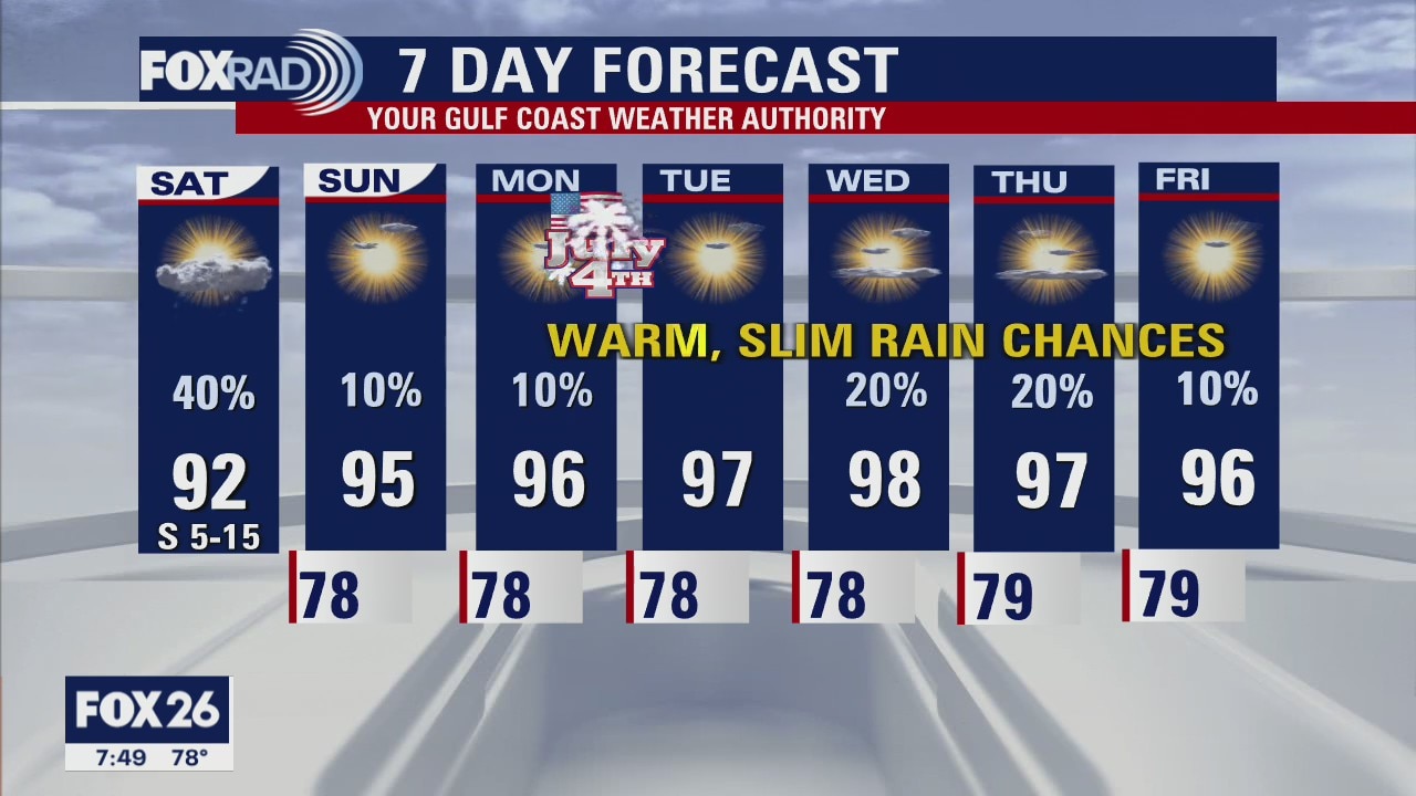
Drier and hotter conditions are setting up for the rest of the 4th of July Holiday weekend. While a stray shower cannot be completely ruled out Sunday or Monday, most locations will stay dry with sunshine. Temperatures will be heating up quickly, with highs climbing into the mid-90s and heat index values soaring into the triple digits. We'll trend even hotter thru the middle to end of next week.
Drier and hotter conditions are setting up for the rest of the 4th of July Holiday weekend. While a stray shower cannot be completely ruled out Sunday or Monday, most locations will stay dry with sunshine. Temperatures will be heating up quickly, with highs climbing into the mid-90s and heat index values soaring into the triple digits. We'll trend even hotter thru the middle to end of next week.
FOX 26 Weekend Morning News
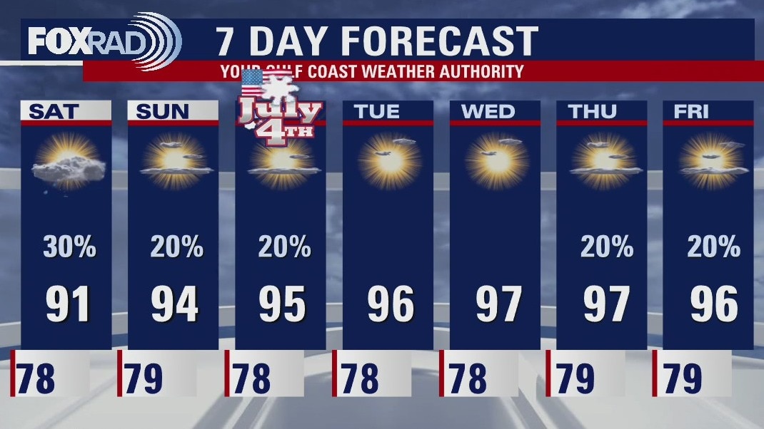
Fourth of July weekend will feature a gradual drying and warming trend, with Saturday being our best chance for any additional rain. A ridge of high pressure will take over next week, bringing an increase to both temperatures and humidity and keeping rain chances fairly slim. Lots brewing in the tropics, though nothing that will affect us locally for now. We have crossed off both the B and C name in the last 24 hours!
Fourth of July weekend will feature a gradual drying and warming trend, with Saturday being our best chance for any additional rain. A ridge of high pressure will take over next week, bringing an increase to both temperatures and humidity and keeping rain chances fairly slim. Lots brewing in the tropics, though nothing that will affect us locally for now. We have crossed off both the B and C name in the last 24 hours!
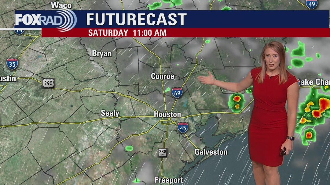
Saturday morning weather forecast
A few scattered showers and thunderstorms are still possible into Saturday with temperatures still running below average. The remainder of the July 4th Holiday weekend is trending drier and hotter. While an isolated thunderstorm cannot be ruled out, many locations will stay dry and sunny. Temperatures heat back up next week, with highs back in the upper 90s by Wednesday.
A few scattered showers and thunderstorms are still possible into Saturday with temperatures still running below average. The remainder of the July 4th Holiday weekend is trending drier and hotter. While an isolated thunderstorm cannot be ruled out, many locations will stay dry and sunny. Temperatures heat back up next week, with highs back in the upper 90s by Wednesday.
Friday evening weather forecast
A few scattered showers and thunderstorms are still possible into Saturday with temperatures still running below average. The remainder of the July 4 Holiday weekend is trending drier and hotter. While an isolated thunderstorm cannot be ruled out, many locations will stay dry and sunny. Temperatures heat back up next week, with highs back in the upper 90s by Wednesday.
A few scattered showers and thunderstorms are still possible into Saturday with temperatures still running below average. The remainder of the July 4 Holiday weekend is trending drier and hotter. While an isolated thunderstorm cannot be ruled out, many locations will stay dry and sunny. Temperatures heat back up next week, with highs back in the upper 90s by Wednesday.
More rain before a nice-looking holiday
After scattered downpours earlier today, lingering moisture will bring another round of scattered showers and storms to the area tomorrow. Plus another day of cooler temperatures. Warm, humid, dry weather begins to emerge on Sunday with a transition day. Things look great for the July 4th holiday and beyond!
After scattered downpours earlier today, lingering moisture will bring another round of scattered showers and storms to the area tomorrow. Plus another day of cooler temperatures. Warm, humid, dry weather begins to emerge on Sunday with a transition day. Things look great for the July 4th holiday and beyond!
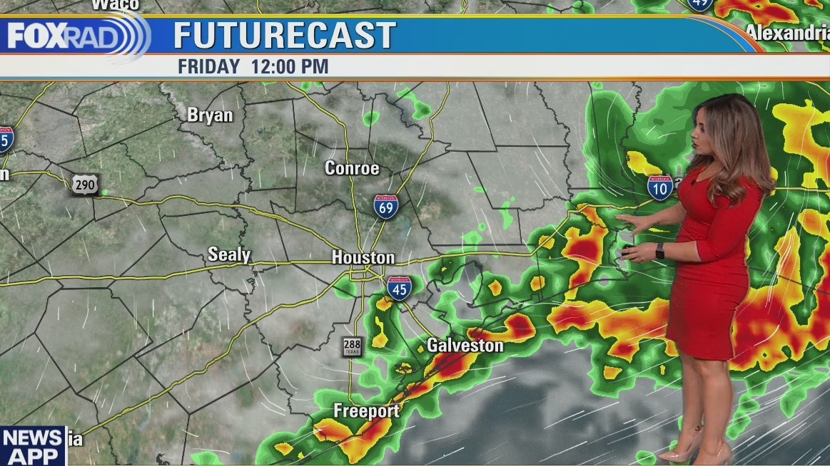
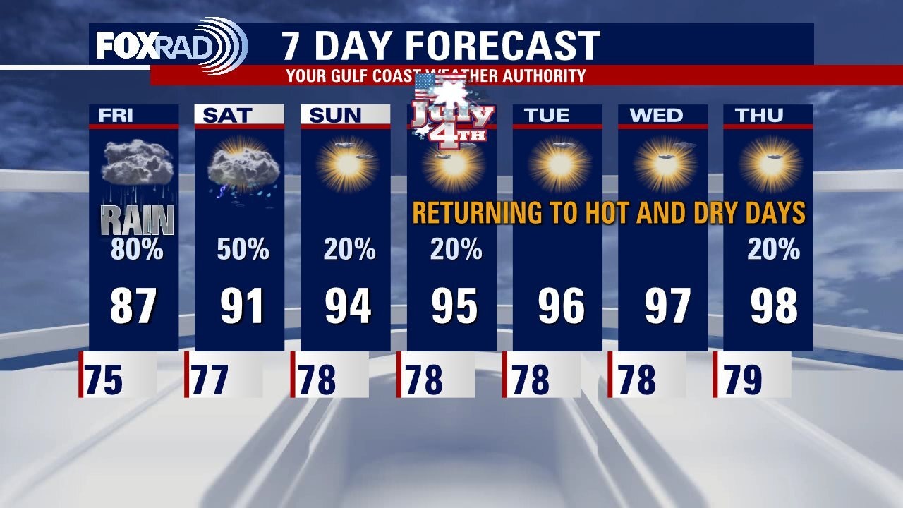
Rounds of rain, storms today & tomorrow
Scattered downpours through midday today could lead to problem spots in some areas, with a Flood Watch in effect for our coastal counties through 7 p.m. Lingering moisture brings another round of scattered showers and storms to the area tomorrow, in addition to another day of cooler temps. Warm, humid, dry weather begins to emerge on Sunday with a transition day. Things look great for the July 4th holiday and beyond!
Scattered downpours through midday today could lead to problem spots in some areas, with a Flood Watch in effect for our coastal counties through 7 p.m. Lingering moisture brings another round of scattered showers and storms to the area tomorrow, in addition to another day of cooler temps. Warm, humid, dry weather begins to emerge on Sunday with a transition day. Things look great for the July 4th holiday and beyond!
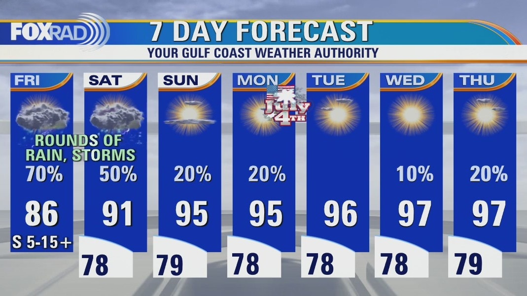
Scattered downpours on Friday
Scattered downpours through midday today could lead to problem spots in some areas, with a Flood Watch in effect for our coastal counties through 7 p.m. Lingering moisture brings another round of scattered showers and storms to the area tomorrow, in addition to another day of cooler temps. Warm, humid, dry weather begins to emerge on Sunday with a transition day. Things look great for the July 4th holiday and beyond!
Scattered downpours through midday today could lead to problem spots in some areas, with a Flood Watch in effect for our coastal counties through 7 p.m. Lingering moisture brings another round of scattered showers and storms to the area tomorrow, in addition to another day of cooler temps. Warm, humid, dry weather begins to emerge on Sunday with a transition day. Things look great for the July 4th holiday and beyond!
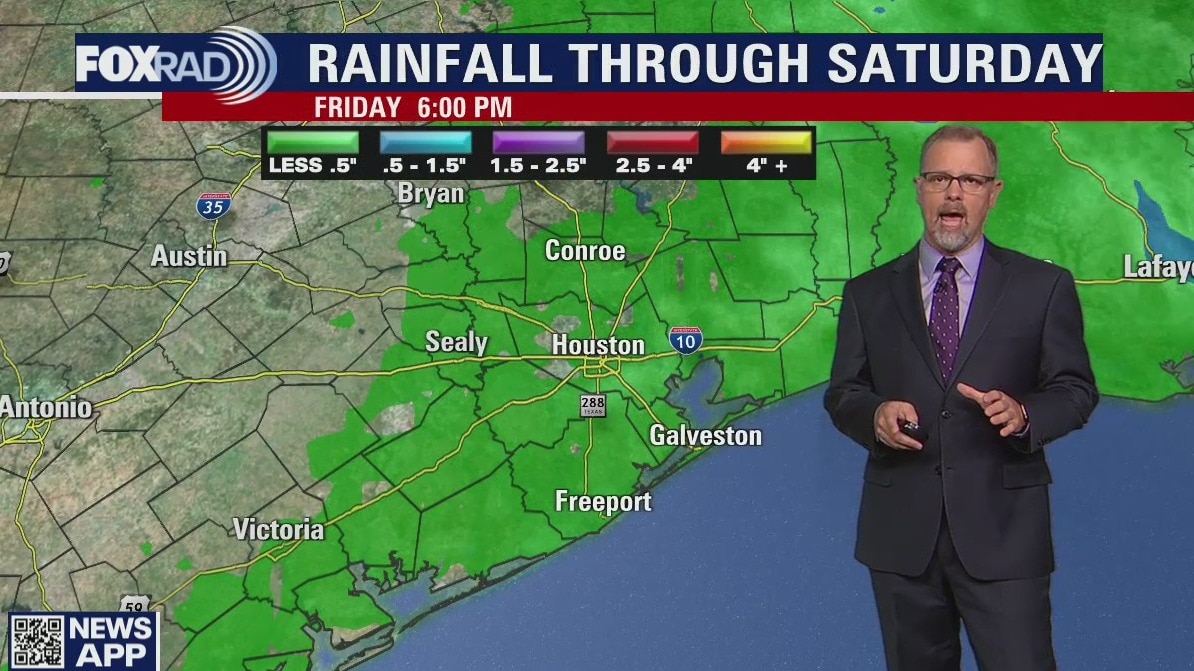
Friday morning weather forecast
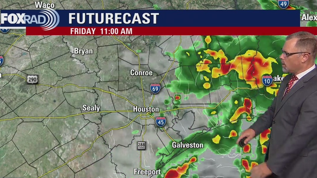
A Flood Watch through Friday is in place for counties near the coast including Harris County as we watch a Gulf low move towards Houston. Most of the rainfall is expected to stay in the Gulf but some could cause some isolated problems. Look for a few more scattered showers on Saturday and things really start to dry out for Sunday. The 4th of July look muggy and hot with an isolated afternoon shower.
A Flood Watch through Friday is in place for counties near the coast including Harris County as we watch a Gulf low move towards Houston. Most of the rainfall is expected to stay in the Gulf but some could cause some isolated problems. Look for a few more scattered showers on Saturday and things really start to dry out for Sunday. The 4th of July look muggy and hot with an isolated afternoon shower.
Thursday evening weather forecast with Meteorologist John Dawson
A Flood Watch through Friday is in place for counties near the coast including Harris County as we watch a Gulf low move towards Houston. Most of the rainfall is expected to stay in the Gulf but some could cause some isolated problems. Look for a few more scattered showers on Saturday and things really start to dry out for Sunday. The 4th of July look muggy and hot with an isolated afternoon shower.
A Flood Watch through Friday is in place for counties near the coast including Harris County as we watch a Gulf low move towards Houston. Most of the rainfall is expected to stay in the Gulf but some could cause some isolated problems. Look for a few more scattered showers on Saturday and things really start to dry out for Sunday. The 4th of July look muggy and hot with an isolated afternoon shower.