

Sunday Morning Forecast with Meteorologist Lena Maria Arango
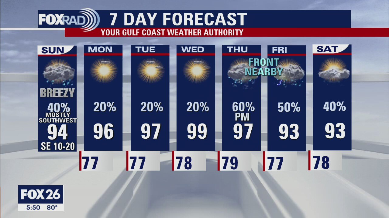
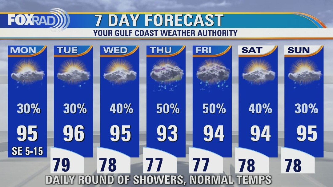
After Sunday's scattered showers, a pattern change is on the horizon through midweek. Typical August weather will linger until midday Thursday, as we watch for an approaching front to boost our rain chances once again. While it likely doesn't make it all the way to southeast Texas, it should be close enough to drive our rain chances up and our temperatures down as we close out the week.
After Sunday's scattered showers, a pattern change is on the horizon through midweek. Typical August weather will linger until midday Thursday, as we watch for an approaching front to boost our rain chances once again. While it likely doesn't make it all the way to southeast Texas, it should be close enough to drive our rain chances up and our temperatures down as we close out the week.
Saturday evening/Sunday morning forecast
One more day of above average rain chances and then more typical August weather returns for the beginning of the week.
One more day of above average rain chances and then more typical August weather returns for the beginning of the week.

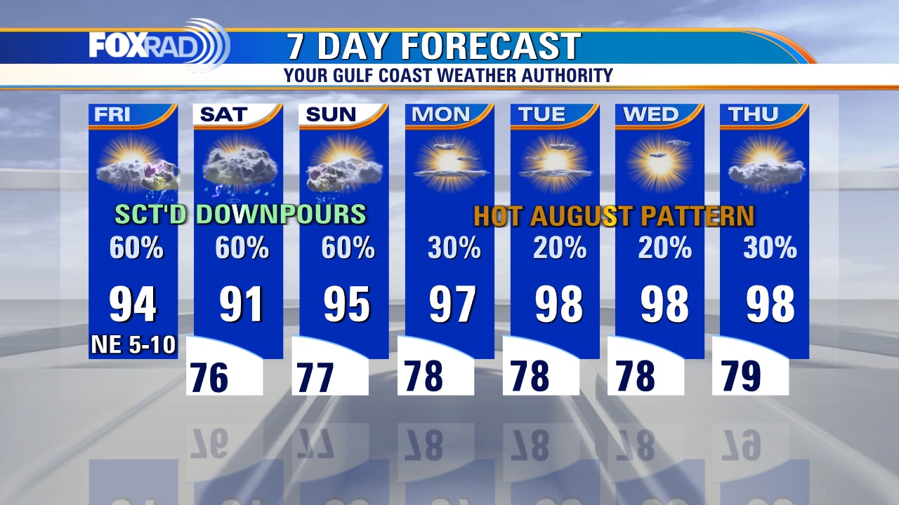
Saturday Morning Forecast with Meteorologist Lena Maria Arango
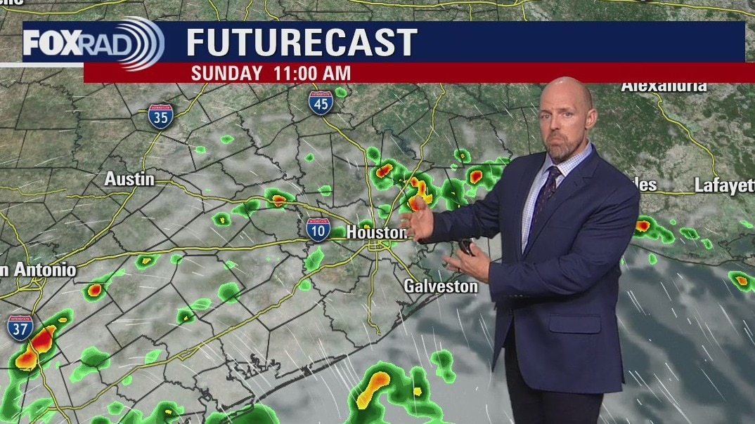
Rain along the coast Saturday morning will spread inland some this afternoon. Early Sunday morning, isolated downpours from the outer edges of Invest 98-L will begin to pop up, and linger for much of the day. I'd have a plan B for outdoor plans on Sunday, though by the evening hours we will dry out with high pressure taking over for much of next week. That will return us to the "August Norms" through midweek, with a possible approaching front bringing another dose of beneficial rain by Friday.
Rain along the coast Saturday morning will spread inland some this afternoon. Early Sunday morning, isolated downpours from the outer edges of Invest 98-L will begin to pop up, and linger for much of the day. I'd have a plan B for outdoor plans on Sunday, though by the evening hours we will dry out with high pressure taking over for much of next week. That will return us to the "August Norms" through midweek, with a possible approaching front bringing another dose of beneficial rain by Friday.
Saturday morning weather forecast
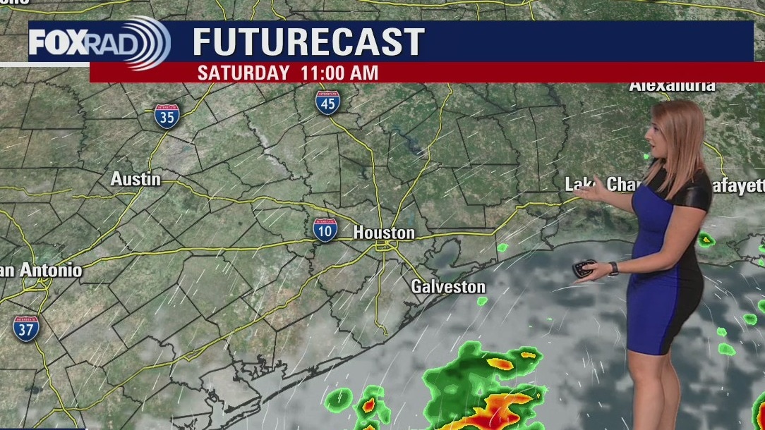
A disturbance in the Gulf of Mexico looks to bring scattered downpours to our area this weekend. While the heaviest rain will likely extend from the Coastal Bend to the Rio Grande Valley, some pockets of heavy rain are also possible across Southeast Texas. We'll trend drier and hotter as we head into next week with temperatures returning to the upper 90s.
A disturbance in the Gulf of Mexico looks to bring scattered downpours to our area this weekend. While the heaviest rain will likely extend from the Coastal Bend to the Rio Grande Valley, some pockets of heavy rain are also possible across Southeast Texas. We'll trend drier and hotter as we head into next week with temperatures returning to the upper 90s.
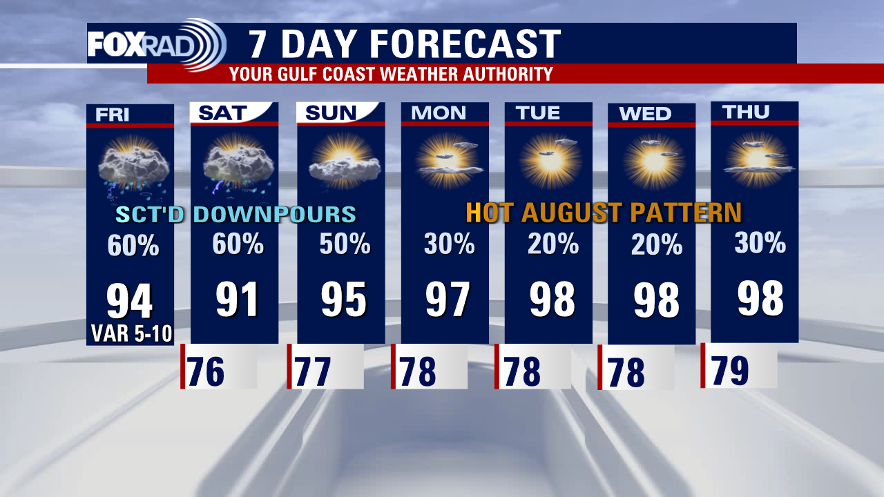
Friday evening weather forecast
A disturbance in the Gulf of Mexico looks to bring scattered downpours to our area this weekend. While the heaviest rain will likely extend from the Coastal Bend to the Rio Grande Valley, some pockets of heavy rain are also possible across Southeast Texas. We'll trend drier and hotter as we head into next week with temperatures returning to the upper 90s.
A disturbance in the Gulf of Mexico looks to bring scattered downpours to our area this weekend. While the heaviest rain will likely extend from the Coastal Bend to the Rio Grande Valley, some pockets of heavy rain are also possible across Southeast Texas. We'll trend drier and hotter as we head into next week with temperatures returning to the upper 90s.
Friday afternoon weather forecast with Meteorologist Lena Maria Arango
Tricky forecast, with lots of moving parts as we watch for possible development in the Gulf. Hurricane Hunters are set to investigate the area through multiple flights over the weekend. Rain chances remain in the forecast regardless, with pockets of heavier rainfall possible at times as the area of disturbed weather drifts westward. Plan for scattered downpours at least through Saturday, possibly spilling into Sunday with warmer, drier conditions taking over for much of next week.
Tricky forecast, with lots of moving parts as we watch for possible development in the Gulf. Hurricane Hunters are set to investigate the area through multiple flights over the weekend. Rain chances remain in the forecast regardless, with pockets of heavier rainfall possible at times as the area of disturbed weather drifts westward. Plan for scattered downpours at least through Saturday, possibly spilling into Sunday with warmer, drier conditions taking over for much of next week.
Friday morning weather forecast with Chief Meteorologist Mike Iscovitz
Our pattern remains unsettled for today, tomorrow, and probably Sunday. Our atmosphere is very humid, so it doesn't take much to spark thunderstorms. In addition, storms that do form could each drop about 2" of rain. Areas away from rain will remain steamy with highs in the low to mid-90s. Finally, we will watch the Gulf this weekend as there is a slight chance for a small tropical low to form and likely pass to our south.
Our pattern remains unsettled for today, tomorrow, and probably Sunday. Our atmosphere is very humid, so it doesn't take much to spark thunderstorms. In addition, storms that do form could each drop about 2" of rain. Areas away from rain will remain steamy with highs in the low to mid-90s. Finally, we will watch the Gulf this weekend as there is a slight chance for a small tropical low to form and likely pass to our south.

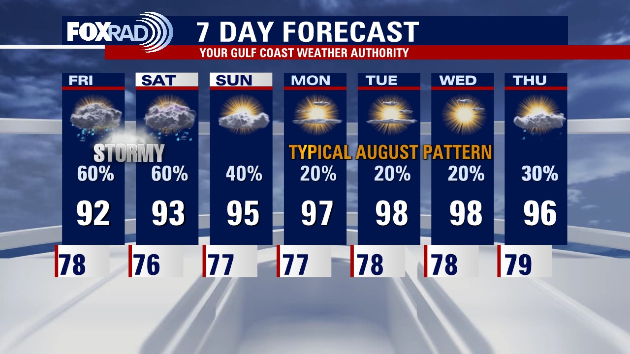
Thursday night leading into Friday morning weather forecast
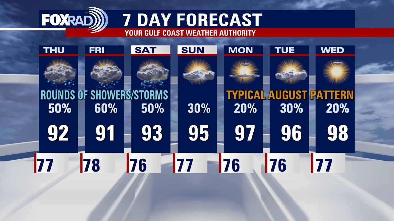
We are wrapping up the week tomorrow with more unsettled weather. Some of the rain could be heavy at times. With rain and added clouds around, temperatures will stay down. Highs will just top out into the low 90s. A more typical August pattern will resume heading into next week with the heat returning, more sunshine, and just isolated storm chances.
We are wrapping up the week tomorrow with more unsettled weather. Some of the rain could be heavy at times. With rain and added clouds around, temperatures will stay down. Highs will just top out into the low 90s. A more typical August pattern will resume heading into next week with the heat returning, more sunshine, and just isolated storm chances.
Thursday evening weather forecast with Meteorologist Adrienne Vonn
We are wrapping up the week tomorrow with more unsettled weather. Some of the rain could be heavy at times. With rain and added clouds around, temperatures will stay down. Highs will just top out into the low 90s. A more typical August pattern will resume heading into next week with the heat returning, more sunshine and just isolated storm chances.
We are wrapping up the week tomorrow with more unsettled weather. Some of the rain could be heavy at times. With rain and added clouds around, temperatures will stay down. Highs will just top out into the low 90s. A more typical August pattern will resume heading into next week with the heat returning, more sunshine and just isolated storm chances.
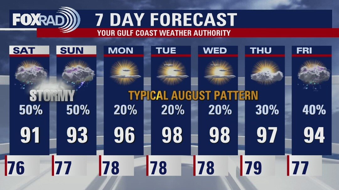
Daily scattered storms, some heavy rainfall possible through Saturday
Pockets of heavy rainfall remain possible through Saturday, with scattered daily storms remaining in the forecast. Models are hinting at the possibility of a weak area of low pressure forming in the Gulf due to all of this agitation. Don't expect anything robust, but it could boost rain chances heading into the weekend. Sunday we'll transition to warmer and drier conditions as an area of high pressure begins to take over, which will return us to our "Regularly Scheduled August Programming" for much of next week. The tropical wave we had been watching way out in the Atlantic ceases to exist, with dry air/dust/shear winning that battle. We have now gone nearly 40 days without a named system in the tropical Atlantic.
Pockets of heavy rainfall remain possible through Saturday, with scattered daily storms remaining in the forecast. Models are hinting at the possibility of a weak area of low pressure forming in the Gulf due to all of this agitation. Don't expect anything robust, but it could boost rain chances heading into the weekend. Sunday we'll transition to warmer and drier conditions as an area of high pressure begins to take over, which will return us to our "Regularly Scheduled August Programming" for much of next week. The tropical wave we had been watching way out in the Atlantic ceases to exist, with dry air/dust/shear winning that battle. We have now gone nearly 40 days without a named system in the tropical Atlantic.

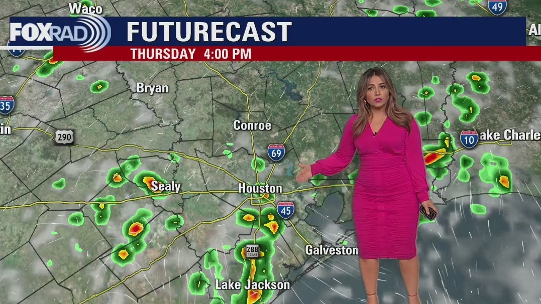
Mostly cloudy with scattered afternoon and evening storms
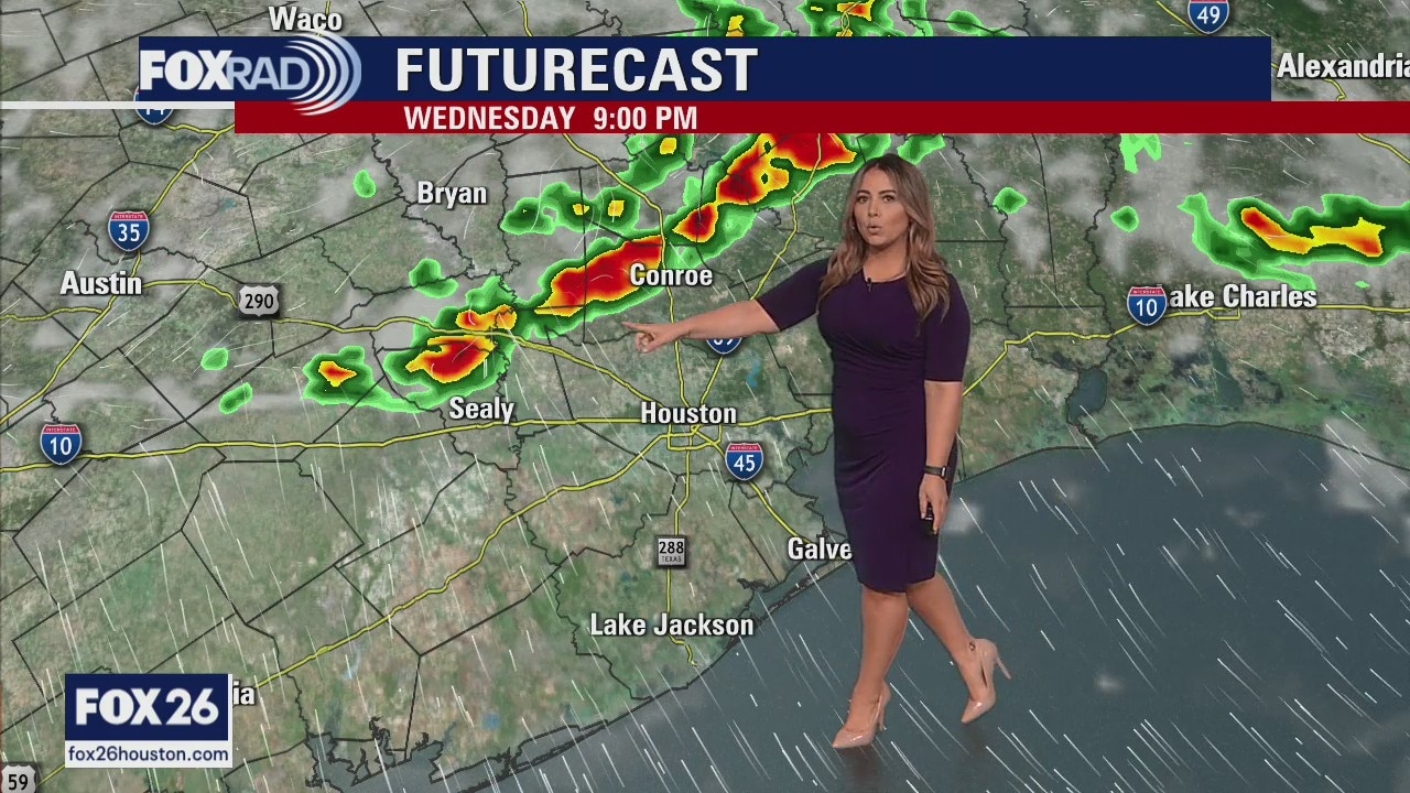
Following yesterday's downpours, which was the heaviest rain at Bush IAH since January 9th, today should produce another round of rain. The highest likelihood for heavy rain is south of Houston today. More scattered heavy storms are possible Friday and Saturday with hotter, less active weather beginning Sunday. Isolated rainfall of 3-4" or more is possible with a more common 1-2" expected over the next three days. Also, there is a small chance (what I would call a non-zero chance) for a short-lived tropical system along the Texas coastline Friday/Saturday. NOT likely, but a small chance I thought I would throw out there.
Following yesterday's downpours, which was the heaviest rain at Bush IAH since January 9th, today should produce another round of rain. The highest likelihood for heavy rain is south of Houston today. More scattered heavy storms are possible Friday and Saturday with hotter, less active weather beginning Sunday. Isolated rainfall of 3-4" or more is possible with a more common 1-2" expected over the next three days. Also, there is a small chance (what I would call a non-zero chance) for a short-lived tropical system along the Texas coastline Friday/Saturday. NOT likely, but a small chance I thought I would throw out there.
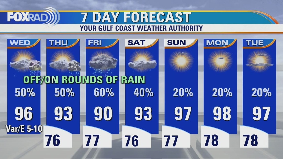
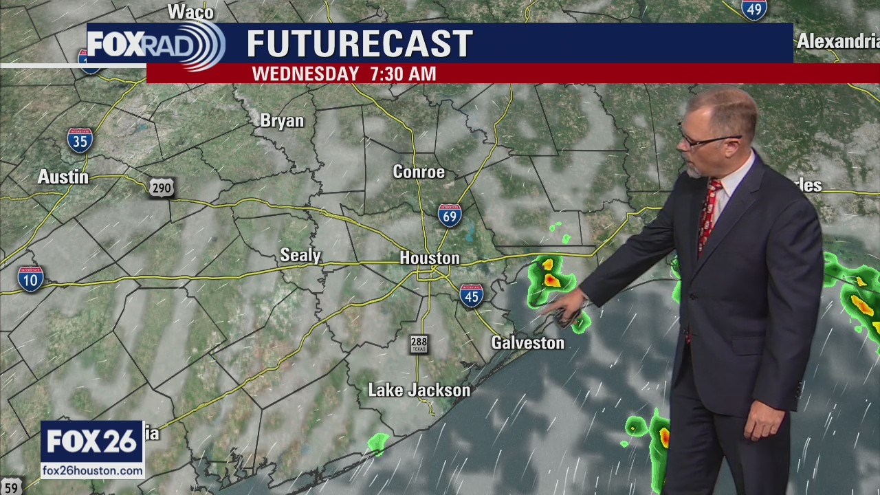
Wednesday night leading into Thursday morning weather forecast
Houston will end the week with higher rain chances in the forecast and slightly cooler temperatures. Most of Southeast Texas will see 1-2 inches of rain Thursday through Saturday but isolated areas could see 2-4 inches. Back to the normal August heat and isolated afternoon showers for the start of next week.
Houston will end the week with higher rain chances in the forecast and slightly cooler temperatures. Most of Southeast Texas will see 1-2 inches of rain Thursday through Saturday but isolated areas could see 2-4 inches. Back to the normal August heat and isolated afternoon showers for the start of next week.
Get ready for some rain
Several days of unsettled weather will bring multiple rounds of helpful rainfall to southeast Texas. Pockets of locally heavy rain may lead to isolated problem spots at times. Cooler temperatures linger through the start of the weekend, with a drier warmer pattern carrying us into the start of next week. The tropical wave we've been watching in the Atlantic is struggling to form under unfavorable conditions.
Several days of unsettled weather will bring multiple rounds of helpful rainfall to southeast Texas. Pockets of locally heavy rain may lead to isolated problem spots at times. Cooler temperatures linger through the start of the weekend, with a drier warmer pattern carrying us into the start of next week. The tropical wave we've been watching in the Atlantic is struggling to form under unfavorable conditions.
Warm and humid; scattered storms expected this afternoon and tonight
We are entering an unsettled pattern over the next four days with a daily round of storms and even the chance for a few of them to be locally heavy. Expect warm, very humid air with storms possible both in the afternoon, but at times even overnight. Total rainfall through Saturday could exceed 3" in spots, so that is very helpful to our ongoing drought. The tropical wave we're watching in the Atlantic Ocean has not organized and looks disorganized today.
We are entering an unsettled pattern over the next four days with a daily round of storms and even the chance for a few of them to be locally heavy. Expect warm, very humid air with storms possible both in the afternoon, but at times even overnight. Total rainfall through Saturday could exceed 3" in spots, so that is very helpful to our ongoing drought. The tropical wave we're watching in the Atlantic Ocean has not organized and looks disorganized today.
Wetter, cooler weather thru rest of week
The warm and dry pattern changes for Houston on Wednesday with increased rain chances. That wetter and slightly cooler patterns stays the through the rest of the week. Southeast Texas still needs lots of rain to help with the strong drought conditions in place. The weekend looks to be back to "normal" August in Houston.
The warm and dry pattern changes for Houston on Wednesday with increased rain chances. That wetter and slightly cooler patterns stays the through the rest of the week. Southeast Texas still needs lots of rain to help with the strong drought conditions in place. The weekend looks to be back to "normal" August in Houston.

Wetter, cooler Wednesday ahead
The warm and dry pattern changes for Houston on Wednesday with increased rain chances. That wetter and slightly cooler patterns stay through the rest of the week. Southeast Texas still needs lots of rain to help with the strong drought conditions in place. The weekend looks to be back to "normal" August in Houston.
The warm and dry pattern changes for Houston on Wednesday with increased rain chances. That wetter and slightly cooler patterns stay through the rest of the week. Southeast Texas still needs lots of rain to help with the strong drought conditions in place. The weekend looks to be back to "normal" August in Houston.
Partly cloudy, hot and humid Tuesday with isolated late day storms
Fortunately, we are entering a pattern which includes a daily round of rain, especially tomorrow through Friday. Expect a hot and humid day today with hit and miss midday and afternoon storms. The rest of the week brings the potential for more widespread rain which should help with our drought. There is one tropical wave in the far eastern Atlantic that is not a threat to our area.
Fortunately, we are entering a pattern which includes a daily round of rain, especially tomorrow through Friday. Expect a hot and humid day today with hit and miss midday and afternoon storms. The rest of the week brings the potential for more widespread rain which should help with our drought. There is one tropical wave in the far eastern Atlantic that is not a threat to our area.
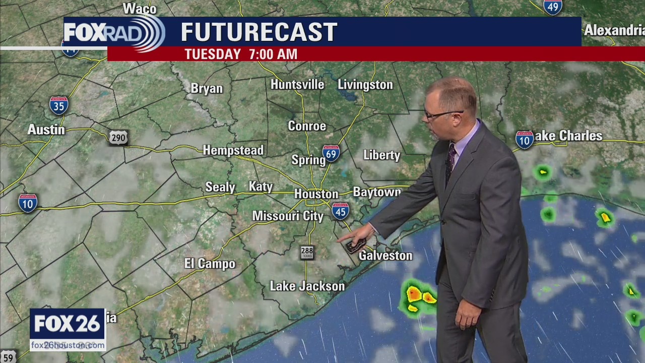
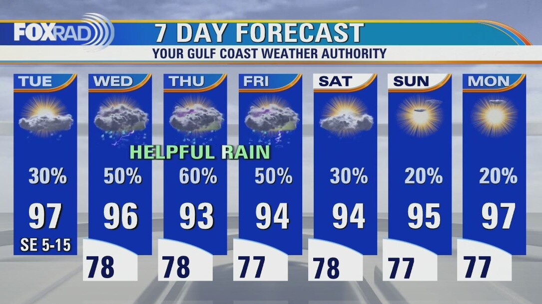
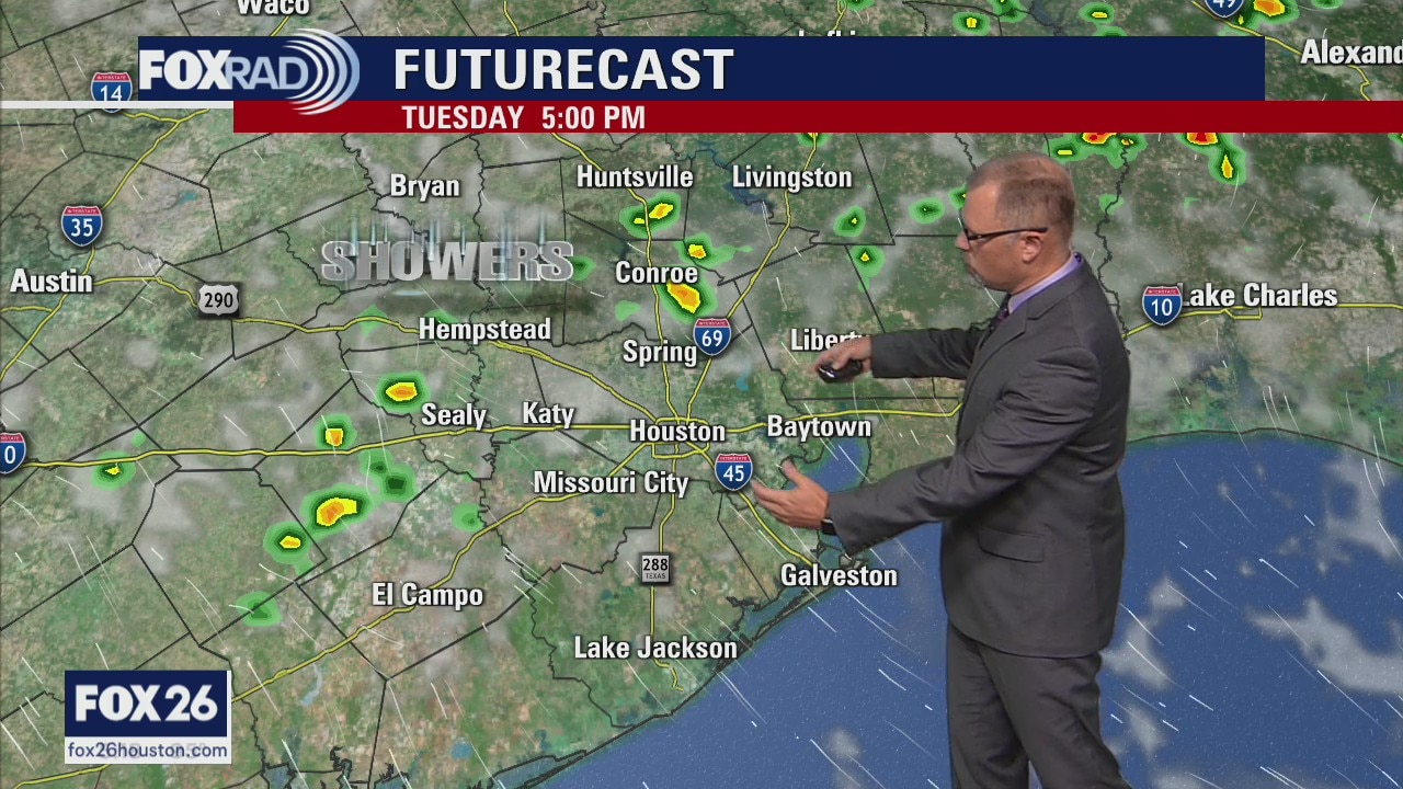
August heat cranks up Tuesday
The August heat cranks up for Tuesday across Houston. Plan for afternoon highs to be near the triple digits around Southeast Texas. The pattern then shifts on Wednesday to more clouds with higher rain chances. Look for those daily rain chances to continue into the weekend. There is a tropical wave in the Atlantic, check out our YouTube Channel for the latest.
The August heat cranks up for Tuesday across Houston. Plan for afternoon highs to be near the triple digits around Southeast Texas. The pattern then shifts on Wednesday to more clouds with higher rain chances. Look for those daily rain chances to continue into the weekend. There is a tropical wave in the Atlantic, check out our YouTube Channel for the latest.
August heat cranks up on Tuesday
The August heat cranks up for Tuesday across Houston. Plan for afternoon highs to be near the triple digits around Southeast Texas. The pattern then shifts on Wednesday to more clouds with higher rain chances. Look for those daily rain chances to continue into the weekend. There is a tropical wave in the Atlantic, check out our YouTube Channel for the latest.
The August heat cranks up for Tuesday across Houston. Plan for afternoon highs to be near the triple digits around Southeast Texas. The pattern then shifts on Wednesday to more clouds with higher rain chances. Look for those daily rain chances to continue into the weekend. There is a tropical wave in the Atlantic, check out our YouTube Channel for the latest.
Partly cloudy and warm with isolated late day storms possible
How does a daily round of rain sound? We really need it, not just in the Houston area, but across the state. A pattern change is taking place with the infamous "heat dome" of high pressure going away for now which allows for a more "normal" pattern. Expect highs in the mid 90s (some upper 90s) and scattered showers and storms mainly in the afternoon. In the tropics, a healthy wave is located many thousands of miles away near the west coast of Africa, but has a good chance of becoming a depression or tropical storm this week. No threat to our area.
How does a daily round of rain sound? We really need it, not just in the Houston area, but across the state. A pattern change is taking place with the infamous "heat dome" of high pressure going away for now which allows for a more "normal" pattern. Expect highs in the mid 90s (some upper 90s) and scattered showers and storms mainly in the afternoon. In the tropics, a healthy wave is located many thousands of miles away near the west coast of Africa, but has a good chance of becoming a depression or tropical storm this week. No threat to our area.