

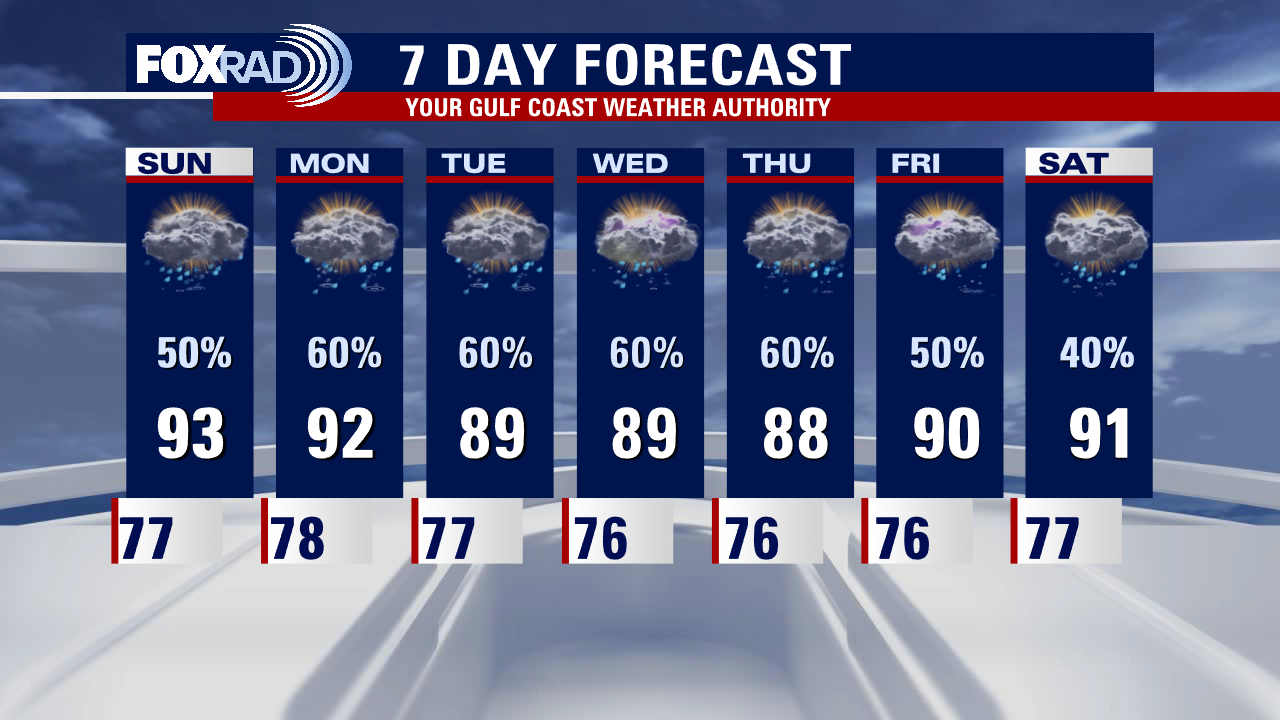
Saturday night leading into Sunday morning weather forecast
Grab the umbrellas! A slow-moving boundary is set to bring several opportunities for rain and thunderstorms as we head into next week. Some of the rain could be heavy at times and localized flooding will be possible. Not only will the rain help with ongoing drought conditions across the area, but it'll also help keep our temperatures down. Highs will largely be in the upper 80s and low 90s through the next several days.
Grab the umbrellas! A slow-moving boundary is set to bring several opportunities for rain and thunderstorms as we head into next week. Some of the rain could be heavy at times and localized flooding will be possible. Not only will the rain help with ongoing drought conditions across the area, but it'll also help keep our temperatures down. Highs will largely be in the upper 80s and low 90s through the next several days.

Saturday Morning Forecast with Meteorologist Lena Maria Arango
The 7-day features a fairly soggy pattern, with scattered showers and storms that may be heavy at times. Daily rains should lead to a sizable dent in the drought monitor by next Thursday, and keep our daytime highs considerably below average. While there is plenty of moisture around, most of it is not tropical in nature. Potential Tropical Cyclone 4 will pass well to our south this weekend, with a new wave emerging off the coast of Africa that may gradually develop as it tracks west-northwest. No threats are anticipated for Southeast Texas from either system at this time.
The 7-day features a fairly soggy pattern, with scattered showers and storms that may be heavy at times. Daily rains should lead to a sizable dent in the drought monitor by next Thursday, and keep our daytime highs considerably below average. While there is plenty of moisture around, most of it is not tropical in nature. Potential Tropical Cyclone 4 will pass well to our south this weekend, with a new wave emerging off the coast of Africa that may gradually develop as it tracks west-northwest. No threats are anticipated for Southeast Texas from either system at this time.
Saturday morning weather forecast
Unsettled weather is set to continue thru the weekend. While it won't be a complete washout, scattered showers and storms will be possible both Saturday and Sunday. This active pattern looks to stay in place thru next week, with rounds of rain and storms each day. With added clouds and rain, temperatures will be kept down, as high temps will just climb into the upper 80s.
Unsettled weather is set to continue thru the weekend. While it won't be a complete washout, scattered showers and storms will be possible both Saturday and Sunday. This active pattern looks to stay in place thru next week, with rounds of rain and storms each day. With added clouds and rain, temperatures will be kept down, as high temps will just climb into the upper 80s.

Friday evening weather forecast with Meteorologist Adrienne Vonn
Unsettled weather is set to continue thru the weekend. While it won't be a complete washout, scattered showers and storms will be possible both Saturday and Sunday. This active pattern looks to stay in place thru next week, with rounds of rain and storms each day. With added clouds and rain, temperatures will be kept down, as high temps will just climb into the upper 80s.
Unsettled weather is set to continue thru the weekend. While it won't be a complete washout, scattered showers and storms will be possible both Saturday and Sunday. This active pattern looks to stay in place thru next week, with rounds of rain and storms each day. With added clouds and rain, temperatures will be kept down, as high temps will just climb into the upper 80s.
Friday afternoon weather forecast with Chief Meteorologist Mike Iscovitz
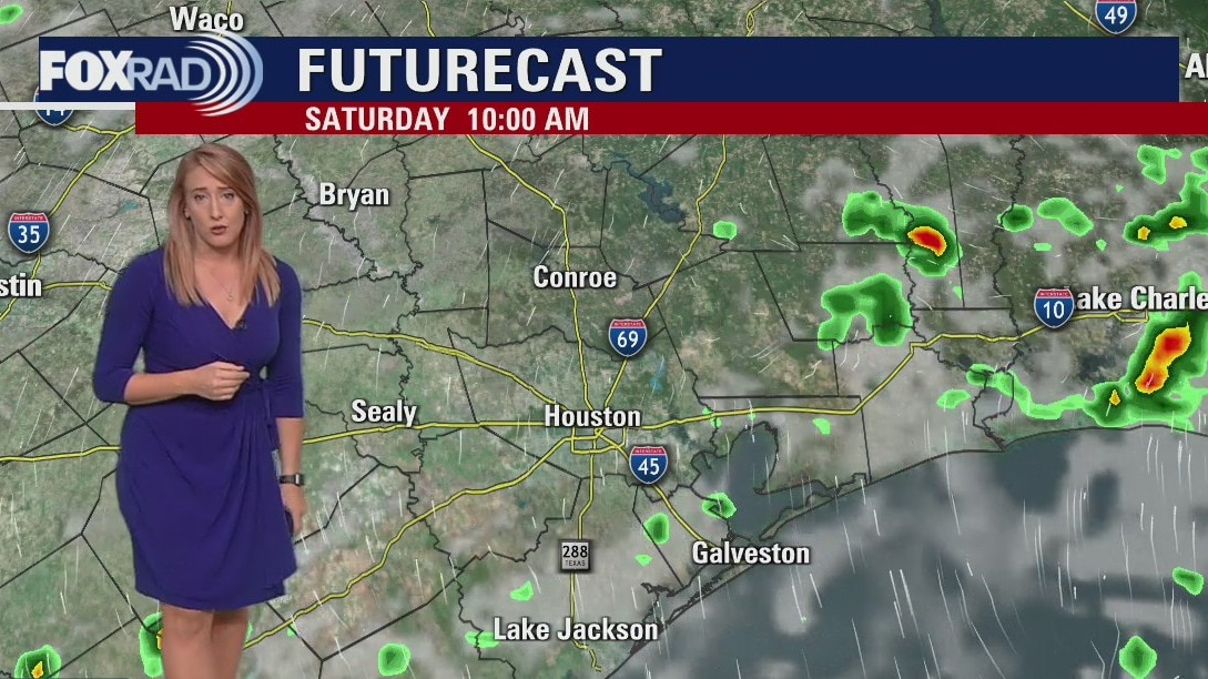
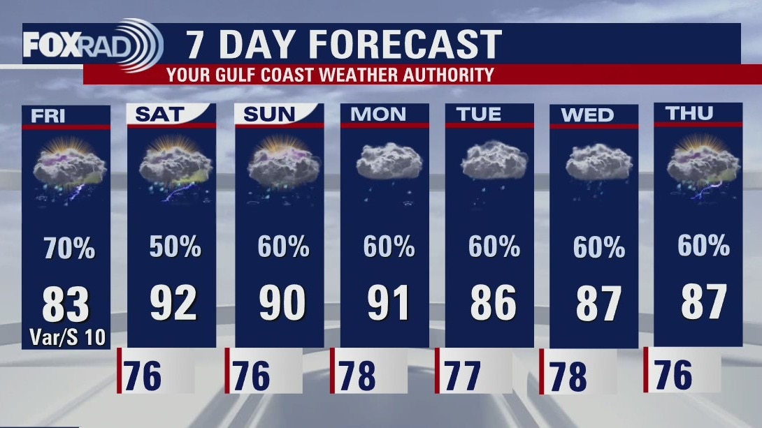
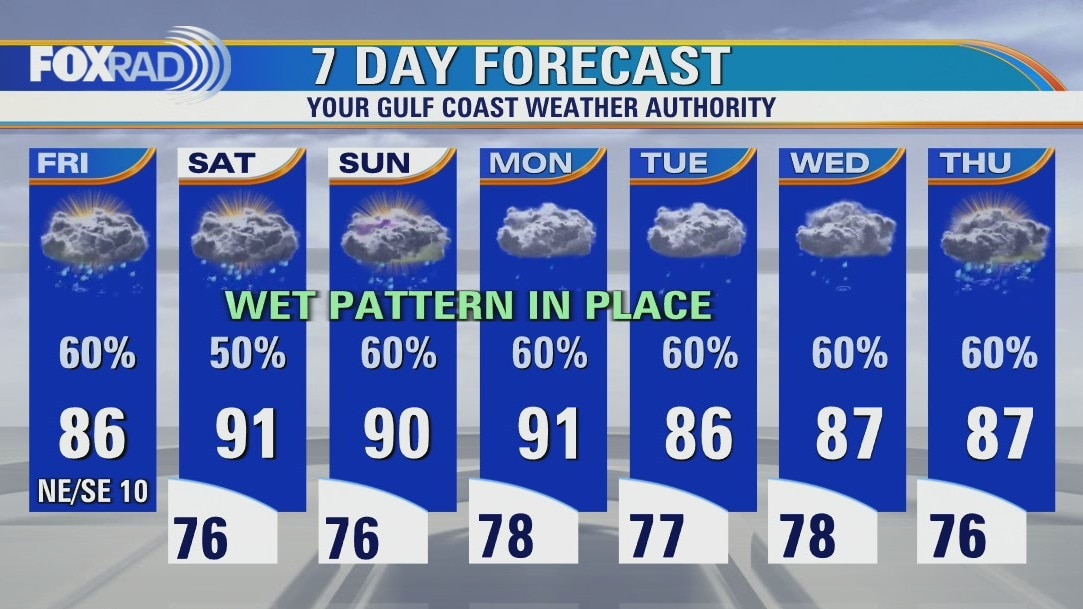
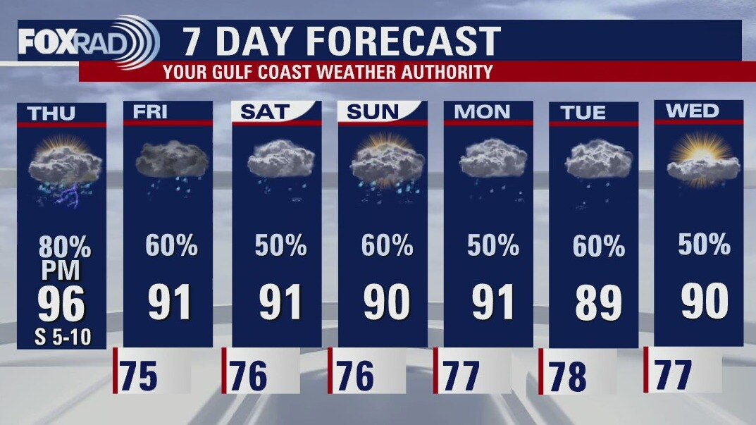
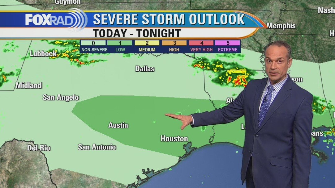
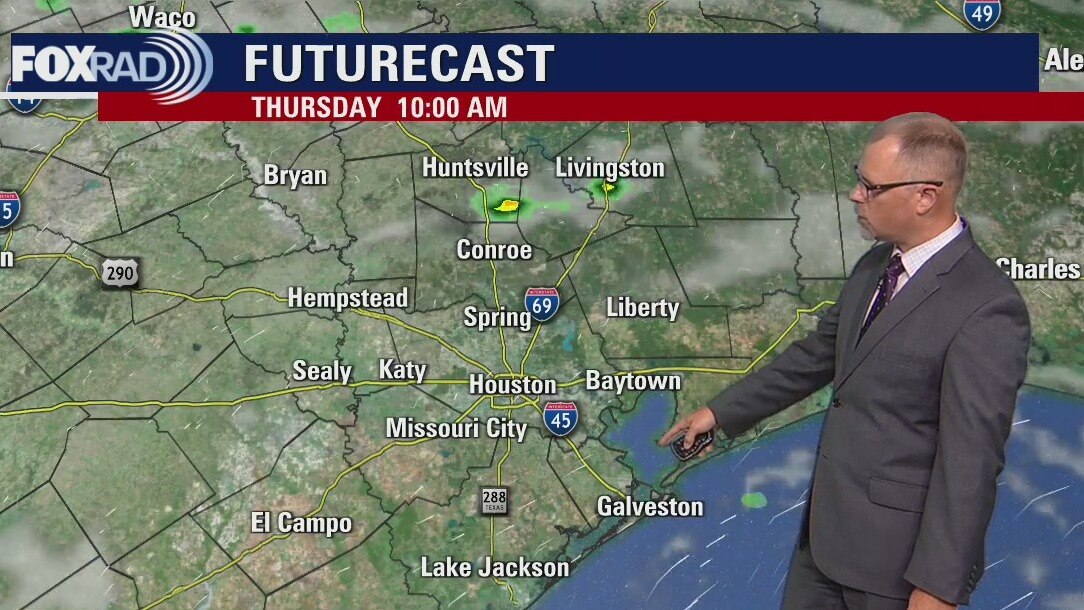
Lots to talk about with today's forecast and with an active pattern in the extended rainfall outlook. For today, another round of heavy rain appears likely. Due to yesterday's widespread 2-4" of rain, the ground is saturated, so flooding could occur more easily as heavy storms pop up. Look for isolated heavy downpours in the morning with more widespread activity from late morning through early afternoon. localized amounts of 3" will be possible again with some high winds and, once again, lots of lightning. For the weekend, expect off-and-on showers and storms as we watch the progress of what should be a small area of low pressure in the southern Gulf. The extended outlook still looks active with several rounds of drought-busting rain across Texas.
Lots to talk about with today's forecast and with an active pattern in the extended rainfall outlook. For today, another round of heavy rain appears likely. Due to yesterday's widespread 2-4" of rain, the ground is saturated, so flooding could occur more easily as heavy storms pop up. Look for isolated heavy downpours in the morning with more widespread activity from late morning through early afternoon. localized amounts of 3" will be possible again with some high winds and, once again, lots of lightning. For the weekend, expect off-and-on showers and storms as we watch the progress of what should be a small area of low pressure in the southern Gulf. The extended outlook still looks active with several rounds of drought-busting rain across Texas.
Morning coastal showers possible; scattered afternoon storms
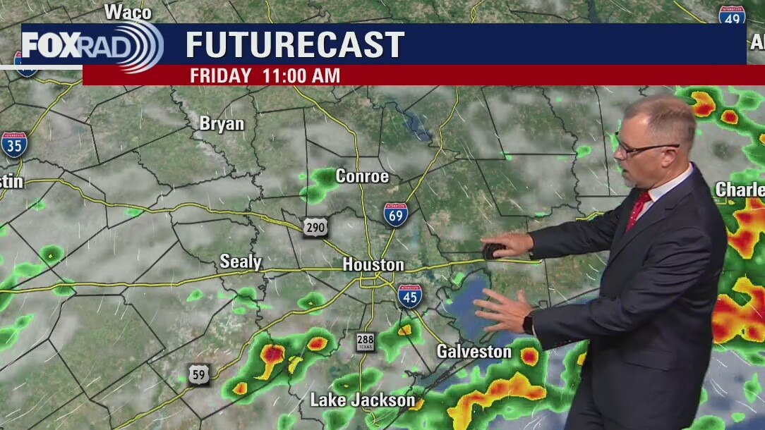
Lots to talk about with today's forecast and with an active pattern in the extended rainfall outlook. For today, another round of heavy rain appears likely. Due to yesterday's widespread 2-4" of rain, the ground is saturated, so flooding could occur more easily as heavy storms pop up. Look for isolated heavy downpours in the morning with more widespread activity from late morning through early afternoon. Localized amounts of 3" will be possible again with some high winds and, once again, lots of lightning. For the weekend, expect off and on showers and storms as we watch the progress of what should be a small area of low pressure in the southern Gulf. The extended outlook still looks active with several rounds of drought-busting rain across Texas.
Lots to talk about with today's forecast and with an active pattern in the extended rainfall outlook. For today, another round of heavy rain appears likely. Due to yesterday's widespread 2-4" of rain, the ground is saturated, so flooding could occur more easily as heavy storms pop up. Look for isolated heavy downpours in the morning with more widespread activity from late morning through early afternoon. Localized amounts of 3" will be possible again with some high winds and, once again, lots of lightning. For the weekend, expect off and on showers and storms as we watch the progress of what should be a small area of low pressure in the southern Gulf. The extended outlook still looks active with several rounds of drought-busting rain across Texas.
Friday morning weather forecast
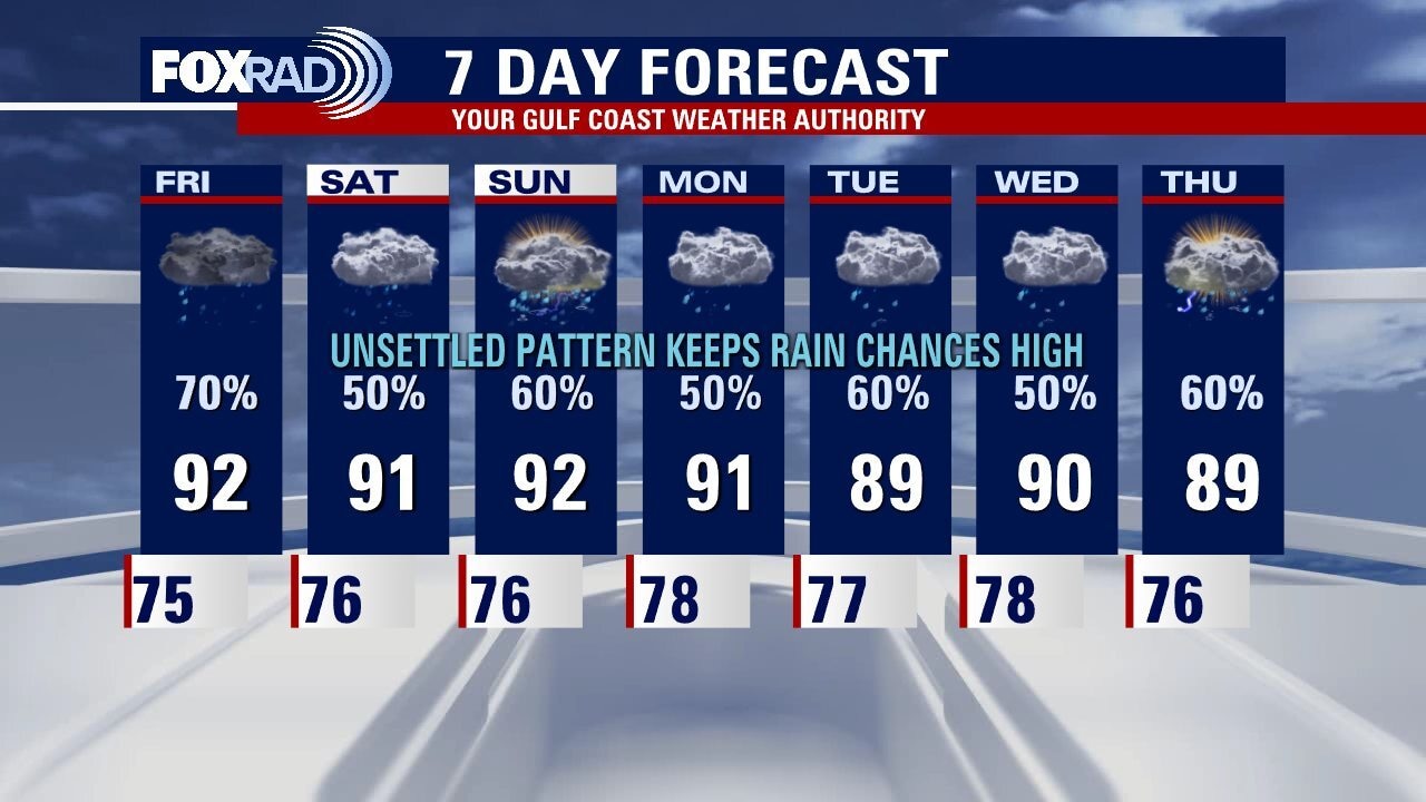
This is one of those rare times where I think very few people will be upset by a 7 Day forecast with this much rain. Southeast Texas has been so dry this summer we really need the rain! Houston will see at least a 50% chance of rain every day for the next week.
This is one of those rare times where I think very few people will be upset by a 7 Day forecast with this much rain. Southeast Texas has been so dry this summer we really need the rain! Houston will see at least a 50% chance of rain every day for the next week.
Thursday evening weather forecast with Meteorologist John Dawson
This is one of those rare times where I think very few people will be upset by a 7 Day forecast with this much rain. Southeast Texas has been so dry this summer we really need the rain! Houston will see at least a 50% chance of rain every day for the next week.
This is one of those rare times where I think very few people will be upset by a 7 Day forecast with this much rain. Southeast Texas has been so dry this summer we really need the rain! Houston will see at least a 50% chance of rain every day for the next week.
Thursday afternoon weather forecast
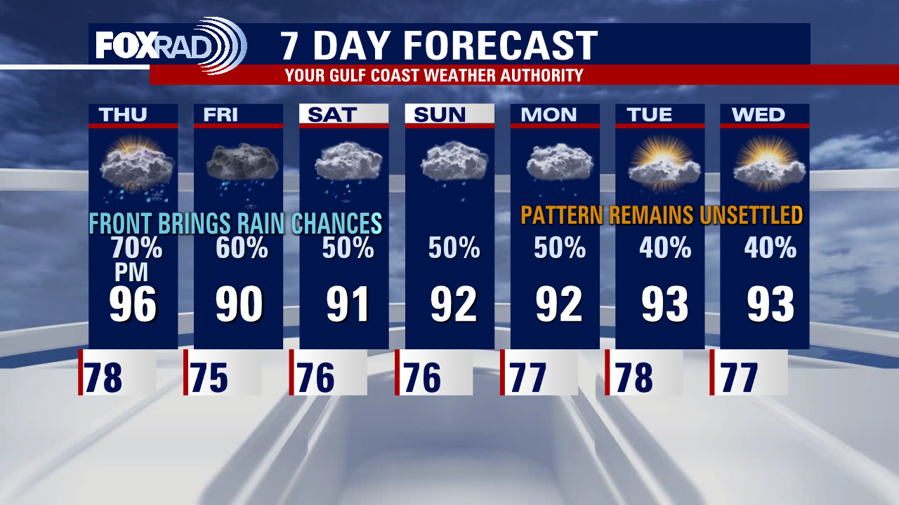
We are about to enter an unsettled weather pattern that will include a good chance for rain each day for at least a week. Most of today will be very hot and humid, but strong storms are expected by late afternoon and evening that could drop 2-3" of rain (or more) along with lots of lightning. The extended forecast includes daily showers and below-average temperatures.
We are about to enter an unsettled weather pattern that will include a good chance for rain each day for at least a week. Most of today will be very hot and humid, but strong storms are expected by late afternoon and evening that could drop 2-3" of rain (or more) along with lots of lightning. The extended forecast includes daily showers and below-average temperatures.
Line of afternoon or evening storms likely, some strong
We are about to enter an unsettled weather pattern that will include a good chance for rain each day for at least a week. Most of today will be very hot and humid, but strong storms are expected by late afternoon and evening that could drop 2-3" of rain (or more) along with lots of lightning. The extended forecast includes daily showers and below average temperatures.
We are about to enter an unsettled weather pattern that will include a good chance for rain each day for at least a week. Most of today will be very hot and humid, but strong storms are expected by late afternoon and evening that could drop 2-3" of rain (or more) along with lots of lightning. The extended forecast includes daily showers and below average temperatures.
Thursday morning weather forecast
The 7 Day forecast for Houston does not look quite as "August" as it has for most of this month. A sagging front on Thursday starts a unsettled pattern that includes plenty of chances for rain plus temperatures below the seasonal averages. We are still watching a tropical wave headed towards the southern Gulf of Mexico. Click over to the FOX26 YouTube channel for the latest.
The 7 Day forecast for Houston does not look quite as "August" as it has for most of this month. A sagging front on Thursday starts a unsettled pattern that includes plenty of chances for rain plus temperatures below the seasonal averages. We are still watching a tropical wave headed towards the southern Gulf of Mexico. Click over to the FOX26 YouTube channel for the latest.
Wednesday evening weather forecast with Meteorologist John Dawson
The 7 Day forecast for Houston does not look quite as "August" as it has for most of this month. A sagging front on Thursday starts an unsettled pattern that includes plenty of chances for rain plus temperatures below the seasonal averages. We are still watching a tropical wave headed towards the southern Gulf of Mexico. Click over to the FOX26 YouTube channel for the latest.
The 7 Day forecast for Houston does not look quite as "August" as it has for most of this month. A sagging front on Thursday starts an unsettled pattern that includes plenty of chances for rain plus temperatures below the seasonal averages. We are still watching a tropical wave headed towards the southern Gulf of Mexico. Click over to the FOX26 YouTube channel for the latest.
Mostly sunny and hot with highs near 100; chance for evening or overnight rain
Following a very hot back to school day for thousands of local students, we will enter several days with an unsettled weather pattern. A series of upper level disturbances will move through Texas and should allow for waves of rainfall to help ease the drought and hold temperatures to below normal late this week, through the weekend and for much of next week. In the tropics, a wave near the Yucatan could contribute to rain along the Texas coastline this weekend.
Following a very hot back to school day for thousands of local students, we will enter several days with an unsettled weather pattern. A series of upper level disturbances will move through Texas and should allow for waves of rainfall to help ease the drought and hold temperatures to below normal late this week, through the weekend and for much of next week. In the tropics, a wave near the Yucatan could contribute to rain along the Texas coastline this weekend.
Wednesday morning weather forecast
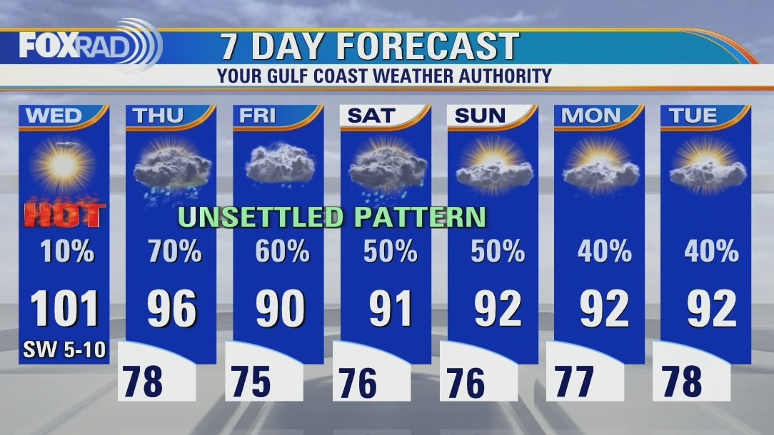
Another very hot day for Houston on Wednesday. The afternoon heat will push close to 100 again on Thursday, but some late day showers will start a pattern change that includes higher rain chances and slightly lower temperatures for Southeast Texas going into the weekend.
Another very hot day for Houston on Wednesday. The afternoon heat will push close to 100 again on Thursday, but some late day showers will start a pattern change that includes higher rain chances and slightly lower temperatures for Southeast Texas going into the weekend.
Tuesday evening weather forecast
Another very hot day for Houston on Wednesday. The afternoon heat will push close to 100 again on Thursday, but some late day showers will start a pattern change that includes higher rain chances and slightly lower temperatures for Southeast Texas going into the weekend.
Another very hot day for Houston on Wednesday. The afternoon heat will push close to 100 again on Thursday, but some late day showers will start a pattern change that includes higher rain chances and slightly lower temperatures for Southeast Texas going into the weekend.
More rain on the way
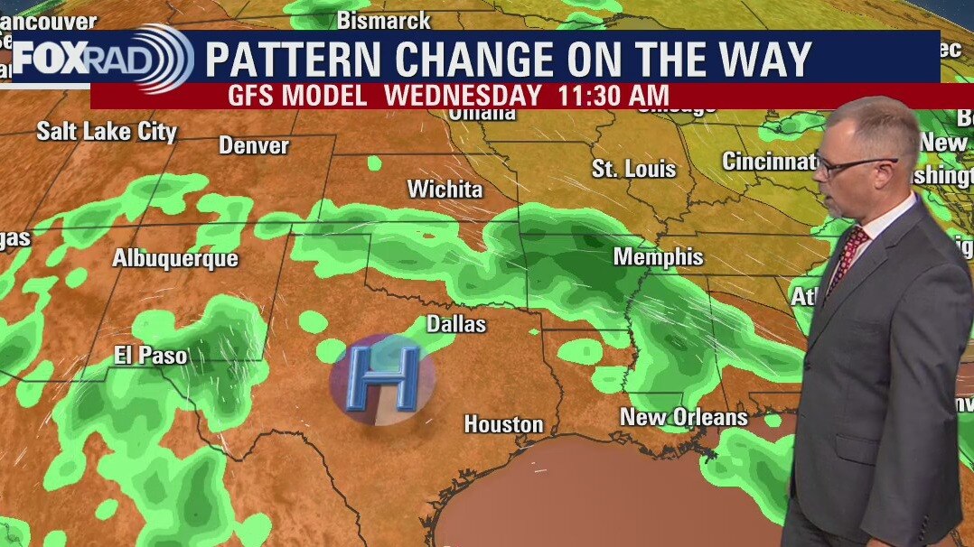
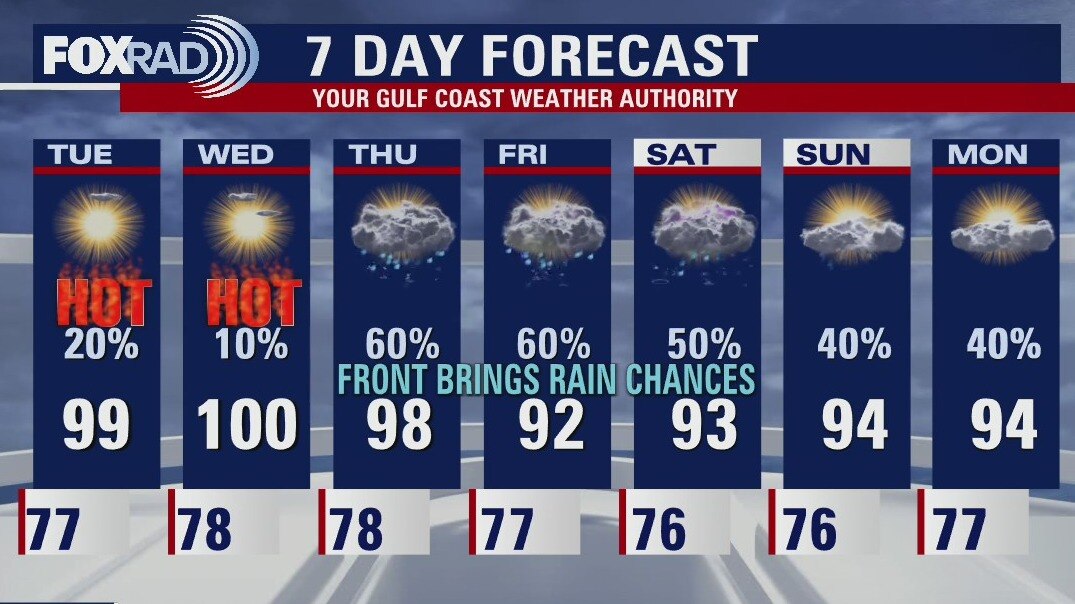
More rain is on the way, but most areas will have to wait until Thursday through Saturday with high heat in the meantime. Look for highs in the upper 90s today and low 100s Wednesday. Storms could approach as early as Wednesday night with a front sagging down from the north. The front will likely stall near our area bringing a good chance for showers Thursday, Friday, and Saturday. In the tropics, there is a healthy tropical wave that will move into Central America today that could make it into the southern Gulf this weekend. Right now, the National Hurricane Center gives it a 20% chance for development.
More rain is on the way, but most areas will have to wait until Thursday through Saturday with high heat in the meantime. Look for highs in the upper 90s today and low 100s Wednesday. Storms could approach as early as Wednesday night with a front sagging down from the north. The front will likely stall near our area bringing a good chance for showers Thursday, Friday, and Saturday. In the tropics, there is a healthy tropical wave that will move into Central America today that could make it into the southern Gulf this weekend. Right now, the National Hurricane Center gives it a 20% chance for development.
Tuesday morning weather forecast
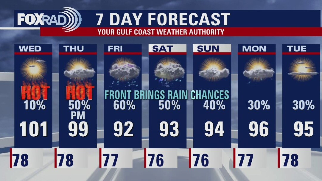
Houston will be near 100? again for the next couple of days. Thursday will also be hot but the rain chances start to increase at the end of the day as a weak cold front crawls into Southeast Texas and stalls. This front lingers around into the weekend keeping scattered showers possible through the rest of the 7 Day Forecast.
Houston will be near 100? again for the next couple of days. Thursday will also be hot but the rain chances start to increase at the end of the day as a weak cold front crawls into Southeast Texas and stalls. This front lingers around into the weekend keeping scattered showers possible through the rest of the 7 Day Forecast.
Monday evening weather forecast
Houston will be near 100° again for the next couple of days. Thursday will also be hot but the rain chances start to increase at the end of the day as a weak cold front crawls into Southeast Texas and stalls. This front lingers around into the weekend keeping scattered showers possible through the rest of the 7 Day Forecast.
Houston will be near 100° again for the next couple of days. Thursday will also be hot but the rain chances start to increase at the end of the day as a weak cold front crawls into Southeast Texas and stalls. This front lingers around into the weekend keeping scattered showers possible through the rest of the 7 Day Forecast.
Hot, humid weather thru Wednesday
Houston just missed getting a soaking from a tropical low that moved inland near Corpus Christi on Sunday. That low, which has a vigorous circulation despite not becoming a depression or storm, has brought up to 10" of rain to South Texas with more on the way today. Its impact on our area will be minimal. Look for hot, humid weather today through Wednesday with only isolated rain. A front is expected to stall over the Houston area late this week bringing showers and storms.
Houston just missed getting a soaking from a tropical low that moved inland near Corpus Christi on Sunday. That low, which has a vigorous circulation despite not becoming a depression or storm, has brought up to 10" of rain to South Texas with more on the way today. Its impact on our area will be minimal. Look for hot, humid weather today through Wednesday with only isolated rain. A front is expected to stall over the Houston area late this week bringing showers and storms.
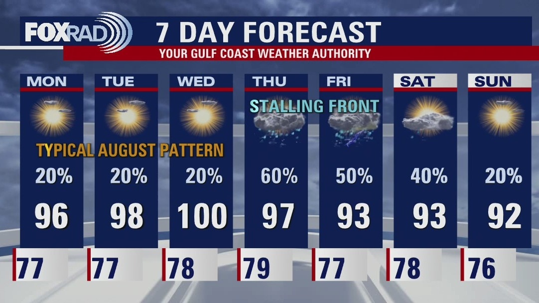
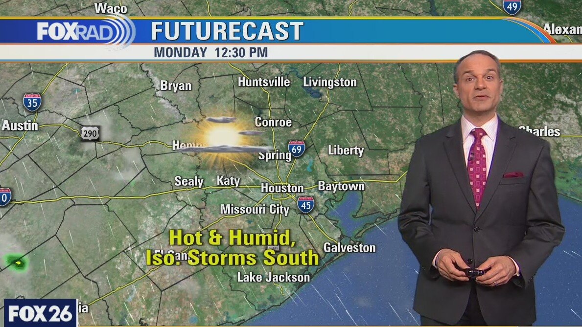
Sunday evening/Monday morning weather forecast
It's back to normal in August for Houston as rain chances will drop down to around 20% for the next several days. Temperatures will also return to the mid to upper 90s for the first half of the week. At the end of the week a front stalls just north of Southeast Texas bringing more clouds and increased chances for rain.
It's back to normal in August for Houston as rain chances will drop down to around 20% for the next several days. Temperatures will also return to the mid to upper 90s for the first half of the week. At the end of the week a front stalls just north of Southeast Texas bringing more clouds and increased chances for rain.