


Friday morning weather with Chief Meteorologist Mike Iscovitz
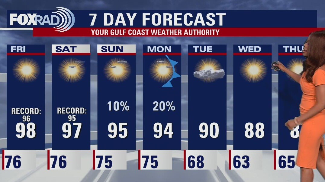
A tropical system will gain strength in the Caribbean this weekend, but a cold front moving toward Texas will most likely steer that potential hurricane away from Houston. In the meantime, expect hot sunshine and record highs today and tomorrow with mid 90s staying with us until Monday. Early next week, a front will bring us much drier air as Florida will be drenched with heavy rain and potentially high winds.
A tropical system will gain strength in the Caribbean this weekend, but a cold front moving toward Texas will most likely steer that potential hurricane away from Houston. In the meantime, expect hot sunshine and record highs today and tomorrow with mid 90s staying with us until Monday. Early next week, a front will bring us much drier air as Florida will be drenched with heavy rain and potentially high winds.
Friday morning weather forecast
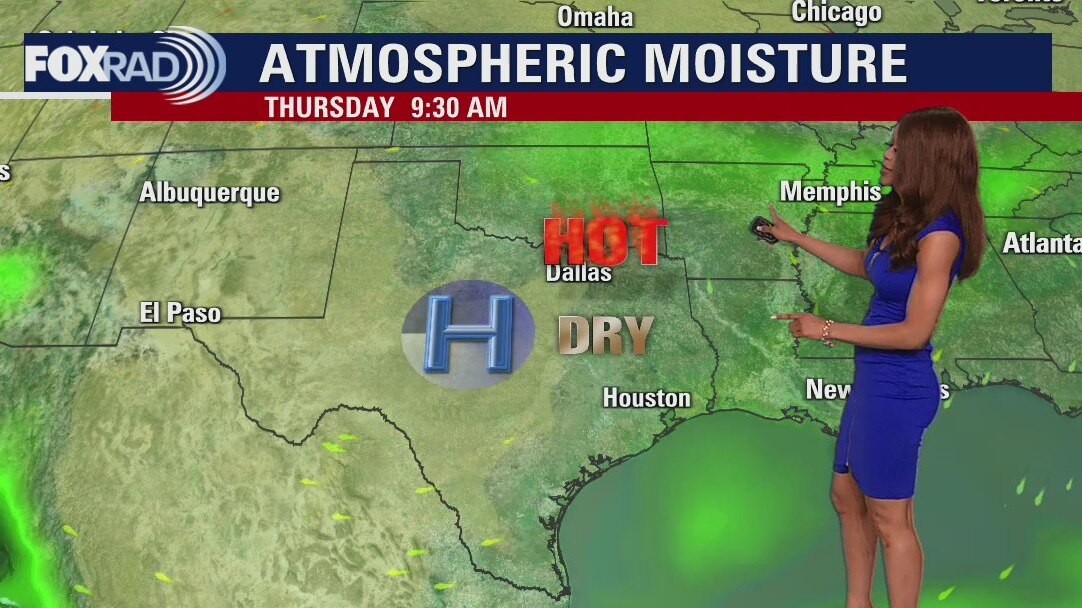
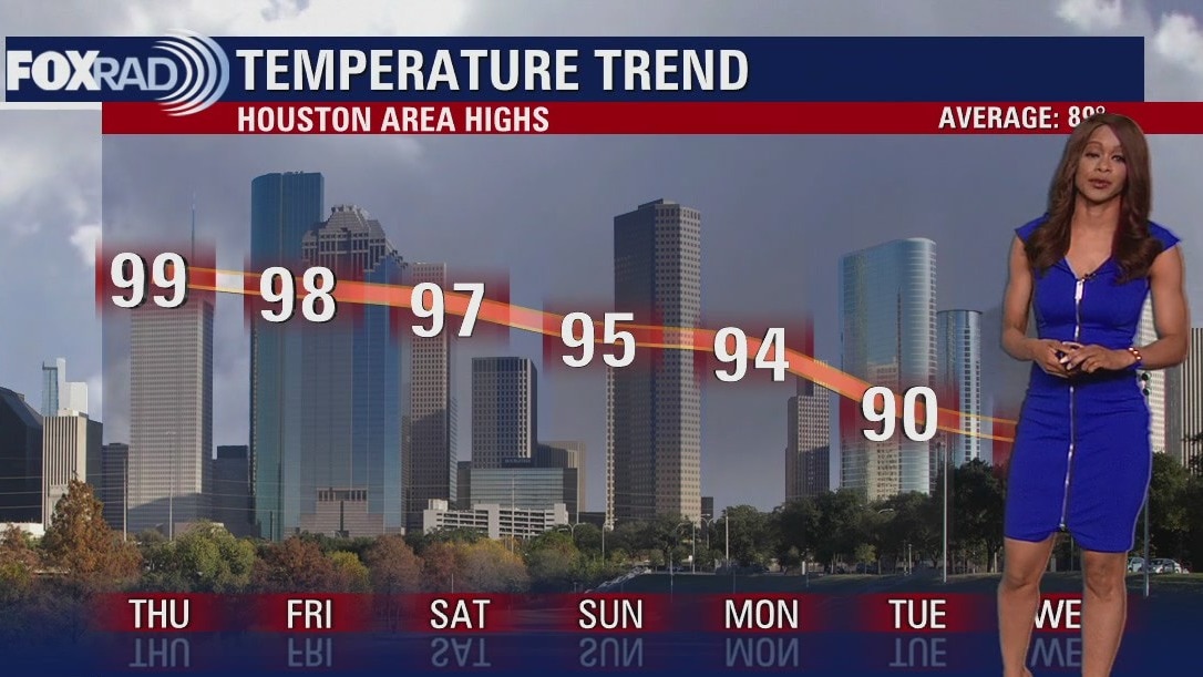
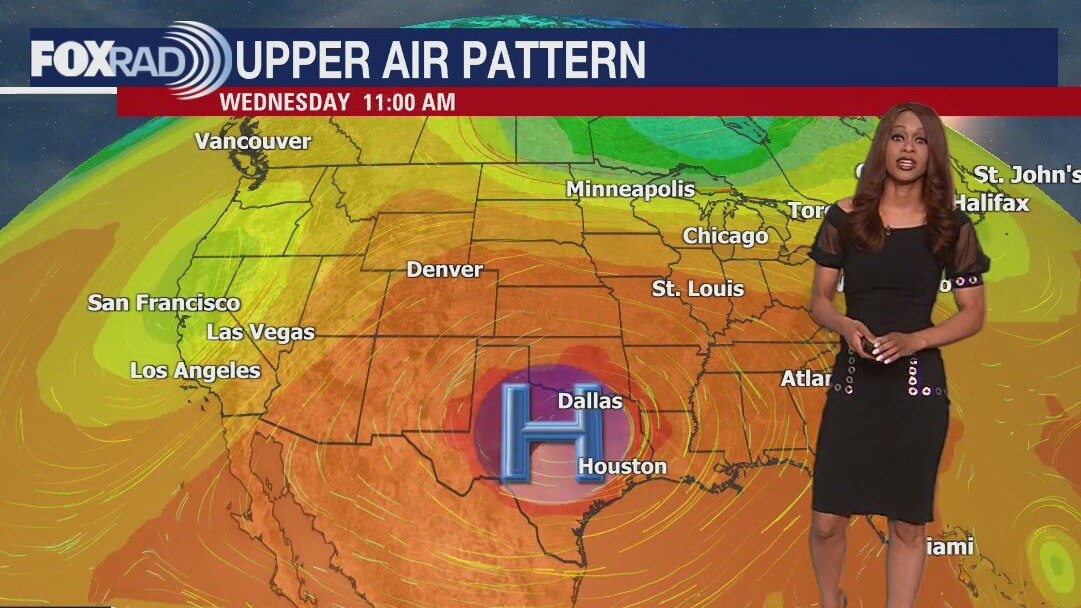
Record heat is expected across Houston over the next few days as a strong ridge of high pressure continues to dominate our area. We will be near triple digits through Saturday with mainly dry weather. Weak cold front is expected to bring some relief next week on Monday and possibly help to steer a tropical system away from SE TX. Tropical wave in the SE Caribbean is expected to move west and has a 80-90% chance for development over the next 2-5 days. Models are projecting this will move W then NW through the Caribbean then turn north into the Gulf of Mexico next week. Models are disagreeing with where it will head once it reaches the Gulf so it is something we are monitoring closely.
Record heat is expected across Houston over the next few days as a strong ridge of high pressure continues to dominate our area. We will be near triple digits through Saturday with mainly dry weather. Weak cold front is expected to bring some relief next week on Monday and possibly help to steer a tropical system away from SE TX. Tropical wave in the SE Caribbean is expected to move west and has a 80-90% chance for development over the next 2-5 days. Models are projecting this will move W then NW through the Caribbean then turn north into the Gulf of Mexico next week. Models are disagreeing with where it will head once it reaches the Gulf so it is something we are monitoring closely.
Thursday afternoon weather forecast with Meteorologist Lena Maria
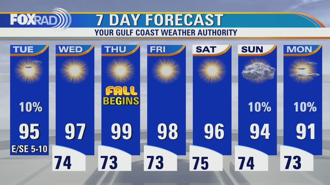
"Fall" begins on a toasty note, with potentially record-breaking heat lingering into the weekend. A cool front will pull in more seasonable, refreshing temperatures and drier air for next week. It also may help act as a boundary, to steer away a developing tropical system. For the latest on that, and all other happenings in the Atlantic visit the tropics tab on our website and our in-depth discussions on YouTube.
"Fall" begins on a toasty note, with potentially record-breaking heat lingering into the weekend. A cool front will pull in more seasonable, refreshing temperatures and drier air for next week. It also may help act as a boundary, to steer away a developing tropical system. For the latest on that, and all other happenings in the Atlantic visit the tropics tab on our website and our in-depth discussions on YouTube.
Sunny and hot with afternoon temperatures in the upper 90s
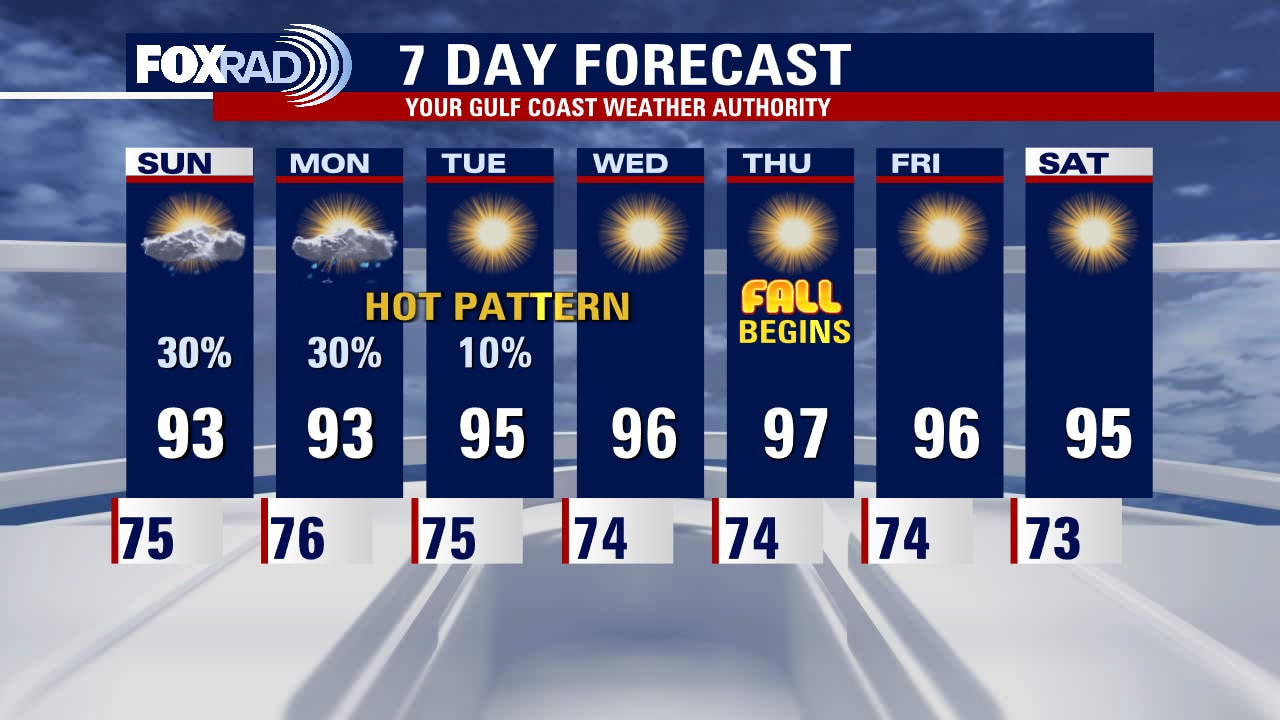
There are three headlines in our forecast over the next 7 days: 1st, record hot temperatures for the start of the fall season. 2nd, a likely tropical storm or hurricane in the Caribbean this weekend. 3rd, a cold front early next week that will bring a nice cooldown for us and could also deflect the aforementioned tropical system. We'll keep you updated on the progress of the low in the Caribbean.
There are three headlines in our forecast over the next 7 days: 1st, record hot temperatures for the start of the fall season. 2nd, a likely tropical storm or hurricane in the Caribbean this weekend. 3rd, a cold front early next week that will bring a nice cooldown for us and could also deflect the aforementioned tropical system. We'll keep you updated on the progress of the low in the Caribbean.
Thursday morning weather forecast
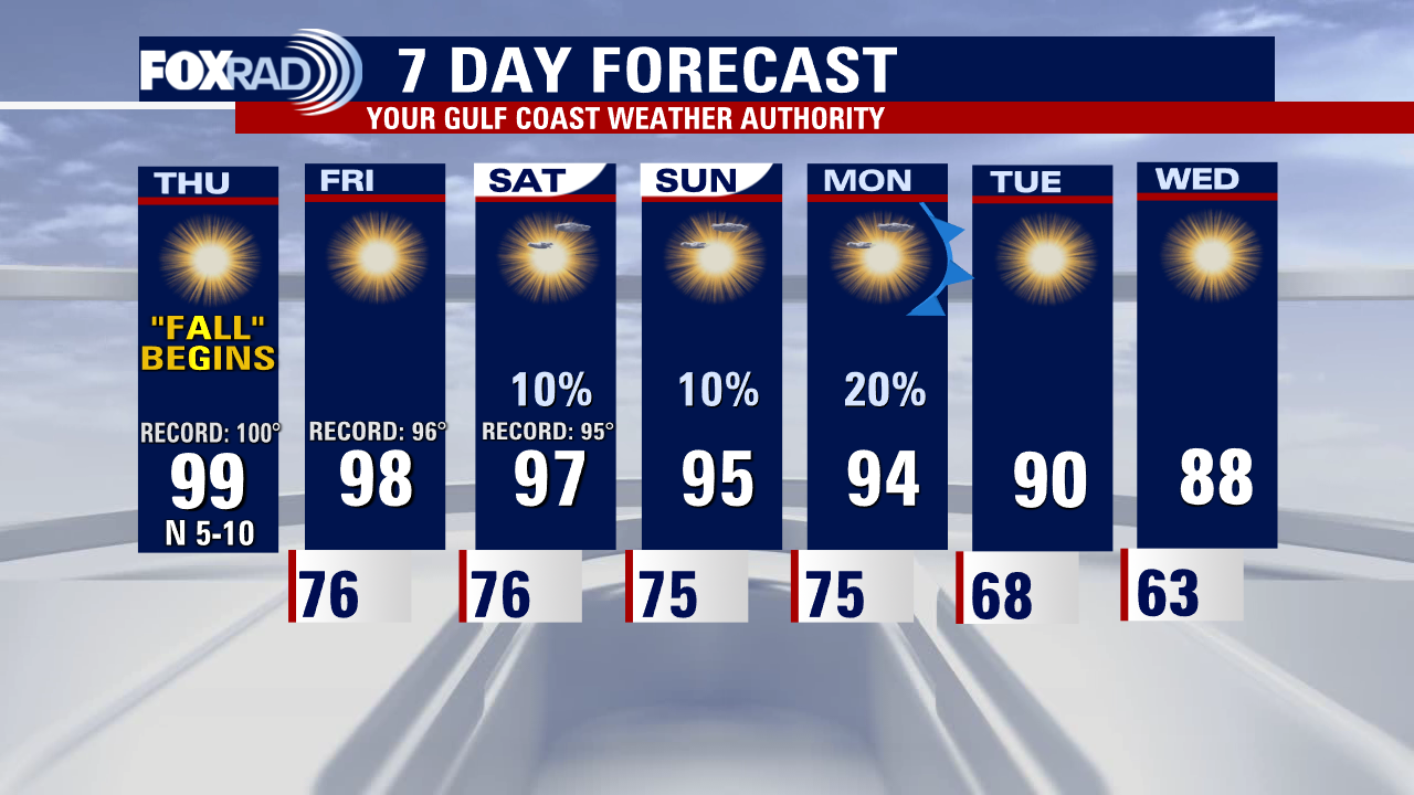
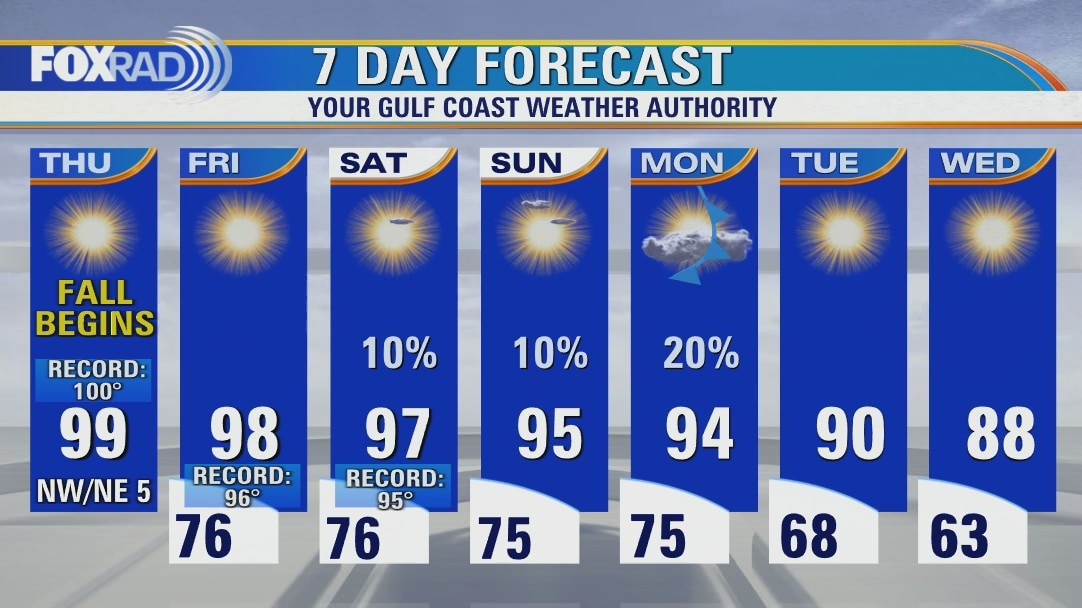
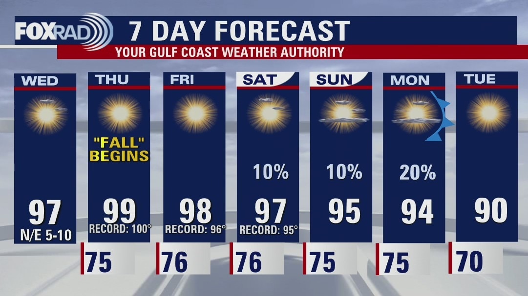
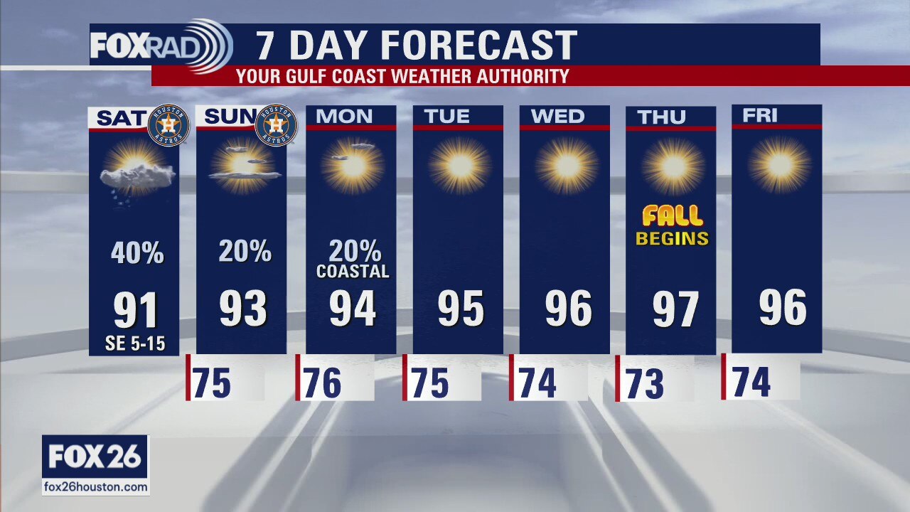
The heat will be the big story through the end of the work week as a strong ridge of high pressure dominates SE Texas. Temperatures soar to near 100 Thursday with record setting upper 90s likely Friday & Saturday. Ridge will gradually break down early next week allowing a weak cold front to slide in bringing slight heat relief next week and a little rain. Highs in the 80s could return by the middle of next week! In the tropics, Fiona will head close to Bermuda as a major hurricane over the next few days with tropical storm Gaston not expected to be a threat. A tropical wave in the southern Atlantic will have a chance to develop and move into the Caribbean and Gulf of Mexico over the next several days. This is the system we are closely monitoring for any possible impact to our area.
The heat will be the big story through the end of the work week as a strong ridge of high pressure dominates SE Texas. Temperatures soar to near 100 Thursday with record setting upper 90s likely Friday & Saturday. Ridge will gradually break down early next week allowing a weak cold front to slide in bringing slight heat relief next week and a little rain. Highs in the 80s could return by the middle of next week! In the tropics, Fiona will head close to Bermuda as a major hurricane over the next few days with tropical storm Gaston not expected to be a threat. A tropical wave in the southern Atlantic will have a chance to develop and move into the Caribbean and Gulf of Mexico over the next several days. This is the system we are closely monitoring for any possible impact to our area.
Wednesday evening weather forecast
The heat will be the big story through the end of the work week as a strong ridge of high pressure dominates SE Texas. Temperatures soar to near 100 Thursday with record setting upper 90s likely Friday & Saturday. Ridge will gradually break down early next week allowing a weak cold front to slide in bringing slight heat relief next week and a little rain. Highs in the 80s could return by the middle of next week! In the tropics, Fiona will head close to Bermuda as a major hurricane over the next few days with tropical storm Gaston not expected to be a threat. A tropical wave in the southern Atlantic will have a chance to develop and move into the Caribbean and Gulf of Mexico over the next several days. This is the system we are closely monitoring for any possible impact to our area.
The heat will be the big story through the end of the work week as a strong ridge of high pressure dominates SE Texas. Temperatures soar to near 100 Thursday with record setting upper 90s likely Friday & Saturday. Ridge will gradually break down early next week allowing a weak cold front to slide in bringing slight heat relief next week and a little rain. Highs in the 80s could return by the middle of next week! In the tropics, Fiona will head close to Bermuda as a major hurricane over the next few days with tropical storm Gaston not expected to be a threat. A tropical wave in the southern Atlantic will have a chance to develop and move into the Caribbean and Gulf of Mexico over the next several days. This is the system we are closely monitoring for any possible impact to our area.
Wednesday weather forecast
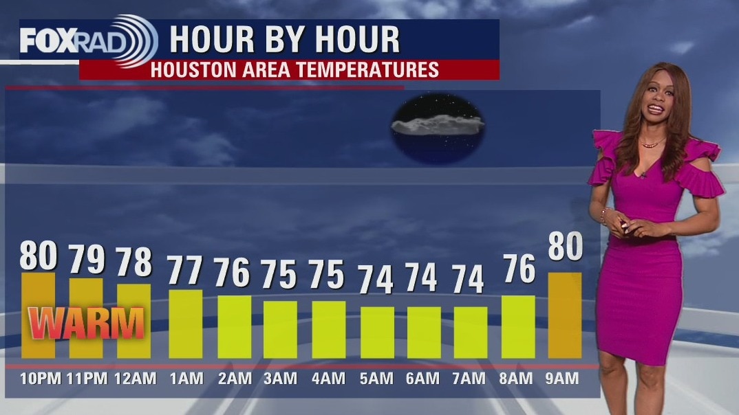
Next few days, it's all about the heat locally. In fact, the first day of "all" will likely be the hottest day of the week! The heat dome will begin to break apart some and shift west over the weekend, allowing for a weak cool front to approach on Monday. We may squeeze out a few showers as the pattern shifts, and can look forward to some cooler less humid air by middle of next week. In the Tropics, Invest 98-L bears watching and could soon become "Hermine" as it treks through the Caribbean, but is a long ways away from being a concern for anyone at this time.
Next few days, it's all about the heat locally. In fact, the first day of "all" will likely be the hottest day of the week! The heat dome will begin to break apart some and shift west over the weekend, allowing for a weak cool front to approach on Monday. We may squeeze out a few showers as the pattern shifts, and can look forward to some cooler less humid air by middle of next week. In the Tropics, Invest 98-L bears watching and could soon become "Hermine" as it treks through the Caribbean, but is a long ways away from being a concern for anyone at this time.
Warm and humid this morning, then sunny and hot
Today is the last day of summer and it's going to be sunny and hot again, but the first day of fall tomorrow will be even hotter. In fact, record highs are possible on Thursday, Friday and Saturday. A weak cold front is on the way early next week and it may arrive just in time to steer a tropical system away from Texas. At this point, all of our major computer models are showing a hurricane approaching the Yucatan, Cuba and/or Florida next week. So far, Texas looks like a less likely target, but it's something we'll watch closely.
Today is the last day of summer and it's going to be sunny and hot again, but the first day of fall tomorrow will be even hotter. In fact, record highs are possible on Thursday, Friday and Saturday. A weak cold front is on the way early next week and it may arrive just in time to steer a tropical system away from Texas. At this point, all of our major computer models are showing a hurricane approaching the Yucatan, Cuba and/or Florida next week. So far, Texas looks like a less likely target, but it's something we'll watch closely.
Wednesday morning weather forecast
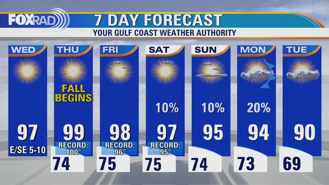
It's all about the heat through the rest of the work week as temperatures soar to near triple digits thanks to a strong ridge of high pressure. This will be near record heat for parts of SE Texas, especially on Thursday and Friday. That means lots of sunshine and mainly dry weather through the weekend. By Monday, a weak cool front will approach bringing a stray shower and some slight heat relief to SE TX. The tropics remain active with Category 3 Hurricane Fiona heading close to Bermuda late Thursday, Tropical Storm Gaston in the central Atlantic and a new tropical wave in the southern Atlantic. This wave is forecast to strengthen and track into the Caribbean and possibly the Gulf of Mexico. It's still several days out, but something we are monitoring closely.
It's all about the heat through the rest of the work week as temperatures soar to near triple digits thanks to a strong ridge of high pressure. This will be near record heat for parts of SE Texas, especially on Thursday and Friday. That means lots of sunshine and mainly dry weather through the weekend. By Monday, a weak cool front will approach bringing a stray shower and some slight heat relief to SE TX. The tropics remain active with Category 3 Hurricane Fiona heading close to Bermuda late Thursday, Tropical Storm Gaston in the central Atlantic and a new tropical wave in the southern Atlantic. This wave is forecast to strengthen and track into the Caribbean and possibly the Gulf of Mexico. It's still several days out, but something we are monitoring closely.
Tuesday evening weather forecast
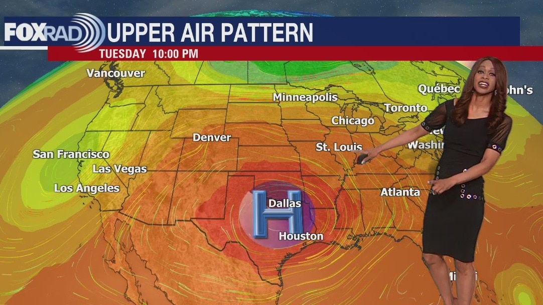
It's all about the heat through the rest of the work week as temperatures soar to near triple digits thanks to a strong ridge of high pressure. This will be near record heat for parts of SE Texas, especially on Thursday and Friday. That means lots of sunshine and mainly dry weather through the weekend. By Monday, a weak cool front will approach bringing a stray shower and some slight heat relief to SE TX. The tropics remain active with Category 3 Hurricane Fiona heading close to Bermuda late Thursday, Tropical Storm Gaston in the central Atlantic and a new tropical wave in the southern Atlantic. This wave is forecast to strengthen and track into the Caribbean and possibly the Gulf of Mexico. It's still several days out, but something we are monitoring closely.
It's all about the heat through the rest of the work week as temperatures soar to near triple digits thanks to a strong ridge of high pressure. This will be near record heat for parts of SE Texas, especially on Thursday and Friday. That means lots of sunshine and mainly dry weather through the weekend. By Monday, a weak cool front will approach bringing a stray shower and some slight heat relief to SE TX. The tropics remain active with Category 3 Hurricane Fiona heading close to Bermuda late Thursday, Tropical Storm Gaston in the central Atlantic and a new tropical wave in the southern Atlantic. This wave is forecast to strengthen and track into the Caribbean and possibly the Gulf of Mexico. It's still several days out, but something we are monitoring closely.
Mostly sunny and hot with highs in the mid 90s
As Hurricane Fiona slams the Turks and Caicos Islands this morning, our weather is looking sunny, hot and mostly rain free. In fact, the first day of fall on Thursday could be the hottest day of the week with highs in the upper 90s. The record high is 100. In the longer term, we'll keep our fingers crossed for a cold front which is possible early next week and a developing tropical disturbance moving into the Caribbean.
As Hurricane Fiona slams the Turks and Caicos Islands this morning, our weather is looking sunny, hot and mostly rain free. In fact, the first day of fall on Thursday could be the hottest day of the week with highs in the upper 90s. The record high is 100. In the longer term, we'll keep our fingers crossed for a cold front which is possible early next week and a developing tropical disturbance moving into the Caribbean.
Tuesday morning weather forecast
The heat will intensify over the next few days. In fact, by the middle of the week, we are likely flirting with triple digits as a big ridge of high pressure gets stronger. This would be near record heat for parts of SE Texas. Hot, humid and mainly dry weather will persist through the weekend with only a very slim shot for rain through early evening and again on Sunday. Tropics remain active with Fiona now an even stronger Category 2 hurricane. It is pulling away from the Dominican Republic and is set to brush by the Turks and Caicos Islands Tuesday where Hurricane Warnings are in place. It is not a threat to Texas or the US east coast but could bring impacts to Bermuda late in the work week.
The heat will intensify over the next few days. In fact, by the middle of the week, we are likely flirting with triple digits as a big ridge of high pressure gets stronger. This would be near record heat for parts of SE Texas. Hot, humid and mainly dry weather will persist through the weekend with only a very slim shot for rain through early evening and again on Sunday. Tropics remain active with Fiona now an even stronger Category 2 hurricane. It is pulling away from the Dominican Republic and is set to brush by the Turks and Caicos Islands Tuesday where Hurricane Warnings are in place. It is not a threat to Texas or the US east coast but could bring impacts to Bermuda late in the work week.

Meet FOX 26 Meteorologist Remeisha Shade; Monday evening weather forecast
The heat will intensify over the next few days. In fact, by the middle of the week, we are likely flirting with triple digits as a big ridge of high pressure gets stronger. This would be near record heat for parts of SE Texas. Hot, humid, and mainly dry weather will persist through the weekend with only a very slim shot for rain through early evening and again on Sunday. Tropics remain active with Fiona now an even stronger Category 2 hurricane. It is pulling away from the Dominican Republic and is set to brush by the Turks and Caicos Islands Tuesday where Hurricane Warnings are in place. It is not a threat to Texas or the US east coast but could bring impacts to Bermuda late in the work week.
The heat will intensify over the next few days. In fact, by the middle of the week, we are likely flirting with triple digits as a big ridge of high pressure gets stronger. This would be near record heat for parts of SE Texas. Hot, humid, and mainly dry weather will persist through the weekend with only a very slim shot for rain through early evening and again on Sunday. Tropics remain active with Fiona now an even stronger Category 2 hurricane. It is pulling away from the Dominican Republic and is set to brush by the Turks and Caicos Islands Tuesday where Hurricane Warnings are in place. It is not a threat to Texas or the US east coast but could bring impacts to Bermuda late in the work week.
Monday afternoon weather forecast with Chief Meteorologist Mike Iscovitz
Fall begins on Thursday, but it won't feel like it right away. We're looking for a hot, humid pattern all week long and into the weekend. A cold front could move in by early next week, so we'll look forward to that, but in the meantime expect highs in the mid to upper 90s. A few storms are possible this afternoon, but they should be brief. In the tropics, Fiona slammed both Puerto Rico and the Dominican Republic and will move toward the Turks and Caicos Islands and possibly Bermuda later this week. It is not a threat to Texas.
Fall begins on Thursday, but it won't feel like it right away. We're looking for a hot, humid pattern all week long and into the weekend. A cold front could move in by early next week, so we'll look forward to that, but in the meantime expect highs in the mid to upper 90s. A few storms are possible this afternoon, but they should be brief. In the tropics, Fiona slammed both Puerto Rico and the Dominican Republic and will move toward the Turks and Caicos Islands and possibly Bermuda later this week. It is not a threat to Texas.

Mostly sunny and hot Monday with a few showers possible
Isolated showers around Southeast Texas on Monday. Houston will then enter a warm and humid pattern with afternoon temperatures closer to record highs than seasonal averages.
Isolated showers around Southeast Texas on Monday. Houston will then enter a warm and humid pattern with afternoon temperatures closer to record highs than seasonal averages.

Sunday night leading into Monday morning weather forecast
Isolated showers around Southeast Texas on Monday. Houston will then enter a warm and humid pattern with afternoon temperatures closer to record highs than seasonal averages.
Isolated showers around Southeast Texas on Monday. Houston will then enter a warm and humid pattern with afternoon temperatures closer to record highs than seasonal averages.
Saturday night leading into Sunday morning weather forecast
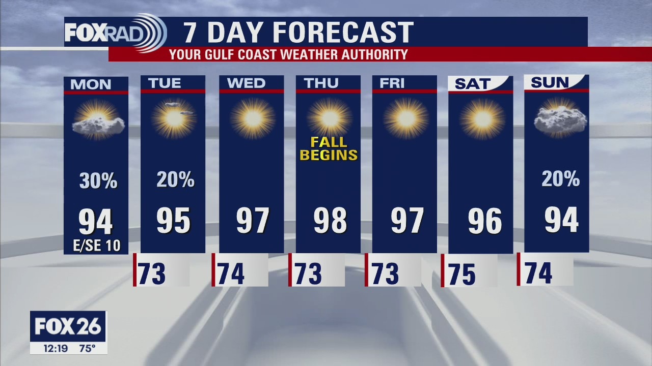
After a steamy Saturday, even more hot and humid weather is on the way for this week. Other than a few pop-up storms on Sunday and Monday, the pattern will be dominated by sunshine and muggy air. Look for highs in the mid to upper 90s with lows in the mid-70s. Fall begins on Thursday and we could see some upper 90s that afternoon.
After a steamy Saturday, even more hot and humid weather is on the way for this week. Other than a few pop-up storms on Sunday and Monday, the pattern will be dominated by sunshine and muggy air. Look for highs in the mid to upper 90s with lows in the mid-70s. Fall begins on Thursday and we could see some upper 90s that afternoon.
Saturday Morning Forecast with Meteorologist Lena Maria Arango
Rain chances decline as we head through the weekend but temperatures will be on the rise well into next week. Humidity, thankfully will peak today and then gradually drop as drier air works in along a building ridge of high pressure. No storms on our horizon, but there are several churning elsewhere bringing major impacts across the globe.
Rain chances decline as we head through the weekend but temperatures will be on the rise well into next week. Humidity, thankfully will peak today and then gradually drop as drier air works in along a building ridge of high pressure. No storms on our horizon, but there are several churning elsewhere bringing major impacts across the globe.

Saturday morning weather forecast
Fall begins on Thursday, but it won't feel like it - we're going to enter the autumn season with hot sunshine. In the meantime, this weekend?s weather will include warm, humid air with hit and miss showers each day. High pressure builds in for most of next week and that means afternoon highs in the mid 90s.
Fall begins on Thursday, but it won't feel like it - we're going to enter the autumn season with hot sunshine. In the meantime, this weekend?s weather will include warm, humid air with hit and miss showers each day. High pressure builds in for most of next week and that means afternoon highs in the mid 90s.

Friday evening weather with Chief Meteorologist Mike Iscovitz
Fall begins on Thursday, but it won't feel like it - we're going to enter the autumn season with hot sunshine. In the meantime, this weekend?s weather will include warm, humid air with hit-and-miss showers each day. High pressure builds in for most of next week and that means afternoon highs in the mid-90s.
Fall begins on Thursday, but it won't feel like it - we're going to enter the autumn season with hot sunshine. In the meantime, this weekend?s weather will include warm, humid air with hit-and-miss showers each day. High pressure builds in for most of next week and that means afternoon highs in the mid-90s.