

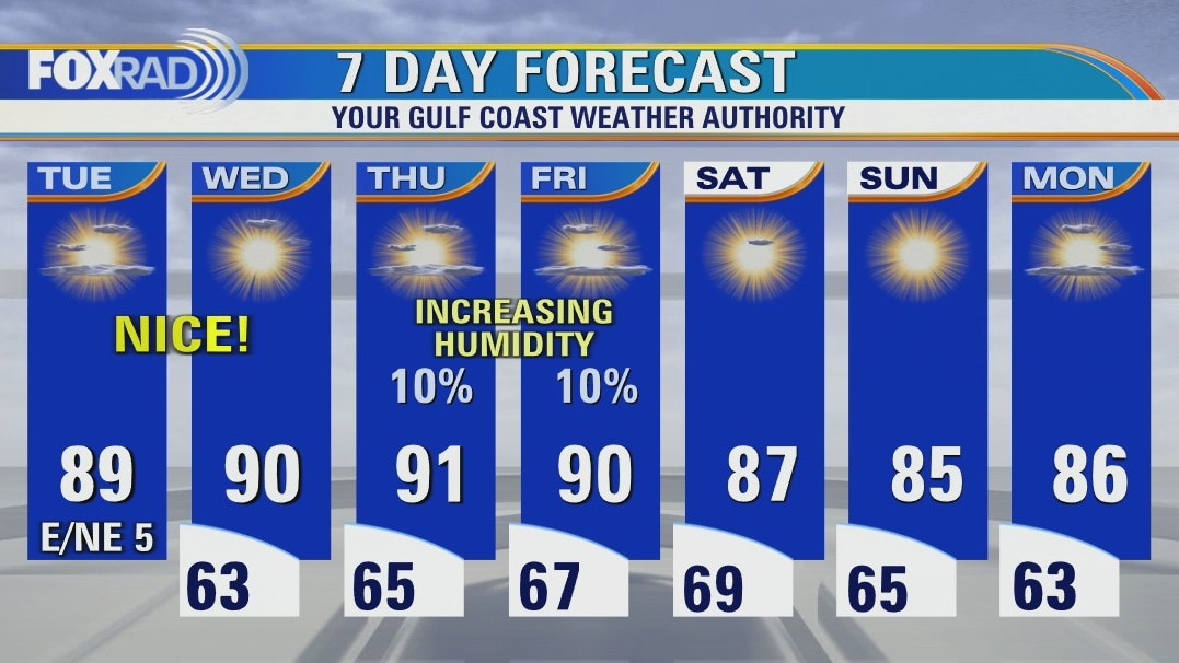
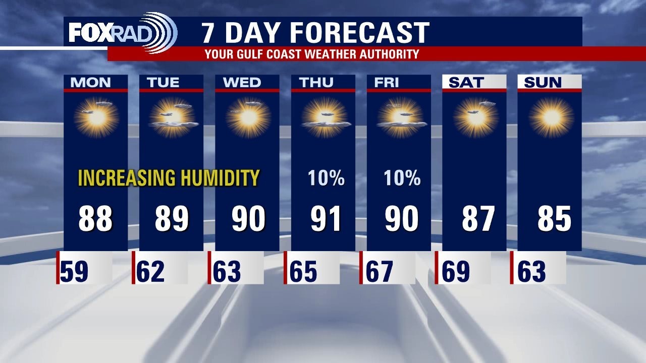
Humidity increases going into Tuesday evening, cold front ushering in
Weather locally still looks awesome with warm afternoons and pleasant mornings. Humidity will be increasing the next few days. Weak cold front drops down late Friday ushering in some drier and slightly cooler air for the weekend. Tropical Depression 12 formed in the far east Caribbean this afternoon but is not expected to be a threat to anyone. Another tropical wave close to the eastern Caribbean may also become a tropical cyclone as it enters the Caribbean over the next few days
Weather locally still looks awesome with warm afternoons and pleasant mornings. Humidity will be increasing the next few days. Weak cold front drops down late Friday ushering in some drier and slightly cooler air for the weekend. Tropical Depression 12 formed in the far east Caribbean this afternoon but is not expected to be a threat to anyone. Another tropical wave close to the eastern Caribbean may also become a tropical cyclone as it enters the Caribbean over the next few days
Warm, dry conditions Tuesday afternoon in the low 80s
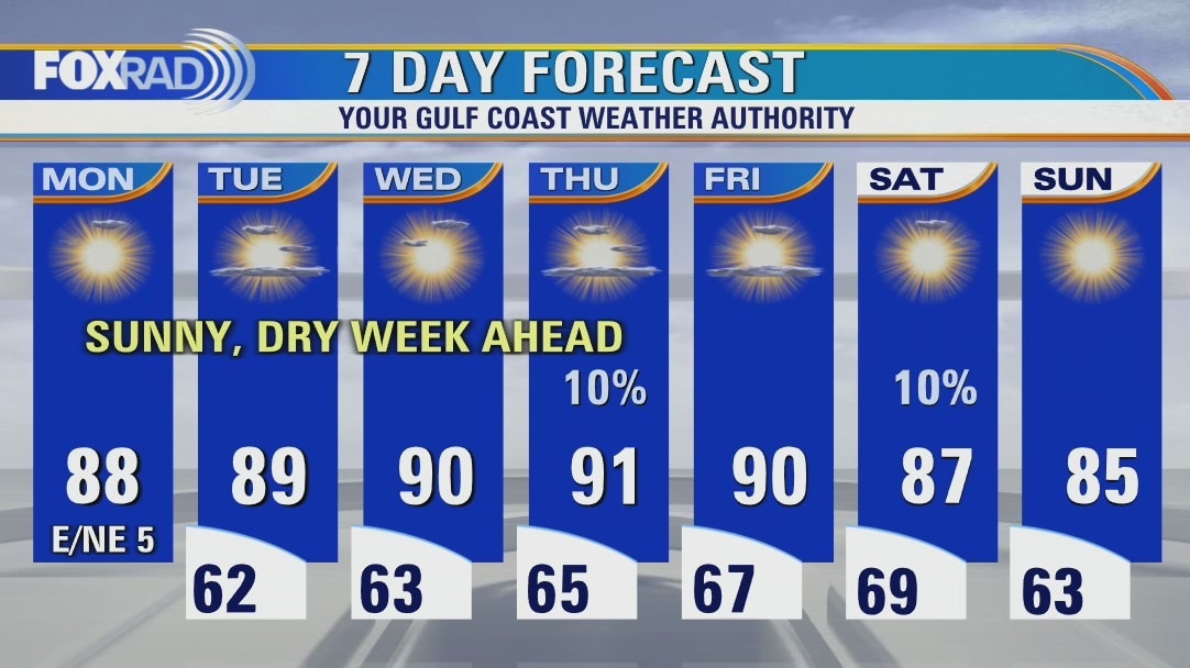
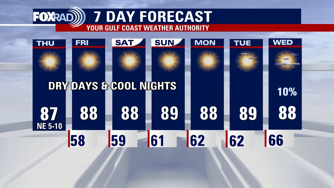
Not too many changes to our beautiful, dry weather pattern. Look for another warm day today with wispy cirrus overhead and highs in the upper 80s. Humidity will increase slowly over the next few days, but overall it will remain dry with a very slight chance for a sprinkle on Thursday and Friday. Elsewhere, there are two disturbances in the Atlantic. One that is very far away in the eastern Atlantic could become a tropical storm this week and a smaller one will enter the Caribbean this week and could slowly strengthen but is unlikely to affect Texas.
Not too many changes to our beautiful, dry weather pattern. Look for another warm day today with wispy cirrus overhead and highs in the upper 80s. Humidity will increase slowly over the next few days, but overall it will remain dry with a very slight chance for a sprinkle on Thursday and Friday. Elsewhere, there are two disturbances in the Atlantic. One that is very far away in the eastern Atlantic could become a tropical storm this week and a smaller one will enter the Caribbean this week and could slowly strengthen but is unlikely to affect Texas.
Clear and pleasant Tuesday morning, then mostly sunny and warm
Not too many changes to our beautiful, dry weather pattern. Look for another warm day today with wispy cirrus overhead and highs in the upper 80s. Humidity will increase slowly over the next few days, but overall it will remain dry with a very slight chance for a sprinkle on Thursday and Friday. Elsewhere, there are two disturbances in the Atlantic. One that is very far away in the eastern Atlantic could become a tropical storm this week and a smaller one will enter the Caribbean this week and could slowly strengthen, but is unlikely to affect Texas.
Not too many changes to our beautiful, dry weather pattern. Look for another warm day today with wispy cirrus overhead and highs in the upper 80s. Humidity will increase slowly over the next few days, but overall it will remain dry with a very slight chance for a sprinkle on Thursday and Friday. Elsewhere, there are two disturbances in the Atlantic. One that is very far away in the eastern Atlantic could become a tropical storm this week and a smaller one will enter the Caribbean this week and could slowly strengthen, but is unlikely to affect Texas.

Monday night leading into Tuesday morning weather forecast with Meteorologist Remeisha Shade
Two tropical waves are being monitored in the Atlantic for development but at this point, there are no named systems in the Atlantic. Local weather remains quiet with just some high clouds from Tropical Depression Orlene reaching us. Look for humidity to slowly increase this week and temperatures to get a bit hotter. The cold front may reach us later in the week but won't bring much rain.
Two tropical waves are being monitored in the Atlantic for development but at this point, there are no named systems in the Atlantic. Local weather remains quiet with just some high clouds from Tropical Depression Orlene reaching us. Look for humidity to slowly increase this week and temperatures to get a bit hotter. The cold front may reach us later in the week but won't bring much rain.

Monday evening weather forecast with Meteorologist Remeisha Shade
Two tropical waves are being monitored in the Atlantic for development but at this point, there are no named systems in the Atlantic. Local weather remains quiet with just some high clouds from Tropical Depression Orlene reaching us. Look for humidity to slowly increase this week and temperatures get a bit hotter. Cold front may reach us late week but won't bring much rain.
Two tropical waves are being monitored in the Atlantic for development but at this point, there are no named systems in the Atlantic. Local weather remains quiet with just some high clouds from Tropical Depression Orlene reaching us. Look for humidity to slowly increase this week and temperatures get a bit hotter. Cold front may reach us late week but won't bring much rain.
Partly cloudy and pleasant Monday afternoon in the 80s
Our pattern of dry, pleasant days will continue this week with morning lows in the 60s and highs in the upper 80s and some low 90s. You may notice some high cirrus clouds in the sky today and tomorrow - those are blowing off of Hurricane Orlene which is hitting the Pacific coast of Mexico and will have no other effects on our area. Otherwise, we'll monitor a tropical disturbance in the Atlantic that could get a bit strong as it heads toward the Caribbean this week, but is unlikely to affect Texas.
Our pattern of dry, pleasant days will continue this week with morning lows in the 60s and highs in the upper 80s and some low 90s. You may notice some high cirrus clouds in the sky today and tomorrow - those are blowing off of Hurricane Orlene which is hitting the Pacific coast of Mexico and will have no other effects on our area. Otherwise, we'll monitor a tropical disturbance in the Atlantic that could get a bit strong as it heads toward the Caribbean this week, but is unlikely to affect Texas.
Cool Monday morning, then sunny and warm
Our pattern of dry, pleasant days will continue this week with morning lows in the 60s and highs in the upper 80s and some low 90s. You may notice some high cirrus clouds in the sky today and tomorrow - those are blowing off of Hurricane Orlene which is hitting the Pacific coast of Mexico and will have no other effects on our area. Otherwise, we'll monitor a tropical disturbance in the Atlantic that could get a bit strong as it heads toward the Caribbean this week, but is unlikely to affect Texas.
Our pattern of dry, pleasant days will continue this week with morning lows in the 60s and highs in the upper 80s and some low 90s. You may notice some high cirrus clouds in the sky today and tomorrow - those are blowing off of Hurricane Orlene which is hitting the Pacific coast of Mexico and will have no other effects on our area. Otherwise, we'll monitor a tropical disturbance in the Atlantic that could get a bit strong as it heads toward the Caribbean this week, but is unlikely to affect Texas.
Sunday night leading into Monday morning weather forecast
Lots of sunshine and ragweed to talk about in the forecast for Houston. Look for a slight and gradual warming trend to take place as our pattern shifts a bit, higher humidity will lead to an increase in cloud cover but rain chances remain very low. A front will approach Southeast Texas next weekend but at this point, it is not clear if it will make it all the way to the Gulf Coast.
Lots of sunshine and ragweed to talk about in the forecast for Houston. Look for a slight and gradual warming trend to take place as our pattern shifts a bit, higher humidity will lead to an increase in cloud cover but rain chances remain very low. A front will approach Southeast Texas next weekend but at this point, it is not clear if it will make it all the way to the Gulf Coast.

Sunday Morning Forecast with Meteorologist Lena Maria Arango
Blissful tailgate weather for the Texans game at NRG, and a pleasant evening if you're catching the Rockets first pre-season home game! Abundant sunshine continues to produce high levels of ozone, which may be bothersome. Ragweed pollen is also very high. A slight and gradual warming trend will take place as our pattern shifts a bit, higher humidity will lead to an increase in cloud cover but rain chances remain slim. There are a couple of disturbances lurking way out in the Atlantic, just something to monitor for now.
Blissful tailgate weather for the Texans game at NRG, and a pleasant evening if you're catching the Rockets first pre-season home game! Abundant sunshine continues to produce high levels of ozone, which may be bothersome. Ragweed pollen is also very high. A slight and gradual warming trend will take place as our pattern shifts a bit, higher humidity will lead to an increase in cloud cover but rain chances remain slim. There are a couple of disturbances lurking way out in the Atlantic, just something to monitor for now.
Sunday morning weather forecast
Cooler temps stick around for the weekend.
Cooler temps stick around for the weekend.


Sunday morning weather forecast
The Fall-like weather continues for Southeast Texas. Look for mostly sunny and warm days with pleasant nights. Humidity will start to slowly increase a bit but very few chances for rain most of the week. There is an Ozone Action Day for Houston on Sunday.
The Fall-like weather continues for Southeast Texas. Look for mostly sunny and warm days with pleasant nights. Humidity will start to slowly increase a bit but very few chances for rain most of the week. There is an Ozone Action Day for Houston on Sunday.
Sunday morning weather forecast
The Fall-like weather continues for Southeast Texas. Look for mostly sunny and warm days with pleasant nights. Humidity will start to slowly increase a bit but very little chances for rain most of the week. There is an Ozone Action Day for Houston on Sunday.
The Fall-like weather continues for Southeast Texas. Look for mostly sunny and warm days with pleasant nights. Humidity will start to slowly increase a bit but very little chances for rain most of the week. There is an Ozone Action Day for Houston on Sunday.

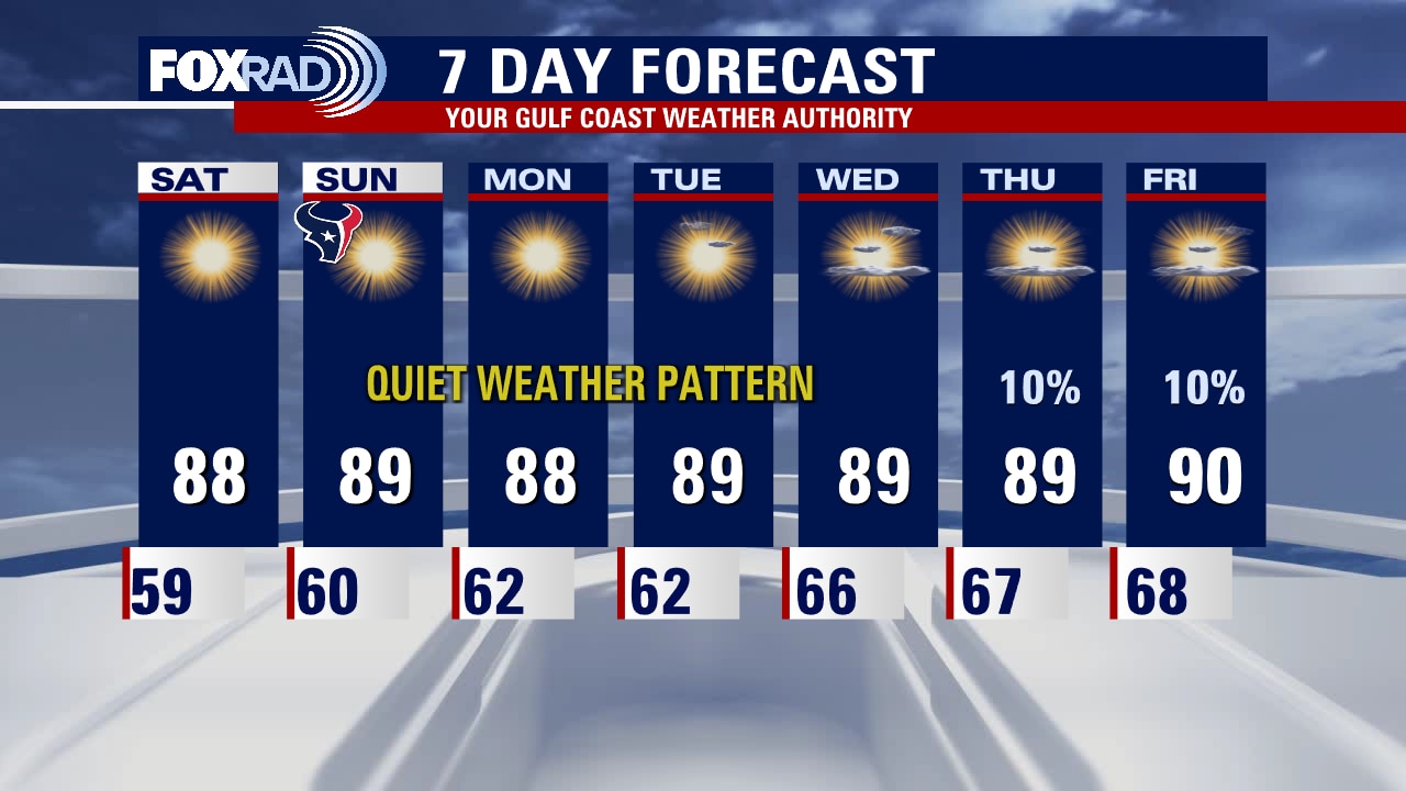
Saturday morning weather forecast
Very dry air will remain in place over the weekend and early next week. By mid-late next week, moisture will start to increase a bit and that will mean more humidity but still only a slim chance for rain. Look for mostly sunny and warm days with pleasant nights. IAN is now a Post Tropical with and made landfall early this afternoon over Georgetown, SC. It will track north weakening over the next few days as it still spreads heavy rain, gusty winds and the threat for a few tornadoes across the Carolinas and Mid-Atlantic.
Very dry air will remain in place over the weekend and early next week. By mid-late next week, moisture will start to increase a bit and that will mean more humidity but still only a slim chance for rain. Look for mostly sunny and warm days with pleasant nights. IAN is now a Post Tropical with and made landfall early this afternoon over Georgetown, SC. It will track north weakening over the next few days as it still spreads heavy rain, gusty winds and the threat for a few tornadoes across the Carolinas and Mid-Atlantic.
Friday evening weather forecast with Meteorologist Remeisha Shade
Very dry air will remain in place over the weekend and early next week. By mid-late next week, moisture will start to increase a bit and that will mean more humidity but still only a slim chance for rain. Look for mostly sunny and warm days with pleasant nights. IAN is now a Post Tropical with and made landfall early this afternoon over Georgetown, SC. It will track north weakening over the next few days as it still spreads heavy rain, gusty winds, and the threat of a few tornadoes across the Carolinas and Mid-Atlantic.
Very dry air will remain in place over the weekend and early next week. By mid-late next week, moisture will start to increase a bit and that will mean more humidity but still only a slim chance for rain. Look for mostly sunny and warm days with pleasant nights. IAN is now a Post Tropical with and made landfall early this afternoon over Georgetown, SC. It will track north weakening over the next few days as it still spreads heavy rain, gusty winds, and the threat of a few tornadoes across the Carolinas and Mid-Atlantic.

Tropical Weather Forecast - September 30, 2022
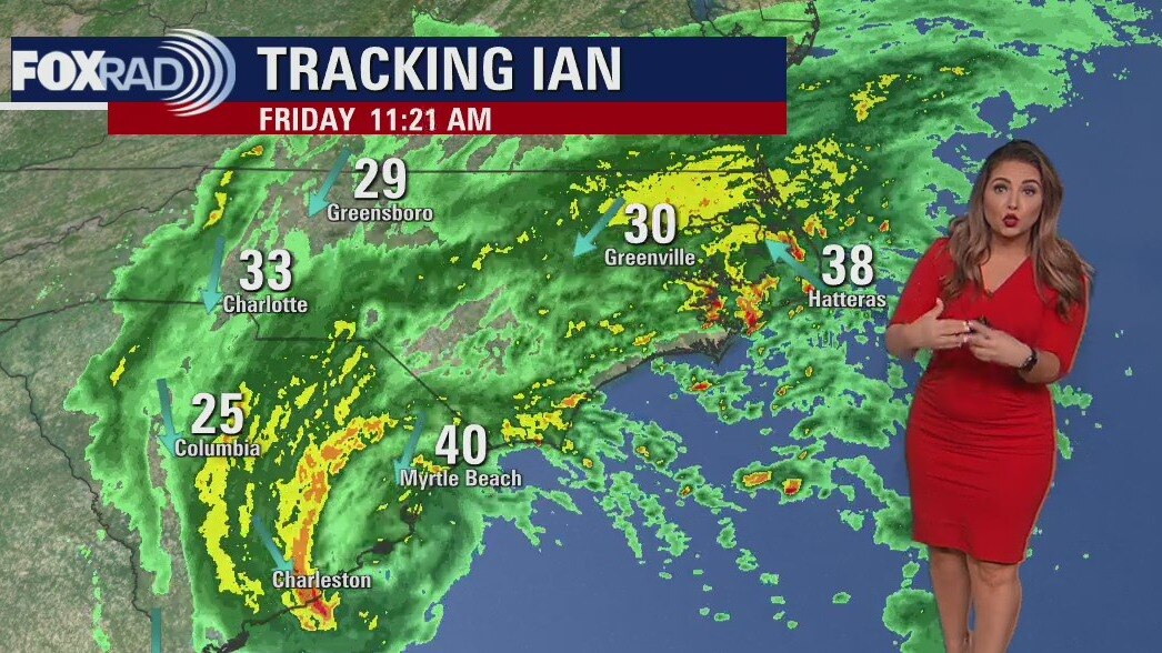
Ian made landfall as a Category 1 hurricane around 1:05 p.m. Friday near Georgetown, SC with 85 mph winds. IAN as of the latest advisory has become Post-Tropical which means it is no longer a tropical cyclone but still poses a heavy rain and wind threat as it weakens and moves north over the Carolinas and West Virginia.
Ian made landfall as a Category 1 hurricane around 1:05 p.m. Friday near Georgetown, SC with 85 mph winds. IAN as of the latest advisory has become Post-Tropical which means it is no longer a tropical cyclone but still poses a heavy rain and wind threat as it weakens and moves north over the Carolinas and West Virginia.
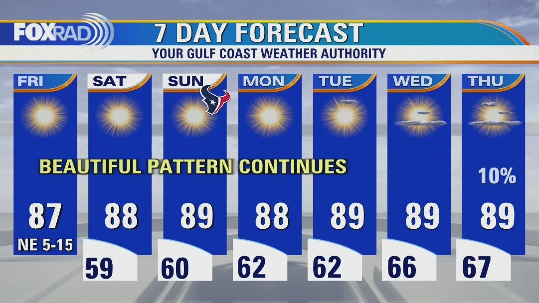
Low humidity and plenty sunshine Friday afternoon, elevated risk of fire
After making landfall one last time along the Carolina coast today, Hurricane Ian is set to rapidly weaken as it pushes inland. Impacts will still be felt as far north as the mid-Atlantic through the weekend due to remnant moisture. Locally, a continuous pleasant stretch continues. Be mindful of an elevated fire risk and high allergens if spending time outside this weekend. Otherwise, enjoy the sunshine and low humidity!
After making landfall one last time along the Carolina coast today, Hurricane Ian is set to rapidly weaken as it pushes inland. Impacts will still be felt as far north as the mid-Atlantic through the weekend due to remnant moisture. Locally, a continuous pleasant stretch continues. Be mindful of an elevated fire risk and high allergens if spending time outside this weekend. Otherwise, enjoy the sunshine and low humidity!
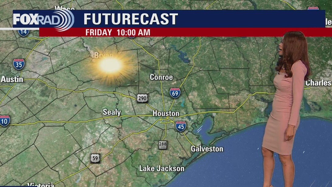
Clear and pleasant Friday morning, then sunny and dry
Hurricane Ian will impact the Carolinas today with gusty winds, storm surge and heavy rain, but our weather couldn't be nicer. One caution is that waves from Hurricane Ian could increase the risk for rip currents at our beaches for today and Saturday. Otherwise, overnight lows will reach the 50s and low 60s (the coolest since April) and afternoons will bring warm sunshine and very low humidity. This pattern will stay in place through at least the middle of next week.
Hurricane Ian will impact the Carolinas today with gusty winds, storm surge and heavy rain, but our weather couldn't be nicer. One caution is that waves from Hurricane Ian could increase the risk for rip currents at our beaches for today and Saturday. Otherwise, overnight lows will reach the 50s and low 60s (the coolest since April) and afternoons will bring warm sunshine and very low humidity. This pattern will stay in place through at least the middle of next week.
Friday morning weather forecast
Stellar weather continues for SE Texas if you like sunshine and low humidity! It will be more of the same through the end of the week with temperatures in the upper 80s during the afternoon and cooler nights in the 50s. Ian is once again a hurricane set to make another landfall along the South Carolina coast early Friday afternoon. The Carolinas will be threatened with major flooding, storm surge, and hurricane-force winds Friday.
Stellar weather continues for SE Texas if you like sunshine and low humidity! It will be more of the same through the end of the week with temperatures in the upper 80s during the afternoon and cooler nights in the 50s. Ian is once again a hurricane set to make another landfall along the South Carolina coast early Friday afternoon. The Carolinas will be threatened with major flooding, storm surge, and hurricane-force winds Friday.

Thursday evening weather with Meteorologist Remeisha Shade
Stellar weather continues for SE Texas if you like sunshine and low humidity! It will be more of the same through the end of the week with temperatures in the upper 80s during the afternoon and cooler nights in the 50s. Ian is once again a hurricane set to make another landfall along the South Carolina coast early Friday afternoon. The Carolinas will be threatened with major flooding, storm surge, and hurricane-force winds Friday.
Stellar weather continues for SE Texas if you like sunshine and low humidity! It will be more of the same through the end of the week with temperatures in the upper 80s during the afternoon and cooler nights in the 50s. Ian is once again a hurricane set to make another landfall along the South Carolina coast early Friday afternoon. The Carolinas will be threatened with major flooding, storm surge, and hurricane-force winds Friday.
Thursday afternoon weather forecast with Meteorologist Lena Maria
Our local weather remains very quiet and pleasant, though you may notice an increase in allergens and the dry conditions have created a bit of an elevated fire risk. Our drought has also slightly worsened, and as you can see - really, no rain in sight. As now TS Ian moves away from the Florida coastline, rescue efforts can begin though the road to recovery will be long. Ian looks to strengthen to a Category 1 Hurricane again, before making a 3rd landfall along the Carolina Coastline where a Hurricane Warning is already in effect.
Our local weather remains very quiet and pleasant, though you may notice an increase in allergens and the dry conditions have created a bit of an elevated fire risk. Our drought has also slightly worsened, and as you can see - really, no rain in sight. As now TS Ian moves away from the Florida coastline, rescue efforts can begin though the road to recovery will be long. Ian looks to strengthen to a Category 1 Hurricane again, before making a 3rd landfall along the Carolina Coastline where a Hurricane Warning is already in effect.