

Saturday night leading into Sunday morning weather forecast
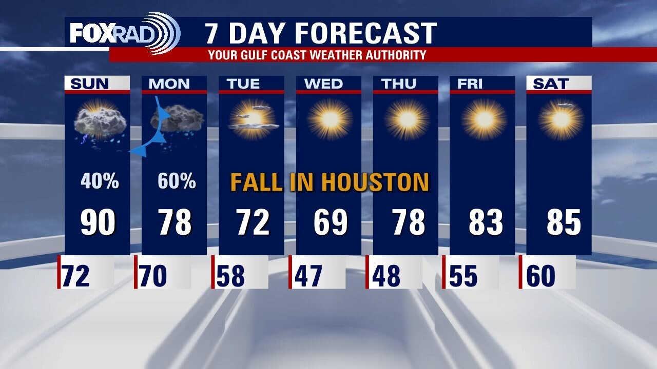
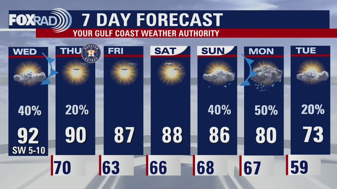
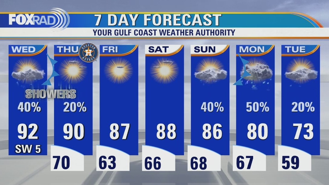
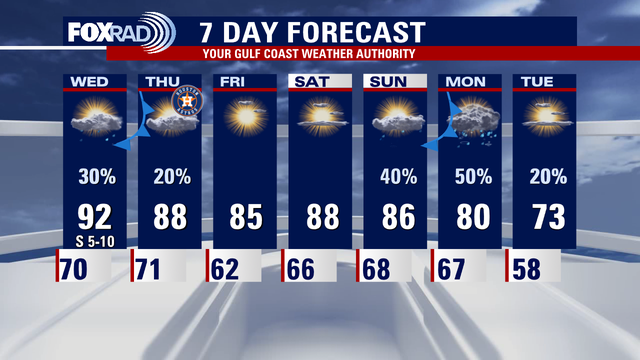
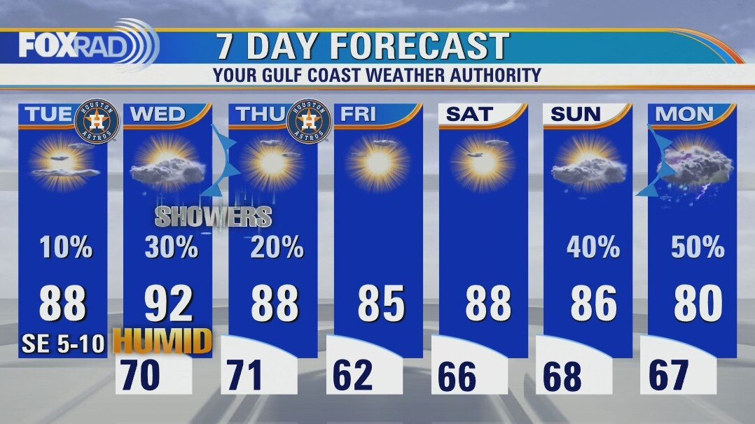
Hang in there Houston. Just one more day of really warm weather before a true taste of Fall starts moving into Southeast Texas. The Monday cold front will bring showers/storms peaking at the morning rush hour. Slowly skies start clearing overnight into Tuesday morning. Find your long sleeves and warmer clothes for the second half of the week.
Hang in there Houston. Just one more day of really warm weather before a true taste of Fall starts moving into Southeast Texas. The Monday cold front will bring showers/storms peaking at the morning rush hour. Slowly skies start clearing overnight into Tuesday morning. Find your long sleeves and warmer clothes for the second half of the week.

Saturday Morning Forecast with Meteorologist Lena Maria Arango
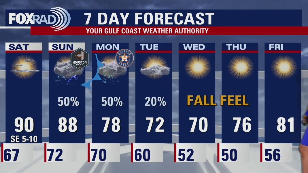
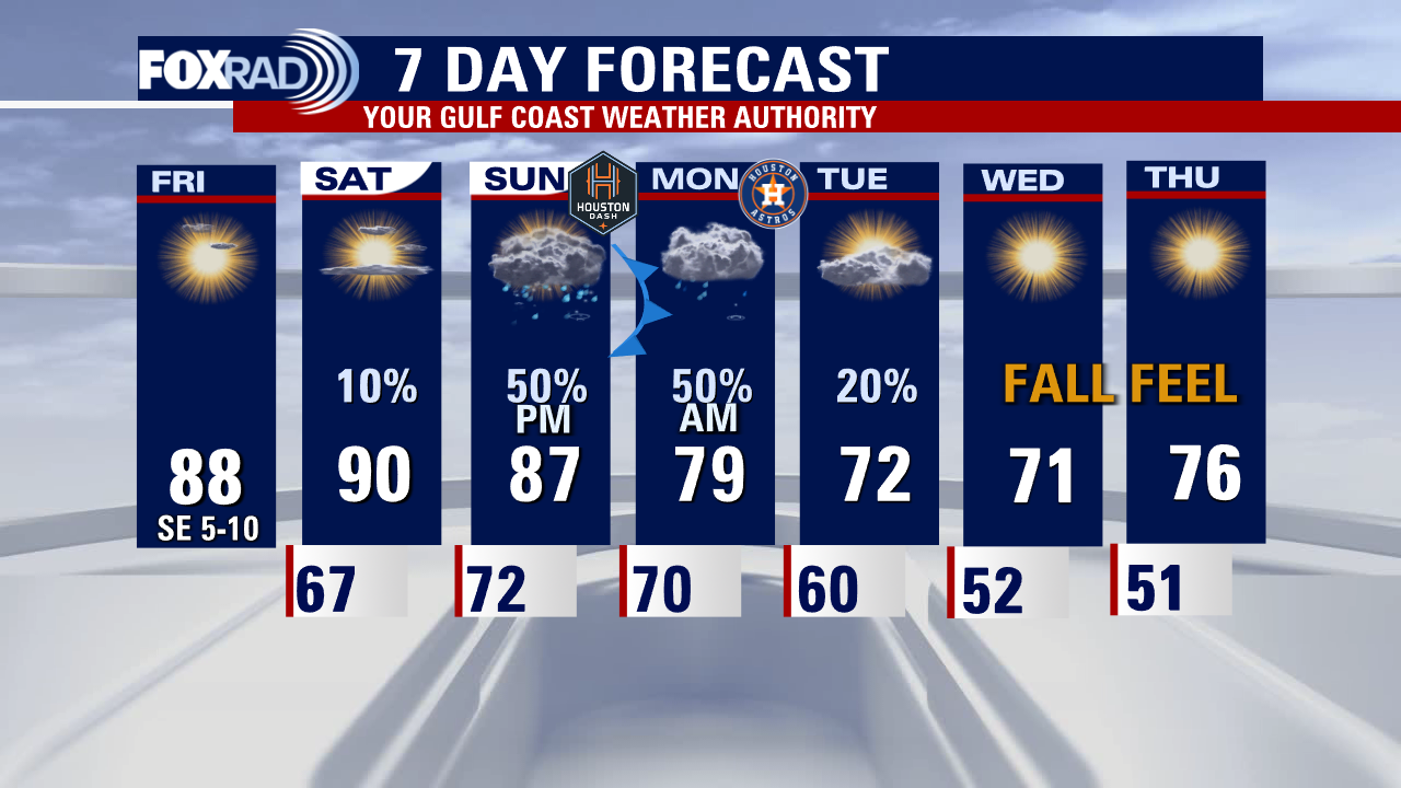
Today is your better bet for outdoor plans this weekend, though it will be warm and humid. Sunday starts dry, but cloudy with rain chances increasing in the afternoon-evening and that could impact the Dash playoff game at PNC. Most of the moisture though looks to arrive early morning hours of Monday, as the front collides with our very humid airmass. This looks to lead to a messy Monday morning commute, in particular for points west. Rain will gradually taper to showers by late Monday/early Tuesday and then it's time to pull out the jackets. After several days of a solid fall feel, we'll gradually warm closer to average as we head into the weekend.
Today is your better bet for outdoor plans this weekend, though it will be warm and humid. Sunday starts dry, but cloudy with rain chances increasing in the afternoon-evening and that could impact the Dash playoff game at PNC. Most of the moisture though looks to arrive early morning hours of Monday, as the front collides with our very humid airmass. This looks to lead to a messy Monday morning commute, in particular for points west. Rain will gradually taper to showers by late Monday/early Tuesday and then it's time to pull out the jackets. After several days of a solid fall feel, we'll gradually warm closer to average as we head into the weekend.
Saturday morning weather forecast
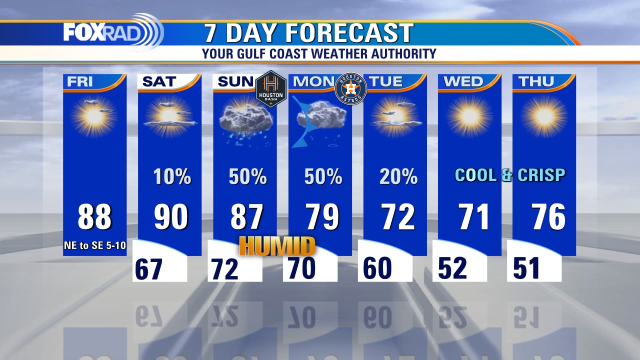
It's been a great Friday with warm but quiet weather and slightly drier air building in. Temps will remain warm heading into the weekend with highs near 90 Saturday and upper 80s Sunday afternoon. Humidity will increase as well. Strong cold front will head our way Sunday PM into Monday bringing scattered showers and storms followed by a big drop in temperatures for much of next week. Enjoy your weekend!
It's been a great Friday with warm but quiet weather and slightly drier air building in. Temps will remain warm heading into the weekend with highs near 90 Saturday and upper 80s Sunday afternoon. Humidity will increase as well. Strong cold front will head our way Sunday PM into Monday bringing scattered showers and storms followed by a big drop in temperatures for much of next week. Enjoy your weekend!
Friday evening weather forecast
It's been a great Friday with warm but quiet weather and slightly drier air building in. Temps will remain warm heading into the weekend with highs near 90 Saturday and upper 80s Sunday afternoon. Humidity will increase as well. Strong cold front will head our way Sunday PM into Monday bringing scattered showers and storms followed by a big drop in temperatures for much of next week. Enjoy your weekend!
It's been a great Friday with warm but quiet weather and slightly drier air building in. Temps will remain warm heading into the weekend with highs near 90 Saturday and upper 80s Sunday afternoon. Humidity will increase as well. Strong cold front will head our way Sunday PM into Monday bringing scattered showers and storms followed by a big drop in temperatures for much of next week. Enjoy your weekend!
Mostly dry, sunny, warm this Friday afternoon
Dry and pleasant today, warm and humid tomorrow, very muggy by Sunday. The latest models bring in our next front overnight Sunday into early Monday, with rain tapering by late afternoon-early evening in the unlikely event that we have to bring things home for a game 4. A few coastal showers may be around early Tuesday as the front continues to work its way off shore. Behind that, a cool, crisp fall-like feel looks to linger for several days.
Dry and pleasant today, warm and humid tomorrow, very muggy by Sunday. The latest models bring in our next front overnight Sunday into early Monday, with rain tapering by late afternoon-early evening in the unlikely event that we have to bring things home for a game 4. A few coastal showers may be around early Tuesday as the front continues to work its way off shore. Behind that, a cool, crisp fall-like feel looks to linger for several days.
Friday morning weather forecast with Meteorologist Lena Maria
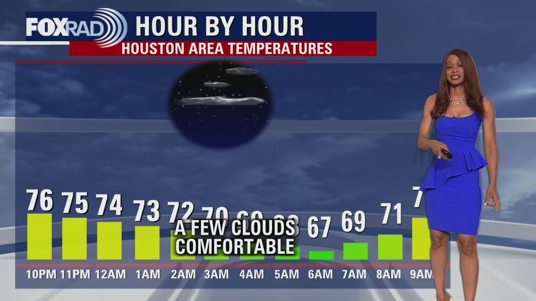
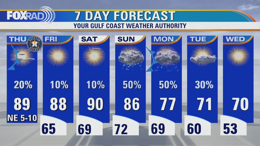
The work week ends on a pleasant note, with humidity building as we head into the weekend. Outdoor plans look great for Friday and Saturday, by Sunday rain chances will increase. Plan for at least scattered light-moderate showers around on Sunday, remaining showery on Monday as the front works through. A few isolated storms imbedded in the mix may boost rain totals for some. The real treat will be the post-front cool down, and all of us will get in on that action. By Wednesday morning, some of us will be waking up in the 40s if not 50s with afternoon highs likely not making it past the 70s for a few days!
The work week ends on a pleasant note, with humidity building as we head into the weekend. Outdoor plans look great for Friday and Saturday, by Sunday rain chances will increase. Plan for at least scattered light-moderate showers around on Sunday, remaining showery on Monday as the front works through. A few isolated storms imbedded in the mix may boost rain totals for some. The real treat will be the post-front cool down, and all of us will get in on that action. By Wednesday morning, some of us will be waking up in the 40s if not 50s with afternoon highs likely not making it past the 70s for a few days!
Friday morning weather forecast
There's a marginal risk for a few strong storms through the evening hours as a weak front lingers near the coast. Main threats with any storms that develop would be heavy downpours, frequent lightning, hail up to quarter size and the threat for strong winds around 50-60 mph. Storm chance is around 20-30% and storms should fade by 10-11 pm. Warm but dry weather is expected Friday & Saturday before a stronger fall cold front brings decent rain chances and cooler air early next week. Tropical Storm Karl is tracking south towards SE Mexico with 45 mph winds and is expected to make landfall as a weak tropical storm in southern Mexico Friday night.
There's a marginal risk for a few strong storms through the evening hours as a weak front lingers near the coast. Main threats with any storms that develop would be heavy downpours, frequent lightning, hail up to quarter size and the threat for strong winds around 50-60 mph. Storm chance is around 20-30% and storms should fade by 10-11 pm. Warm but dry weather is expected Friday & Saturday before a stronger fall cold front brings decent rain chances and cooler air early next week. Tropical Storm Karl is tracking south towards SE Mexico with 45 mph winds and is expected to make landfall as a weak tropical storm in southern Mexico Friday night.
A few showers, possible strong storms this Thursday evening
There's a marginal risk for a few strong storms through the evening hours as a weak front lingers near the coast. Main threats with any storms that develop would be heavy downpours, frequent lightning, hail up to quarter size and the threat for strong winds around 50-60 mph. Storm chance is around 20-30% and storms should fade by 10-11 pm. Warm but dry weather is expected Friday & Saturday before a stronger fall cold front brings decent rain chances and cooler air early next week. Tropical Storm Karl is tracking south towards SE Mexico with 45 mph winds and is expected to make landfall as a weak tropical storm in southern Mexico Friday night.
There's a marginal risk for a few strong storms through the evening hours as a weak front lingers near the coast. Main threats with any storms that develop would be heavy downpours, frequent lightning, hail up to quarter size and the threat for strong winds around 50-60 mph. Storm chance is around 20-30% and storms should fade by 10-11 pm. Warm but dry weather is expected Friday & Saturday before a stronger fall cold front brings decent rain chances and cooler air early next week. Tropical Storm Karl is tracking south towards SE Mexico with 45 mph winds and is expected to make landfall as a weak tropical storm in southern Mexico Friday night.

Mostly sunny, dry for a warm Thursday afternoon
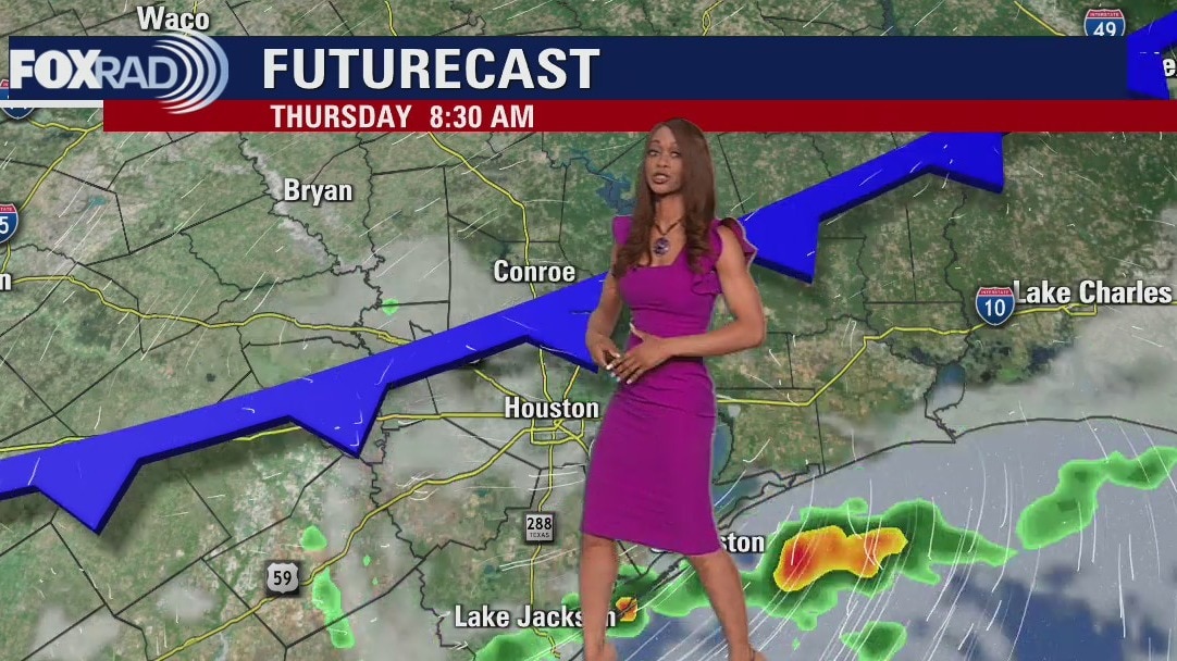
A weak front brought through isolated pockets of heavy rain this morning and will provide a slight decrease in temperatures and humidity. It looks to linger near the coast, which in conjunction with the sea breeze could spark up a few more isolated storms later this afternoon and evening mostly south of I-10. We'll be mainly dry to start the weekend with building humidity ahead of our second front, which brings much more promising rain chances at the start of next week. Plan for scattered showers and storms to return Sunday, and linger through most of the day Monday. After a soggy start to the work week, very pleasant crisp fall air drains in by midweek.
A weak front brought through isolated pockets of heavy rain this morning and will provide a slight decrease in temperatures and humidity. It looks to linger near the coast, which in conjunction with the sea breeze could spark up a few more isolated storms later this afternoon and evening mostly south of I-10. We'll be mainly dry to start the weekend with building humidity ahead of our second front, which brings much more promising rain chances at the start of next week. Plan for scattered showers and storms to return Sunday, and linger through most of the day Monday. After a soggy start to the work week, very pleasant crisp fall air drains in by midweek.
Humid start Thursday with some patchy fog and an isolated shower or storm
A weak front moving through the area today will provide a slight decrease in temperatures and humidity. As it works to slowly clear the coast, the sea breeze could spark up a few more isolated storms later this afternoon and evening mostly south of I-10. We'll be mainly dry to start the weekend with building humidity ahead of our second front, which brings much more promising rain chances at the start of next week. Plan for scattered showers and storms to return Sunday, and linger through most of the day Monday. After a soggy start to the work week, very pleasant crisp fall air drains in by midweek.
A weak front moving through the area today will provide a slight decrease in temperatures and humidity. As it works to slowly clear the coast, the sea breeze could spark up a few more isolated storms later this afternoon and evening mostly south of I-10. We'll be mainly dry to start the weekend with building humidity ahead of our second front, which brings much more promising rain chances at the start of next week. Plan for scattered showers and storms to return Sunday, and linger through most of the day Monday. After a soggy start to the work week, very pleasant crisp fall air drains in by midweek.
Thursday morning weather forecast
Weak cold front will roll into SE Texas tonight and spotty rain and a few storms will be possible. Right now, risk for severe storms is expected to stay to our NE but a few heavy downpours & rumbles of thunder are certainly possible. Rain should wind down Thursday with temperatures a few degrees cooler. A stronger fall cold front is set to arrive early next week that will usher in even cooler air and bring a better shot for rain and some thunderstorms. Tropical Storm Karl will make a turn to the the south over the next 24 hours and head towards the SE Mexican coast bringing the threat for flooding there.
Weak cold front will roll into SE Texas tonight and spotty rain and a few storms will be possible. Right now, risk for severe storms is expected to stay to our NE but a few heavy downpours & rumbles of thunder are certainly possible. Rain should wind down Thursday with temperatures a few degrees cooler. A stronger fall cold front is set to arrive early next week that will usher in even cooler air and bring a better shot for rain and some thunderstorms. Tropical Storm Karl will make a turn to the the south over the next 24 hours and head towards the SE Mexican coast bringing the threat for flooding there.
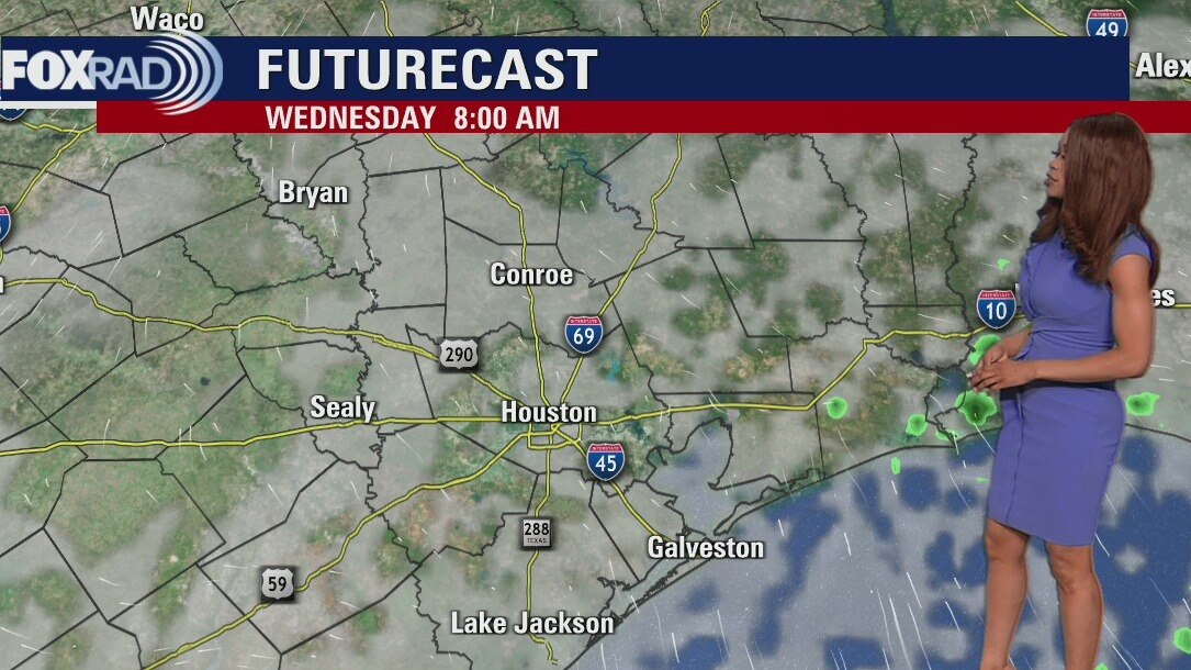
Spotty rain, a few storms this Wednesday afternoon
Weak cold front will roll into southeast Texas tonight and spotty rain and a few storms will be possible. Right now, the risk for severe storms is expected to stay to our northeast but a few heavy downpours & rumbles of thunder are certainly possible. Rain should wind down Thursday with temperatures a few degrees cooler. A stronger fall cold front is set to arrive early next week that will usher in even cooler air and bring a better shot for rain and some thunderstorms. Tropical Storm Karl will make a turn to the south over the next 24 hours and head towards the southeast Mexican coast bringing the threat of flooding there.
Weak cold front will roll into southeast Texas tonight and spotty rain and a few storms will be possible. Right now, the risk for severe storms is expected to stay to our northeast but a few heavy downpours & rumbles of thunder are certainly possible. Rain should wind down Thursday with temperatures a few degrees cooler. A stronger fall cold front is set to arrive early next week that will usher in even cooler air and bring a better shot for rain and some thunderstorms. Tropical Storm Karl will make a turn to the south over the next 24 hours and head towards the southeast Mexican coast bringing the threat of flooding there.
Wednesday afternoon weather forecast with Meteorologist John Dawson
Some areas around Houston could see a few showers Wednesday afternoon. A weak front will move through southeast Texas bringing another chance for rain tonight. Temperatures remain warm for October until a stronger arrives at the start of next week.
Some areas around Houston could see a few showers Wednesday afternoon. A weak front will move through southeast Texas bringing another chance for rain tonight. Temperatures remain warm for October until a stronger arrives at the start of next week.
Mild morning with patchy fog, warm Wednesday afternoon with isolated showers
Some areas around Houston could see a few showers Wednesday afternoon. A weak front will move through southeast Texas bringing another chance for rain tonight. Temperatures remain warm for October until a stronger one arrives at the start of next week.
Some areas around Houston could see a few showers Wednesday afternoon. A weak front will move through southeast Texas bringing another chance for rain tonight. Temperatures remain warm for October until a stronger one arrives at the start of next week.
Wednesday morning weather forecast
Tropical Storm Karl has formed in the southern Gulf of Mexico. Direct impacts from Karl are not expected but some moisture from Karl may stream into SE Texas over the next few days. A cold front will also approach from the north bringing a chance for spotty showers and storms Wednesday through early Thursday. That front will usher in slightly cooler temperatures late week. Then a stronger front moves in early next week with a better shot for rain and storms. That front will have it feeling a lot more like fall by next Tuesday.
Tropical Storm Karl has formed in the southern Gulf of Mexico. Direct impacts from Karl are not expected but some moisture from Karl may stream into SE Texas over the next few days. A cold front will also approach from the north bringing a chance for spotty showers and storms Wednesday through early Thursday. That front will usher in slightly cooler temperatures late week. Then a stronger front moves in early next week with a better shot for rain and storms. That front will have it feeling a lot more like fall by next Tuesday.

Tropical Storm Karl possibly bringing wet weather to SE Texas
Direct impacts from Tropical Storm Karl are not expected, but some moisture from Karl may stream into SE Texas over the next few days.
Direct impacts from Tropical Storm Karl are not expected, but some moisture from Karl may stream into SE Texas over the next few days.

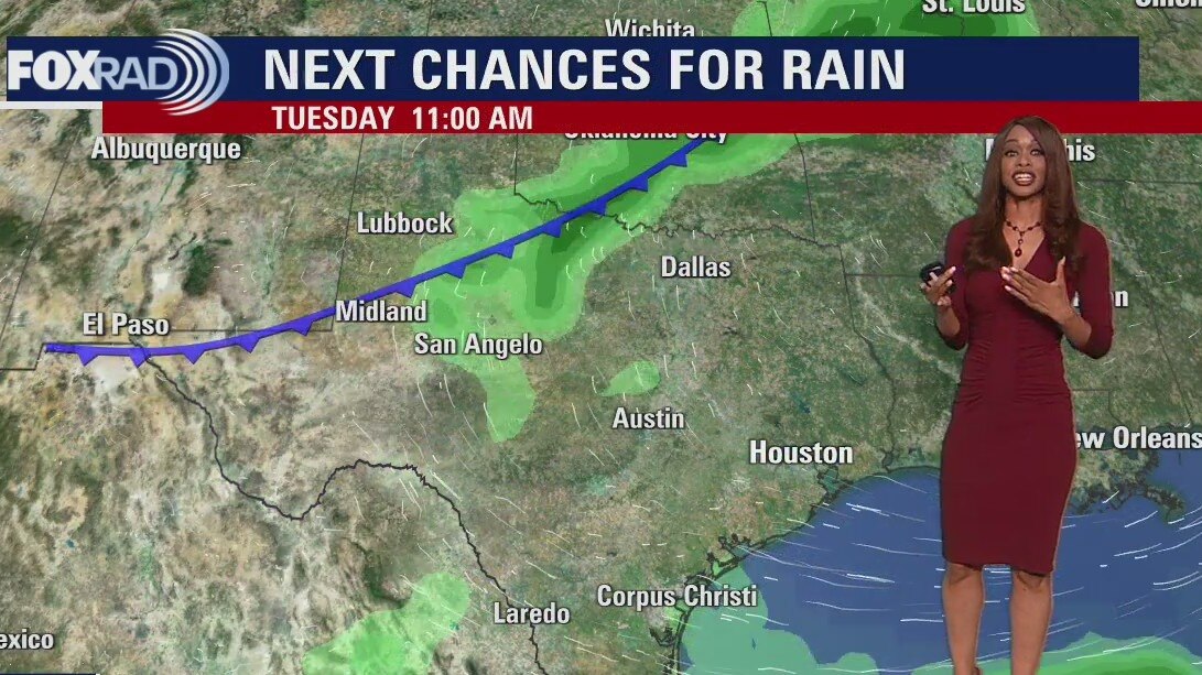
Tuesday 10/11 Weather Forecast
Tropical Storm Karl has formed in the southern Gulf of Mexico. Direct impacts from Karl are not expected but some moisture from Karl may stream into SE Texas over the next few days. A cold front will also approach from the north bringing a chance for spotty showers and storms Wednesday through early Thursday. That front will usher in slightly cooler temperatures late week. Then a stronger front moves in early next week with a better shot for rain and storms. That front will have it feeling a lot more like fall by next Tuesday.
Tropical Storm Karl has formed in the southern Gulf of Mexico. Direct impacts from Karl are not expected but some moisture from Karl may stream into SE Texas over the next few days. A cold front will also approach from the north bringing a chance for spotty showers and storms Wednesday through early Thursday. That front will usher in slightly cooler temperatures late week. Then a stronger front moves in early next week with a better shot for rain and storms. That front will have it feeling a lot more like fall by next Tuesday.

TRACER: What role does air quality play in thunderstorm development
Tracer project aims to improve weather forecasting.
Tracer project aims to improve weather forecasting.
Pleasant start Tuesday with increasing humidity and a warm afternoon
Look for another mild day in Houston on Tuesday. Increasing humidity will lead to partly cloudy skies and a warm afternoon. A weak front will move through southeast Texas late Wednesday into early Thursday morning. That front will not impact temperatures much but should bring a few showers. A stronger front arrives at the end of the weekend.
Look for another mild day in Houston on Tuesday. Increasing humidity will lead to partly cloudy skies and a warm afternoon. A weak front will move through southeast Texas late Wednesday into early Thursday morning. That front will not impact temperatures much but should bring a few showers. A stronger front arrives at the end of the weekend.
Tuesday morning weather forecast
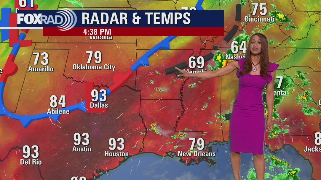
It's a beautiful start to the week with lots of sunshine and warm temperatures. Moisture will increase by Tuesday and Wednesday ahead of a weak cold front that arrives early Thursday. A 30-40% chance for showers will be with us Midweek. A stronger cold front arrives late Sunday into early Monday that could bring more widespread rain and a bigger drop in temperatures. Julia is no longer a tropical cyclone but is bringing heavy rain to parts of Guatemala and S. Mexico. Another disturbance over the Yucatan Peninsula has a low chance for development over the next few days.
It's a beautiful start to the week with lots of sunshine and warm temperatures. Moisture will increase by Tuesday and Wednesday ahead of a weak cold front that arrives early Thursday. A 30-40% chance for showers will be with us Midweek. A stronger cold front arrives late Sunday into early Monday that could bring more widespread rain and a bigger drop in temperatures. Julia is no longer a tropical cyclone but is bringing heavy rain to parts of Guatemala and S. Mexico. Another disturbance over the Yucatan Peninsula has a low chance for development over the next few days.