

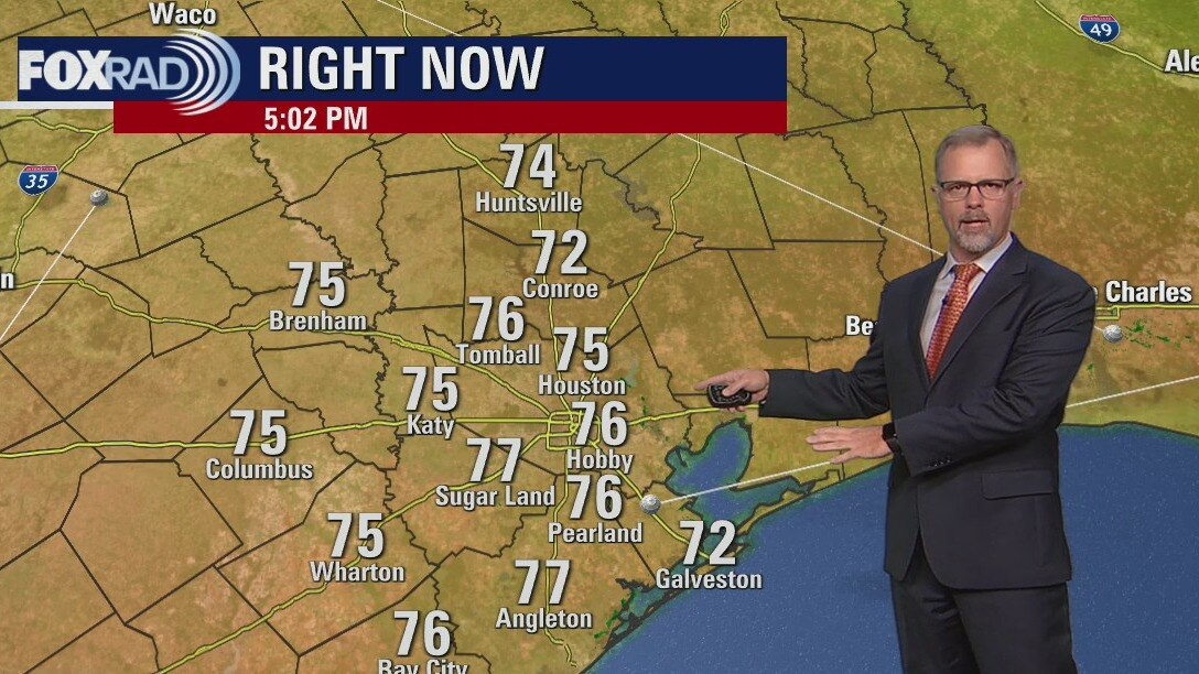
Breezy, warm Thursday afternoon with some showers
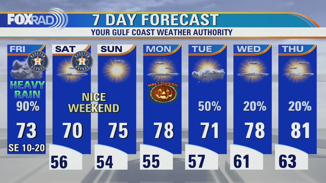
Warmth and humidity will be on the rise today and tomorrow as gulf breezes continue to funnel in rich moisture ahead of our next storm system. An elevated strong to severe storm risk exists to our north during the day Friday, with a more subdued version reaching us closer to midnight. Strong winds continue to be the primary concern locally that could lead to some isolated wind damage and power outages in the overnight hours. After a brief dose of heavy rain, frequent thunder, and lightning we're looking better for World Series Game 6 at home, though a few daily lighter showers may linger through Monday.
Warmth and humidity will be on the rise today and tomorrow as gulf breezes continue to funnel in rich moisture ahead of our next storm system. An elevated strong to severe storm risk exists to our north during the day Friday, with a more subdued version reaching us closer to midnight. Strong winds continue to be the primary concern locally that could lead to some isolated wind damage and power outages in the overnight hours. After a brief dose of heavy rain, frequent thunder, and lightning we're looking better for World Series Game 6 at home, though a few daily lighter showers may linger through Monday.


Houston Weather: Severe storms expected for Friday, possible tornadoes
Our winds, humidity and temperatures are trending higher for today and tomorrow with a gulf breeze kicking in. Now, we are still concerned about a line of severe storms on the way late Friday night that could bring high winds and brief heavy rain. Beyond that system, rain chances and temperatures will be lower for the weekend and Election Day.
Our winds, humidity and temperatures are trending higher for today and tomorrow with a gulf breeze kicking in. Now, we are still concerned about a line of severe storms on the way late Friday night that could bring high winds and brief heavy rain. Beyond that system, rain chances and temperatures will be lower for the weekend and Election Day.

Severe storms expected for Friday to bring lower temperatures for the weekend
Our winds, humidity and temperatures are trending higher for today and tomorrow with a gulf breeze kicking in. Now, we are still concerned about a line of severe storms on the way late Friday night that could bring high winds and brief heavy rain. Beyond that system, rain chances and temperatures will be lower for the weekend and Election Day.
Our winds, humidity and temperatures are trending higher for today and tomorrow with a gulf breeze kicking in. Now, we are still concerned about a line of severe storms on the way late Friday night that could bring high winds and brief heavy rain. Beyond that system, rain chances and temperatures will be lower for the weekend and Election Day.

Thursday morning weather forecast
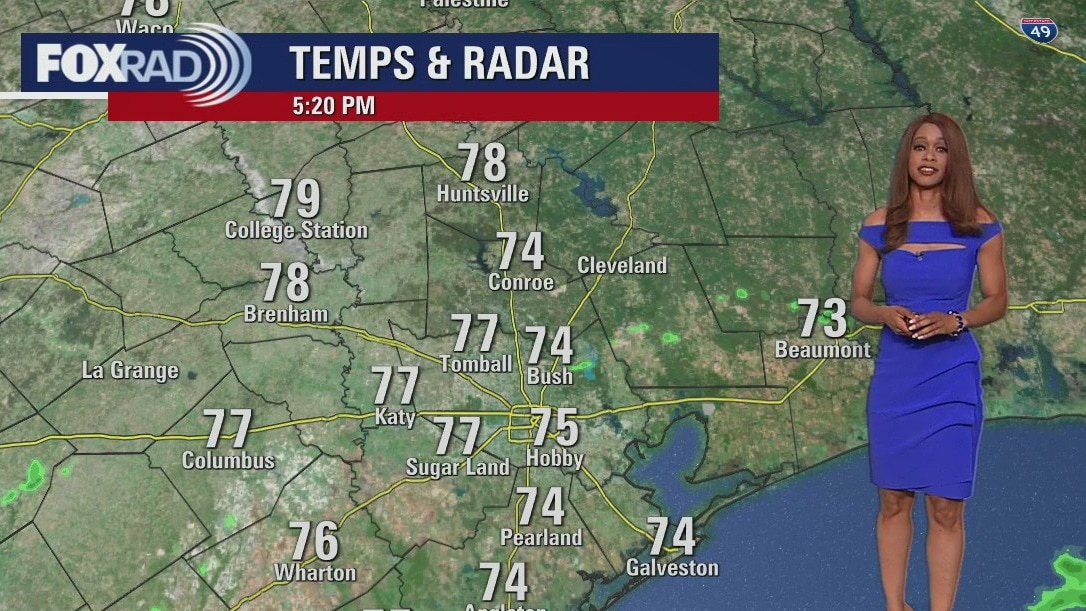
Locally, there might be a stray shower this evening but most should be dry. We are closely monitoring a developing storm system that will bring an increased Category 2 out of 5 severe threat to Houston late Friday through early Saturday. Main threat will be damaging winds but there will be a low tornado threat and some brief heavy rain. Highest severe threat will stay to the north of Houston. Weather should be quiet and cooler for much of the weekend but a few showers are expected to return Monday. In the tropics, Hurricane Lisa is making landfall in Belize and Hurricane Martin in the Atlantic is not expected to threaten land.
Locally, there might be a stray shower this evening but most should be dry. We are closely monitoring a developing storm system that will bring an increased Category 2 out of 5 severe threat to Houston late Friday through early Saturday. Main threat will be damaging winds but there will be a low tornado threat and some brief heavy rain. Highest severe threat will stay to the north of Houston. Weather should be quiet and cooler for much of the weekend but a few showers are expected to return Monday. In the tropics, Hurricane Lisa is making landfall in Belize and Hurricane Martin in the Atlantic is not expected to threaten land.
Mostly dry Wednesday evening with temps in the 70s
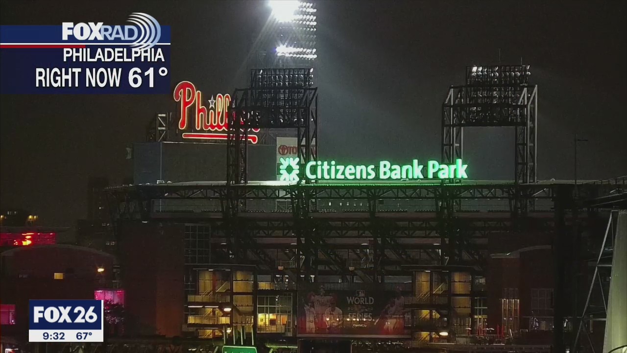
Weather looks cool and dry for Game 4 of the World Series at Citizens Bank Park in Philadelphia. Temperatures should stay in the 50s during the game. Locally, there might be a stray shower this evening but most should be dry. We are closely monitoring a developing storm system that will bring an increased Category 2 out of 5 severe threat to Houston late Friday through early Saturday. The main threat will be damaging winds but there will be a low tornado threat and some brief heavy rain. The highest severe threat will stay to the north of Houston. Weather should be quiet and cooler for much of the weekend but a few showers are expected to return Monday. In the tropics, Hurricane Lisa is making landfall in Belize and Hurricane Martin in the Atlantic is not expected to threaten land.
Weather looks cool and dry for Game 4 of the World Series at Citizens Bank Park in Philadelphia. Temperatures should stay in the 50s during the game. Locally, there might be a stray shower this evening but most should be dry. We are closely monitoring a developing storm system that will bring an increased Category 2 out of 5 severe threat to Houston late Friday through early Saturday. The main threat will be damaging winds but there will be a low tornado threat and some brief heavy rain. The highest severe threat will stay to the north of Houston. Weather should be quiet and cooler for much of the weekend but a few showers are expected to return Monday. In the tropics, Hurricane Lisa is making landfall in Belize and Hurricane Martin in the Atlantic is not expected to threaten land.

Some sun, possible light showers this Wednesday afternoon
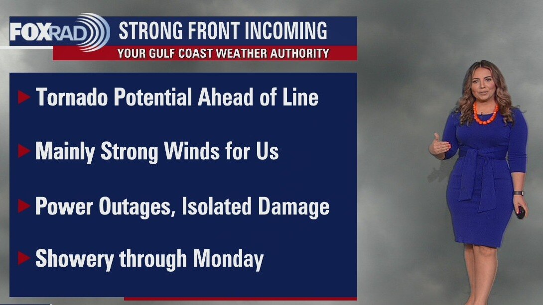
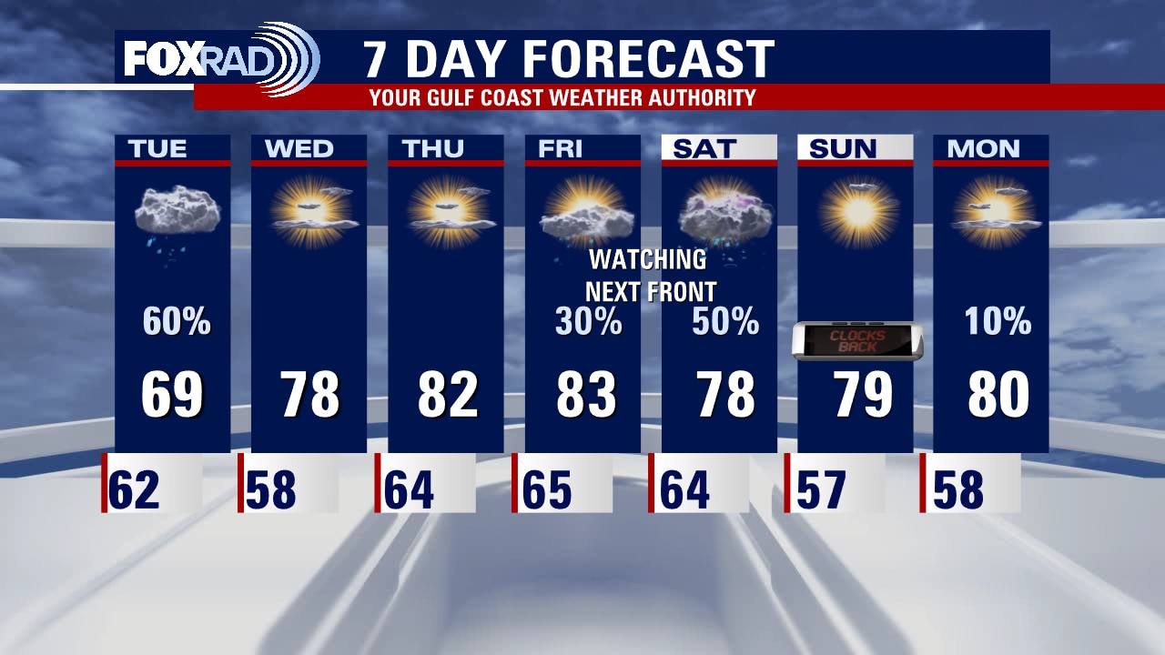
We're in for a couple of relatively quiet weather days to close out the work week, with a passing light shower or two possible. The weekend will begin with a line of potent storms, that looks to arrive locally overnight Friday into Saturday. Strong winds are currently the primary threat for southeast Texas, likely causing power outages and the potential for some isolated wind damage. The line does look to move through fairly quickly, limiting flooding concerns. Nonetheless, frequent thunder and lightning in addition to brief heavy rainfall can also be expected. Stay tuned in to the forecast for updates and changes, conditions can also be monitored via our free Fox 26 Weather App.
We're in for a couple of relatively quiet weather days to close out the work week, with a passing light shower or two possible. The weekend will begin with a line of potent storms, that looks to arrive locally overnight Friday into Saturday. Strong winds are currently the primary threat for southeast Texas, likely causing power outages and the potential for some isolated wind damage. The line does look to move through fairly quickly, limiting flooding concerns. Nonetheless, frequent thunder and lightning in addition to brief heavy rainfall can also be expected. Stay tuned in to the forecast for updates and changes, conditions can also be monitored via our free Fox 26 Weather App.

Cool Wednesday morning with areas of fog and mist, then mostly cloudy skies
After a foggy morning, today is looking mostly cloudy with a few light drizzles possible, otherwise a decent Wednesday. Tomorrow and Friday will be warmer as we watch and wait for a line of strong storms to sweep through late Friday or early Saturday. There will be a chance for severe winds when this line hits, so check back for updates over the next couple of days.
After a foggy morning, today is looking mostly cloudy with a few light drizzles possible, otherwise a decent Wednesday. Tomorrow and Friday will be warmer as we watch and wait for a line of strong storms to sweep through late Friday or early Saturday. There will be a chance for severe winds when this line hits, so check back for updates over the next couple of days.

Wednesday morning weather forecast
Expect the rain to finally start to wind down tonight in Houston as a disturbance pulls away. Weather should be quiet also for Game 3 of the World Series at Citizens Bank Park in Philadelphia with temperatures starting off in the low 60s. We get a few mild and dry days. But a stronger system arrives late Friday and Saturday which will bring another round of rain and possibly some strong storms. Tropical Storm Lisa is expected to strengthen to a hurricane tonight and make landfall around Belize Wednesday afternoon. Tropical Storm Martin is in the north central Atlantic and is only expected to impact shipping channels.
Expect the rain to finally start to wind down tonight in Houston as a disturbance pulls away. Weather should be quiet also for Game 3 of the World Series at Citizens Bank Park in Philadelphia with temperatures starting off in the low 60s. We get a few mild and dry days. But a stronger system arrives late Friday and Saturday which will bring another round of rain and possibly some strong storms. Tropical Storm Lisa is expected to strengthen to a hurricane tonight and make landfall around Belize Wednesday afternoon. Tropical Storm Martin is in the north central Atlantic and is only expected to impact shipping channels.

Tuesday evening weather forecast with Meteorologist Remeisha Shade
It's drying out in Philly for World Series Game 3 but we have been dealing with rain across SE Texas much of the day. Expect the rain to finally start to wind down tonight in Houston as a disturbance pulls away. Weather should be quiet also for Game 3 of the World Series at Citizens Bank Park in Philadelphia with temperatures starting off in the low 60s. We get a few mild and dry days. But a stronger system arrives late Friday and Saturday which will bring another round of rain and possibly some strong storms. Tropical Storm Lisa is expected to strengthen to a hurricane tonight and make landfall around Belize Wednesday afternoon. Tropical Storm Martin is in the north central Atlantic and is only expected to impact shipping channels.
It's drying out in Philly for World Series Game 3 but we have been dealing with rain across SE Texas much of the day. Expect the rain to finally start to wind down tonight in Houston as a disturbance pulls away. Weather should be quiet also for Game 3 of the World Series at Citizens Bank Park in Philadelphia with temperatures starting off in the low 60s. We get a few mild and dry days. But a stronger system arrives late Friday and Saturday which will bring another round of rain and possibly some strong storms. Tropical Storm Lisa is expected to strengthen to a hurricane tonight and make landfall around Belize Wednesday afternoon. Tropical Storm Martin is in the north central Atlantic and is only expected to impact shipping channels.

Off and on showers and a few storms throughout the day
Just like Game 3 of the World Series yesterday, today's forecast here is a washout. Expect a blanket of rain this morning and scattered showers and storms through the day. Flooding or severe weather aren't likely, but it is going to be a nuisance. Wednesday and Thursday look quiet, but severe storms are possible in Texas late Friday.
Just like Game 3 of the World Series yesterday, today's forecast here is a washout. Expect a blanket of rain this morning and scattered showers and storms through the day. Flooding or severe weather aren't likely, but it is going to be a nuisance. Wednesday and Thursday look quiet, but severe storms are possible in Texas late Friday.
Tuesday morning weather forecast
Weather should be mainly a treat for all the trick-or-treaters this evening across SE Texas. Look for temperatures to fall into the 60s tonight with with light wind. There's a very small chance of a few showers, mainly late. A much better chance for rain and maybe a few rumbles of thunder returns Tuesday with highs near 70. Weather for the Astros & Phillies Game 3 tonight in Philly could be tricky with a 50-70% chance for showers throughout the game. That could lead to a few delays or possibly a postponed game. Tropics are active again with Tropical Storm Lisa in the central Caribbean headed towards Central America by Wednesday.
Weather should be mainly a treat for all the trick-or-treaters this evening across SE Texas. Look for temperatures to fall into the 60s tonight with with light wind. There's a very small chance of a few showers, mainly late. A much better chance for rain and maybe a few rumbles of thunder returns Tuesday with highs near 70. Weather for the Astros & Phillies Game 3 tonight in Philly could be tricky with a 50-70% chance for showers throughout the game. That could lead to a few delays or possibly a postponed game. Tropics are active again with Tropical Storm Lisa in the central Caribbean headed towards Central America by Wednesday.
Halloween evening weather forecast with Meteorologist Remeisha Shade
Weather should be mainly a treat for all the trick-or-treaters this evening across SE Texas. Look for temperatures to fall into the 60s tonight with with light wind. There's a very small chance of a few showers, mainly late. A much better chance for rain and maybe a few rumbles of thunder returns Tuesday with highs near 70. Weather for the Astros & Phillies Game 3 tonight in Philly could be tricky with a 50-70% chance for showers throughout the game. That could lead to a few delays or possibly a postponed game. Tropics are active again with Tropical Storm Lisa in the central Caribbean headed towards Central America by Wednesday.
Weather should be mainly a treat for all the trick-or-treaters this evening across SE Texas. Look for temperatures to fall into the 60s tonight with with light wind. There's a very small chance of a few showers, mainly late. A much better chance for rain and maybe a few rumbles of thunder returns Tuesday with highs near 70. Weather for the Astros & Phillies Game 3 tonight in Philly could be tricky with a 50-70% chance for showers throughout the game. That could lead to a few delays or possibly a postponed game. Tropics are active again with Tropical Storm Lisa in the central Caribbean headed towards Central America by Wednesday.

Halloween forecast: Chilly morning, then partly cloudy with highs in the 70s
Weather is looking "boo-tiful" for trick or treating tonight with a rare, quiet and mild forecast. Temperatures will run in the upper 60s and low 70s with no rain expected. Showers will return tomorrow with isolated storms possible. Weather in Philadelphia for game 3 of the World Series on Fox 26 includes the chance for light rain, so some rain delays are possible.
Weather is looking "boo-tiful" for trick or treating tonight with a rare, quiet and mild forecast. Temperatures will run in the upper 60s and low 70s with no rain expected. Showers will return tomorrow with isolated storms possible. Weather in Philadelphia for game 3 of the World Series on Fox 26 includes the chance for light rain, so some rain delays are possible.
Warm, slight winds with temps in the 70s Sunday evening
It's great when the Halloween forecast is not spooky. Look for more treats than tricks concerning the weather in Houston. Temperatures will be mild with only a very few isolated showers popping up very late across Southeast Texas. Tuesday will bring showers along the coast with some finding their way inland as well. The next front will arrive late in the week and bring more rain with cooler temperatures for the weekend.
It's great when the Halloween forecast is not spooky. Look for more treats than tricks concerning the weather in Houston. Temperatures will be mild with only a very few isolated showers popping up very late across Southeast Texas. Tuesday will bring showers along the coast with some finding their way inland as well. The next front will arrive late in the week and bring more rain with cooler temperatures for the weekend.

Sunday Morning Forecast with Meteorologist Lena Maria Arango
The last weekend in October ends on a pleasant note, with a dry and mild start to the workweek. Trick 'o treaters can expect partly cloudy skies and low 70s in the evening, with a few spotty showers rolling in late. Two systems bring us rain chances locally this week, the first an area of low pressure Tuesday which looks to keep most of the moisture out over the gulf. There are early signs of a potentially more potent front arriving to Texas by the weekend, so we'll be watching closely to see if that may impact us. Meanwhile, our Astros and a cold front head to Philly... which looks to spell trouble for Monday night's game.
The last weekend in October ends on a pleasant note, with a dry and mild start to the workweek. Trick 'o treaters can expect partly cloudy skies and low 70s in the evening, with a few spotty showers rolling in late. Two systems bring us rain chances locally this week, the first an area of low pressure Tuesday which looks to keep most of the moisture out over the gulf. There are early signs of a potentially more potent front arriving to Texas by the weekend, so we'll be watching closely to see if that may impact us. Meanwhile, our Astros and a cold front head to Philly... which looks to spell trouble for Monday night's game.
Breezy and cool Saturday evening with little to no rain
Sunday will see more of a return to the sunshine to wrap up the weekend in Houston. Halloween activities should be free of rain this year. Monday calls for milder temperatures and partly cloudy skies. A warm front will creep up the gulf coast from the south and bring rain chances back to the forecast on Tuesday. Temperatures continue to warm as we progress through the week.
Sunday will see more of a return to the sunshine to wrap up the weekend in Houston. Halloween activities should be free of rain this year. Monday calls for milder temperatures and partly cloudy skies. A warm front will creep up the gulf coast from the south and bring rain chances back to the forecast on Tuesday. Temperatures continue to warm as we progress through the week.

Saturday Morning Forecast with Meteorologist Lena Maria Arango
Today we transition to drier conditions, aside from a slim but non-zero chance of a sprinkle in the far north and eastern extents of our viewing area. Partly-mostly cloudy skies will keep temperatures on the cool side, with many only maxing out in the 60s to near 70. Warmer and sunnier to close out the weekend and for Halloween, with a couple of local rain chances for next week. Speaking of rain, while Halloween in Houston will be a treat, playing ball in Philly for game 3 of the World Series is looking tricky. As the front that brought us a round of heavy rain on Friday advances east, there's a high probability of a rain delay or postponement.
Today we transition to drier conditions, aside from a slim but non-zero chance of a sprinkle in the far north and eastern extents of our viewing area. Partly-mostly cloudy skies will keep temperatures on the cool side, with many only maxing out in the 60s to near 70. Warmer and sunnier to close out the weekend and for Halloween, with a couple of local rain chances for next week. Speaking of rain, while Halloween in Houston will be a treat, playing ball in Philly for game 3 of the World Series is looking tricky. As the front that brought us a round of heavy rain on Friday advances east, there's a high probability of a rain delay or postponement.
Saturday morning weather forecast
Showers and storms are rolling across SE Texas this afternoon as a cold front crosses the area. Severe threat is now lower, but a brief wind gust near 50 mph is still possible. Rounds of heavy rain could also lead to some flooding issues. Make sure to slow things down as traffic will be extra crazy with all the action surrounding World Series Game #1 at Minute Maid Park. First Pitch is at 7:03 pm and there will still be some spotty showers around with rain finally winding down late tonight. Game 2 of the World Series on Saturday will feature pleasant temperatures and dry weather. Halloween weather will be a treat also with no major storm system expected Monday evening.
Showers and storms are rolling across SE Texas this afternoon as a cold front crosses the area. Severe threat is now lower, but a brief wind gust near 50 mph is still possible. Rounds of heavy rain could also lead to some flooding issues. Make sure to slow things down as traffic will be extra crazy with all the action surrounding World Series Game #1 at Minute Maid Park. First Pitch is at 7:03 pm and there will still be some spotty showers around with rain finally winding down late tonight. Game 2 of the World Series on Saturday will feature pleasant temperatures and dry weather. Halloween weather will be a treat also with no major storm system expected Monday evening.
Expect rounds of rain, a few storms this Friday afternoon
Rounds of rain and a few strong to severe storms will continue through this evening. Stay weather aware and tuned into FOX 26 Houston as we help you navigate through any problem spots that may arise. World Series Game 1 coverage begins only on Fox at 5 p.m., with showers and storms gradually waning into the overnight hours. Saturday is a bit of a transition day but conditions are looking much better for Game 2 through Halloween. We’ll have to continue to monitor this system as it marches east, as it may impact away games in Philly next week.
Rounds of rain and a few strong to severe storms will continue through this evening. Stay weather aware and tuned into FOX 26 Houston as we help you navigate through any problem spots that may arise. World Series Game 1 coverage begins only on Fox at 5 p.m., with showers and storms gradually waning into the overnight hours. Saturday is a bit of a transition day but conditions are looking much better for Game 2 through Halloween. We’ll have to continue to monitor this system as it marches east, as it may impact away games in Philly next week.
Rain and storms expected Friday
Rounds of rain and a few strong to severe storms will roll through southeast Texas, mainly mid-morning through mid-afternoon. Stay weather aware and tuned into FOX 26 Houston as we help you navigate through any problem spots that may arise throughout the day. World Series game 1 coverage begins only on Fox at 5 p.m., with showers and storms gradually waning into the overnight hours. Saturday is a bit of a transition day but conditions are looking much better for game 2 through Halloween. We?ll have to continue to monitor this system as it marches east, as it may impact away games in Philly next week.
Rounds of rain and a few strong to severe storms will roll through southeast Texas, mainly mid-morning through mid-afternoon. Stay weather aware and tuned into FOX 26 Houston as we help you navigate through any problem spots that may arise throughout the day. World Series game 1 coverage begins only on Fox at 5 p.m., with showers and storms gradually waning into the overnight hours. Saturday is a bit of a transition day but conditions are looking much better for game 2 through Halloween. We?ll have to continue to monitor this system as it marches east, as it may impact away games in Philly next week.