

Tuesday morning weather forecast
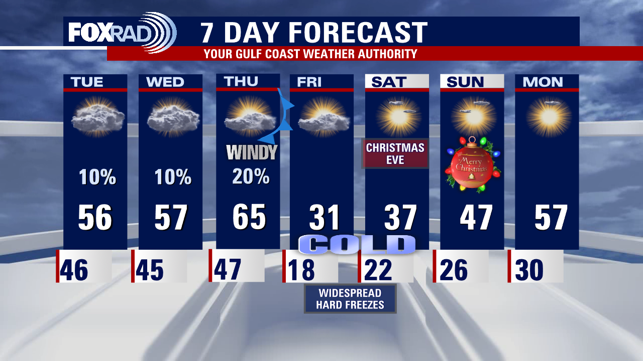
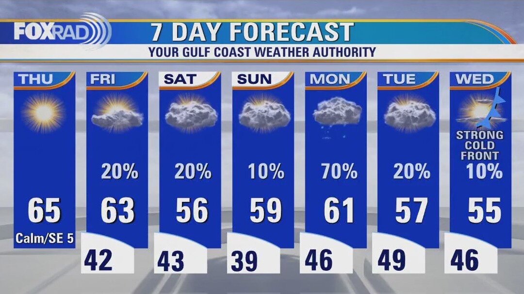
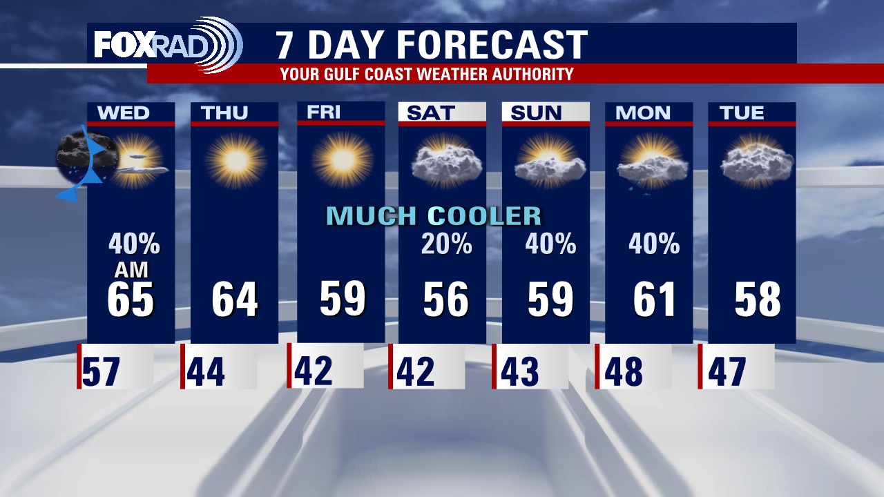
Huge changes are on the way this week leading up to the Christmas holiday this Sunday! You will have two cool but mainly quiet days to prepare for upcoming freezing conditions later this week. Next few days should be mainly dry with only a slim chance of a shower and highs in the 50s. Temps will briefly soar to the 60s on Thursday ahead of a strong arctic cold front that will send temperatures CRASHING by Thursday evening. In fact, we will end up in the teens by Thursday night and likely remain below freezing Friday and early Saturday! Remember to protect yourself with extra layers, cover plants, cover/wrap pipes and make sure your pets are warm also. Christmas day temps will be warmer but still well below normal climbing to the 40s by Sunday afternoon. We finally start to crawl out of the chill early next week with highs near 60 by Monday. Prepare now to stay safe in the cold!
Huge changes are on the way this week leading up to the Christmas holiday this Sunday! You will have two cool but mainly quiet days to prepare for upcoming freezing conditions later this week. Next few days should be mainly dry with only a slim chance of a shower and highs in the 50s. Temps will briefly soar to the 60s on Thursday ahead of a strong arctic cold front that will send temperatures CRASHING by Thursday evening. In fact, we will end up in the teens by Thursday night and likely remain below freezing Friday and early Saturday! Remember to protect yourself with extra layers, cover plants, cover/wrap pipes and make sure your pets are warm also. Christmas day temps will be warmer but still well below normal climbing to the 40s by Sunday afternoon. We finally start to crawl out of the chill early next week with highs near 60 by Monday. Prepare now to stay safe in the cold!
Huge changes are on the way this week leading up to the Christmas holiday this Sunday!
You will have two cool but mainly quiet days to prepare for upcoming freezing conditions later this week. The next few days should be mainly dry with only a slim chance of a shower and highs in the 50s. Temps will briefly soar to the 60s on Thursday ahead of a strong arctic cold front that will send temperatures CRASHING by Thursday evening. In fact, we will end up in the teens by Thursday night and likely remain below-freezing Friday and early Saturday! Remember to protect yourself with extra layers, cover plants, cover/wrap pipes and make sure your pets are warm also. Christmas day temps will be warmer but still well below normal climbing to the 40s by Sunday afternoon. We finally start to crawl out of the chill early next week with highs near 60 by Monday. Prepare now to stay safe in the cold!
You will have two cool but mainly quiet days to prepare for upcoming freezing conditions later this week. The next few days should be mainly dry with only a slim chance of a shower and highs in the 50s. Temps will briefly soar to the 60s on Thursday ahead of a strong arctic cold front that will send temperatures CRASHING by Thursday evening. In fact, we will end up in the teens by Thursday night and likely remain below-freezing Friday and early Saturday! Remember to protect yourself with extra layers, cover plants, cover/wrap pipes and make sure your pets are warm also. Christmas day temps will be warmer but still well below normal climbing to the 40s by Sunday afternoon. We finally start to crawl out of the chill early next week with highs near 60 by Monday. Prepare now to stay safe in the cold!
Rainy, chilly Monday
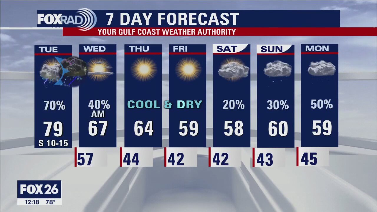
Not the best start to the week as a coastal low brings rainy, chilly, breezy conditions. But, today will feel like paradise compared to the end of the week. Tuesday and Wednesday will be cloudy, cool but mostly dry for Christmas and 4 P's prep. Thursday will be a bit of a wild ride, as depending on the timing of the front the coast could near 70 while inland locations get stuck in the 50s. Gusty winds will rapidly drive down temps wind chills and could cause isolated power outages. As a Christmas present, we should finally get above 40 by Sunday.
Not the best start to the week as a coastal low brings rainy, chilly, breezy conditions. But, today will feel like paradise compared to the end of the week. Tuesday and Wednesday will be cloudy, cool but mostly dry for Christmas and 4 P's prep. Thursday will be a bit of a wild ride, as depending on the timing of the front the coast could near 70 while inland locations get stuck in the 50s. Gusty winds will rapidly drive down temps wind chills and could cause isolated power outages. As a Christmas present, we should finally get above 40 by Sunday.
Mostly cloudy, dry Sunday evening in the 50s
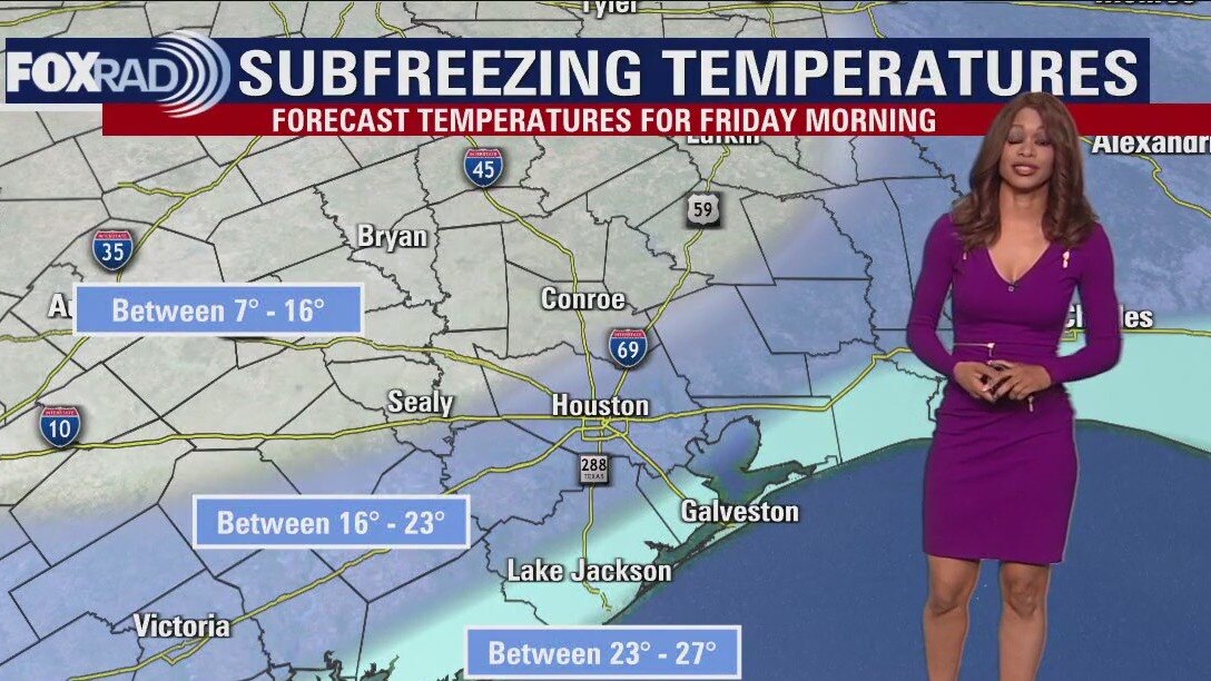
This week's forecast is still on track to start off wet and end cold, VERY COLD. Showers start spreading from the coast towards downtown Houston early Monday and continue for most of the day. The middle of the week looks cool and dry with the strong Arctic Front arriving Thursday afternoon. A widespread Hard Freeze (temperatures below 25 degrees) hits southeast Texas Friday morning and possibly Saturday morning. Christmas Day could start below freezing but will warm up to the mid-40s in the afternoon.
This week's forecast is still on track to start off wet and end cold, VERY COLD. Showers start spreading from the coast towards downtown Houston early Monday and continue for most of the day. The middle of the week looks cool and dry with the strong Arctic Front arriving Thursday afternoon. A widespread Hard Freeze (temperatures below 25 degrees) hits southeast Texas Friday morning and possibly Saturday morning. Christmas Day could start below freezing but will warm up to the mid-40s in the afternoon.
Partly cloudy, chilly Saturday evening in the 50s
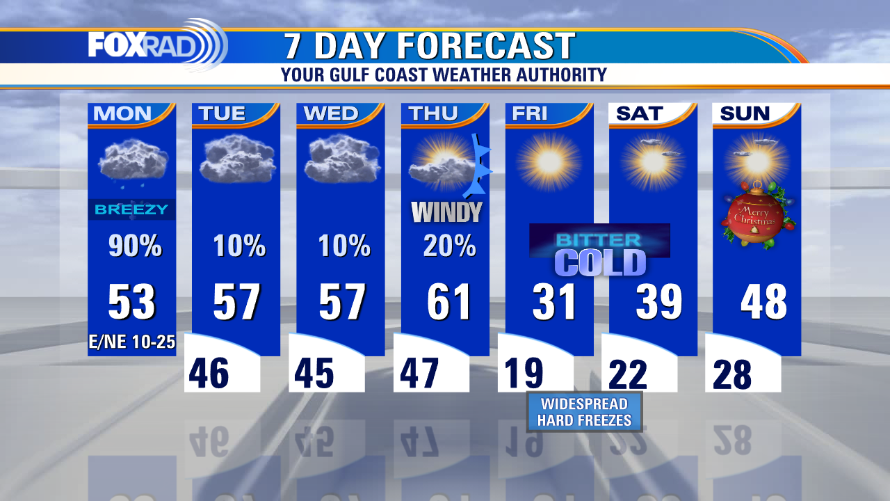
The rest of the weekend looks cold but overall pleasant for southeast Texas. A coastal low will bring showers and isolated heavy downpours for Houston and surrounding areas on Monday. The arctic cold front is still on track to bring widespread, prolonged freezing temperatures starting on Thursday night. Now is a good time to start preparing for these cold days and nights.
The rest of the weekend looks cold but overall pleasant for southeast Texas. A coastal low will bring showers and isolated heavy downpours for Houston and surrounding areas on Monday. The arctic cold front is still on track to bring widespread, prolonged freezing temperatures starting on Thursday night. Now is a good time to start preparing for these cold days and nights.

Saturday weather forecast with Meteorologist Lena Maria Arango
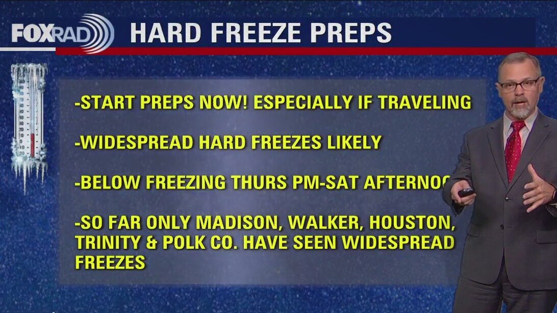
Good news for the last weekend before Christmas, which is always a busy one! Aside from seasonably cold temperatures, the weather will be quiet and cooperative. Monday is a washout pretty much start to finish, so allow for extra time to get around town. Midweek will be quiet, but a strong cold front will drag down a potent dose of arctic air on Thursday. Once we fall below freezing Thursday night, many locations may not rise above that until Saturday afternoon. Think ahead and begin hard freeze preps now, especially if you'll be out of town during that time period.
Good news for the last weekend before Christmas, which is always a busy one! Aside from seasonably cold temperatures, the weather will be quiet and cooperative. Monday is a washout pretty much start to finish, so allow for extra time to get around town. Midweek will be quiet, but a strong cold front will drag down a potent dose of arctic air on Thursday. Once we fall below freezing Thursday night, many locations may not rise above that until Saturday afternoon. Think ahead and begin hard freeze preps now, especially if you'll be out of town during that time period.
Saturday morning weather forecast
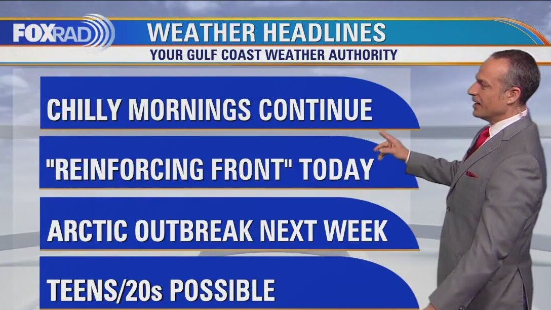
Spotty rain is possible this evening and tonight as a reinforcing front moves through the area. Rain should taper off tonight with just a slim shot for an isolated shower over the weekend. It will be cooler this weekend with highs in the 50s and overnight lows in the 30s and 40s. In fact, some of you may get close to freezing by Sunday morning. At least the weekend is mainly dry before widespread rain returns for Monday. Big story next week leading up to Christmas will be the major cold blast expected with a strong front Thursday. That means a widespread hard freeze likely by next Friday morning and temps about 30 degrees below normal Friday afternoon! Prepare now for the expected freezing conditions! Protect your pipes, plants, pets and of course yourself and loved ones!
Spotty rain is possible this evening and tonight as a reinforcing front moves through the area. Rain should taper off tonight with just a slim shot for an isolated shower over the weekend. It will be cooler this weekend with highs in the 50s and overnight lows in the 30s and 40s. In fact, some of you may get close to freezing by Sunday morning. At least the weekend is mainly dry before widespread rain returns for Monday. Big story next week leading up to Christmas will be the major cold blast expected with a strong front Thursday. That means a widespread hard freeze likely by next Friday morning and temps about 30 degrees below normal Friday afternoon! Prepare now for the expected freezing conditions! Protect your pipes, plants, pets and of course yourself and loved ones!
Cool, with a few showers Friday evening in the 60s
Spotty rain is possible this evening and tonight as a reinforcing front moves through the area. Rain should taper off tonight with just a slim shot for an isolated shower over the weekend. It will be cooler this weekend with highs in the 50s and overnight lows in the 30s and 40s. In fact, some of you may get close to freezing by Sunday morning. At least the weekend is mainly dry before widespread rain returns for Monday. Big story next week leading up to Christmas will be the major cold blast expected with a strong front Thursday. That means a widespread hard freeze likely by next Friday morning and temps about 30 degrees below normal Friday afternoon! Prepare now for the expected freezing conditions! Protect your pipes, plants, pets, and of course yourself and loved ones!
Spotty rain is possible this evening and tonight as a reinforcing front moves through the area. Rain should taper off tonight with just a slim shot for an isolated shower over the weekend. It will be cooler this weekend with highs in the 50s and overnight lows in the 30s and 40s. In fact, some of you may get close to freezing by Sunday morning. At least the weekend is mainly dry before widespread rain returns for Monday. Big story next week leading up to Christmas will be the major cold blast expected with a strong front Thursday. That means a widespread hard freeze likely by next Friday morning and temps about 30 degrees below normal Friday afternoon! Prepare now for the expected freezing conditions! Protect your pipes, plants, pets, and of course yourself and loved ones!
Cloudy Friday afternoon with light, spotty showers
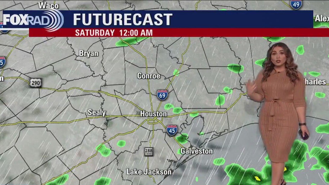
A few showers will be around tonight into tomorrow, and then the weekend is looking mostly dry but chilly. Sunday morning will be cold, keep that in mind if you'll be tailgating for the Texans or out and about early. Late Sunday through early Tuesday widespread rain is expected as a coastal low move across the area. Then get ready for a serious dose of cold air behind our next front, which will be dry but strong enough to pull in a blustery shot of north pole air just in time for Christmas.
A few showers will be around tonight into tomorrow, and then the weekend is looking mostly dry but chilly. Sunday morning will be cold, keep that in mind if you'll be tailgating for the Texans or out and about early. Late Sunday through early Tuesday widespread rain is expected as a coastal low move across the area. Then get ready for a serious dose of cold air behind our next front, which will be dry but strong enough to pull in a blustery shot of north pole air just in time for Christmas.
Friday weather forecast
Our weather is going to give us a bumpy ride over the next two weeks, so get ready. Watch for a few light showers today and tomorrow with seasonably cool temps. Some areas could reach the low 30s Sunday morning. Monday looks like a washout, then we turn our attention to an arctic blast that will move into the US for the middle of next week which could bring us the coldest air since the big freeze of 2021.
Our weather is going to give us a bumpy ride over the next two weeks, so get ready. Watch for a few light showers today and tomorrow with seasonably cool temps. Some areas could reach the low 30s Sunday morning. Monday looks like a washout, then we turn our attention to an arctic blast that will move into the US for the middle of next week which could bring us the coldest air since the big freeze of 2021.
Friday morning weather forecast
Weather looks cool and dry tonight with most areas dipping to the 40s and 50s closer to the coast. A few temperature readings in the 30s can't be ruled out up north. Friday looks pleasant by the afternoon with highs in the 60s. Weekend will be cool with just isolated showers. But look for a coastal low to bring widespread rain on Monday. Much stronger cold front arrives late next week by Thursday that will send temperatures plummeting just in time for the Christmas. First widespread freeze of the season is likely coming next Thursday night! Get ready!
Weather looks cool and dry tonight with most areas dipping to the 40s and 50s closer to the coast. A few temperature readings in the 30s can't be ruled out up north. Friday looks pleasant by the afternoon with highs in the 60s. Weekend will be cool with just isolated showers. But look for a coastal low to bring widespread rain on Monday. Much stronger cold front arrives late next week by Thursday that will send temperatures plummeting just in time for the Christmas. First widespread freeze of the season is likely coming next Thursday night! Get ready!
Calm, quiet, but oh-so chilly Thursday evening
Weather looks cool and dry tonight with most areas dipping to the 40s and 50s closer to the coast. A few temperature readings in the 30s can't be ruled out up north. Friday looks pleasant by the afternoon with highs in the 60s. Weekend will be cool with just isolated showers. But look for a coastal low to bring widespread rain on Monday. Much stronger cold front arrives late next week by Thursday that will send temperatures plummeting just in time for the Christmas. First widespread freeze of the season is likely coming next Thursday night! Get ready!
Weather looks cool and dry tonight with most areas dipping to the 40s and 50s closer to the coast. A few temperature readings in the 30s can't be ruled out up north. Friday looks pleasant by the afternoon with highs in the 60s. Weekend will be cool with just isolated showers. But look for a coastal low to bring widespread rain on Monday. Much stronger cold front arrives late next week by Thursday that will send temperatures plummeting just in time for the Christmas. First widespread freeze of the season is likely coming next Thursday night! Get ready!
Cool, chilly Thursday afternoon in the 60s
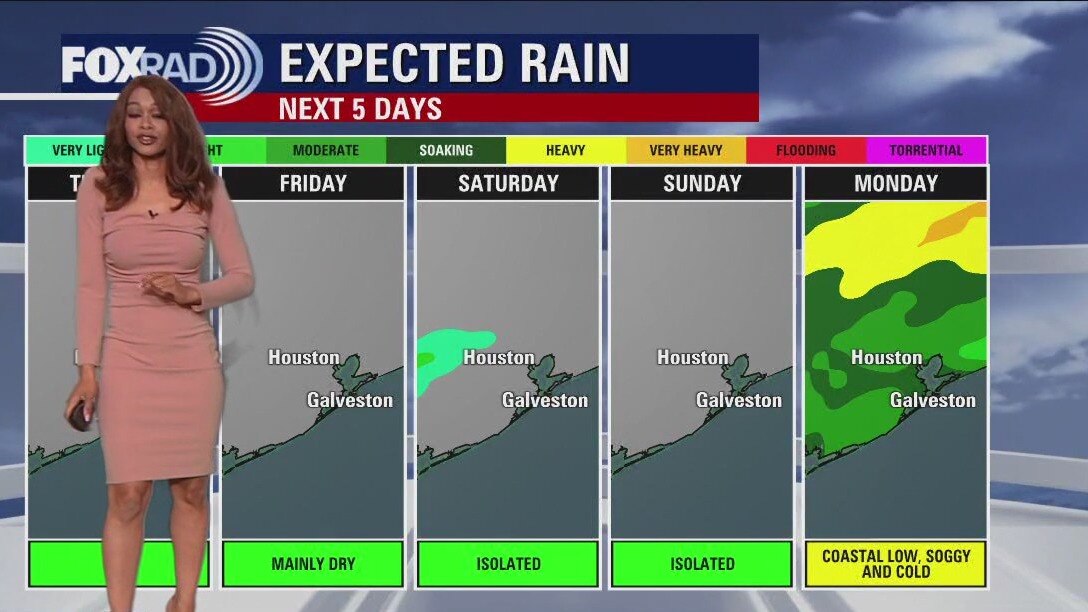
Cold mornings and cool afternoons will be the norm across southeast Texas this week. It will be good practice for the next shot of colder air that will drain in behind a stronger front late next week. Plan for a very chilly Christmas locally! Sunday night through Tuesday morning also looks fairly soggy, with a steady blanket of light to moderate rain courtesy of a coastal low. A few light and spotty showers are also possible overnight Friday as we head into the weekend, but the afternoons look mostly dry if you'll be out and about!
Cold mornings and cool afternoons will be the norm across southeast Texas this week. It will be good practice for the next shot of colder air that will drain in behind a stronger front late next week. Plan for a very chilly Christmas locally! Sunday night through Tuesday morning also looks fairly soggy, with a steady blanket of light to moderate rain courtesy of a coastal low. A few light and spotty showers are also possible overnight Friday as we head into the weekend, but the afternoons look mostly dry if you'll be out and about!
Clear and cold Thursday morning, then sunny, cool and dry
Seasonable December air has arrived in Houston and it looks like even colder air is on the way just before Christmas. Today looks nice with cool, dry air and highs in the 60s. Clouds return Friday through the weekend with chilly highs below 60 inland. Next week, there's a good chance for a blast of cold, windy weather for the days leading up to Christmas. The first widespread freeze of the season is likely.
Seasonable December air has arrived in Houston and it looks like even colder air is on the way just before Christmas. Today looks nice with cool, dry air and highs in the 60s. Clouds return Friday through the weekend with chilly highs below 60 inland. Next week, there's a good chance for a blast of cold, windy weather for the days leading up to Christmas. The first widespread freeze of the season is likely.
Thursday morning weather forecast
A big change in the weather pattern has finally found its way to Southeast Texas. Houston should see average to below average temperatures for the next 10-12 days. Thursday and Friday will be downright splendid for December days in Houston. Look for clear skies with mornings in the mid 40s and afternoons in the mid 60s. The weekend could see a few showers across the area as Gulf moisture tries to move back into the region. Look for higher rain chances on Monday.
A big change in the weather pattern has finally found its way to Southeast Texas. Houston should see average to below average temperatures for the next 10-12 days. Thursday and Friday will be downright splendid for December days in Houston. Look for clear skies with mornings in the mid 40s and afternoons in the mid 60s. The weekend could see a few showers across the area as Gulf moisture tries to move back into the region. Look for higher rain chances on Monday.

Breezy Wednesday evening in the 60s with clear skies
A big change in the weather pattern has finally found its way to Southeast Texas. Houston should see average to below-average temperatures for the next 10-12 days. Thursday and Friday will be downright splendid for December days in Houston. Look for clear skies with mornings in the mid-40s and afternoons in the mid-60s. The weekend could see a few showers across the area as Gulf moisture tries to move back into the region. Look for higher rain chances on Monday.
A big change in the weather pattern has finally found its way to Southeast Texas. Houston should see average to below-average temperatures for the next 10-12 days. Thursday and Friday will be downright splendid for December days in Houston. Look for clear skies with mornings in the mid-40s and afternoons in the mid-60s. The weekend could see a few showers across the area as Gulf moisture tries to move back into the region. Look for higher rain chances on Monday.
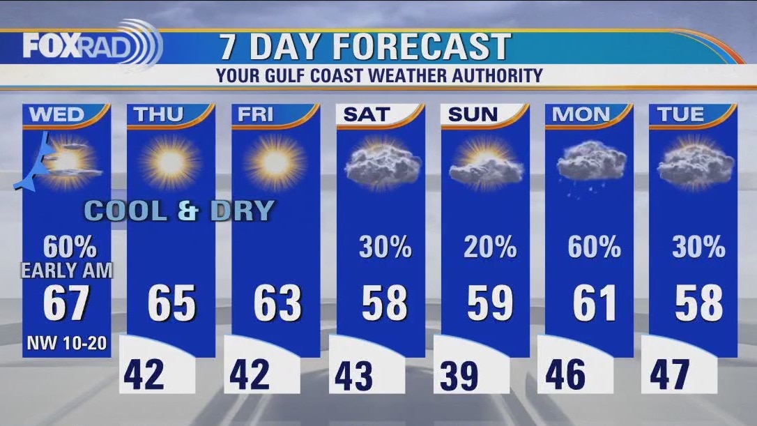
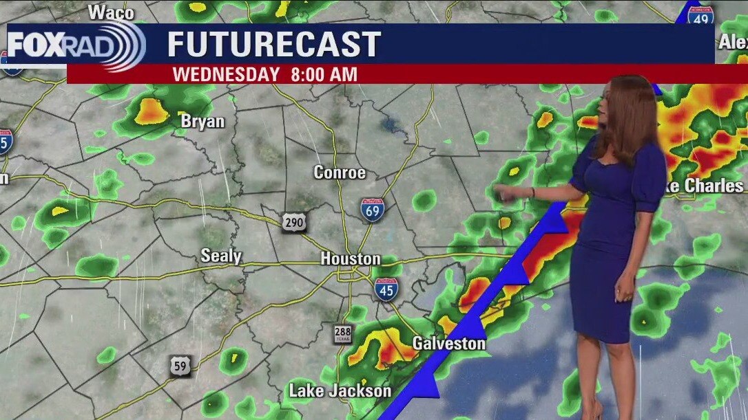
After Wednesday morning rain, cold front brings clear, dry, cooler weather
After early morning rain, a cold front will bring clear, very dry and cooler weather. Look for afternoon sun with breezy northwest winds today. Lows over the next several nights will drop to the upper 30s and low 40s with highs in the mid 60s. The pattern through Christmas still looks cold.
After early morning rain, a cold front will bring clear, very dry and cooler weather. Look for afternoon sun with breezy northwest winds today. Lows over the next several nights will drop to the upper 30s and low 40s with highs in the mid 60s. The pattern through Christmas still looks cold.
Wednesday morning weather forecast
A cold front will usher in much cooler and breezy conditions for the rest of the week. We set another record high at Houston Hobby Airport Tuesday reaching 82 degrees. But the heatwave is coming to an end. Look for more rain possible over the weekend with cooler temperatures sticking around.
A cold front will usher in much cooler and breezy conditions for the rest of the week. We set another record high at Houston Hobby Airport Tuesday reaching 82 degrees. But the heatwave is coming to an end. Look for more rain possible over the weekend with cooler temperatures sticking around.
Tuesday evening weather forecast with Meteorologist Remeisha Shade
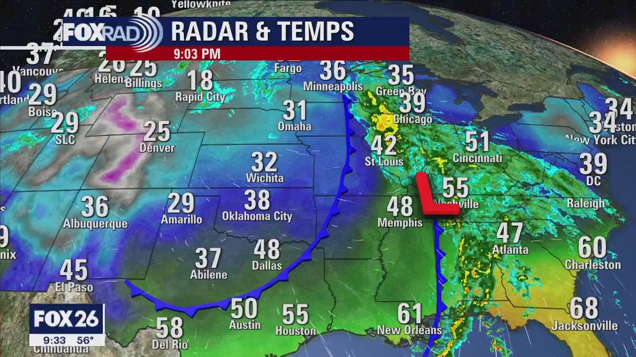
Tornado Watch remains in effect until 10 PM for Polk county. There's still a small risk for a brief tornado and a few damaging wind gusts through early tonight as a strong cold front moves in. The main event for the late night hours will be the potential for heavy rain that could lead to a few flooding issues. Cold front ushers in much cooler and breezy conditions for the rest of the week. We set another record high at Houston Hobby Airport today reaching 82 degrees. But the heatwave is coming to an end. Look for more rain possible over the weekend with cooler temperatures sticking around.
Tornado Watch remains in effect until 10 PM for Polk county. There's still a small risk for a brief tornado and a few damaging wind gusts through early tonight as a strong cold front moves in. The main event for the late night hours will be the potential for heavy rain that could lead to a few flooding issues. Cold front ushers in much cooler and breezy conditions for the rest of the week. We set another record high at Houston Hobby Airport today reaching 82 degrees. But the heatwave is coming to an end. Look for more rain possible over the weekend with cooler temperatures sticking around.
Tuesday afternoon weather forecast with Meteorologist John Dawson
Big changes are on the way and we expect several cold fronts to keep the forecast interesting here for the rest of 2022. Today's main concern is severe weather which could begin by early afternoon and last off and on through overnight tonight. The highest risk will be north of Houston, then northeast by this evening. After the front passes Wednesday morning, we'll enter a chillier pattern lows in the 40s and highs in the 50s and 60s.
Big changes are on the way and we expect several cold fronts to keep the forecast interesting here for the rest of 2022. Today's main concern is severe weather which could begin by early afternoon and last off and on through overnight tonight. The highest risk will be north of Houston, then northeast by this evening. After the front passes Wednesday morning, we'll enter a chillier pattern lows in the 40s and highs in the 50s and 60s.