

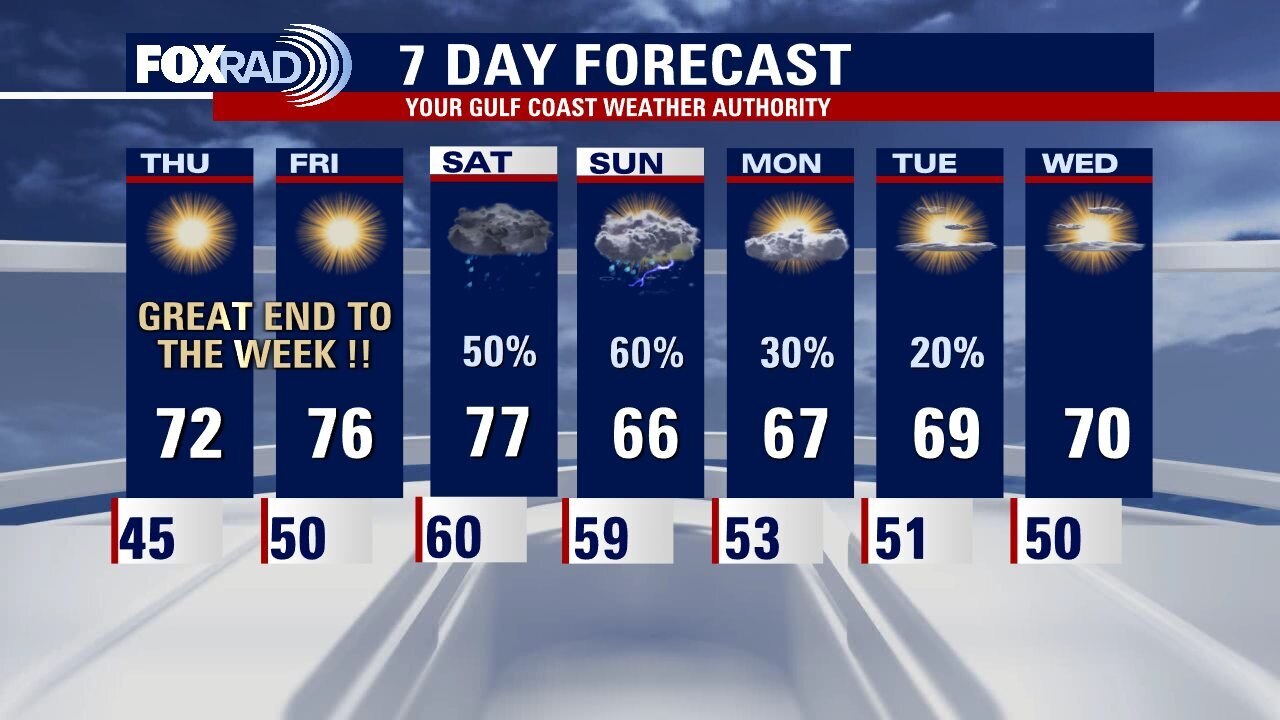
Houston weather: Cool start Friday, then breezy & warm this afternoon
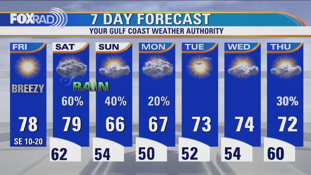
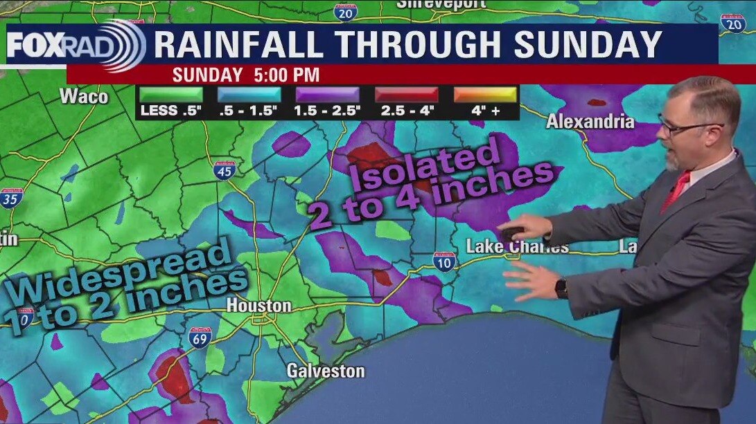
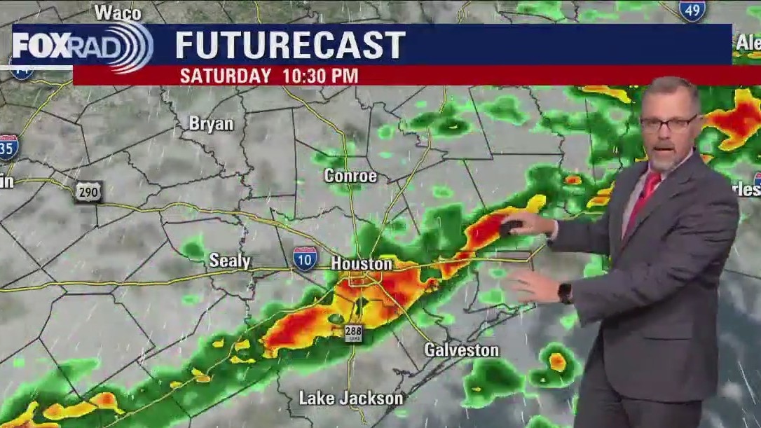
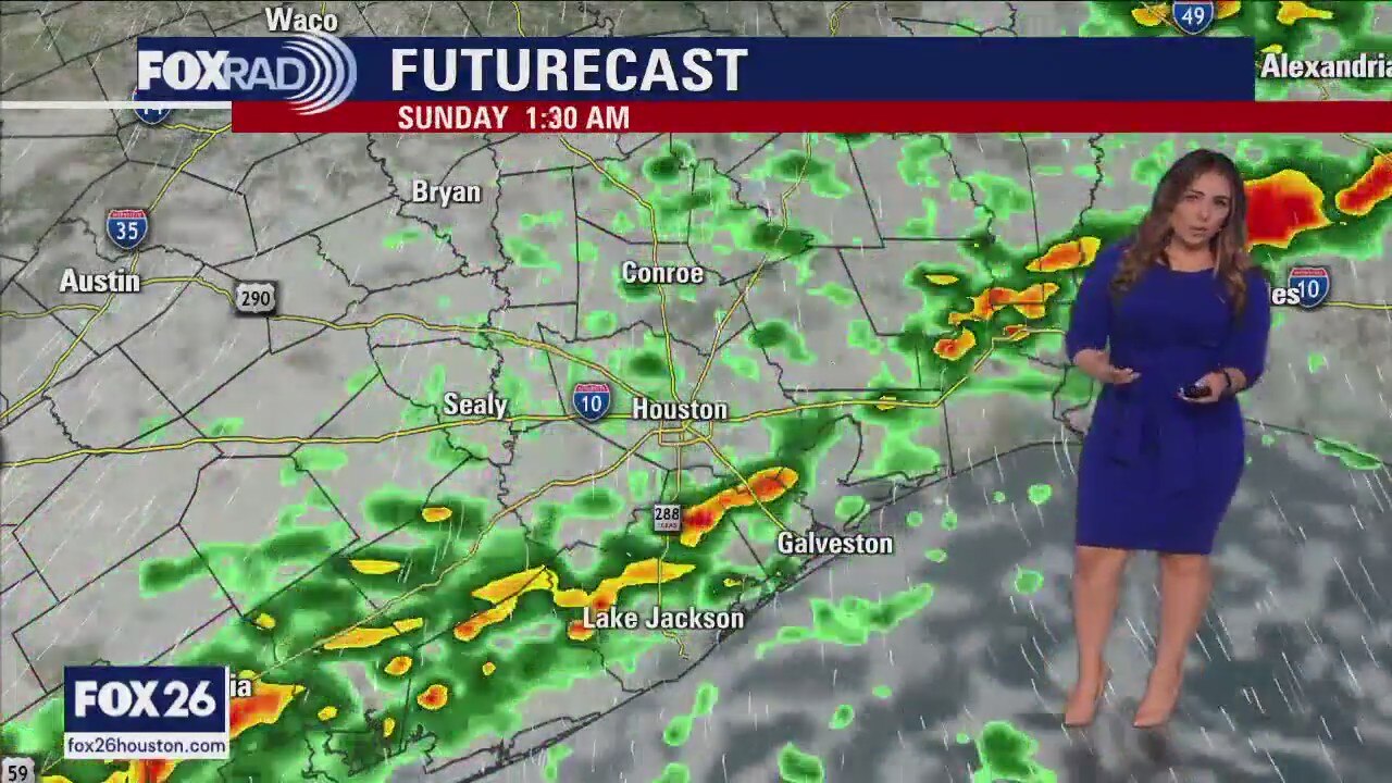
A glorious end to the work week, with abundant sunshine and increasing humidity that will have us flirting with record highs today and tomorrow. Scattered rain and storms are likely Saturday afternoon through Sunday morning as a front works its way through the area. A few other disturbances keep rain chances low, but in the forecast through Monday. Midweek looks warm and sunny, and another front may pass through Wednesday night into Thursday morning.
A glorious end to the work week, with abundant sunshine and increasing humidity that will have us flirting with record highs today and tomorrow. Scattered rain and storms are likely Saturday afternoon through Sunday morning as a front works its way through the area. A few other disturbances keep rain chances low, but in the forecast through Monday. Midweek looks warm and sunny, and another front may pass through Wednesday night into Thursday morning.
Friday morning Houston-area weather forecast
Friday should be another beauty across Southeast Texas. The South wind will increase in the afternoon helping to add humidity around Houston. Showers and some thunderstorms will form as a front reaches the coast late on Saturday. Rain chances should hang around most of the day Sunday. A quiet pattern returns for the start of the work week.
Friday should be another beauty across Southeast Texas. The South wind will increase in the afternoon helping to add humidity around Houston. Showers and some thunderstorms will form as a front reaches the coast late on Saturday. Rain chances should hang around most of the day Sunday. A quiet pattern returns for the start of the work week.
Clear skies Thursday evening in the 70s
Friday should be another beauty across Southeast Texas. The South wind will increase in the afternoon helping to add humidity around Houston. Showers and some thunderstorms will form as a front reaches the coast late on Saturday. Rain chances should hang around most of the day Sunday. A quiet pattern returns for the start of the work week.
Friday should be another beauty across Southeast Texas. The South wind will increase in the afternoon helping to add humidity around Houston. Showers and some thunderstorms will form as a front reaches the coast late on Saturday. Rain chances should hang around most of the day Sunday. A quiet pattern returns for the start of the work week.
Warm, pleasant Thursday afternoon in the 70s
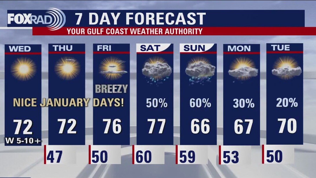
Two more days of bliss, before cloud cover increases and rain chances go up. Won't be a total washout all weekend, but scattered showers and storms mainly in the latter part of Saturday into the early part of Sunday may interrupt your outdoor plans. We look to stay somewhat unsettled through early next week, with no major decrease in temperatures given that this front is coming from the Pacific rather than the north. Enjoy the mild January air!
Two more days of bliss, before cloud cover increases and rain chances go up. Won't be a total washout all weekend, but scattered showers and storms mainly in the latter part of Saturday into the early part of Sunday may interrupt your outdoor plans. We look to stay somewhat unsettled through early next week, with no major decrease in temperatures given that this front is coming from the Pacific rather than the north. Enjoy the mild January air!

Houston weather: Clear and chilly Thursday morning, then sunny, dry and mild
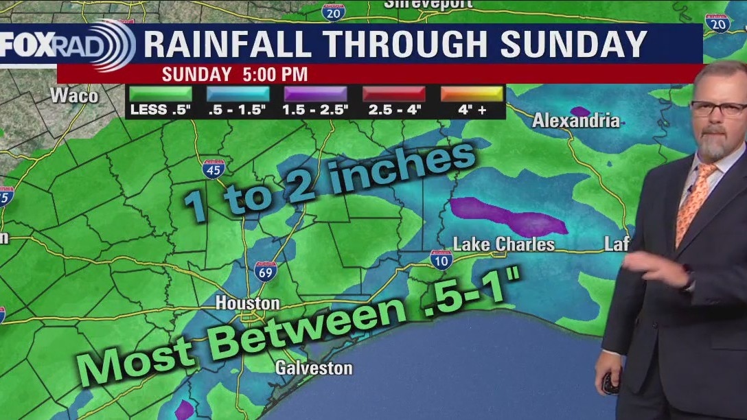
Enjoy another great day today with sunshine, low humidity and pleasant January highs near 70. A south breeze kicks in on Friday which will gradually bringing more humidity along with warmer temperatures. This weekend, a small ripple of the big Pacific storm system will help to bring a weak front and a high chance for showers and storms, especially late Saturday and early Sunday.
Enjoy another great day today with sunshine, low humidity and pleasant January highs near 70. A south breeze kicks in on Friday which will gradually bringing more humidity along with warmer temperatures. This weekend, a small ripple of the big Pacific storm system will help to bring a weak front and a high chance for showers and storms, especially late Saturday and early Sunday.
Thursday morning Houston-area weather forecast
The great weather continues for Southeast Texas to finish out the work week. Expect a breezy Friday as the next Pacific storm systems moves across the country, eventually increasing rain chances for Houston over the weekend. Don't look for a complete washout of a weekend but there will be some showers and isolated storms to dodge.
The great weather continues for Southeast Texas to finish out the work week. Expect a breezy Friday as the next Pacific storm systems moves across the country, eventually increasing rain chances for Houston over the weekend. Don't look for a complete washout of a weekend but there will be some showers and isolated storms to dodge.
Wednesday evening weather forecast with Meteorologist John Dawson
The great weather continues for Southeast Texas to finish out the work week. Expect a breezy Friday as the next Pacific storm system moves across the country, eventually increasing rain chances for Houston over the weekend. Don't look for a complete washout of a weekend but there will be some showers and isolated storms to dodge.
The great weather continues for Southeast Texas to finish out the work week. Expect a breezy Friday as the next Pacific storm system moves across the country, eventually increasing rain chances for Houston over the weekend. Don't look for a complete washout of a weekend but there will be some showers and isolated storms to dodge.
Dry, quiet Wednesday afternoon in the 70s
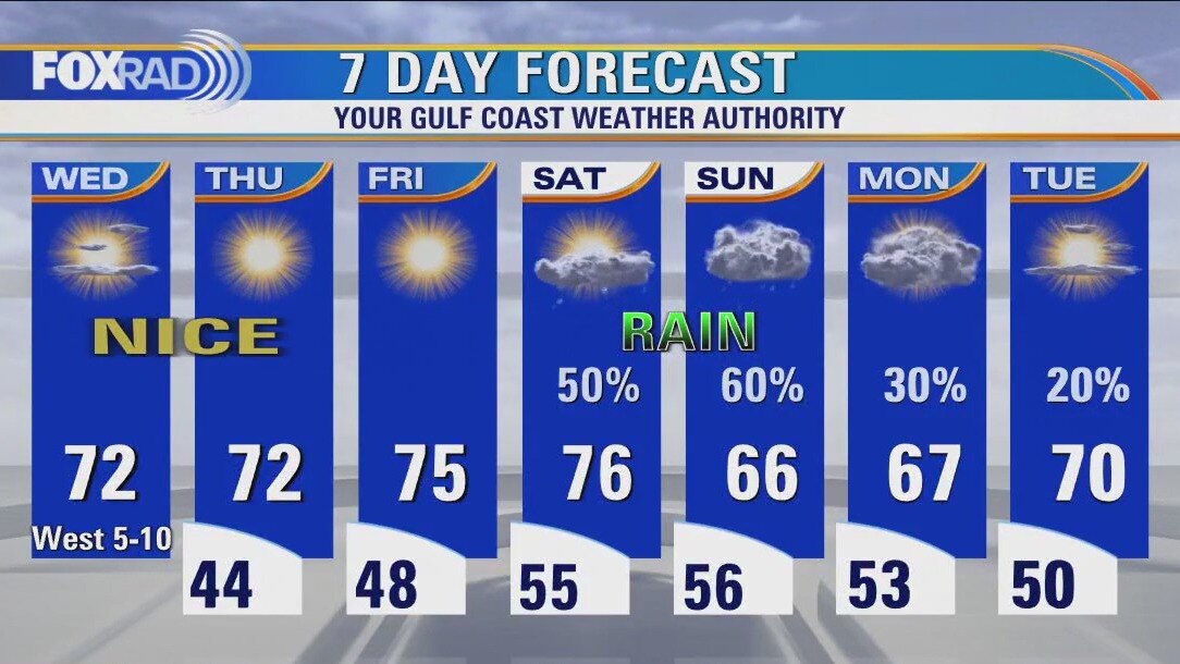
We've got a stretch of very pleasant weather to round out the work week, followed by unfortunately a fairly soggy weekend. Not looking like a washout, but a Pacific front will bring storms on and off through early next week. Temperature wise we look to remain seasonably normal, if not slightly above.
We've got a stretch of very pleasant weather to round out the work week, followed by unfortunately a fairly soggy weekend. Not looking like a washout, but a Pacific front will bring storms on and off through early next week. Temperature wise we look to remain seasonably normal, if not slightly above.
Chilly Wednesday morning, then mostly sunny and dry with highs in low 70s
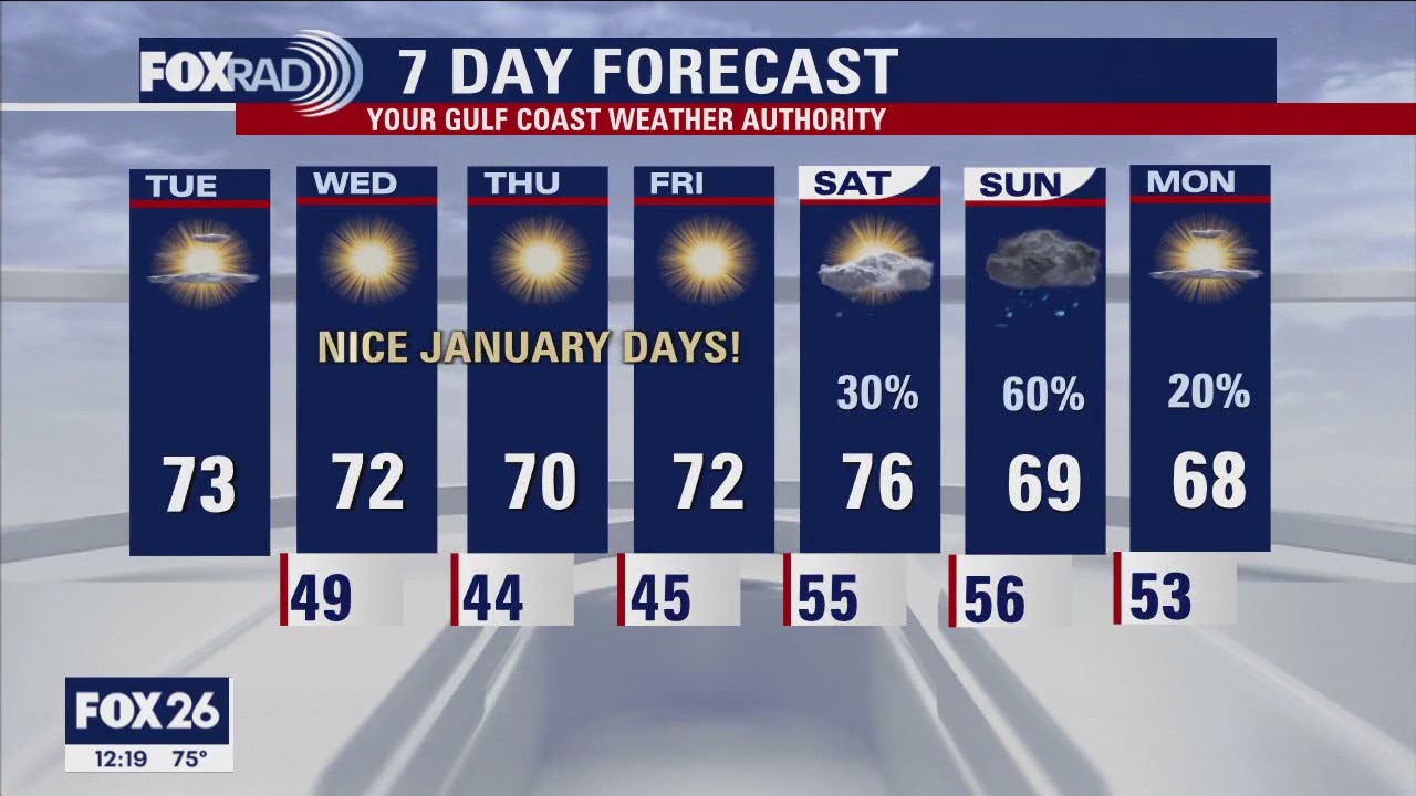
We're going to enjoy three days of beautiful, quiet weather with sunny, dry days and clear, cool nights. A large storm system slamming California will send an impulse toward Texas this weekend, so showers and a few storms are likely from late Saturday through Sunday. Overall, our temperatures should trend warmer than normal for January.
We're going to enjoy three days of beautiful, quiet weather with sunny, dry days and clear, cool nights. A large storm system slamming California will send an impulse toward Texas this weekend, so showers and a few storms are likely from late Saturday through Sunday. Overall, our temperatures should trend warmer than normal for January.
Wednesday morning weather forecast
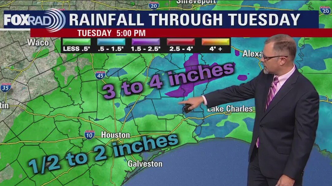
Cold front that brought rain and a few storms yesterday and this morning has pushed out of our area to the east taking the threat of any rain or severe weather with it. Skies are clearing and high pressure is building in. Winds tonight will be out of the NW around 5-10 mph and that will usher in some cooler air overnight with many parts of SE Texas dipping into the 40s. Look for a few beautiful, bright and pleasant days Wednesday through Friday with lots of sunshine and highs near 70. More clouds and rain will return for the weekend with the best chance for rain on Sunday.
Cold front that brought rain and a few storms yesterday and this morning has pushed out of our area to the east taking the threat of any rain or severe weather with it. Skies are clearing and high pressure is building in. Winds tonight will be out of the NW around 5-10 mph and that will usher in some cooler air overnight with many parts of SE Texas dipping into the 40s. Look for a few beautiful, bright and pleasant days Wednesday through Friday with lots of sunshine and highs near 70. More clouds and rain will return for the weekend with the best chance for rain on Sunday.

Tuesday evening weather forecast with Meteorologist Remeisha Shade
The cold front that brought rain and a few storms yesterday and this morning has pushed out of our area to the east taking the threat of any rain or severe weather with it. Skies are clearing and high pressure is building in. Winds tonight will be out of the NW around 5-10 mph and that will usher in some cooler air overnight with many parts of SE Texas dipping into the 40s. Look for a few beautiful, bright and pleasant days Wednesday through Friday with lots of sunshine and highs near 70. More clouds and rain will return for the weekend with the best chance for rain on Sunday.
The cold front that brought rain and a few storms yesterday and this morning has pushed out of our area to the east taking the threat of any rain or severe weather with it. Skies are clearing and high pressure is building in. Winds tonight will be out of the NW around 5-10 mph and that will usher in some cooler air overnight with many parts of SE Texas dipping into the 40s. Look for a few beautiful, bright and pleasant days Wednesday through Friday with lots of sunshine and highs near 70. More clouds and rain will return for the weekend with the best chance for rain on Sunday.
Tuesday afternoon weather forecast with Meteorologist John Dawson
We've got pleasant, cooler, and much drier weather after an early morning cold front. This week will bring clear, cool nights and seasonably cool days with more sunshine on the way. A slow-moving front this weekend should bring our next round of rain.
We've got pleasant, cooler, and much drier weather after an early morning cold front. This week will bring clear, cool nights and seasonably cool days with more sunshine on the way. A slow-moving front this weekend should bring our next round of rain.

Early Tuesday morning line of rain, then gradual clearing
Following an early morning cold front, our weather will turn pleasant, cooler and much drier. This week will bring clear, cool nights and seasonably cool days with more sunshine on the way. A slow-moving front this weekend should bring our next round of rain.
Following an early morning cold front, our weather will turn pleasant, cooler and much drier. This week will bring clear, cool nights and seasonably cool days with more sunshine on the way. A slow-moving front this weekend should bring our next round of rain.
Tuesday morning weather forecast
A cold front moves through Southeast Texas early on Tuesday morning bringing a line of showers and storms across the Houston area before sunrise. Seasonal temperatures settle in place behind the front and remain for the rest of the week. Rain returns to the forecast for this weekend.
A cold front moves through Southeast Texas early on Tuesday morning bringing a line of showers and storms across the Houston area before sunrise. Seasonal temperatures settle in place behind the front and remain for the rest of the week. Rain returns to the forecast for this weekend.
Monday evening weather forecast
A cold front moves through Southeast Texas early on Tuesday morning bringing a line of showers and storms across the Houston area before sunrise. Seasonal temperatures settle in place behind the front and remain for the rest of the week. Rain returns to the forecast for this weekend.
A cold front moves through Southeast Texas early on Tuesday morning bringing a line of showers and storms across the Houston area before sunrise. Seasonal temperatures settle in place behind the front and remain for the rest of the week. Rain returns to the forecast for this weekend.
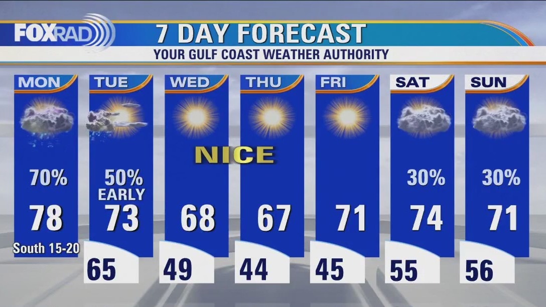
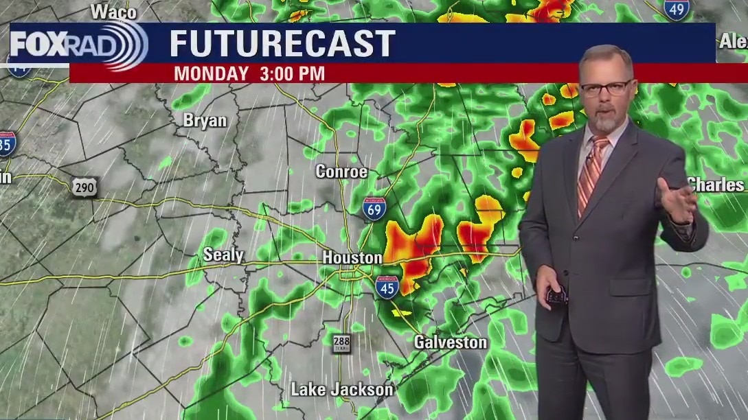
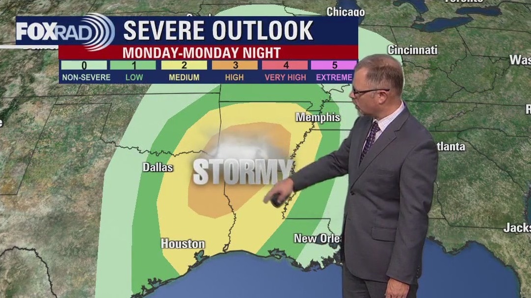
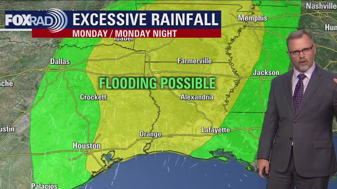
Chance for scattered strong storms on Monday
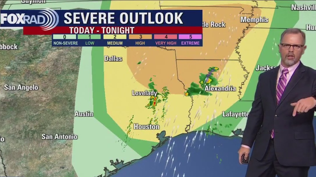
We will be closely watching FoxRad radar with a chance for scattered strong storms today, tonight and very early Tuesday. It looks like the storms will be fast-moving and with isolated coverage, but could be intense with high winds and even isolated tornadoes not impossible. Otherwise, the rest of the week looks great from Tuesday afternoon all the way through Friday.
We will be closely watching FoxRad radar with a chance for scattered strong storms today, tonight and very early Tuesday. It looks like the storms will be fast-moving and with isolated coverage, but could be intense with high winds and even isolated tornadoes not impossible. Otherwise, the rest of the week looks great from Tuesday afternoon all the way through Friday.
Partly cloudy, warm Sunday afternoon in the 70s
Monday is still on track to be stormy around southeast Texas in the afternoon. Look for showers to start in the morning but heavier downpours and stronger storms are expected to form around Houston in the evening as a front approaches. Starting Tuesday afternoon, plan to enjoy some seasonal temperatures and dry conditions through the end of the work week.
Monday is still on track to be stormy around southeast Texas in the afternoon. Look for showers to start in the morning but heavier downpours and stronger storms are expected to form around Houston in the evening as a front approaches. Starting Tuesday afternoon, plan to enjoy some seasonal temperatures and dry conditions through the end of the work week.

Sunday morning weather forecast with Meteorologist Lena Maria Arango
Fog and smoke should clear by midday, leading to a partly to mostly cloudy and humid first day of the year with a few light passing showers. Monday is really our only "bump in the road" this week, with strong to severe storm potential in the afternoon and evening. Gusty winds and locally heavy rainfall are our main concerns, the remainder of the week looks blissful past that!
Fog and smoke should clear by midday, leading to a partly to mostly cloudy and humid first day of the year with a few light passing showers. Monday is really our only "bump in the road" this week, with strong to severe storm potential in the afternoon and evening. Gusty winds and locally heavy rainfall are our main concerns, the remainder of the week looks blissful past that!
New Years Day morning forecast
Happy New Year! Great looking day to start 2023 in Houston as long as you don't mind warm afternoon temperatures. Monday brings stormy weather back to southeast Texas as another storm system marches across the country. Look for showers/storms during most of the day with stronger storms in the late afternoon. Clear skies and seasonal temperatures are expected for the end of the week.
Happy New Year! Great looking day to start 2023 in Houston as long as you don't mind warm afternoon temperatures. Monday brings stormy weather back to southeast Texas as another storm system marches across the country. Look for showers/storms during most of the day with stronger storms in the late afternoon. Clear skies and seasonal temperatures are expected for the end of the week.
New Year's Eve Evening Forecast
Happy New Year! Great looking day to start 2023 in Houston as long as you don't mind warm afternoon temperatures. Monday brings stormy weather back to southeast Texas as another storm system marches across the country. Look for showers/storms during most of the day with stronger storms in the late afternoon. Clear skies and seasonal temperatures are expected for the end of the week.
Happy New Year! Great looking day to start 2023 in Houston as long as you don't mind warm afternoon temperatures. Monday brings stormy weather back to southeast Texas as another storm system marches across the country. Look for showers/storms during most of the day with stronger storms in the late afternoon. Clear skies and seasonal temperatures are expected for the end of the week.