


Wednesday afternoon weather forecast with Meteorologist Lena Maria
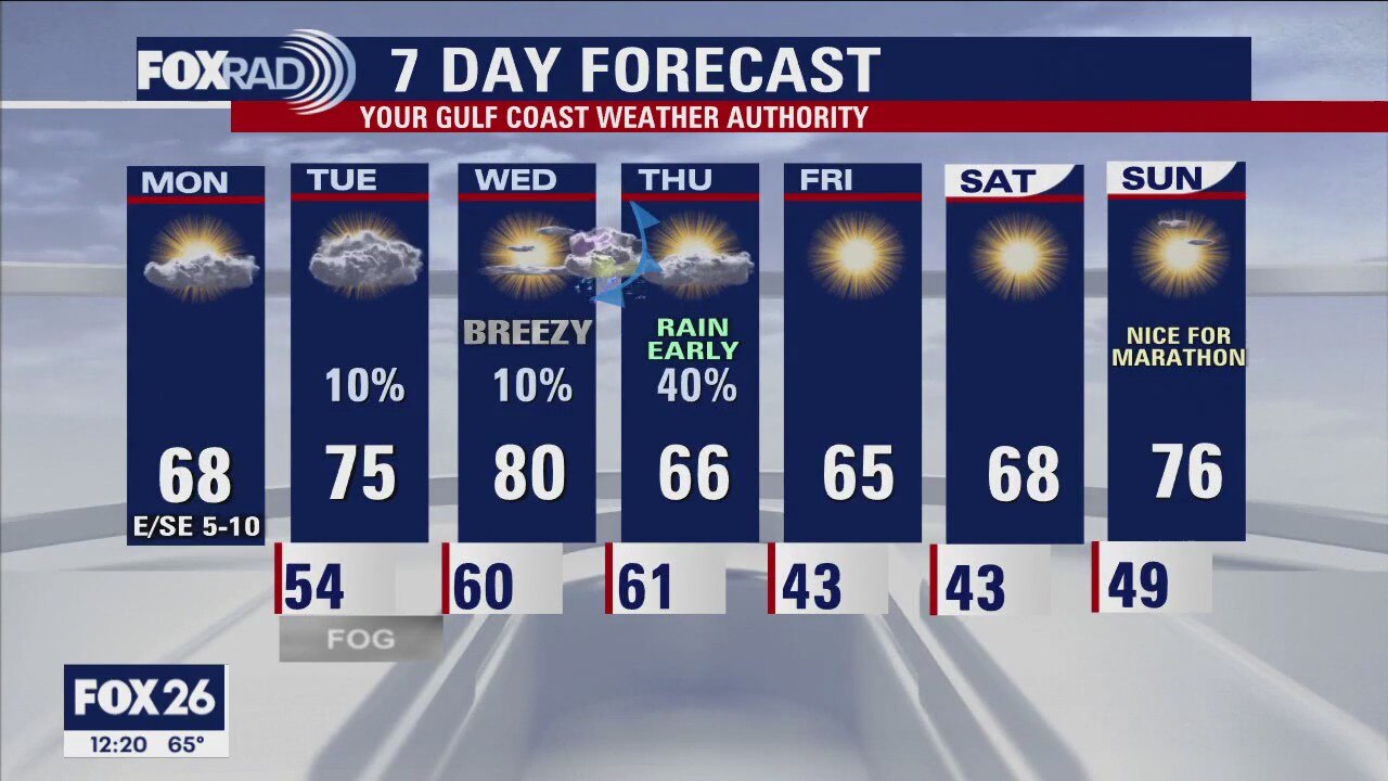
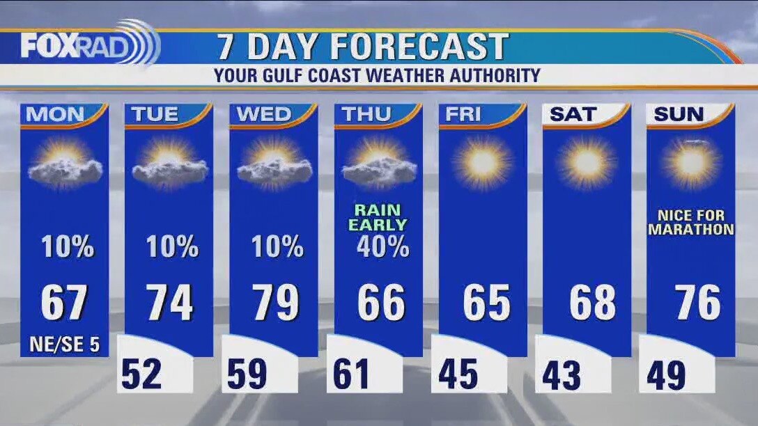
Wednesday will be warm and breezy, then a cool front will bring a thin line of showers/storms through overnight. As high pressure builds in behind that, we'll enjoy several quiet sunny days with near-normal temperatures. Warmth quickly returns though, toward the tail-end of the weekend. Marathoners can expect great starting conditions, followed by a warm and breezy finish. Showers look to return on Monday for Martin Luther King Day, with another shot at record breaking warmth on Tuesday.
Wednesday will be warm and breezy, then a cool front will bring a thin line of showers/storms through overnight. As high pressure builds in behind that, we'll enjoy several quiet sunny days with near-normal temperatures. Warmth quickly returns though, toward the tail-end of the weekend. Marathoners can expect great starting conditions, followed by a warm and breezy finish. Showers look to return on Monday for Martin Luther King Day, with another shot at record breaking warmth on Tuesday.
Houston weather: Breezy and warm Wednesday ahead of cold front
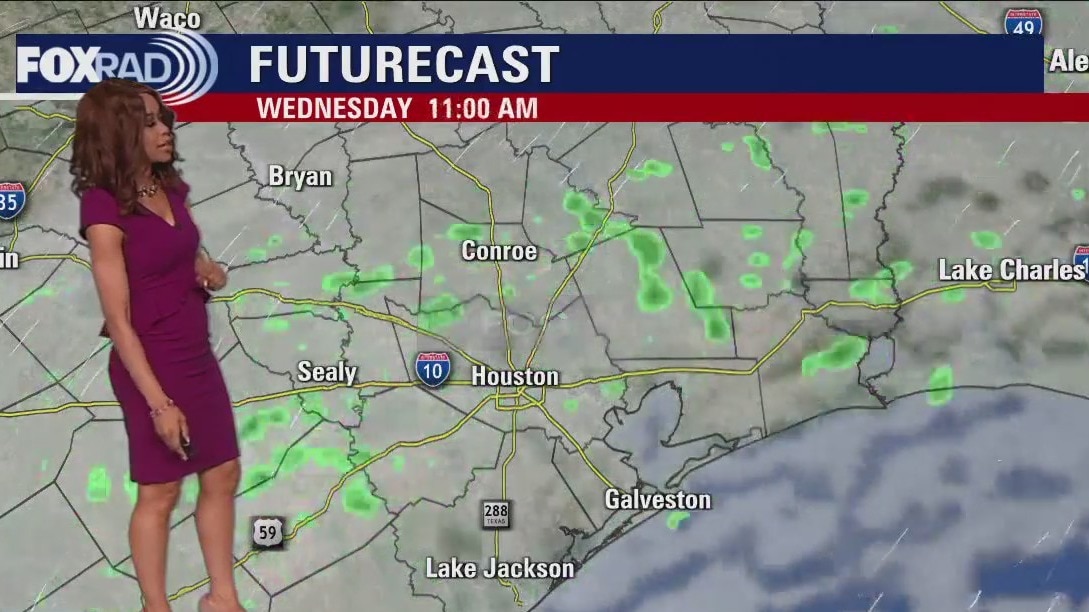
Today is going to be a breezy and warm one with the potential for record high temperatures. Today's records are 81� for Houston and 75� for Galveston and we'll get close. Tonight, a cold front moves in and the best rain chances look to be between around 2 a.m. and 6 a.m. early Thursday. Following that front, look for breezy and cooler weather Thursday with highs in the 60s. We'll have a couple of chilly mornings with lows near 40 on Friday and Saturday morning.
Today is going to be a breezy and warm one with the potential for record high temperatures. Today's records are 81� for Houston and 75� for Galveston and we'll get close. Tonight, a cold front moves in and the best rain chances look to be between around 2 a.m. and 6 a.m. early Thursday. Following that front, look for breezy and cooler weather Thursday with highs in the 60s. We'll have a couple of chilly mornings with lows near 40 on Friday and Saturday morning.
Wednesday morning Houston-area weather forecast
It's been another beautiful January day after a foggy start. Look for more low clouds and fog to develop late tonight, especially near the coast. Fog is not expected to be as thick or widespread as this morning though. Near record high temperatures near 80 are on the way for Wednesday with breezy weather. Cold front will push through early Thursday morning bringing widely scattered showers and possibly a few storms. The good news is that the severe storm threat should remain out of our area.
It's been another beautiful January day after a foggy start. Look for more low clouds and fog to develop late tonight, especially near the coast. Fog is not expected to be as thick or widespread as this morning though. Near record high temperatures near 80 are on the way for Wednesday with breezy weather. Cold front will push through early Thursday morning bringing widely scattered showers and possibly a few storms. The good news is that the severe storm threat should remain out of our area.
Tuesday evening weather forecast with Meteorologist Remeisha Shade
It's been another beautiful January day after a foggy start. Look for more low clouds and fog to develop late tonight, especially near the coast. Fog is not expected to be as thick or widespread as this morning though. Near record-high temperatures near 80 are on the way for Wednesday with breezy weather. A cold front will push through early Thursday morning bringing widely scattered showers and possibly a few storms. The good news is that the severe storm threat should remain out of our area.
It's been another beautiful January day after a foggy start. Look for more low clouds and fog to develop late tonight, especially near the coast. Fog is not expected to be as thick or widespread as this morning though. Near record-high temperatures near 80 are on the way for Wednesday with breezy weather. A cold front will push through early Thursday morning bringing widely scattered showers and possibly a few storms. The good news is that the severe storm threat should remain out of our area.

Tuesday afternoon weather forecast with Chief Meteorologist Mike Iscovitz
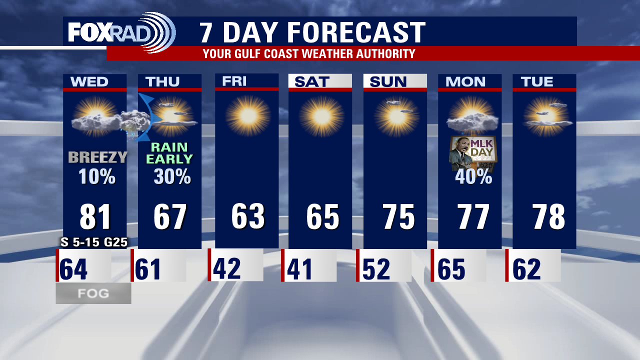
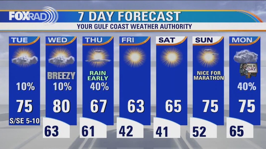
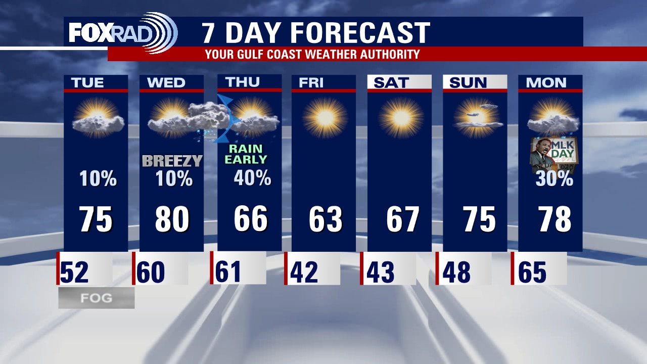
After a blanket of the morning fog, today will be a warmer-than-normal one with highs running about 12 degrees above average. Tomorrow looks breezy and even warmer with a record high possible. A cold front will move in early Thursday and could bring a brief round of storms followed by a few chilly mornings with lows near 40. The weather looks fine for the marathon this weekend, but showers could return for Martin Luther King Day on Monday.
After a blanket of the morning fog, today will be a warmer-than-normal one with highs running about 12 degrees above average. Tomorrow looks breezy and even warmer with a record high possible. A cold front will move in early Thursday and could bring a brief round of storms followed by a few chilly mornings with lows near 40. The weather looks fine for the marathon this weekend, but showers could return for Martin Luther King Day on Monday.
Houston weather: Misty and foggy Tuesday morning, then partly cloudy and warmer
After a blanket of morning fog, today will be a warmer than normal one with highs running about 12 degrees above average. Tomorrow looks breezy and even warmer with a record high possible. A cold front will move in early Thursday and could bring a brief round of storms followed by a few chilly mornings with lows near 40. Weather looks fine for the marathon this weekend, but showers could return for Martin Luther King Day on Monday.
After a blanket of morning fog, today will be a warmer than normal one with highs running about 12 degrees above average. Tomorrow looks breezy and even warmer with a record high possible. A cold front will move in early Thursday and could bring a brief round of storms followed by a few chilly mornings with lows near 40. Weather looks fine for the marathon this weekend, but showers could return for Martin Luther King Day on Monday.

Tuesday morning Houston-area weather forecast
After a soggy weekend, it's been a beautiful start to the work week although a tiny bit cooler. Look for light jacket weather to prevail tonight with lows in the 50s for most areas. Big time heat returns over the next few days with high temperatures near 80 Wednesday which will be flirting with records again. Our one decent shot for rain this week comes Wednesday night into early Thursday with our next cold front. A few strong storms may accompany the front with the best shot north of Houston up towards Huntsville. After that we dry out through the weekend with mild temperatures expected.
After a soggy weekend, it's been a beautiful start to the work week although a tiny bit cooler. Look for light jacket weather to prevail tonight with lows in the 50s for most areas. Big time heat returns over the next few days with high temperatures near 80 Wednesday which will be flirting with records again. Our one decent shot for rain this week comes Wednesday night into early Thursday with our next cold front. A few strong storms may accompany the front with the best shot north of Houston up towards Huntsville. After that we dry out through the weekend with mild temperatures expected.
Monday evening weather forecast with Meteorologist Remeisha Shade
After a soggy weekend, it's been a beautiful start to the work week although a tiny bit cooler. Look for light jacket weather to prevail tonight with lows in the 50s for most areas. Big-time heat returns over the next few days with high temperatures near 80 Wednesday which will be flirting with records again. Our one decent shot for rain this week comes Wednesday night into early Thursday with our next cold front. A few strong storms may accompany the front with the best shot north of Houston up towards Huntsville. After that, we dry out through the weekend with mild temperatures expected.
After a soggy weekend, it's been a beautiful start to the work week although a tiny bit cooler. Look for light jacket weather to prevail tonight with lows in the 50s for most areas. Big-time heat returns over the next few days with high temperatures near 80 Wednesday which will be flirting with records again. Our one decent shot for rain this week comes Wednesday night into early Thursday with our next cold front. A few strong storms may accompany the front with the best shot north of Houston up towards Huntsville. After that, we dry out through the weekend with mild temperatures expected.
Monday afternoon weather forecast with Chief Meteorologist Mike Iscovitz
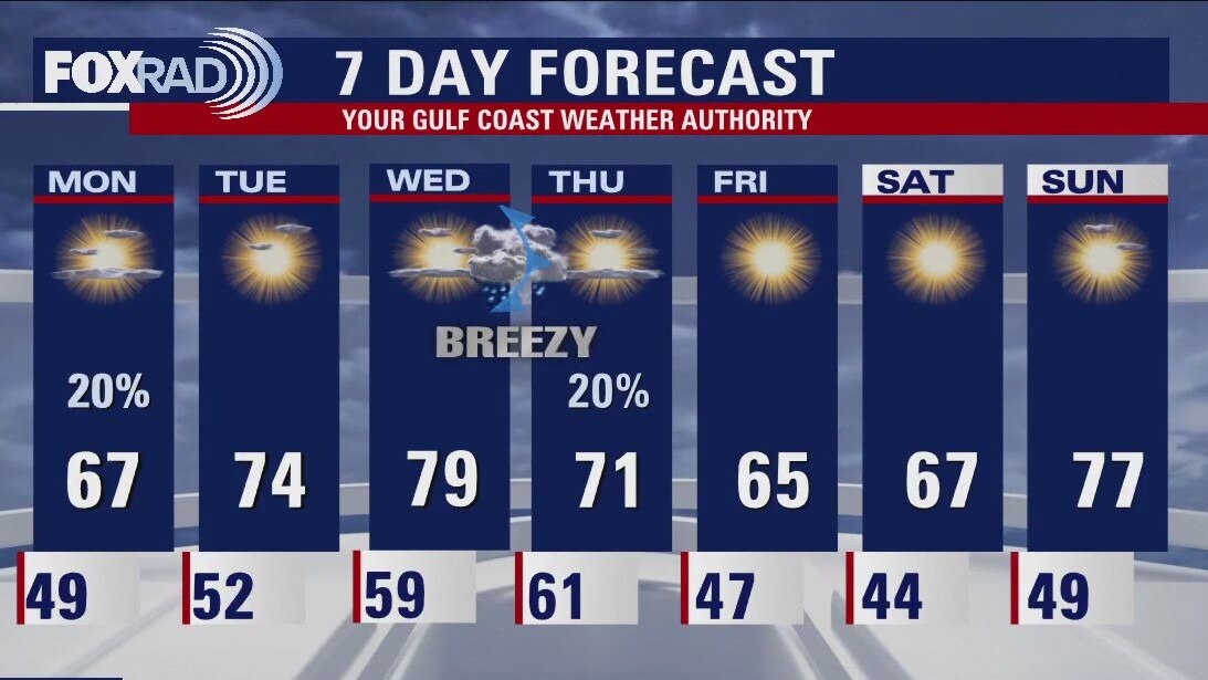
Following a weekend with heavy storms and up to 4" of rain Saturday night, this week looks tame with only one chance for storms Wednesday night or Thursday morning. Otherwise, expect pleasant temperatures ranging from lows in the 40s to highs in the 60s and 70s this week. The weather for the Houston Marathon this weekend looks pretty good, especially with a cool morning.
Following a weekend with heavy storms and up to 4" of rain Saturday night, this week looks tame with only one chance for storms Wednesday night or Thursday morning. Otherwise, expect pleasant temperatures ranging from lows in the 40s to highs in the 60s and 70s this week. The weather for the Houston Marathon this weekend looks pretty good, especially with a cool morning.
Houston weather: Chilly Monday morning, then cool with a few light showers possible
Following a weekend with heavy storms and up to 4" of rain Saturday night, this week looks tame with only one chance for storms Wednesday night or Thursday morning. Otherwise, expect pleasant temperatures ranging from lows in the 40s to highs in the 60s and 70s this week. Weather for the Houston Marathon this weekend looks pretty good, especially with a cool morning.
Following a weekend with heavy storms and up to 4" of rain Saturday night, this week looks tame with only one chance for storms Wednesday night or Thursday morning. Otherwise, expect pleasant temperatures ranging from lows in the 40s to highs in the 60s and 70s this week. Weather for the Houston Marathon this weekend looks pretty good, especially with a cool morning.
Sunday evening/Monday morning weather forecast
Most of the week ahead will be mild and quiet for Houston. Southeast Texas will have a couple of chances for some rain starting on Monday. Look for another round of showers and storms when a front arrives Wednesday night into early Thursday morning. The parade of Pacific Fronts won't bring any major cold blasts but they do keep the temperatures from creeping up into the 80s.
Most of the week ahead will be mild and quiet for Houston. Southeast Texas will have a couple of chances for some rain starting on Monday. Look for another round of showers and storms when a front arrives Wednesday night into early Thursday morning. The parade of Pacific Fronts won't bring any major cold blasts but they do keep the temperatures from creeping up into the 80s.
Warm, clear skies Sunday evening after severe storms
Most of the week ahead will be mild and quiet for Houston. Southeast Texas will have a couple of chances for some rain starting on Monday. Look for another round of showers and storms when a front arrives Wednesday night into early Thursday morning. The parade of Pacific Fronts won't bring any major cold blasts but they do keep the temperatures from creeping up into the 80s.
Most of the week ahead will be mild and quiet for Houston. Southeast Texas will have a couple of chances for some rain starting on Monday. Look for another round of showers and storms when a front arrives Wednesday night into early Thursday morning. The parade of Pacific Fronts won't bring any major cold blasts but they do keep the temperatures from creeping up into the 80s.

Sunday weather forecast with Meteorologist Lena Maria Arango
Clouds will decrease throughout the day Sunday, leading to a pleasant afternoon. Monday, an area of low pressure will bring a few showers but most of it looks to stay offshore. We'll gradually warm through midweek, with Wednesday being another day where records may fall. An overnight front midweek brings more showers and storms, followed by a much cooler and drier area leading into the weekend.
Clouds will decrease throughout the day Sunday, leading to a pleasant afternoon. Monday, an area of low pressure will bring a few showers but most of it looks to stay offshore. We'll gradually warm through midweek, with Wednesday being another day where records may fall. An overnight front midweek brings more showers and storms, followed by a much cooler and drier area leading into the weekend.

Saturday evening weather forecast with Meteorologist John Dawson
Showers and storms will continue across southeast Texas as a slow-moving cold front approaches the coast. Rain should start to break up around sunrise and skies start clearing around lunchtime. Clouds and a few showers will return to Houston on Monday. Look for mild temperatures to remain in the forecast for the next week.
Showers and storms will continue across southeast Texas as a slow-moving cold front approaches the coast. Rain should start to break up around sunrise and skies start clearing around lunchtime. Clouds and a few showers will return to Houston on Monday. Look for mild temperatures to remain in the forecast for the next week.

Saturday weather forecast with Meteorologist Lena Maria Arango
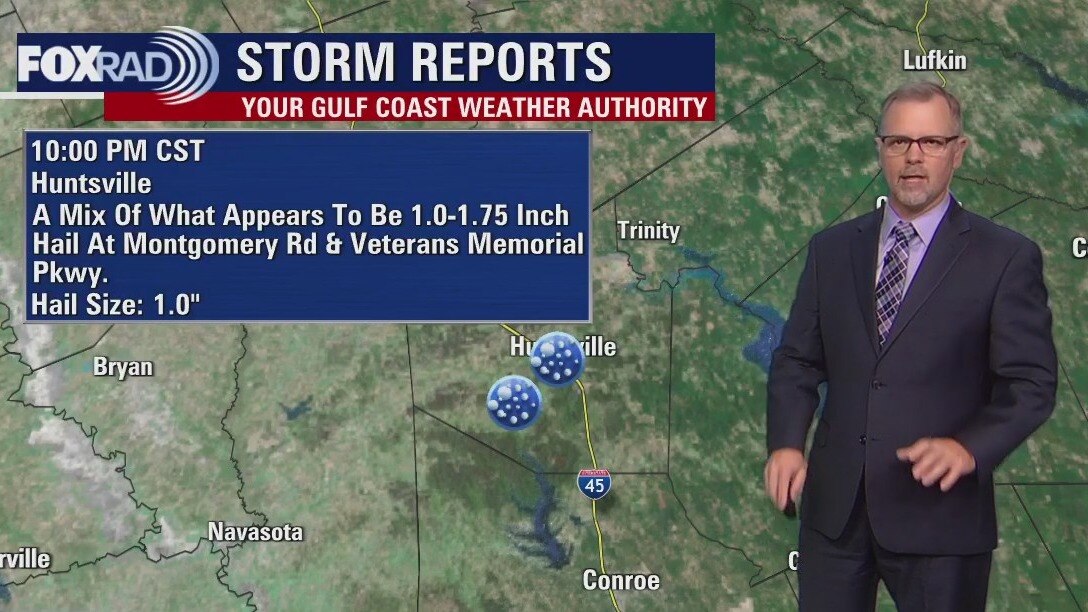
Saturday night features a low risk for strong to severe storms as a slow-moving front progresses across the area. The primary concerns are locally heavy rain, gusty winds, and maybe some hail. The front looks to clear the coastline by sunrise Sunday, leading to a much nicer end to the weekend. It is, however short-lived as a gulf disturbance brings the return of at least showers on Monday depending on how close to the coast it tracks. Sunshine and warmth will be sandwiched in between that, and another late week front that looks to bring a more promising cool-down.
Saturday night features a low risk for strong to severe storms as a slow-moving front progresses across the area. The primary concerns are locally heavy rain, gusty winds, and maybe some hail. The front looks to clear the coastline by sunrise Sunday, leading to a much nicer end to the weekend. It is, however short-lived as a gulf disturbance brings the return of at least showers on Monday depending on how close to the coast it tracks. Sunshine and warmth will be sandwiched in between that, and another late week front that looks to bring a more promising cool-down.
Saturday morning Houston-area forecast
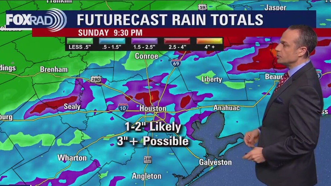
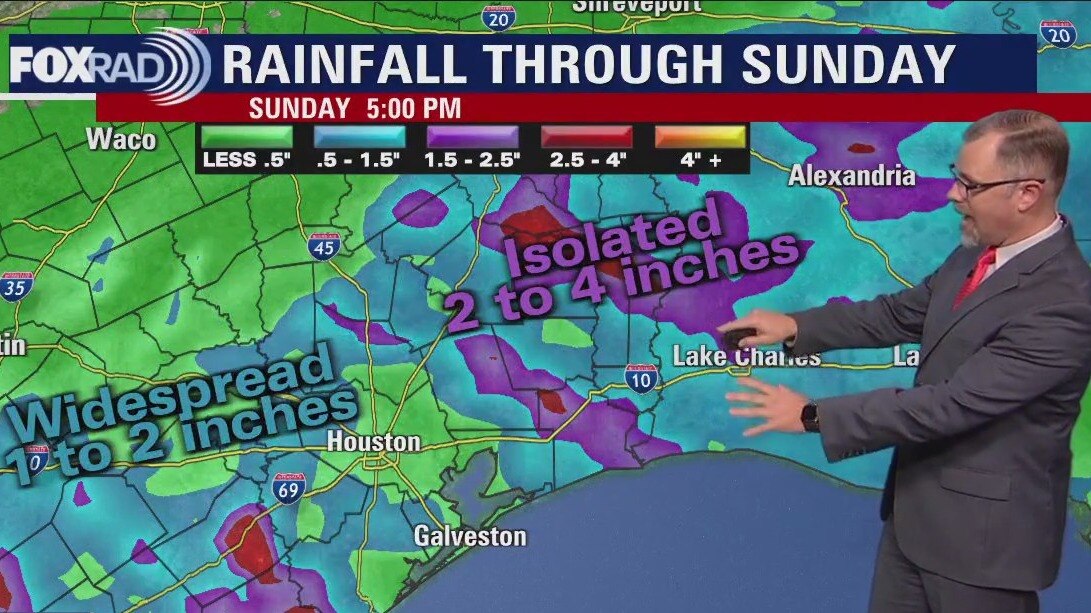
The weekend is here and just in time a front is going to bring a round of showers and storms. After some overnight and morning fog, the most likely timing for rain will be from Saturday afternoon through late morning Sunday. It looks like a scattering of showers and a few storms with potential for 1 to 2" of rain. A few spots could receive more, but overall, but a nice soaking. Next week, models are mixed on a quick round of showers on Monday, but overall the week looks fairly uneventful with cool nights and mild days.
The weekend is here and just in time a front is going to bring a round of showers and storms. After some overnight and morning fog, the most likely timing for rain will be from Saturday afternoon through late morning Sunday. It looks like a scattering of showers and a few storms with potential for 1 to 2" of rain. A few spots could receive more, but overall, but a nice soaking. Next week, models are mixed on a quick round of showers on Monday, but overall the week looks fairly uneventful with cool nights and mild days.
Clear skies Friday evening in the 70s with rain expected for the weekend
The weekend is here and just in time for a front is going to bring a round of showers and storms. After some overnight and morning fog, the most likely timing for rain will be from Saturday afternoon through late morning Sunday. It looks like a scattering of showers and a few storms with the potential for 1 to 2" of rain. A few spots could receive more, but overall, but a nice soaking. Next week, models are mixed on a quick round of showers on Monday, but overall the week looks fairly uneventful with cool nights and mild days.
The weekend is here and just in time for a front is going to bring a round of showers and storms. After some overnight and morning fog, the most likely timing for rain will be from Saturday afternoon through late morning Sunday. It looks like a scattering of showers and a few storms with the potential for 1 to 2" of rain. A few spots could receive more, but overall, but a nice soaking. Next week, models are mixed on a quick round of showers on Monday, but overall the week looks fairly uneventful with cool nights and mild days.
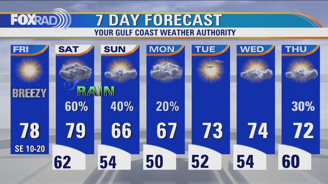
Warm, breezy Friday afternoon in the 70s
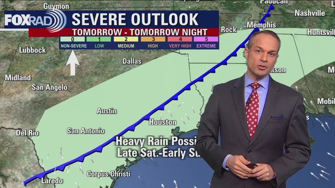
A glorious end to the work week, with abundant sunshine and increasing humidity that will have us flirting with record highs today and tomorrow. Scattered rain and storms are likely Saturday afternoon through Sunday morning as a front works its way through the area. A few other disturbances keep rain chances low, but in the forecast through Monday. Midweek looks warm and sunny, and another front may pass through Wednesday night into Thursday morning.
A glorious end to the work week, with abundant sunshine and increasing humidity that will have us flirting with record highs today and tomorrow. Scattered rain and storms are likely Saturday afternoon through Sunday morning as a front works its way through the area. A few other disturbances keep rain chances low, but in the forecast through Monday. Midweek looks warm and sunny, and another front may pass through Wednesday night into Thursday morning.
Houston weather: Cool start Friday, then breezy & warm this afternoon
A glorious end to the work week, with abundant sunshine and increasing humidity that will have us flirting with record highs today and tomorrow. Scattered rain and storms are likely Saturday afternoon through Sunday morning as a front works its way through the area. A few other disturbances keep rain chances low, but in the forecast through Monday. Midweek looks warm and sunny, and another front may pass through Wednesday night into Thursday morning.
A glorious end to the work week, with abundant sunshine and increasing humidity that will have us flirting with record highs today and tomorrow. Scattered rain and storms are likely Saturday afternoon through Sunday morning as a front works its way through the area. A few other disturbances keep rain chances low, but in the forecast through Monday. Midweek looks warm and sunny, and another front may pass through Wednesday night into Thursday morning.
Friday morning Houston-area weather forecast
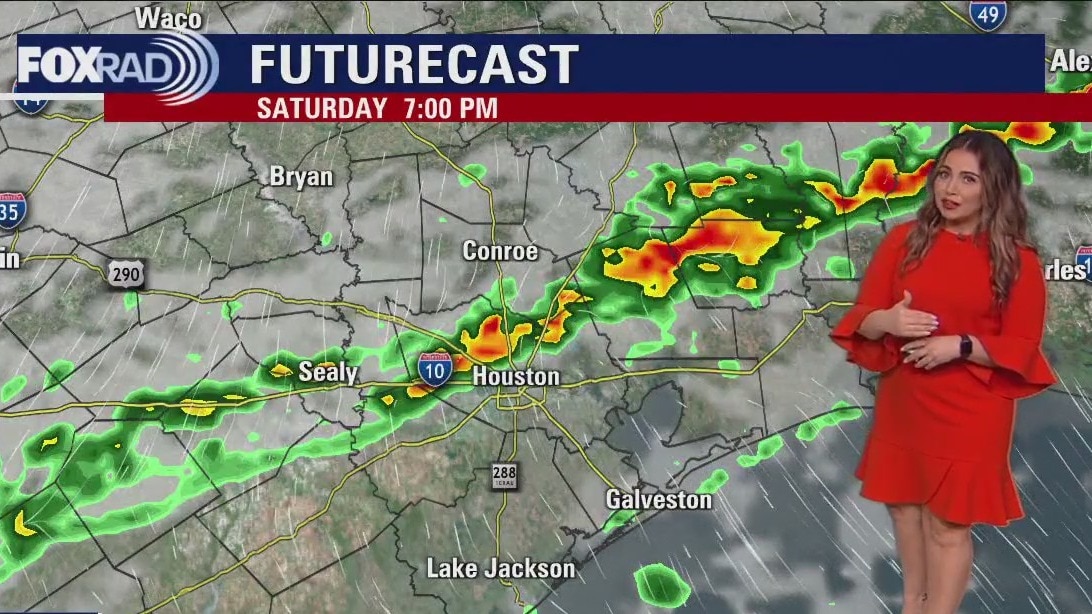
Friday should be another beauty across Southeast Texas. The South wind will increase in the afternoon helping to add humidity around Houston. Showers and some thunderstorms will form as a front reaches the coast late on Saturday. Rain chances should hang around most of the day Sunday. A quiet pattern returns for the start of the work week.
Friday should be another beauty across Southeast Texas. The South wind will increase in the afternoon helping to add humidity around Houston. Showers and some thunderstorms will form as a front reaches the coast late on Saturday. Rain chances should hang around most of the day Sunday. A quiet pattern returns for the start of the work week.