


Wednesday evening weather forecast with Meteorologist Remeisha Shade
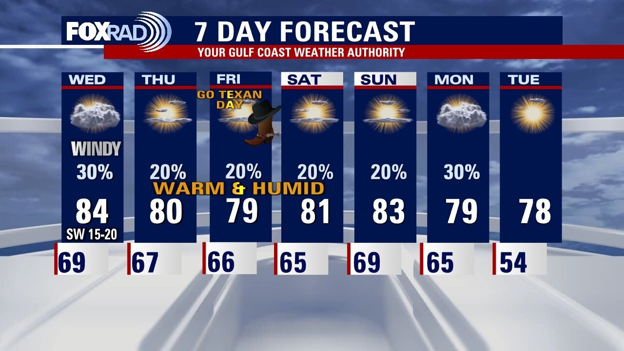
Weather leading up to the start of the Houston Livestock Show & Rodeo will stay on the warm side. World Championship BBQ Contest begins tomorrow and we should be near 80 by the afternoon with more clouds than sun and just a slim shot for rain. Look for some patchy fog the next few mornings with the thickest expected near the coast. We stay warm and mostly dry through the weekend with only a 10% chance for rain Friday for Go Texan Day and a 20% rain chance for the Rodeo Parade on Saturday. Cold front should bring slightly cooler and less humid air by Tuesday when the rodeo begins.
Weather leading up to the start of the Houston Livestock Show & Rodeo will stay on the warm side. World Championship BBQ Contest begins tomorrow and we should be near 80 by the afternoon with more clouds than sun and just a slim shot for rain. Look for some patchy fog the next few mornings with the thickest expected near the coast. We stay warm and mostly dry through the weekend with only a 10% chance for rain Friday for Go Texan Day and a 20% rain chance for the Rodeo Parade on Saturday. Cold front should bring slightly cooler and less humid air by Tuesday when the rodeo begins.

Windy, warm Wednesday afternoon in the 80s
A consistent, spring-like forecast will be with us for much of the next week. Plan for more clouds than sun, highs around 80, lows around 70 and slim rain chances. Patchy fog/mist is also likely in the mornings. Rain chances drop and sunshine looks to return just in time for the first official day of Rodeo!
A consistent, spring-like forecast will be with us for much of the next week. Plan for more clouds than sun, highs around 80, lows around 70 and slim rain chances. Patchy fog/mist is also likely in the mornings. Rain chances drop and sunshine looks to return just in time for the first official day of Rodeo!

Houston weather: Mostly cloudy, warm and windy Wednesday with isolated showers
Expect a windy, warm Wednesday with a slight chance for showers and highs in the mid 80s! The outlook for the rodeo cookoff, Go Texan Day, the parade and all the rodeo fun is looking spring-like with daily highs near 80 and lows near 70. Rain chances each day look light and only about 20%.
Expect a windy, warm Wednesday with a slight chance for showers and highs in the mid 80s! The outlook for the rodeo cookoff, Go Texan Day, the parade and all the rodeo fun is looking spring-like with daily highs near 80 and lows near 70. Rain chances each day look light and only about 20%.

Tuesday night leading into Wednesday morning weather forecast
Houston is locked into a warm and breezy pattern for the next several days. Look for a possible light shower during the day on Wednesday with a breezy southwest wind from 10 to 20 mph. The kickoff of the rodeo looks to be breezy and spring-like. Another relatively dry front on Monday will bring slightly cooler temperatures.
Houston is locked into a warm and breezy pattern for the next several days. Look for a possible light shower during the day on Wednesday with a breezy southwest wind from 10 to 20 mph. The kickoff of the rodeo looks to be breezy and spring-like. Another relatively dry front on Monday will bring slightly cooler temperatures.
Tuesday evening weather forecast with Meteorologist John Dawson
Houston is locked into a warm and breezy pattern for the next several days. Look for a possible light shower during the day on Wednesday with a breezy southwest wind from 10 to 20 mph. The kickoff of the rodeo looks to be breezy and spring-like. Another relatively dry front on Monday will bring slightly cooler temperatures.
Houston is locked into a warm and breezy pattern for the next several days. Look for a possible light shower during the day on Wednesday with a breezy southwest wind from 10 to 20 mph. The kickoff of the rodeo looks to be breezy and spring-like. Another relatively dry front on Monday will bring slightly cooler temperatures.

Houston weather: Mostly cloudy, warm and breezy Tuesday
A mostly cloudy, breezy and spring-like pattern remains in place this week for the kickoff of the rodeo, this weekend and into next week as well. Monday's high temperatures reached the upper 70s and low 80s and similar temps are expected for the next several days. As far as rain, at worst some scattered light showers are possible each day, especially Wednesday, but nothing heavy or stormy is expected.
A mostly cloudy, breezy and spring-like pattern remains in place this week for the kickoff of the rodeo, this weekend and into next week as well. Monday's high temperatures reached the upper 70s and low 80s and similar temps are expected for the next several days. As far as rain, at worst some scattered light showers are possible each day, especially Wednesday, but nothing heavy or stormy is expected.

Monday night leading into Tuesday morning weather forecast with Meteorologist Remeisha Shade
We are getting closer and closer to the start of the 2023 Houston Livestock Show & Rodeo with some Pre-Rodeo events this week like Trail Rides & the World Championship Barbeque Contest. Big time heat will inundate the Houston area all week long with temperatures 10-15 degrees above average in the 80s! Look for some areas of fog early Tuesday with isolated rain. There's a slim shot for a stray storm Wednesday but most of the action will stay to our north. Wind will pick up Wednesday with gusts near 40 mph as the next system moves to our north. Late week, weather should be warm & humid with only a 20% chance of rain. Have a great week!
We are getting closer and closer to the start of the 2023 Houston Livestock Show & Rodeo with some Pre-Rodeo events this week like Trail Rides & the World Championship Barbeque Contest. Big time heat will inundate the Houston area all week long with temperatures 10-15 degrees above average in the 80s! Look for some areas of fog early Tuesday with isolated rain. There's a slim shot for a stray storm Wednesday but most of the action will stay to our north. Wind will pick up Wednesday with gusts near 40 mph as the next system moves to our north. Late week, weather should be warm & humid with only a 20% chance of rain. Have a great week!

Monday evening weather forecast with Meteorologist Remeisha Shade
We are getting closer and closer to the start of the 2023 Houston Livestock Show & Rodeo with some Pre-Rodeo events this week like Trail Rides & the World Championship Barbeque Contest. Big time heat will inundate the Houston area all week long with temperatures 10-15 degrees above average in the 80s! Look for some areas of fog early Tuesday with isolated rain. There's a slim shot for a stray storm Wednesday but most of the action will stay to our north. Wind will pick up Wednesday with gusts near 40 mph as the next system moves to our north. Late week, weather should be warm & humid with only a 20% chance of rain. Have a great week!
We are getting closer and closer to the start of the 2023 Houston Livestock Show & Rodeo with some Pre-Rodeo events this week like Trail Rides & the World Championship Barbeque Contest. Big time heat will inundate the Houston area all week long with temperatures 10-15 degrees above average in the 80s! Look for some areas of fog early Tuesday with isolated rain. There's a slim shot for a stray storm Wednesday but most of the action will stay to our north. Wind will pick up Wednesday with gusts near 40 mph as the next system moves to our north. Late week, weather should be warm & humid with only a 20% chance of rain. Have a great week!

Houston weather: Cloudy and breezy Monday with highs near 80
We're going to kickoff the Houston Livestock Show and Rodeo with an unseasonably warm week, mild breezes and hit and miss showers. Trail riders will experience unusually mild weather with mostly cloudy skies, muggy air and occasional light showers. Look for lows in the mid 60s and highs near 80.
We're going to kickoff the Houston Livestock Show and Rodeo with an unseasonably warm week, mild breezes and hit and miss showers. Trail riders will experience unusually mild weather with mostly cloudy skies, muggy air and occasional light showers. Look for lows in the mid 60s and highs near 80.

Sunday evening/Monday morning weather forecast
We are diving into another week with Presidents Day on Monday. The big weather story for SE Texas this week will be the warm and muggy conditions with temperatures soaring to the 80s and staying there all week long! That's nearly 15 degrees above average! In fact, we'll be near record heat by Wednesday and Thursday! I don't see any widespread rain this week impacting us. But a few showers are possible starting Monday PM through Wednesday and again next weekend. The only other issues expected this week are patchy fog possible the next few mornings and 30-40 mph wind gusts expected Wednesday. Enjoy your week!
We are diving into another week with Presidents Day on Monday. The big weather story for SE Texas this week will be the warm and muggy conditions with temperatures soaring to the 80s and staying there all week long! That's nearly 15 degrees above average! In fact, we'll be near record heat by Wednesday and Thursday! I don't see any widespread rain this week impacting us. But a few showers are possible starting Monday PM through Wednesday and again next weekend. The only other issues expected this week are patchy fog possible the next few mornings and 30-40 mph wind gusts expected Wednesday. Enjoy your week!

Warmer weather Sunday evening in the 70s
We are diving into another week with Presidents Day on Monday. Big weather story for SE Texas this week will be the warm and muggy conditions with temperatures soaring to the 80s and staying there all week long! That's nearly 15 degrees above average! In fact, we'll be near record heat by Wednesday and Thursday! I don't see any widespread rain this week impacting us. But a few showers are possible starting Monday PM through Wednesday and again next weekend. The only other issues expected this week are patchy fog possible the next few mornings and 30-40 mph wind gusts expected Wednesday. Enjoy your week!
We are diving into another week with Presidents Day on Monday. Big weather story for SE Texas this week will be the warm and muggy conditions with temperatures soaring to the 80s and staying there all week long! That's nearly 15 degrees above average! In fact, we'll be near record heat by Wednesday and Thursday! I don't see any widespread rain this week impacting us. But a few showers are possible starting Monday PM through Wednesday and again next weekend. The only other issues expected this week are patchy fog possible the next few mornings and 30-40 mph wind gusts expected Wednesday. Enjoy your week!

Sunday weather forecast with Meteorologist Lena Maria Arango
Today we'll transition toward warmer, more humid weather and that's where we'll stay all week long. In addition to rising temperatures, winds will ramp up midweek as a disturbance looks to pass mostly to our north. A few isolated showers are possible each day, peaking midweek with the tail end of that system. Also look out for patchy fog/sea fog in the mornings.
Today we'll transition toward warmer, more humid weather and that's where we'll stay all week long. In addition to rising temperatures, winds will ramp up midweek as a disturbance looks to pass mostly to our north. A few isolated showers are possible each day, peaking midweek with the tail end of that system. Also look out for patchy fog/sea fog in the mornings.

Cold temps in the 40s Saturday evening
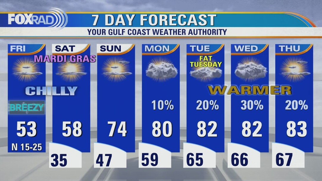
Mardi Gras in Galveston is in full effect tonight and Sunday! It won't be as cold or windy for parades tonight with temps in the 50s and wind around 10 mph or less. Look for partly sunny skies and even warmer weather Sunday in Galveston with temperatures near 70. All of SE Texas will be feeling the heat for the next several days! Houston should climb to the middle 70s Sunday with a stretch of 80s likely through next week. Rain chances will be on the low side over the next week with the best chance on Wednesday and Saturday. Patchy fog might cause a few issues early Monday & Tuesday. Enjoy the rest of your weekend!
Mardi Gras in Galveston is in full effect tonight and Sunday! It won't be as cold or windy for parades tonight with temps in the 50s and wind around 10 mph or less. Look for partly sunny skies and even warmer weather Sunday in Galveston with temperatures near 70. All of SE Texas will be feeling the heat for the next several days! Houston should climb to the middle 70s Sunday with a stretch of 80s likely through next week. Rain chances will be on the low side over the next week with the best chance on Wednesday and Saturday. Patchy fog might cause a few issues early Monday & Tuesday. Enjoy the rest of your weekend!

Saturday weather forecast with Meteorologist Lena Maria Arango
Saturday will be our last chilly day for a while, we'll begin the transition to warmer and more humid weather come Sunday. With moisture increasing at the surface, patchy fog will be possible in the mornings and by Monday some slim rain chances may emerge. The highest rain chance looks to be Wednesday, and at the moment looks mostly north of I-10. Temperatures will stay in the 80s through Go Texan Day and the BBQ Cook-Off!
Saturday will be our last chilly day for a while, we'll begin the transition to warmer and more humid weather come Sunday. With moisture increasing at the surface, patchy fog will be possible in the mornings and by Monday some slim rain chances may emerge. The highest rain chance looks to be Wednesday, and at the moment looks mostly north of I-10. Temperatures will stay in the 80s through Go Texan Day and the BBQ Cook-Off!

Saturday morning Houston-area weather forecast
Get ready for another chilly night with a light freeze possible for parts of the area, especially north of Houston around Huntsville, Livingston & Brenham. Protect any sensitive plants and make sure your pets stay warm too. It will still be breezy this evening with gusts near 20-25 mph, especially towards the coast. But wind will settle down Saturday as high pressure builds in. After a chilly start Saturday in the 30s, we will rebound to the 50s with a good amount of sunshine. Get ready for a big warming trend starting Sunday and lasting through much of next week! Near record heat is expected for parts of next week as temperatures soar into the 80s. Rain chances next week are limited but temps will be soaring so get ready! Have a safe and enjoyable weekend!
Get ready for another chilly night with a light freeze possible for parts of the area, especially north of Houston around Huntsville, Livingston & Brenham. Protect any sensitive plants and make sure your pets stay warm too. It will still be breezy this evening with gusts near 20-25 mph, especially towards the coast. But wind will settle down Saturday as high pressure builds in. After a chilly start Saturday in the 30s, we will rebound to the 50s with a good amount of sunshine. Get ready for a big warming trend starting Sunday and lasting through much of next week! Near record heat is expected for parts of next week as temperatures soar into the 80s. Rain chances next week are limited but temps will be soaring so get ready! Have a safe and enjoyable weekend!
Chilly weather sticks around Friday evening in the 50s
Get ready for another chilly night with a light freeze possible for parts of the area, especially north of Houston around Huntsville, Livingston & Brenham. Protect any sensitive plants and make sure your pets stay warm too. It will still be breezy this evening with gusts near 20-25 mph, especially towards the coast. But wind will settle down Saturday as high pressure builds in. After a chilly start Saturday in the 30s, we will rebound to the 50s with a good amount of sunshine. Get ready for a big warming trend starting Sunday and lasting through much of next week! Near record heat is expected for parts of next week as temperatures soar into the 80s. Rain chances next week are limited but temps will be soaring so get ready! Have a safe and enjoyable weekend!
Get ready for another chilly night with a light freeze possible for parts of the area, especially north of Houston around Huntsville, Livingston & Brenham. Protect any sensitive plants and make sure your pets stay warm too. It will still be breezy this evening with gusts near 20-25 mph, especially towards the coast. But wind will settle down Saturday as high pressure builds in. After a chilly start Saturday in the 30s, we will rebound to the 50s with a good amount of sunshine. Get ready for a big warming trend starting Sunday and lasting through much of next week! Near record heat is expected for parts of next week as temperatures soar into the 80s. Rain chances next week are limited but temps will be soaring so get ready! Have a safe and enjoyable weekend!

Cold, breezy Friday afternoon in the 50s
The weekend starts breezy and chilly, and ends warm and humid. Spring-like weather moves in for much of next week. In addition to toasty temps for President's Day, Fat Tuesday and the trail rides skies will be partly to mostly cloudy with a slight chance for showers or an isolated storm but overall rain chances look pretty slim.
The weekend starts breezy and chilly, and ends warm and humid. Spring-like weather moves in for much of next week. In addition to toasty temps for President's Day, Fat Tuesday and the trail rides skies will be partly to mostly cloudy with a slight chance for showers or an isolated storm but overall rain chances look pretty slim.
Houston weather: Windy and cold Friday morning, then sunny with highs only in low 50s
Bundle up! The combination of chilly temperatures and breezy north winds will keep wind chills in the 40s today with actual temps in the low 50s. For Galveston Mardi Gras tonight and Saturday, it's going to be very chilly, but a gradual warm-up begins Sunday and highs by Tuesday should reach the 70s and low 80s. Much of next week will feel like spring.
Bundle up! The combination of chilly temperatures and breezy north winds will keep wind chills in the 40s today with actual temps in the low 50s. For Galveston Mardi Gras tonight and Saturday, it's going to be very chilly, but a gradual warm-up begins Sunday and highs by Tuesday should reach the 70s and low 80s. Much of next week will feel like spring.
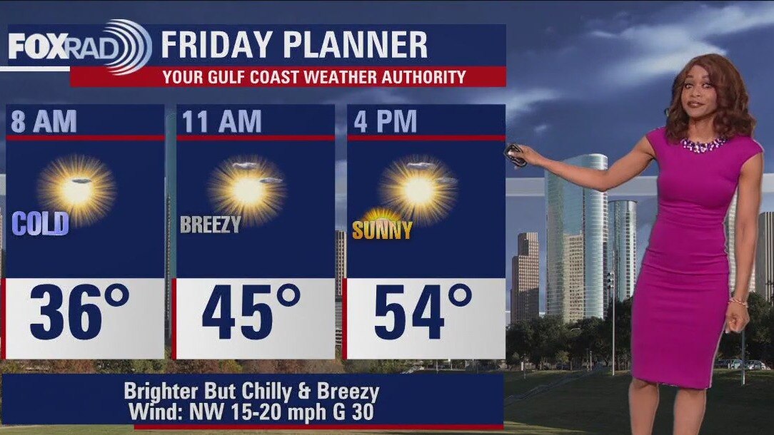
Friday morning Houston-area weather forecast
Look for a BIG jump in temps for the second half of the weekend as we soar to the 70s! Weather all weekend for Galveston Mardi Gras and any other outdoor plans should be dry with only slim rain chances Monday - Wednesday next week.
Look for a BIG jump in temps for the second half of the weekend as we soar to the 70s! Weather all weekend for Galveston Mardi Gras and any other outdoor plans should be dry with only slim rain chances Monday - Wednesday next week.
Windy, chilly Thursday evening in the 50s
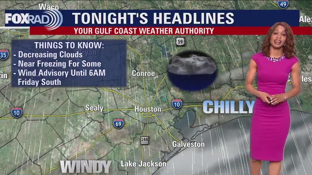
Cold front rolled across the area this morning bringing a quick round of rain & a few rumbles of thunder. Behind the front, windy & much colder conditions are building in with gusts 30-40 mph possible near the coast. That is where a WIND ADVISORY is now in place until 6 AM Friday. Make sure to secure any loose/light objects around your house. Bundle up too because much colder air is filtering in for the next few nights. Temperatures will drop to the 30s tonight and Friday night with highs only in the 50s Friday and Saturday. Look for a BIG jump in temps for the second half of the weekend as we soar to the 70s! Weather all weekend for Galveston Mardi Gras and any other outdoor plans should be dry with only slim rain chances Monday - Wednesday next week.
Cold front rolled across the area this morning bringing a quick round of rain & a few rumbles of thunder. Behind the front, windy & much colder conditions are building in with gusts 30-40 mph possible near the coast. That is where a WIND ADVISORY is now in place until 6 AM Friday. Make sure to secure any loose/light objects around your house. Bundle up too because much colder air is filtering in for the next few nights. Temperatures will drop to the 30s tonight and Friday night with highs only in the 50s Friday and Saturday. Look for a BIG jump in temps for the second half of the weekend as we soar to the 70s! Weather all weekend for Galveston Mardi Gras and any other outdoor plans should be dry with only slim rain chances Monday - Wednesday next week.