


FOX 26 Weather Forecast
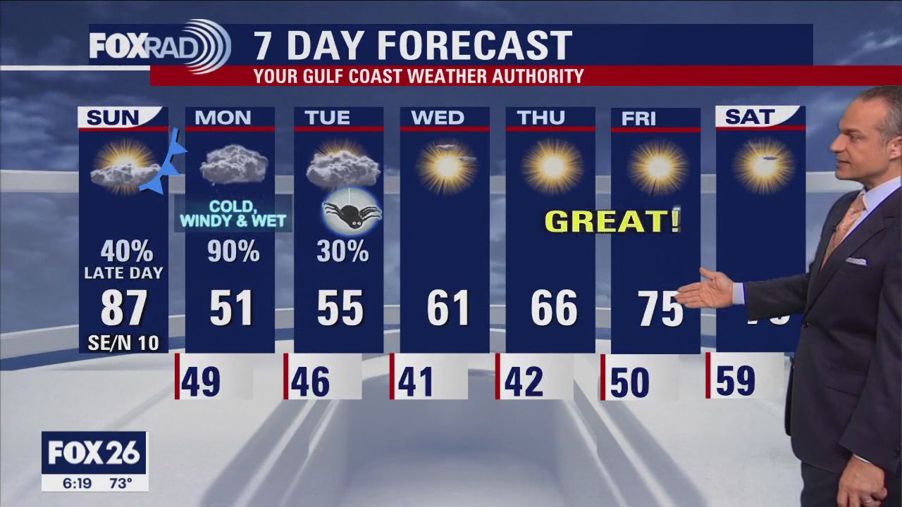
Brace yourself for some wintry air that will arrive tonight! We should hit the mid 80s today with some upper 80s possible, then a strong front this evening will drop temperatures to near 50 overnight along with wind and showers. Now, Monday will be an ugly one with rain, wind and steady temps near 50 all day. Luckily, it looks like rain should move out for trick-or-treating on Tuesday, but it will be pretty chilly. Our weather looks beautiful for Wednesday through next weekend.
Brace yourself for some wintry air that will arrive tonight! We should hit the mid 80s today with some upper 80s possible, then a strong front this evening will drop temperatures to near 50 overnight along with wind and showers. Now, Monday will be an ugly one with rain, wind and steady temps near 50 all day. Luckily, it looks like rain should move out for trick-or-treating on Tuesday, but it will be pretty chilly. Our weather looks beautiful for Wednesday through next weekend.

FOX 26 Houston Weather Forecast
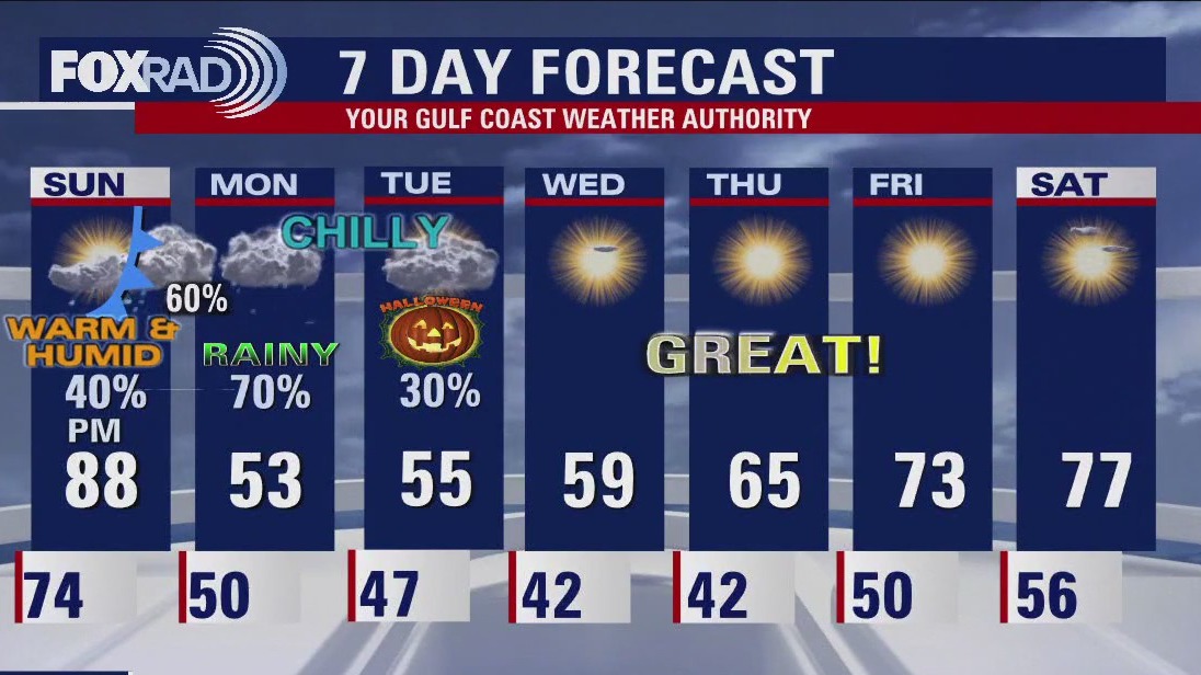
Are you ready? A huge pattern change is about to bring a major shock to the system! We stay warm and humid tonight with just an isolated shower. Look for near-record heat Sunday afternoon with high temperatures near 90. A strong cold front will be moving in by the afternoon and evening, likely between 7-8 p.m. for Houston. Scattered showers and a few storms are possible. Temperatures will start to tumble Sunday night all the way into the 50s by Monday morning. Monday will be wet, cloudy and much colder with temperatures in the low 50s much of the day, dipping to the 40s Monday night. Dress for chilly weather for Halloween this Tuesday with widespread 50s expected and temperatures in the 40s by Tuesday night. A few showers will linger early on Halloween but it should be mainly dry for trick-or-treating Tuesday night. Beautiful fall weather is expected Wednesday through Saturday with lots of sun and temperatures gradually getting warmer.
Are you ready? A huge pattern change is about to bring a major shock to the system! We stay warm and humid tonight with just an isolated shower. Look for near-record heat Sunday afternoon with high temperatures near 90. A strong cold front will be moving in by the afternoon and evening, likely between 7-8 p.m. for Houston. Scattered showers and a few storms are possible. Temperatures will start to tumble Sunday night all the way into the 50s by Monday morning. Monday will be wet, cloudy and much colder with temperatures in the low 50s much of the day, dipping to the 40s Monday night. Dress for chilly weather for Halloween this Tuesday with widespread 50s expected and temperatures in the 40s by Tuesday night. A few showers will linger early on Halloween but it should be mainly dry for trick-or-treating Tuesday night. Beautiful fall weather is expected Wednesday through Saturday with lots of sun and temperatures gradually getting warmer.


FOX 26 Houston Weather Forecast
Are you ready? A huge pattern change is about to bring a major shock to the system! We stay warm and humid tonight with just an isolated shower. Look for near record heat Sunday afternoon with high temperatures near 90. A strong cold front will be moving in by the afternoon and evening, likely between 7-8 pm for Houston. Scattered showers and a few storms are possible. Temperatures will start to tumble Sunday night all the way into the 50s by Monday morning. Monday will be wet, cloudy and much colder with temperatures in the low 50s much of the day, dipping to the 40s Monday night. Dress for chilly weather for Halloween this Tuesday with widespread 50s expected and temperatures in the 40s by Tuesday night. A few showers will linger early on Halloween but it should be mainly dry for trick-or-treating Tuesday night. Beautiful fall weather is expected Wednesday through Saturday with lots of sun and temperatures gradually getting warmer.
Are you ready? A huge pattern change is about to bring a major shock to the system! We stay warm and humid tonight with just an isolated shower. Look for near record heat Sunday afternoon with high temperatures near 90. A strong cold front will be moving in by the afternoon and evening, likely between 7-8 pm for Houston. Scattered showers and a few storms are possible. Temperatures will start to tumble Sunday night all the way into the 50s by Monday morning. Monday will be wet, cloudy and much colder with temperatures in the low 50s much of the day, dipping to the 40s Monday night. Dress for chilly weather for Halloween this Tuesday with widespread 50s expected and temperatures in the 40s by Tuesday night. A few showers will linger early on Halloween but it should be mainly dry for trick-or-treating Tuesday night. Beautiful fall weather is expected Wednesday through Saturday with lots of sun and temperatures gradually getting warmer.


FOX 26 Houston Weather Forecast
Tropical feeling air is in place today and most of Sunday with highs near records and unusually high humidity for late October. All of this comes to an abrupt end Sunday night with chilly air, rain and gusty winds. Monday looks like a washout with highs stuck in the low 50s. Plan on a chilly Halloween with trick-or-treat temps in the 50s, then beautiful fall weather beginning Wednesday.
Tropical feeling air is in place today and most of Sunday with highs near records and unusually high humidity for late October. All of this comes to an abrupt end Sunday night with chilly air, rain and gusty winds. Monday looks like a washout with highs stuck in the low 50s. Plan on a chilly Halloween with trick-or-treat temps in the 50s, then beautiful fall weather beginning Wednesday.


FOX 26 Houston Weather Forecast
Get ready for a warm weekend. The "feels like" temps will be in the 90s! But the big pattern change is still coming on Monday with the passage of a strong cold front. This blast of chilly air, wind, and rain will feel like winter for Houston. The trick or treat forecast is looking chilly and breezy. The end of next week looks pleasant and Fall like for southeast Texas.
Get ready for a warm weekend. The "feels like" temps will be in the 90s! But the big pattern change is still coming on Monday with the passage of a strong cold front. This blast of chilly air, wind, and rain will feel like winter for Houston. The trick or treat forecast is looking chilly and breezy. The end of next week looks pleasant and Fall like for southeast Texas.


FOX 26 Houston Weather Forecast
scattered showers and warm for Friday across southeast Texas. Less rain is expected for the weekend but afternoons remain warm with temperatures in the mid to upper 80s. Get ready for a very strong cold front arriving early Monday morning dropping afternoon high temps as much as 30 degrees. For now, plan for chilly, windy, wet weather on Halloween.
scattered showers and warm for Friday across southeast Texas. Less rain is expected for the weekend but afternoons remain warm with temperatures in the mid to upper 80s. Get ready for a very strong cold front arriving early Monday morning dropping afternoon high temps as much as 30 degrees. For now, plan for chilly, windy, wet weather on Halloween.


FOX 26 Houston Weather Forecast
After strong storms yesterday, steamy air will stay in place today and this weekend. Expect highs in the mid to upper 80s, which is about 10 degrees above average. Storm chances are mostly west of Houston today. Now, get ready for a huge change on Monday with a blast of chilly air, wind and rain. The trick or treat forecast is looking chilly with a chance for drizzle.
After strong storms yesterday, steamy air will stay in place today and this weekend. Expect highs in the mid to upper 80s, which is about 10 degrees above average. Storm chances are mostly west of Houston today. Now, get ready for a huge change on Monday with a blast of chilly air, wind and rain. The trick or treat forecast is looking chilly with a chance for drizzle.


FOX 26 Houston Weather Forecast
Scattered showers and warm for Friday across southeast Texas. Less rain is expected for the weekend but afternoons remain warm with temperatures in the mid to upper 80s. Get ready for a very strong cold front arriving early Monday morning dropping afternoon high temps as much as 30 degrees. For now, plan for chilly, windy, wet weather on Halloween.
Scattered showers and warm for Friday across southeast Texas. Less rain is expected for the weekend but afternoons remain warm with temperatures in the mid to upper 80s. Get ready for a very strong cold front arriving early Monday morning dropping afternoon high temps as much as 30 degrees. For now, plan for chilly, windy, wet weather on Halloween.


FOX 26 Houston Weather Forecast
Get ready for very active weather over the next several days with steamy air and scattered heavy rain today, spotty storms tomorrow and a muggy weekend with hit and miss rain. Now, find your jacket because a strong front is expected on Monday that should drop our temps by 25? along with rain and wind. For now, prepare for chilly, windy, wet weather on Halloween.
Get ready for very active weather over the next several days with steamy air and scattered heavy rain today, spotty storms tomorrow and a muggy weekend with hit and miss rain. Now, find your jacket because a strong front is expected on Monday that should drop our temps by 25? along with rain and wind. For now, prepare for chilly, windy, wet weather on Halloween.


Fox 26 Houston Weather Forecast
Get ready for very active weather over the next several days with steamy air and scattered heavy rain today, spotty storms tomorrow and a muggy weekend with hit and miss rain. Now, find your jacket because a strong front is expected on Monday that should drop our temps by 25° along with rain and wind. For now, prepare for chilly, windy, wet weather on Halloween.
Get ready for very active weather over the next several days with steamy air and scattered heavy rain today, spotty storms tomorrow and a muggy weekend with hit and miss rain. Now, find your jacket because a strong front is expected on Monday that should drop our temps by 25° along with rain and wind. For now, prepare for chilly, windy, wet weather on Halloween.


FOX 26 Houston Weather Forecast
Get ready for some rounds of rain then a HUGE temperature drop next week! Spotty rain will stick around through this evening with some brief heavy downpours possible. Widespread rain is expected Thursday, especially during the afternoon and evening. Scattered showers will stick around for Friday with only isolated rain Saturday. Rain chances pick up again Sunday night into early Monday with a very strong cold front that will usher in some chilly air by Monday and Tuesday. Plan on warm and muggy air sticking around through Sunday with temperatures in the 80s. Then a big drop is coming with a cold front early Monday that will send temperatures nearly 20 degrees below normal! It looks like Halloween will be on the chilly side with temperatures dipping into the 40s Tuesday night.
Get ready for some rounds of rain then a HUGE temperature drop next week! Spotty rain will stick around through this evening with some brief heavy downpours possible. Widespread rain is expected Thursday, especially during the afternoon and evening. Scattered showers will stick around for Friday with only isolated rain Saturday. Rain chances pick up again Sunday night into early Monday with a very strong cold front that will usher in some chilly air by Monday and Tuesday. Plan on warm and muggy air sticking around through Sunday with temperatures in the 80s. Then a big drop is coming with a cold front early Monday that will send temperatures nearly 20 degrees below normal! It looks like Halloween will be on the chilly side with temperatures dipping into the 40s Tuesday night.


Fox 26 Houston Weather Forecast
Wednesday starts several days of rain chances for southeast Texas. These showers and downpours will begin in the afternoon and continue through the evening and overnight. Drier and warmer for the weekend, with a cold front arriving very early on Monday. More rain comes with the cold front, and Houston will see a huge drop in afternoon highs. Look for max temps in the 60s for the start of next week.
Wednesday starts several days of rain chances for southeast Texas. These showers and downpours will begin in the afternoon and continue through the evening and overnight. Drier and warmer for the weekend, with a cold front arriving very early on Monday. More rain comes with the cold front, and Houston will see a huge drop in afternoon highs. Look for max temps in the 60s for the start of next week.


FOX 26 Houston Weather Forecast
Wednesday starts several days of rain chances for southeast Texas. These showers and downpours will start in the afternoon and continue through the evening and overnight. Drier and warmer for the weekend with a cold front arriving very early on Monday. More rain comes with the cold front and Houston will see a huge drop in afternoon highs. Look for max temps in the 60s for the start of next week.
Wednesday starts several days of rain chances for southeast Texas. These showers and downpours will start in the afternoon and continue through the evening and overnight. Drier and warmer for the weekend with a cold front arriving very early on Monday. More rain comes with the cold front and Houston will see a huge drop in afternoon highs. Look for max temps in the 60s for the start of next week.


FOX 26 Tuesday night weather forecast
Get ready for a big pattern change about a week from now! Warm and humid weather will stick around through the end of this week with a return to fall weather expected next week. Temperatures should stay in the 80s for highs through Sunday. Rain chances will be on the increase Wednesday with the best chance for rain Thursday. Look for isolated rain Saturday and Sunday. Monday is looking soggy, wet, windy and cooler with a strong cold front expected to drop in. Timing has shifted to this front coming in a bit earlier Monday so we may not get out of the 60s. Look for even cooler air with a few showers arriving for Halloween next Tuesday!
Get ready for a big pattern change about a week from now! Warm and humid weather will stick around through the end of this week with a return to fall weather expected next week. Temperatures should stay in the 80s for highs through Sunday. Rain chances will be on the increase Wednesday with the best chance for rain Thursday. Look for isolated rain Saturday and Sunday. Monday is looking soggy, wet, windy and cooler with a strong cold front expected to drop in. Timing has shifted to this front coming in a bit earlier Monday so we may not get out of the 60s. Look for even cooler air with a few showers arriving for Halloween next Tuesday!


FOX 26 Tuesday evening weather forecast
Get ready for a big pattern change about a week from now! Warm and humid weather will stick around through the end of this week with a return to fall weather expected next week. Temperatures should stay in the 80s for highs through Sunday. Rain chances will be on the increase Wednesday with the best chance for rain Thursday. Look for isolated rain Saturday and Sunday. Monday is looking soggy, wet, windy and cooler with a strong cold front expected to drop in. Timing has shifted to this front coming in a bit earlier Monday so we may not get out of the 60s. Look for even cooler air with a few showers arriving for Halloween next Tuesday!
Get ready for a big pattern change about a week from now! Warm and humid weather will stick around through the end of this week with a return to fall weather expected next week. Temperatures should stay in the 80s for highs through Sunday. Rain chances will be on the increase Wednesday with the best chance for rain Thursday. Look for isolated rain Saturday and Sunday. Monday is looking soggy, wet, windy and cooler with a strong cold front expected to drop in. Timing has shifted to this front coming in a bit earlier Monday so we may not get out of the 60s. Look for even cooler air with a few showers arriving for Halloween next Tuesday!


FOX 26 Houston Weather Forecast
Warm and muggy remain in the forecast this week with mid to upper 80s across southeast Texas this afternoon. Rain chances increase on Wednesday. More rain expected for Thursday and Friday with most of that showers and light rain. A strong cold front should arrive to Houston on Monday, helping to make Halloween feel more like fall.
Warm and muggy remain in the forecast this week with mid to upper 80s across southeast Texas this afternoon. Rain chances increase on Wednesday. More rain expected for Thursday and Friday with most of that showers and light rain. A strong cold front should arrive to Houston on Monday, helping to make Halloween feel more like fall.


FOX 26 Houston Weather Forecast
Warm and muggy weather will stick around through much of this week with increasing rain chances. We will stay in the 80s during the afternoon with lots of humidity. Tuesday is mainly dry but rain chances are higher Wednesday through Friday. Thursday appears to be our best chance for more widespread rain. Warm temperatures and a few showers will linger for your weekend plans. A much bigger pattern change is set to arrive early next week with a stronger cold front. late Monday into Tuesday. This front will bring a better chance for rain and a big drop in temperatures just in time for Halloween...stay tuned for updates!
Warm and muggy weather will stick around through much of this week with increasing rain chances. We will stay in the 80s during the afternoon with lots of humidity. Tuesday is mainly dry but rain chances are higher Wednesday through Friday. Thursday appears to be our best chance for more widespread rain. Warm temperatures and a few showers will linger for your weekend plans. A much bigger pattern change is set to arrive early next week with a stronger cold front. late Monday into Tuesday. This front will bring a better chance for rain and a big drop in temperatures just in time for Halloween...stay tuned for updates!