


FOX 26 Houston Weather Forecast
Sunday starts off with some fog and cloudy skies but some sun should return to the skies late in the afternoon. A weak, dry front will cross into southeast Texas and decrease the humidity for the start of the workweek. Not much rain expected this week in Houston and temperatures will be seasonal for the first week of December. Warmer temps and rain chances return for next weekend
Sunday starts off with some fog and cloudy skies but some sun should return to the skies late in the afternoon. A weak, dry front will cross into southeast Texas and decrease the humidity for the start of the workweek. Not much rain expected this week in Houston and temperatures will be seasonal for the first week of December. Warmer temps and rain chances return for next weekend


FOX 26 Houston Weather Forecast
Mostly cloudy across the Houston area on Saturday. Isolated showers will be possible as a cold front slides into southeast Texas. Partly cloudy skies arrive for the end of the weekend and start a nice stretch of weather for all your early December outdoor activities.
Mostly cloudy across the Houston area on Saturday. Isolated showers will be possible as a cold front slides into southeast Texas. Partly cloudy skies arrive for the end of the weekend and start a nice stretch of weather for all your early December outdoor activities.


FOX 26 Houston Weather Forecast
Temperatures look comfortable ahead of the Texans-Broncos game on Sunday. Mostly cloudy across the Houston area on Saturday. Isolated showers will be possible as a cold front slides into southeast Texas. Partly cloudy skies arrive for the end of the weekend and start a nice stretch of weather for all your early December outdoor activities.
Temperatures look comfortable ahead of the Texans-Broncos game on Sunday. Mostly cloudy across the Houston area on Saturday. Isolated showers will be possible as a cold front slides into southeast Texas. Partly cloudy skies arrive for the end of the weekend and start a nice stretch of weather for all your early December outdoor activities.


FOX 26 Houston Weather Forecast
Mostly cloudy across the Houston area on Saturday. Isolated showers will be possible as a cold front slides into southeast Texas. Partly cloudy skies arrive for the end of the weekend and starts a nice stretch of weather for all your early December outdoor activities.
Mostly cloudy across the Houston area on Saturday. Isolated showers will be possible as a cold front slides into southeast Texas. Partly cloudy skies arrive for the end of the weekend and starts a nice stretch of weather for all your early December outdoor activities.

FOX 26 Houston Weather Forecast
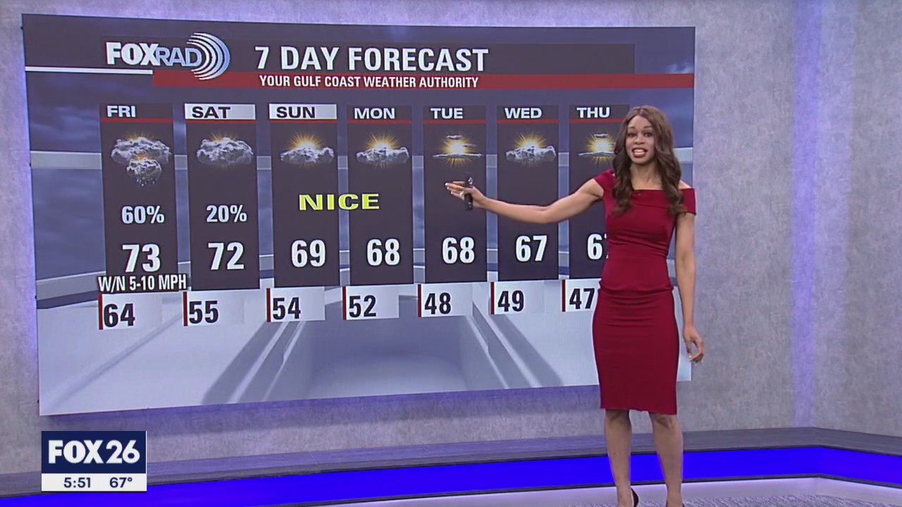
Scattered showers and a few storms will linger through early tonight, fading during the overnight hours. Once again, there is a chance for some patchy dense fog early Saturday with isolated mainly light rain during the day. The rain chance Saturday is only 20%. So don't cancel any outdoor plans! Clouds will stay on the thicker side Saturday but look for more sunshine Sunday and Monday. In fact, a stretch of pleasant, quiet, and dry weather is expected for much of next week.
Scattered showers and a few storms will linger through early tonight, fading during the overnight hours. Once again, there is a chance for some patchy dense fog early Saturday with isolated mainly light rain during the day. The rain chance Saturday is only 20%. So don't cancel any outdoor plans! Clouds will stay on the thicker side Saturday but look for more sunshine Sunday and Monday. In fact, a stretch of pleasant, quiet, and dry weather is expected for much of next week.


FOX 26 Houston Weather Forecast
Scattered showers and a few storms will linger through early tonight, fading during the overnight hours. Once again, there is a chance for some patchy dense fog early Saturday with isolated mainly light rain during the day. Rain chance Saturday is only 20%. So don't cancel any outdoor plans! Clouds will stay on the thicker side Saturday but look for more sunshine Sunday and Monday. In fact, a stretch of pleasant, quiet and dry weather is expected for much of next week.
Scattered showers and a few storms will linger through early tonight, fading during the overnight hours. Once again, there is a chance for some patchy dense fog early Saturday with isolated mainly light rain during the day. Rain chance Saturday is only 20%. So don't cancel any outdoor plans! Clouds will stay on the thicker side Saturday but look for more sunshine Sunday and Monday. In fact, a stretch of pleasant, quiet and dry weather is expected for much of next week.


FOX 26 Houston Weather Forecast
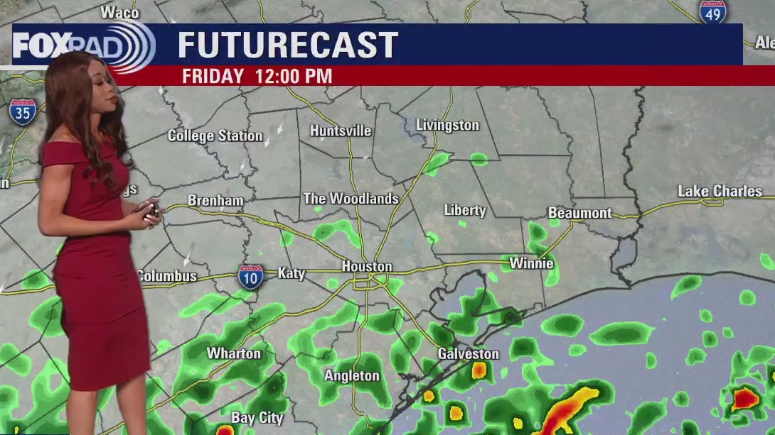
Yesterday brought record rainfall of nearly 4" to Galveston and 1.75" at Hobby Airport. Today will be cloudy and misty with a chance for quick-moving afternoon storms, especially closer to the coast. For the weekend, Saturday looks mostly cloudy with a few drizzles, then a great pattern begins Sunday.
Yesterday brought record rainfall of nearly 4" to Galveston and 1.75" at Hobby Airport. Today will be cloudy and misty with a chance for quick-moving afternoon storms, especially closer to the coast. For the weekend, Saturday looks mostly cloudy with a few drizzles, then a great pattern begins Sunday.

FOX 26 Houston Weather Forecast
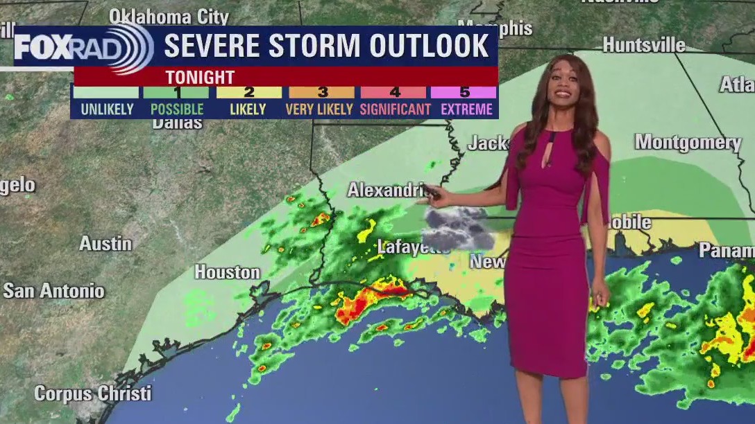
Overall, the severe threat is lower than earlier today and should wind down by early tonight. Rounds of rain helped to limit heating and instability even though we had lots of spin in the atmosphere. But stay alert because there could still be an isolated strong to severe storm through early tonight. Wind gusts near 50-60 mph and heavy rain that could lead to flooding are the main threats. Tornado risk is only around 2-5%. We should briefly dry out overnight through much of Friday morning. But a cold front will likely stall near us Friday and that will help to kick off another round of showers and storms Friday afternoon. These storms are not expected to be severe. But some heavy downpours are once again possible. At least things calm down for the weekend with pleasant temperatures and only a slim chance for a shower Saturday.
Overall, the severe threat is lower than earlier today and should wind down by early tonight. Rounds of rain helped to limit heating and instability even though we had lots of spin in the atmosphere. But stay alert because there could still be an isolated strong to severe storm through early tonight. Wind gusts near 50-60 mph and heavy rain that could lead to flooding are the main threats. Tornado risk is only around 2-5%. We should briefly dry out overnight through much of Friday morning. But a cold front will likely stall near us Friday and that will help to kick off another round of showers and storms Friday afternoon. These storms are not expected to be severe. But some heavy downpours are once again possible. At least things calm down for the weekend with pleasant temperatures and only a slim chance for a shower Saturday.

FOX 26 Houston Weather Forecast
Evening Weather Web Update - Overall, the severe threat is lower than earlier today and should wind down by early tonight. Rounds of rain helped to limit heating and instability even though we had lots of spin in the atmosphere. But stay alert because there could still be an isolated strong to severe storm through early tonight. Wind gusts near 50-60 mph and heavy rain that could lead to flooding are the main threats. Tornado risk is only around 2-5%. We should briefly dry out overnight through much of Friday morning. But a cold front will likely stall near us Friday and that will help to kick off another round of showers and storms Friday afternoon. These storms are not expected to be severe. But some heavy downpours are once again possible. At least things calm down for the weekend with pleasant temperatures and only a slim chance for a shower Saturday.
Evening Weather Web Update - Overall, the severe threat is lower than earlier today and should wind down by early tonight. Rounds of rain helped to limit heating and instability even though we had lots of spin in the atmosphere. But stay alert because there could still be an isolated strong to severe storm through early tonight. Wind gusts near 50-60 mph and heavy rain that could lead to flooding are the main threats. Tornado risk is only around 2-5%. We should briefly dry out overnight through much of Friday morning. But a cold front will likely stall near us Friday and that will help to kick off another round of showers and storms Friday afternoon. These storms are not expected to be severe. But some heavy downpours are once again possible. At least things calm down for the weekend with pleasant temperatures and only a slim chance for a shower Saturday.

FOX 26 Houston Weather Forecast for Thursday
Thursday is a FOX 26 Storm Alert Day with a severe weather threat moving into the Houston area and Southeast Texas. A strong storm system will bring the threat for a few tornadoes, large hail, heavy rain and damaging winds.
Thursday is a FOX 26 Storm Alert Day with a severe weather threat moving into the Houston area and Southeast Texas. A strong storm system will bring the threat for a few tornadoes, large hail, heavy rain and damaging winds.


Houston weather: Severe storm, tornado outlook
A strong storm system will bring the threat for a few tornadoes, large hail, heavy rain and damaging winds to Southeast Texas on Thursday.
A strong storm system will bring the threat for a few tornadoes, large hail, heavy rain and damaging winds to Southeast Texas on Thursday.

FOX 26 Houston Weather Forecast for Thursday
The NOAA Storm Prediction Center updated their severe outlook for today at 7 a.m. They have maintained their enhanced area for tornadoes, hail and damaging winds and even moved the area slightly south to include Houston and just about all the surrounding suburbs. Action should pick up by 9 a.m. and get ugly late morning through the afternoon.
The NOAA Storm Prediction Center updated their severe outlook for today at 7 a.m. They have maintained their enhanced area for tornadoes, hail and damaging winds and even moved the area slightly south to include Houston and just about all the surrounding suburbs. Action should pick up by 9 a.m. and get ugly late morning through the afternoon.

FOX 26 Houston Weather Forecast for Thursday
Thursday is a FOX 26 Storm Alert Day. Expect light rain and drizzle early this morning, but then scattered heavy downpours and some severe storms from mid morning through mid afternoon.
Thursday is a FOX 26 Storm Alert Day. Expect light rain and drizzle early this morning, but then scattered heavy downpours and some severe storms from mid morning through mid afternoon.

FOX 26 Houston Weather Forecast
Rounds of storms will roll through Houston early Thursday and will continue through Thursday evening with the severe threat expected to shift east by Thursday night. Periods of showers/thunderstorms can be expected to develop across SE TX and Houston. There is a risk for strong and/or severe storms & locally heavy rain, mainly late morning thru early evening.
Rounds of storms will roll through Houston early Thursday and will continue through Thursday evening with the severe threat expected to shift east by Thursday night. Periods of showers/thunderstorms can be expected to develop across SE TX and Houston. There is a risk for strong and/or severe storms & locally heavy rain, mainly late morning thru early evening.


FOX 26 Houston Weather Forecast
Rounds of storms will roll through Houston early Thursday and will continue through Thursday evening with the severe threat expected to shift east by Thursday night.
Rounds of storms will roll through Houston early Thursday and will continue through Thursday evening with the severe threat expected to shift east by Thursday night.

FOX 26 Houston Weather Forecast
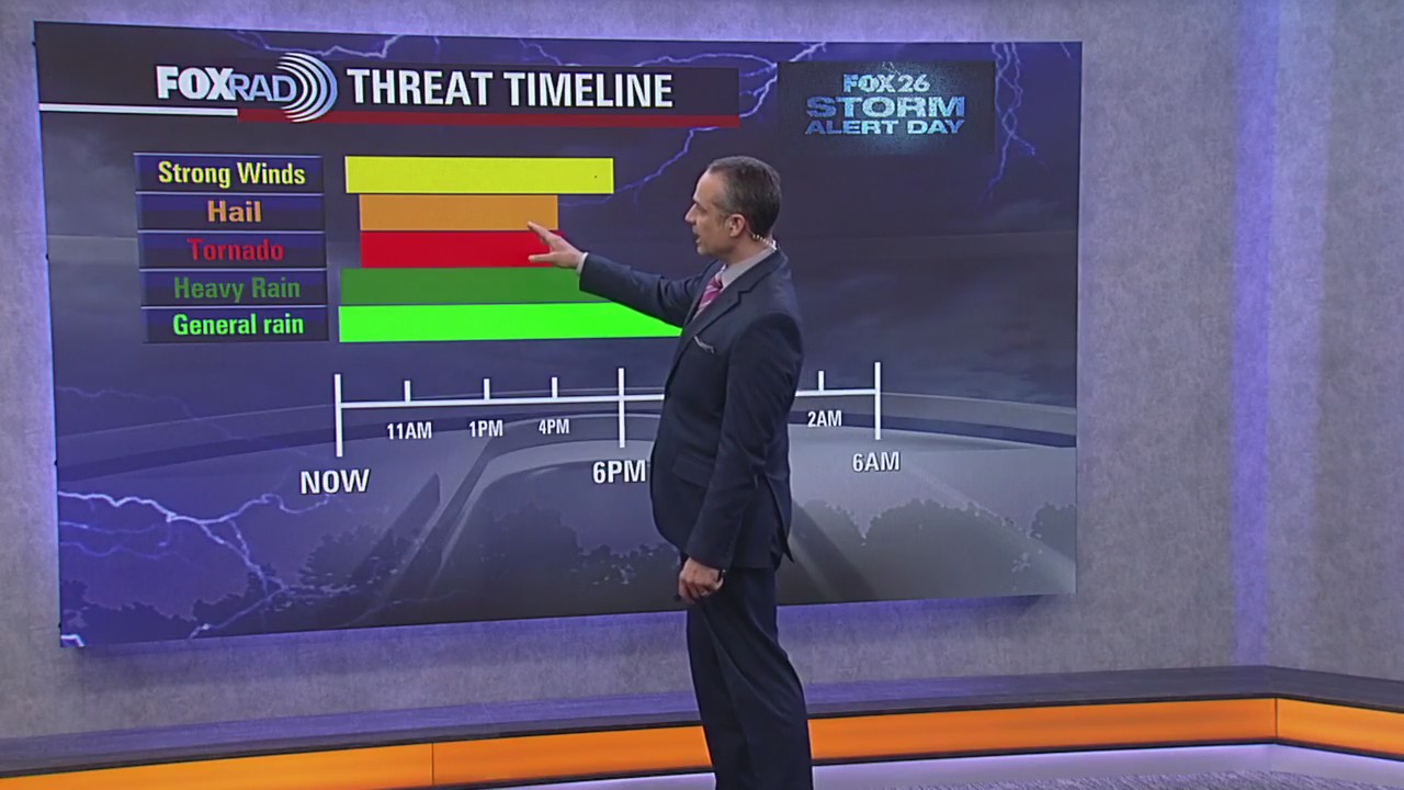
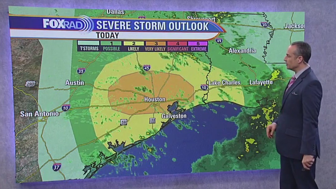
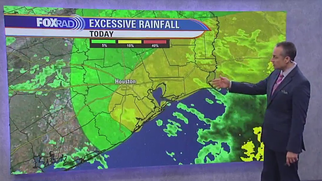
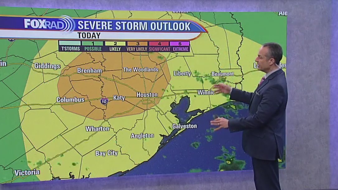
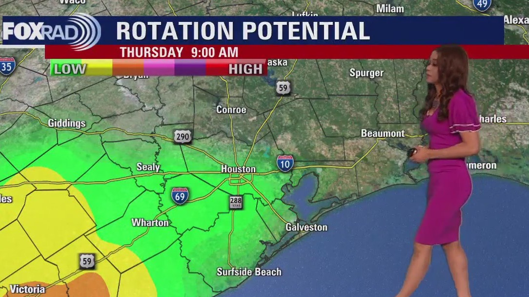
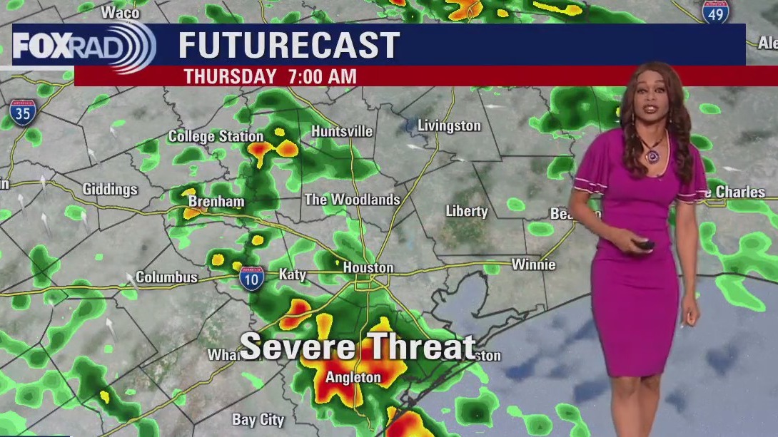
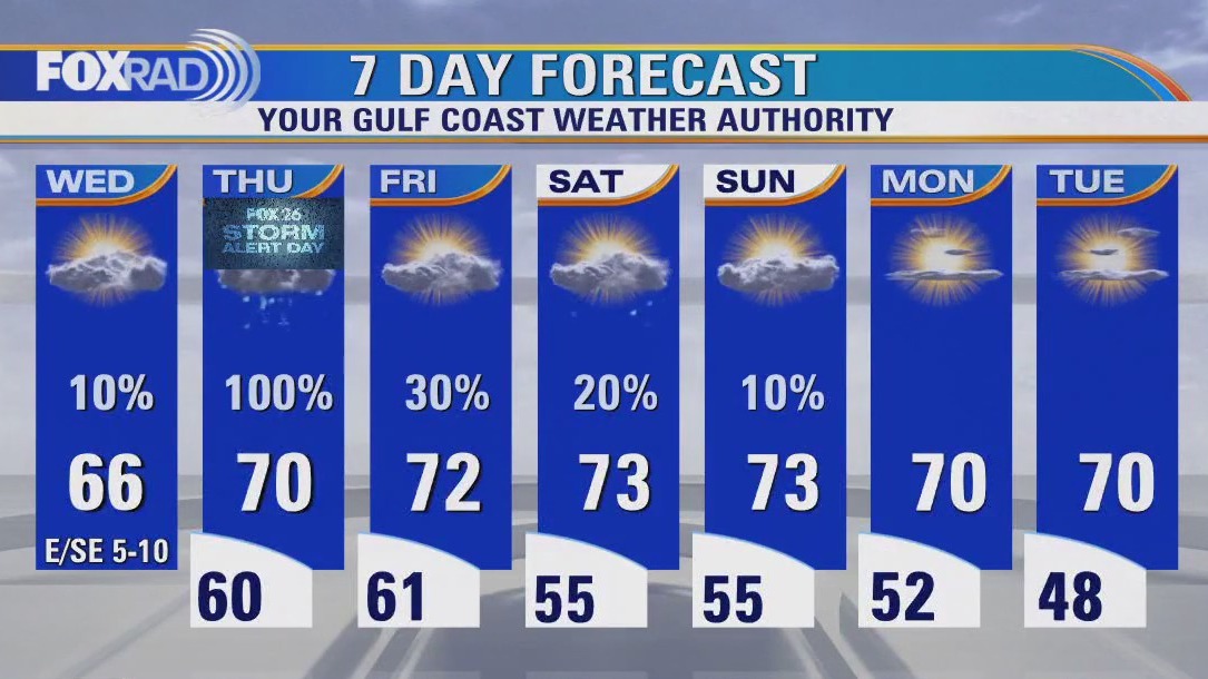
Stay alert Thursday as a big severe weather threat is expected to move into the SE Texas area! Strong storm system will bring the threat for a few tornadoes, large hail, heavy rain and damaging winds. Showers will increase overnight with the main window for severe storms from mid-late morning Thursday through Thursday afternoon. Areas south of I-10 are under a category 2 out of 5 risk for severe storms Thursday with areas north of I-10 under an even higher category 3 out of 5 risk for severe weather. Areas in the highest risk include Katy, Conroe, The Woodlands, Huntsville and Livingston. We will likely have a tornado watch or severe thunderstorm watch issued Thursday. So be ready to get inside a sturdy building on the lowest level in case warnings are issued. Rounds of storms will continue through Thursday evening with the severe threat expected to shift east by Thursday night. We also have a marginal risk for excessive rain that could lead to some street flooding. 1-2" of rain is expected with Thursday's system. Lower rain chances will linger through the weekend. We dry out out and cool off a bit next week. Make sure to download our FOX 26 Weather App and turn the alerts on to keep track of the severe weather threat!
Stay alert Thursday as a big severe weather threat is expected to move into the SE Texas area! Strong storm system will bring the threat for a few tornadoes, large hail, heavy rain and damaging winds. Showers will increase overnight with the main window for severe storms from mid-late morning Thursday through Thursday afternoon. Areas south of I-10 are under a category 2 out of 5 risk for severe storms Thursday with areas north of I-10 under an even higher category 3 out of 5 risk for severe weather. Areas in the highest risk include Katy, Conroe, The Woodlands, Huntsville and Livingston. We will likely have a tornado watch or severe thunderstorm watch issued Thursday. So be ready to get inside a sturdy building on the lowest level in case warnings are issued. Rounds of storms will continue through Thursday evening with the severe threat expected to shift east by Thursday night. We also have a marginal risk for excessive rain that could lead to some street flooding. 1-2" of rain is expected with Thursday's system. Lower rain chances will linger through the weekend. We dry out out and cool off a bit next week. Make sure to download our FOX 26 Weather App and turn the alerts on to keep track of the severe weather threat!

FOX 26 Houston Weather Forecast
Stay alert Thursday as a big severe weather threat is expected to move into the SE Texas area! Strong storm system will bring the threat of a few tornadoes, large hail, heavy rain, and damaging winds. Showers will increase overnight with the main window for severe storms from mid-late morning Thursday through Thursday afternoon. Areas south of I-10 are under a category 2 out of 5 risk for severe storms Thursday with areas north of I-10 under an even higher category 3 out of 5 risk for severe weather. Areas in the highest risk include Katy, Conroe, The Woodlands, Huntsville and Livingston. We will likely have a tornado watch or severe thunderstorm watch issued Thursday. So be ready to get inside a sturdy building on the lowest level in case warnings are issued. Rounds of storms will continue through Thursday evening with the severe threat expected to shift east by Thursday night. We also have a marginal risk of excessive rain that could lead to some street flooding. 1-2" of rain is expected with Thursday's system. Lower rain chances will linger through the weekend. We dry out and cool off a bit next week. Make sure to download our FOX 26 Weather App and turn the alerts on to keep track of the severe weather threat!
Stay alert Thursday as a big severe weather threat is expected to move into the SE Texas area! Strong storm system will bring the threat of a few tornadoes, large hail, heavy rain, and damaging winds. Showers will increase overnight with the main window for severe storms from mid-late morning Thursday through Thursday afternoon. Areas south of I-10 are under a category 2 out of 5 risk for severe storms Thursday with areas north of I-10 under an even higher category 3 out of 5 risk for severe weather. Areas in the highest risk include Katy, Conroe, The Woodlands, Huntsville and Livingston. We will likely have a tornado watch or severe thunderstorm watch issued Thursday. So be ready to get inside a sturdy building on the lowest level in case warnings are issued. Rounds of storms will continue through Thursday evening with the severe threat expected to shift east by Thursday night. We also have a marginal risk of excessive rain that could lead to some street flooding. 1-2" of rain is expected with Thursday's system. Lower rain chances will linger through the weekend. We dry out and cool off a bit next week. Make sure to download our FOX 26 Weather App and turn the alerts on to keep track of the severe weather threat!

FOX 26 Houston Weather Forecast
Today will be the literal "calm before the storm" as we expect an outbreak of strong to severe storms tomorrow. Clouds will increase gradually today with highs in the mid to upper 60s, but should remain dry. Storms are likely by tomorrow morning with severe weather possible for the morning commute and through at least early afternoon. High winds and even tornadoes will be possible. Storm chances fall on Friday with isolated showers possible followed by a nice-looking weekend.
Today will be the literal "calm before the storm" as we expect an outbreak of strong to severe storms tomorrow. Clouds will increase gradually today with highs in the mid to upper 60s, but should remain dry. Storms are likely by tomorrow morning with severe weather possible for the morning commute and through at least early afternoon. High winds and even tornadoes will be possible. Storm chances fall on Friday with isolated showers possible followed by a nice-looking weekend.

FOX 26 Houston Weather Forecast
It's been a nice weather day across Houston with some nice sunshine and dry weather. Get ready for another cool and dry night with temperatures dipping into the 40s for the Houston area. Clouds get thicker Wednesday but the rain for the most part should hold off until Wednesday night and Thursday. Thursday looks like a washout with rounds of heavy rain in the morning through the evening. A few strong to severe storms may also develop and we have a category 2 out of 5 risk for severe weather Thursday. That means storms with a few tornadoes, damaging winds and large hail could push across the area. So download our FOX 26 Weather App and stay alert for watches and warnings. A few showers stick around Friday through the weekend with temperatures getting a little cooler early next week.
It's been a nice weather day across Houston with some nice sunshine and dry weather. Get ready for another cool and dry night with temperatures dipping into the 40s for the Houston area. Clouds get thicker Wednesday but the rain for the most part should hold off until Wednesday night and Thursday. Thursday looks like a washout with rounds of heavy rain in the morning through the evening. A few strong to severe storms may also develop and we have a category 2 out of 5 risk for severe weather Thursday. That means storms with a few tornadoes, damaging winds and large hail could push across the area. So download our FOX 26 Weather App and stay alert for watches and warnings. A few showers stick around Friday through the weekend with temperatures getting a little cooler early next week.