

Houston weather: Mild night Monday before rain, cold moves in later this week
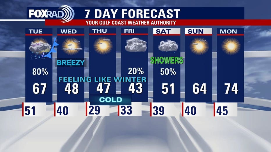
HOUSTON - Houston can expect increasing clouds Monday night into Tuesday morning with temperatures hovering in the lower 50s.
COLD FRONT ARRIVES LATE TUESDAY
All eyes will be on our next cold front which will sweep across SE Texas on Tuesday evening. Ahead of the front, temperatures will rise to the upper-60s. Along the front, there is a one out of five risk for heavy rain and strong storms. The main weather concerns ahead and along the front will be pockets of heavy rain, lightning, and strong wind gusts.
WINDY WEDNESDAY
Cold air rushes into Southeast Texas behind the front Tuesday night into Wednesday morning. Brazos, Colorado, Grimes, Houston, Madison, Trinity, Walker, and Washing Counties are under a cold weather advisory from 3 a.m. to 10 a.m. on Wednesday. Wind chill, or feels like temperatures, could be as low as 17 to 20 degrees. Use caution when outdoors and wear appropriate clothing, including a hat and gloves.
FREEZING TEMPERATURES LATE WEEK
Once the cold front clears, arctic air will dominate the region through the end of the week. A freeze is likely Thursday morning as temperatures will drop to the 20s/below freezing with wind chill values in the teens. Remember the 4 P's- People, Pets, Plants and Pipes.
Download the free FOX Local app on your phone and Smart TV to stay up-to-date on the latest weather where you live.