

Tropical Storm Beta forecast to make landfall along Texas coast on Monday
HOUSTON - Tropical Storm Beta is moving toward the central Texas coast and is expected to make landfall on Monday.
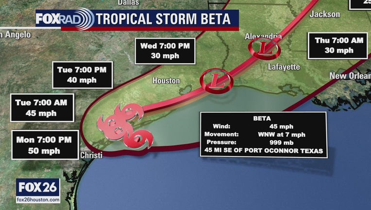
Beta is expected to slowly move up the Texas coast this week. The primary hazards are coastal flooding with a 3-4 foot storm surge and isolated bands of very heavy rain.
Beta has maximum sustained winds of 45 mph, with higher gusts. According to the National Hurricane Center, little change in strength is forecast before Beta reaches the coast.
Beta is located about 65 miles south-southwest of Freeport and about 45 miles southeast of Port O’Connor on Monday morning.
The tropical storm is moving toward the west-northwest near 7 mph, and that general motion is expected to continue on Monday. According to the NHC, a decrease in forward speed and a sharp turn to the north and northeast are expected on Tuesday.
The NHC says the center of Beta will likely move inland by Monday night, and Beta is forecast to remain close to the southeast Texas coast on Tuesday and Wednesday.
Beta is expected to weaken once it moves inland.
MORE TROPICAL WEATHER FORECASTS FROM FOX 26
WATCHES AND WARNINGS
A Flash Flood Watch is in effect through Tuesday evening for the following counties:
- Austin, Brazoria, Chambers, Colorado, Fort Bend, Galveston, Harris, Jackson, Matagorda, Montgomery, Liberty, Waller and Wharton.
According to the National Weather Service, prolonged heavy rainfall from Tropical Storm Beta will have the potential to produce rainfall totals averaging 5 to 10 inches with isolated amounts around 15 inches as the system slows down after moving inland.
A Storm Surge Warning is now in effect for:
- Port Aransas, Texas to Sabine Pass, Texas including Copano Bay, Aransas Bay, San Antonio Bay, Matagorda Bay, and Galveston Bay
A Tropical Storm Warning is in effect for:
- Port Aransas, Texas to Morgan City, Louisiana
A Tropical Storm Watch is in effect for:
- Baffin Bay to Port Aransas, Texas
CLICK HERE FOR YOUR HURRICANE QUICKLIST

HCFCD Meteorologist Jeff Lindner discusses Tropical Storm Beta
Jeff Lindner, meteorologist with the Harris County Flood Control District, is monitoring Tropical Storm Beta. He discusses the effects of the tropical storm.
VOLUNTARY EVACUATIONS ISSUED
BRAZORIA COUNTY
Brazoria County Judge Matt Sebesta has issued a voluntary evacuation for low-lying coastal areas. See below:
CHAMBERS COUNTY
Seabrook Mayor Thom Kolupski has issued a voluntary evacuation for residents and businesses in low-lying areas in Seabrook, specifically lower Todville from Red Bluff south to State Highway 146 and Baywood Drive.
Chambers County Judge Jimmy Slyvia has also issued a voluntary evacuation warning ahead of the storm.
GALVESTON COUNTY
Galveston County Judge Mark Henry has issued a voluntary evacuation order for the Bolivar Peninsula in preparation for Tropical Storm Beta. Residents are strongly encouraged to seek safety further inland for the duration of the storm. Henry added that the peninsula could become cut off from the rest of the county and emergency services could be impacted. Elevated tides are expected to be four to six feet starting on Saturday evening and lasting until mid-week.
City of Galveston Mayor ProTemp Craig Brown has issued a voluntary evacuation of the West End (west of the Seawall) and low-lying areas of the island in response to the high tides and rainfall expected.
LIBERTY COUNTY
Liberty County has issued a voluntary evacuation is being recommended for persons living in flood-prone and low-lying areas of Liberty County.
MATAGORDA COUNTY
The Matagorda County Emergency Operations Center has issued a voluntary evacuation recommendation for the community of Sargent, the township of Matagorda, and the bayfront area of the City of Palacio.
SCHOOL CLOSURES
FOX 26 is continuing to keep a list of closures as they come in. Click here for the latest list.
FERRY SERVICE
Galveston Ferry suspended services due to high tide conditions on Sunday morning.
What’s in a (tropical) name, anyway?
With the development of a subtropical storm off the coast of Portugal Friday morning {Alpha}, the Atlantic Hurricane Season took another historic turn and transitioned over to the Greek alphabet for naming tropical cyclones in the Atlantic basin. Only one other time has the Greek alphabet been used when naming tropical cyclones in the Atlantic basin and that was 2005.
The name ‘Wilfred’ was last on the list for Atlantic storm names for the 2020 season, completing the English alphabet where nearly all letters are assigned a corresponding name. The only letters left out the naming process are Q, U, X, Y, and Z.
MORE: Tropical Storm Wilfred forms in Atlantic, using final name on NHC's 2020 list
So what’s in a name anyway? The World Meteorological Organization (WMO) is in charge of naming tropical cyclones all over the globe. The practice of naming tropical cyclones began since it seemed easier to identify storm-systems in tropics. According to the WMO’s website, ‘Experience shows that the use of short, distinctive given names in written as well as spoken communications is quicker and less subject to error than the older more cumbersome latitude-longitude identification methods.”
Since 1953, Atlantic tropical cyclones have been named from lists originated by the National Hurricane Center. Those names are now controlled and updated by an international committee of the WMO. Interesting to note, the original name lists were only female names. Male names were introduced in 1979 and they now alternate with the female names. According to the WMO, six lists are used in rotation, thus the 2020 list will be used again in 2026 unless a name is retired.
It is often the case that a particular tropical cyclone is exceptionally damaging or costly, in which case the WMO reserves the right to retire a name. This is done simply because the WMO believes it would be ‘inappropriate for reasons of sensitivity.’ Names such as Harvey, Rita, Ike, Maria, and Sandy have all been retired. These infamous names will go down in history due to their impact on human life and property.
Now that we have exhausted the names associated with the English alphabet, we go Greek. We’re not totally in uncharted territory, though. In 2005, we saw six storms assigned to their respective Greek-letter so the question remains how deep into the Greek alphabet will we go. The Atlantic Hurricane Season doesn’t officially end until November 30 so we still have plenty of time to see more named-storms.
MORE INFO: What happens if we run out of hurricane names?
The FOX 26 Weather Team is closely monitoring developments. They will continue to keep you up-to-date online, on-air, and on social media.
You can also stay up-to-date 24 hours a day by downloading the free FOX 26 weather app. You'll receive weather alerts for your location, along with video weather updates.