

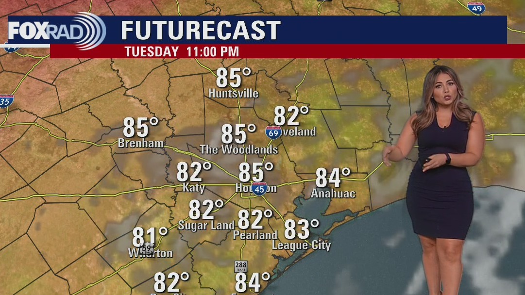

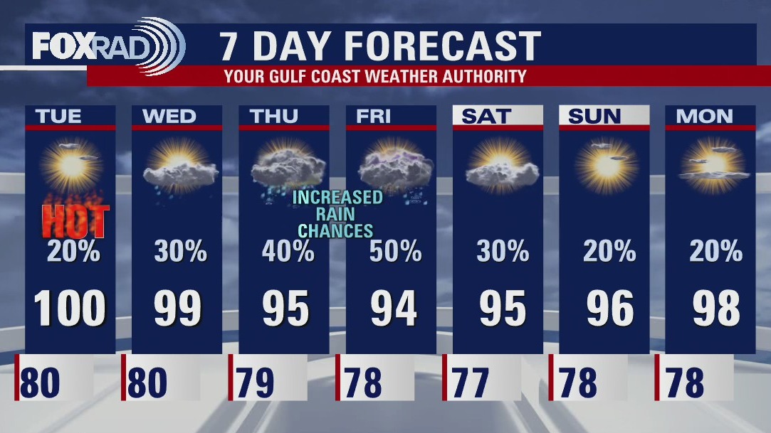
Tuesday evening weather forecast
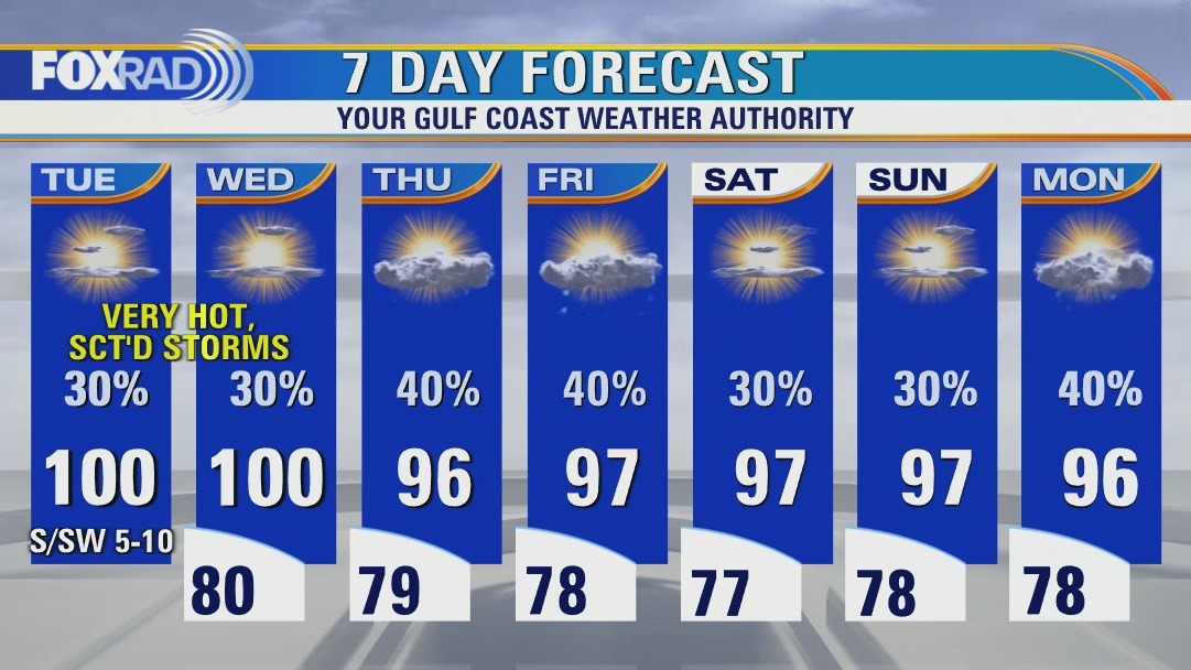
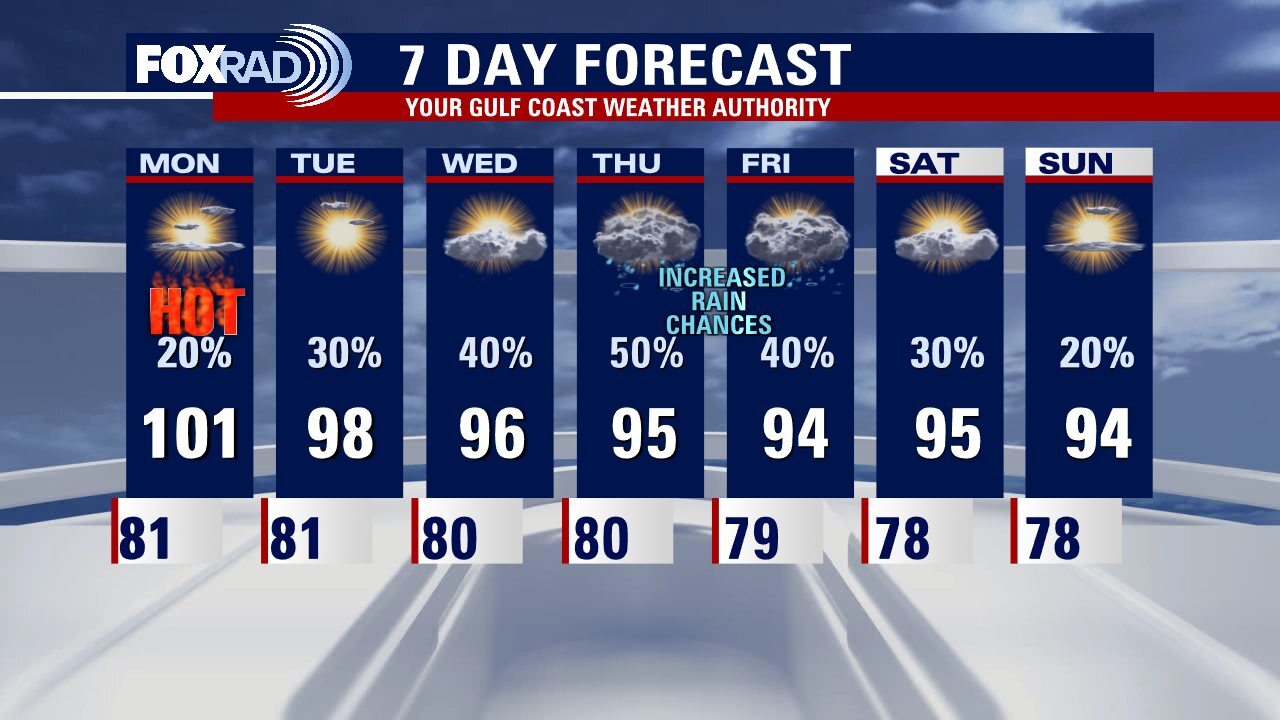
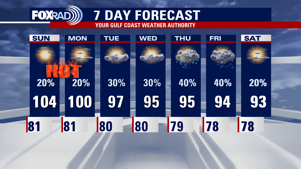
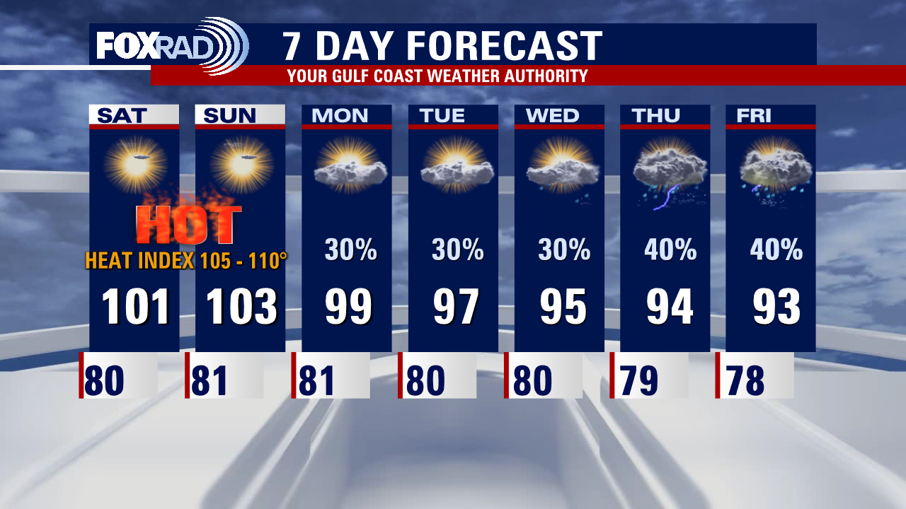
As we continue through the rest of the week, a slightly less intense version of heat looks to continue. Some of us may squeeze out another 100-degree day or two especially farther inland. At least scattered shower and storm chances remain in the forecast daily! While still above average, enjoy the slightly subdued temperatures while they last. More 100s look apparent in our near future with another hot and dry pattern on the horizon.
As we continue through the rest of the week, a slightly less intense version of heat looks to continue. Some of us may squeeze out another 100-degree day or two especially farther inland. At least scattered shower and storm chances remain in the forecast daily! While still above average, enjoy the slightly subdued temperatures while they last. More 100s look apparent in our near future with another hot and dry pattern on the horizon.

Tropical Weather Forecast - July 12, 2022
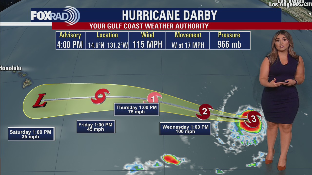
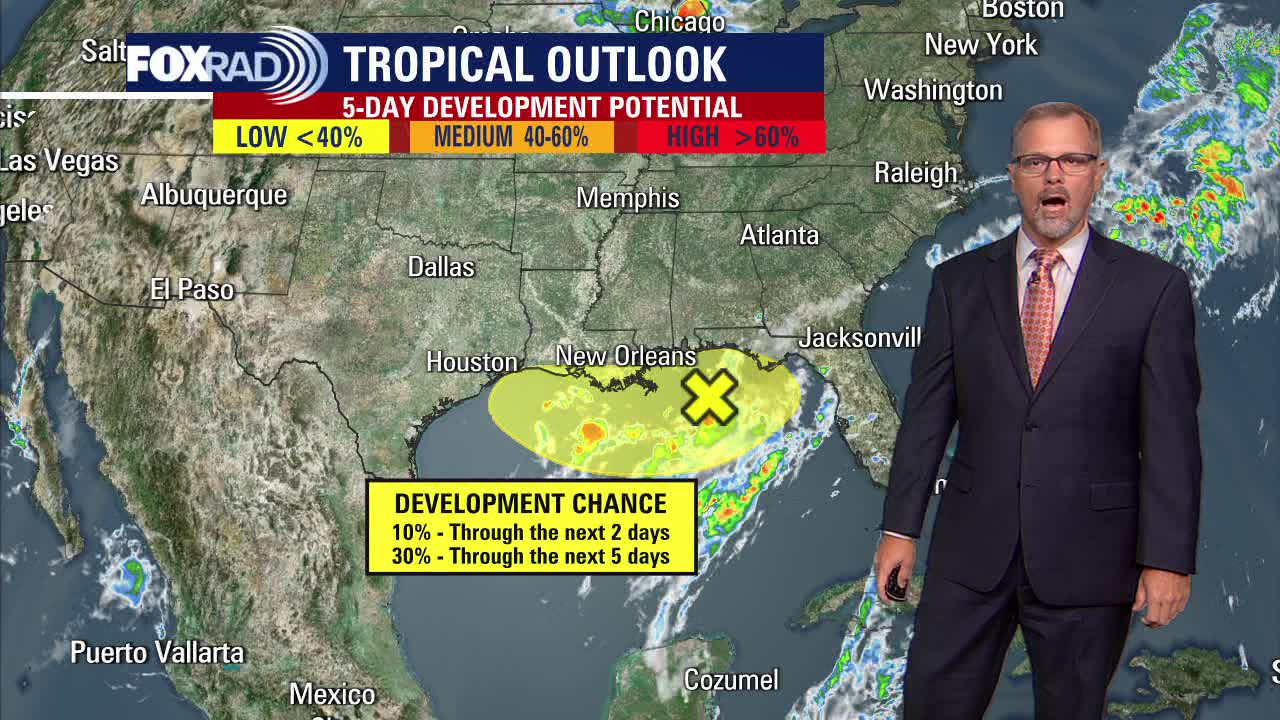
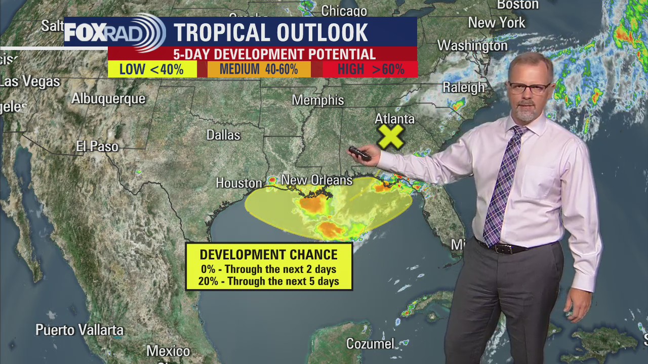
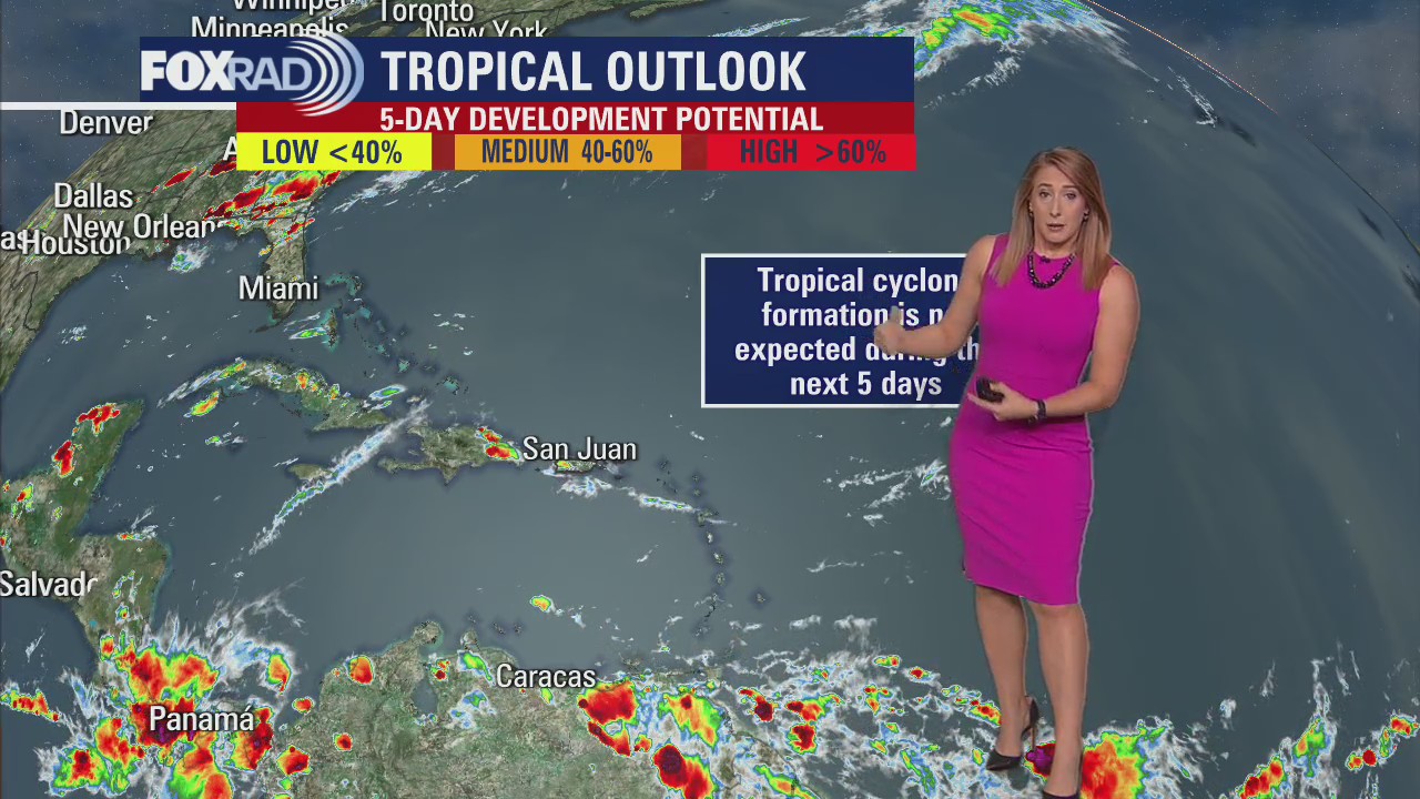
In the Atlantic, we continue to monitor a stationary broad trough of low pressure in the northern Gulf of Mexico. While organization and development opportunities remain low, heavy rainfall is possible along coastal Louisiana through the Florida Panhandle. In the Pacific, Darby continues to churn westward as a major hurricane with one other area being monitored for development at this time.
In the Atlantic, we continue to monitor a stationary broad trough of low pressure in the northern Gulf of Mexico. While organization and development opportunities remain low, heavy rainfall is possible along coastal Louisiana through the Florida Panhandle. In the Pacific, Darby continues to churn westward as a major hurricane with one other area being monitored for development at this time.

Very hot again Tuesday with some storms
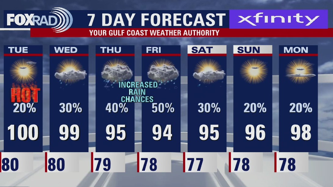
Still no rest for the weary...more triple digit heat lies ahead for us today and probably tomorrow. A heat advisory is in effect once again warning that heat index values could exceed 108�. There is a good chance for late day or evening storms again and some high winds are possible. Otherwise, the main item of interest is a developing low in the Gulf of Mexico south of Alabama and the Florida Panhandle - this low could form into a small tropical depression later this week, but as of today, doesn't look like it's headed our way. Either way, a slight breakdown of our persistent extreme heat is possible with temperatures cooling "all the way down" to the mid 90s with scattered storms.
Still no rest for the weary...more triple digit heat lies ahead for us today and probably tomorrow. A heat advisory is in effect once again warning that heat index values could exceed 108�. There is a good chance for late day or evening storms again and some high winds are possible. Otherwise, the main item of interest is a developing low in the Gulf of Mexico south of Alabama and the Florida Panhandle - this low could form into a small tropical depression later this week, but as of today, doesn't look like it's headed our way. Either way, a slight breakdown of our persistent extreme heat is possible with temperatures cooling "all the way down" to the mid 90s with scattered storms.

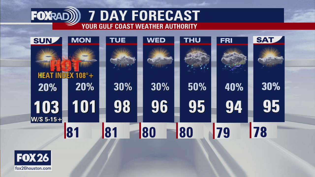
Tuesday morning weather forecast
While Tuesday's forecast is not as hot as the last couple of days, it will still be dangerously hot for Southeast Texas. Heat Advisories remain in place across the Houston area. Temperatures will continue to slowly drop through the week and rain chances should increase.
While Tuesday's forecast is not as hot as the last couple of days, it will still be dangerously hot for Southeast Texas. Heat Advisories remain in place across the Houston area. Temperatures will continue to slowly drop through the week and rain chances should increase.

Monday evening weather forecast
While Tuesday's forecast is not as hot as the last couple of days, it will still be dangerously hot for Southeast Texas. Heat Advisories remain in place across the Houston area. Temperatures will continue to slowly drop through the week and rain chances should increase.
While Tuesday's forecast is not as hot as the last couple of days, it will still be dangerously hot for Southeast Texas. Heat Advisories remain in place across the Houston area. Temperatures will continue to slowly drop through the week and rain chances should increase.

Tropical Weather Forecast - July 11, 2022
The National Hurricane Center is monitoring a broad trough of low pressure in the northern Gulf of Mexico for potential development later this week. It is highly uncertain if this will actually develop into something and where it will go.
The National Hurricane Center is monitoring a broad trough of low pressure in the northern Gulf of Mexico for potential development later this week. It is highly uncertain if this will actually develop into something and where it will go.


July's full 'Buck Moon' will be the brightest Supermoon of the year: How and when to watch
July's full moon is a supermoon, meaning it is closer in its orbit to Earth, making it appear larger and brighter in the sky. The moon will be 222,089 miles away from Earth during its closest approach, about 17,000 miles closer than it is on average, according to NASA.
July's full moon is a supermoon, meaning it is closer in its orbit to Earth, making it appear larger and brighter in the sky. The moon will be 222,089 miles away from Earth during its closest approach, about 17,000 miles closer than it is on average, according to NASA.
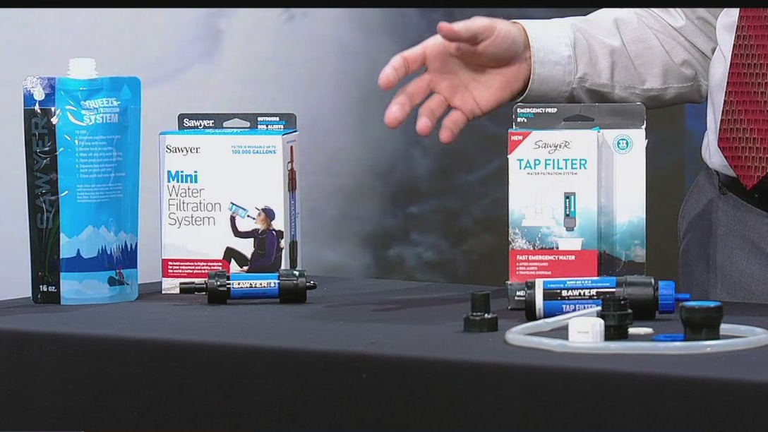

Hurricane Gear Test: Sawyer Tap Filter
Keeping clean, safe water in your hurricane kit can be a challenge. FOX 26 Meteorologist John Dawson tells viewers about the Sawyer water filtration system that removes 99.9999% of bacteria and protozoa.
Keeping clean, safe water in your hurricane kit can be a challenge. FOX 26 Meteorologist John Dawson tells viewers about the Sawyer water filtration system that removes 99.9999% of bacteria and protozoa.
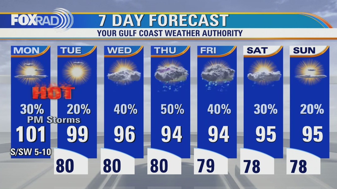

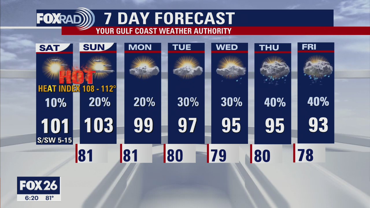
Very hot day Monday with isolated late day storms
Brace yourself for another very hot day with another chance for late-day and evening storms. A heat advisory is in effect for the Houston area along with an excessive heat warning for communities west of Katy and Hempstead. Today's heat index could hit 110, but watch your FOX 26 weather app for some evening storms. Tomorrow looks very hot as well, but high pressure may start to move westward by later this week, so our temperatures could cool by several degrees. There is a slight chance for a small tropical low to form south of New Orleans this week. Its future motion is unclear, but could bring us some rain by Thursday or Friday.
Brace yourself for another very hot day with another chance for late-day and evening storms. A heat advisory is in effect for the Houston area along with an excessive heat warning for communities west of Katy and Hempstead. Today's heat index could hit 110, but watch your FOX 26 weather app for some evening storms. Tomorrow looks very hot as well, but high pressure may start to move westward by later this week, so our temperatures could cool by several degrees. There is a slight chance for a small tropical low to form south of New Orleans this week. Its future motion is unclear, but could bring us some rain by Thursday or Friday.

Sunday night leading into Monday morning weather forecast
Dangerously heat continues for Monday across Southeast Texas. Excessive Heat Warnings and Heat Advisories will be in place for the FOX 26 area. Isolated showers or storms will start entering the forecast with temperatures slowly declining during the week.
Dangerously heat continues for Monday across Southeast Texas. Excessive Heat Warnings and Heat Advisories will be in place for the FOX 26 area. Isolated showers or storms will start entering the forecast with temperatures slowly declining during the week.

Tropical Weather Forecast - July 10, 2022
National Hurricane Center is looking at the Gulf of Mexico at the end of this week.
National Hurricane Center is looking at the Gulf of Mexico at the end of this week.

How common is Houston's dangerous heat, what is driving the triple digits?
Dangerous heat continues as we close out the weekend and heat into the work week. After three 100+ degree days last week, that brings the running tally for the city of Houston up to a total of eight so far this year.
Dangerous heat continues as we close out the weekend and heat into the work week. After three 100+ degree days last week, that brings the running tally for the city of Houston up to a total of eight so far this year.
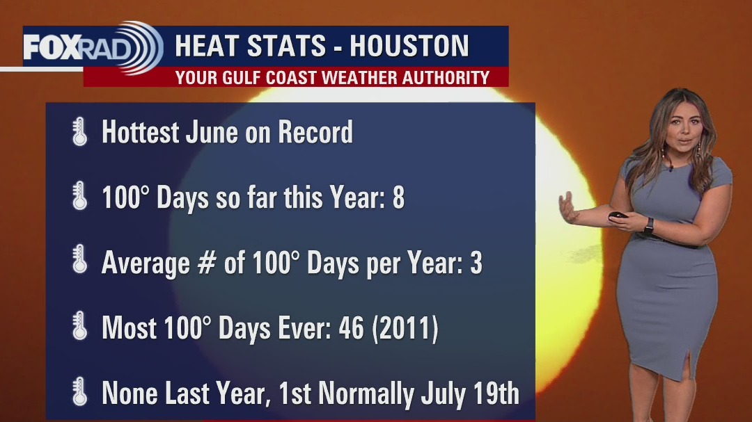

Sunday Morning Forecast with Meteorologist Lena Maria
Dangerous heat both continues, and looks to peak today. Exercise extreme caution if spending time outdoors, especially for sensitive populations. A few lucky ones will see an isolated shower or storm today, and a possible stronger storm or downpour may mix down some gusty winds. While rain chances don't look overly impressive this week for now, possibilities at least exist daily and that looks to drive down our temperatures to a more manageable, and seasonable range.
Dangerous heat both continues, and looks to peak today. Exercise extreme caution if spending time outdoors, especially for sensitive populations. A few lucky ones will see an isolated shower or storm today, and a possible stronger storm or downpour may mix down some gusty winds. While rain chances don't look overly impressive this week for now, possibilities at least exist daily and that looks to drive down our temperatures to a more manageable, and seasonable range.

Saturday night leading into Sunday morning weather forecast
Dangerously hot conditions continue tomorrow. Heat advisories have been extended for the entire area thru Sunday evening. Temperatures will soar to record levels and heat index are expected to exceed 108 tomorrow afternoon. A weak boundary nearby may pop off a few isolated thunderstorms but most locations will stay dry. Stay cool everyone!
Dangerously hot conditions continue tomorrow. Heat advisories have been extended for the entire area thru Sunday evening. Temperatures will soar to record levels and heat index are expected to exceed 108 tomorrow afternoon. A weak boundary nearby may pop off a few isolated thunderstorms but most locations will stay dry. Stay cool everyone!

Tropical Weather Forecast - July 9, 2022
Bonnie's long voyage from the Caribbean has come to an end as the storm has now become post-tropical. Tropical Storm Darby has formed and another area bears watching in the East Pacific. Meanwhile, the Atlantic basin stays quiet with no tropical activity expected in the next 5 days.
Bonnie's long voyage from the Caribbean has come to an end as the storm has now become post-tropical. Tropical Storm Darby has formed and another area bears watching in the East Pacific. Meanwhile, the Atlantic basin stays quiet with no tropical activity expected in the next 5 days.

Saturday weather forecast with Meteorologist Lena Maria Arango
This weekend will likely feature our hottest temperatures so far year to date. Heat Advisories blanket the area for most of Saturday, with Excessive Heat Warnings to our north. Monday still looks hot for many, and potentially even Tuesday but depending on how things begin to shift we can expect a gradual cooldown next week. An increase in clouds, and rain chances will help keep temperatures at bay. In the mean time -- take it easy out there!
This weekend will likely feature our hottest temperatures so far year to date. Heat Advisories blanket the area for most of Saturday, with Excessive Heat Warnings to our north. Monday still looks hot for many, and potentially even Tuesday but depending on how things begin to shift we can expect a gradual cooldown next week. An increase in clouds, and rain chances will help keep temperatures at bay. In the mean time -- take it easy out there!
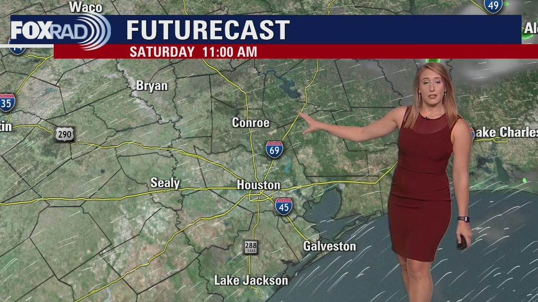

Saturday morning weather forecast
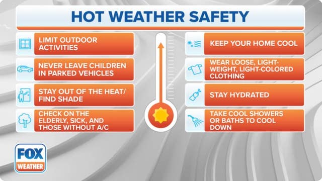
Dangerously hot conditions are setting up for the weekend. Heat advisories have been posted for Saturday with highs closing in on record territory and heat index values approaching 110. Scorching heat continues on Sunday with temperatures again soaring into the triple digits. Make sure you are drinking plenty of water and taking breaks often in the shade and AC.
Dangerously hot conditions are setting up for the weekend. Heat advisories have been posted for Saturday with highs closing in on record territory and heat index values approaching 110. Scorching heat continues on Sunday with temperatures again soaring into the triple digits. Make sure you are drinking plenty of water and taking breaks often in the shade and AC.

Have a chill weekend, avoid the Houston heat with these cooling centers
The City of Houston announced its heat emergency plan would be activated after the National Weather Service announced the heat index will reach 108.
The City of Houston announced its heat emergency plan would be activated after the National Weather Service announced the heat index will reach 108.

Friday evening weather forecast with Meteorologist Adrienne Vonn
Dangerously hot conditions are setting up for the weekend. Heat advisories have been posted for Saturday with highs closing in on record territory and heat index values approaching 110. Scorching heat continues on Sunday with temperatures again soaring into the triple digits. Make sure you are drinking plenty of water and taking breaks often in the shade and AC.
Dangerously hot conditions are setting up for the weekend. Heat advisories have been posted for Saturday with highs closing in on record territory and heat index values approaching 110. Scorching heat continues on Sunday with temperatures again soaring into the triple digits. Make sure you are drinking plenty of water and taking breaks often in the shade and AC.