

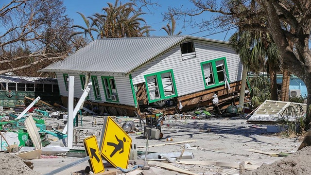

Fort Myers Beach reopens to residents, business owners nearly 2 weeks after Hurricane Ian
Most residents of Fort Myers Beach have been off the island since being evacuated when Hurricane Ian approached the area at the end of September.
Most residents of Fort Myers Beach have been off the island since being evacuated when Hurricane Ian approached the area at the end of September.
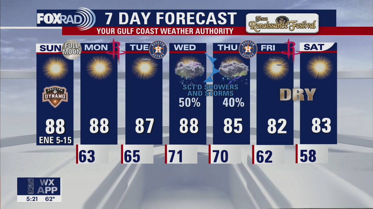

Sunday Morning Forecast with Meteorologist Lena Maria Arango
Quiet, pleasant weather will linger through the start of the week with humidity building by Wednesday. Our next front looks to arrive by Thursday, interacting with remnant moisture from Hurricane Julia providing a much-needed boost in rain chances. Conditions look to improve for game 2 of the ALDS Thursday evening, with dry air draining in to start the weekend. Another front may swing through on Sunday bringing some more showers to close out the weekend.
Quiet, pleasant weather will linger through the start of the week with humidity building by Wednesday. Our next front looks to arrive by Thursday, interacting with remnant moisture from Hurricane Julia providing a much-needed boost in rain chances. Conditions look to improve for game 2 of the ALDS Thursday evening, with dry air draining in to start the weekend. Another front may swing through on Sunday bringing some more showers to close out the weekend.
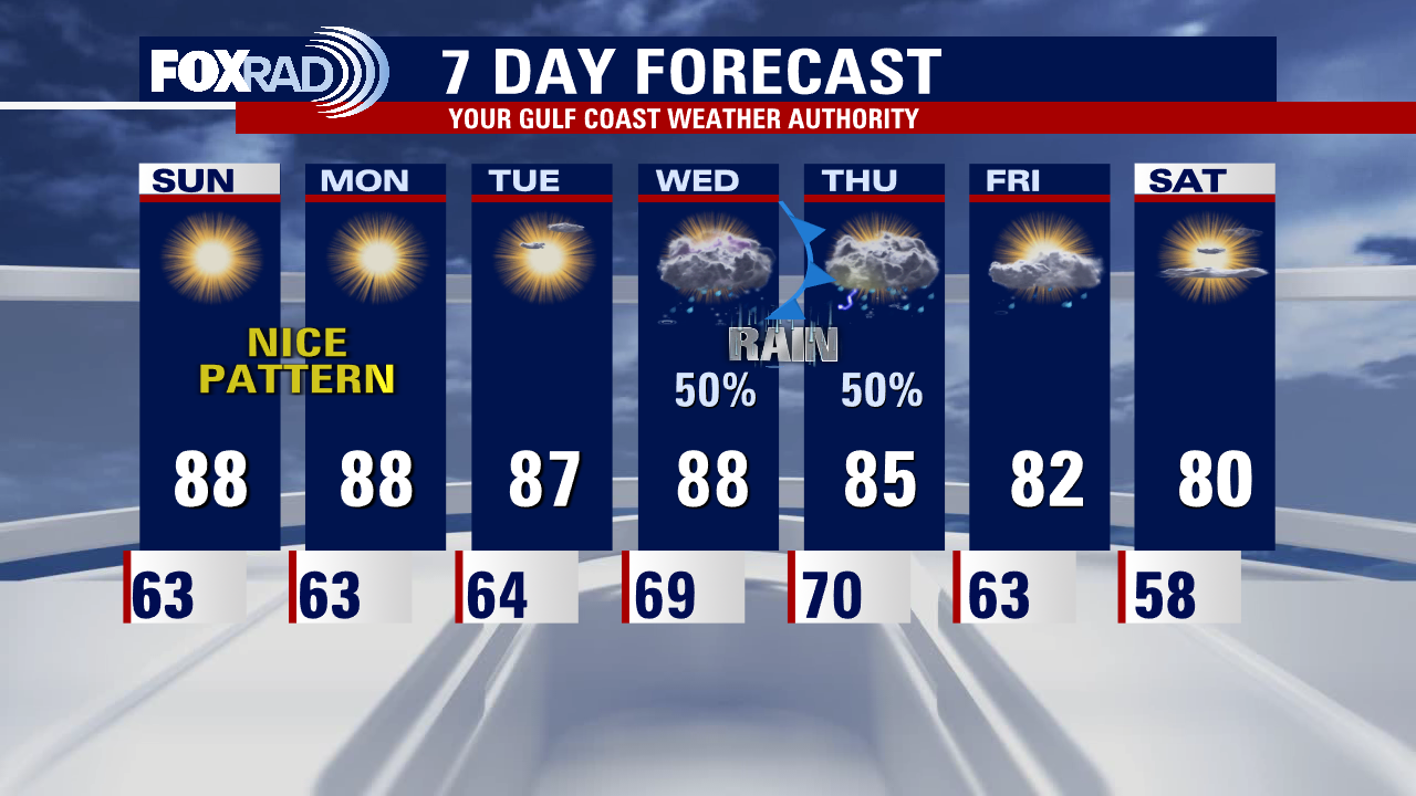

Saturday night leading into Sunday morning weather forecast
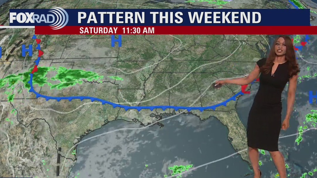
FOX 26 is your Gulf Coast Weather Authority and Chief Meteorologist Mike Iscovitz gives us a look at our weekend forecast.
FOX 26 is your Gulf Coast Weather Authority and Chief Meteorologist Mike Iscovitz gives us a look at our weekend forecast.
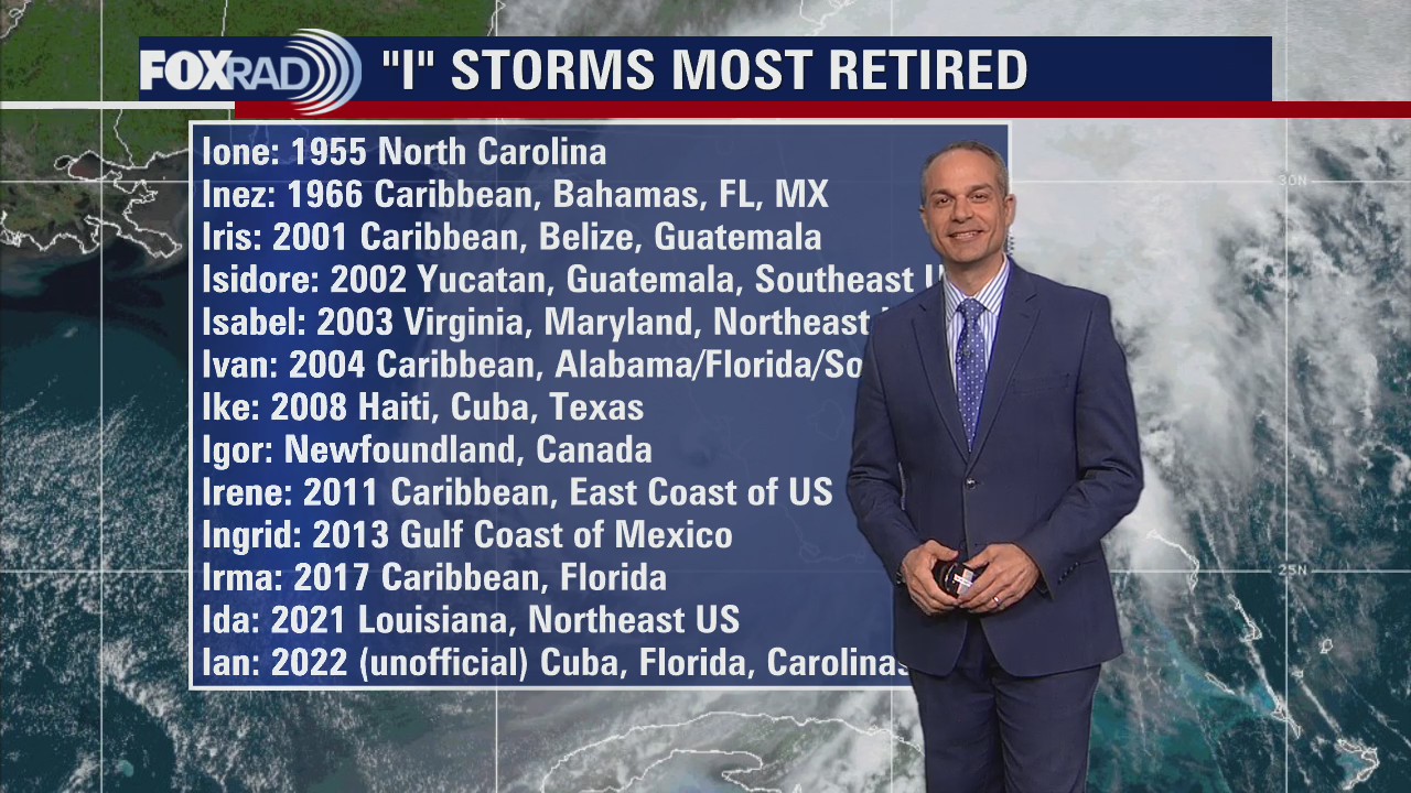

Tropical Weather Forecast - October 8, 2022
FOX 26 Chief Meteorologist Mike Iscovitz gives us a look at the tropics and shares some interesting information on naming the storms.
FOX 26 Chief Meteorologist Mike Iscovitz gives us a look at the tropics and shares some interesting information on naming the storms.

Your Saturday Morning Forecast with Meteorologist Lena Maria
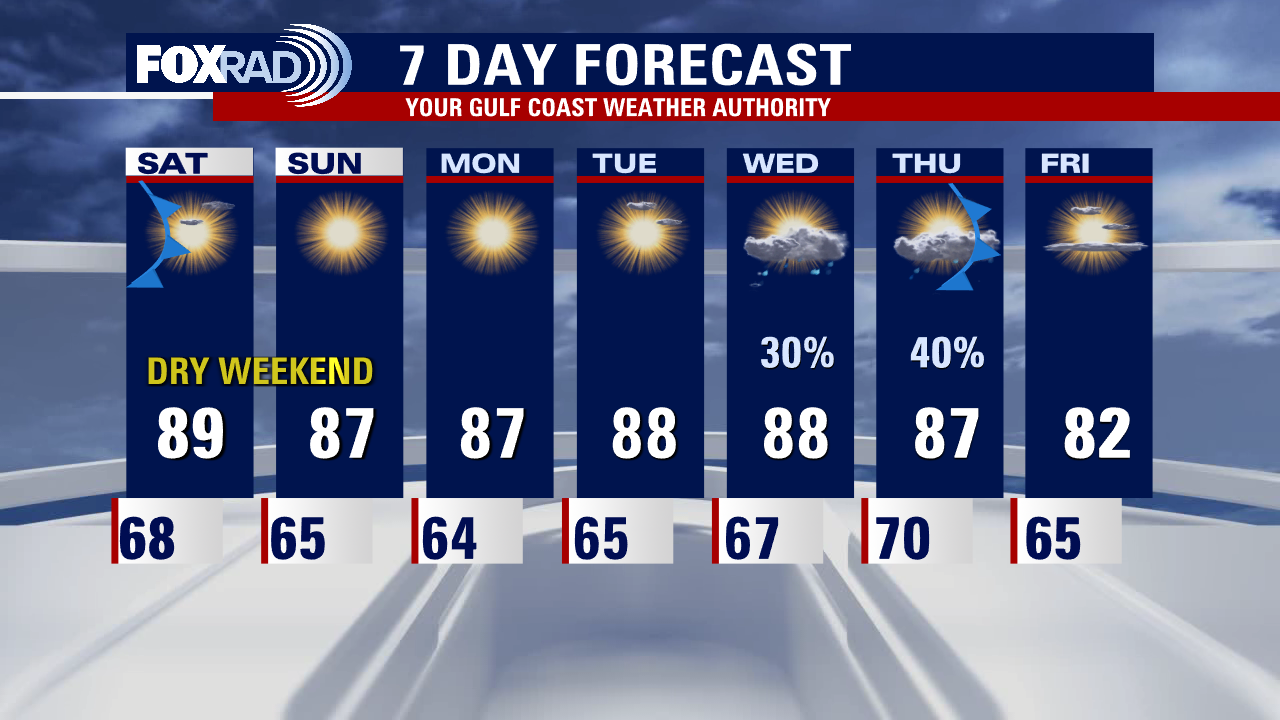
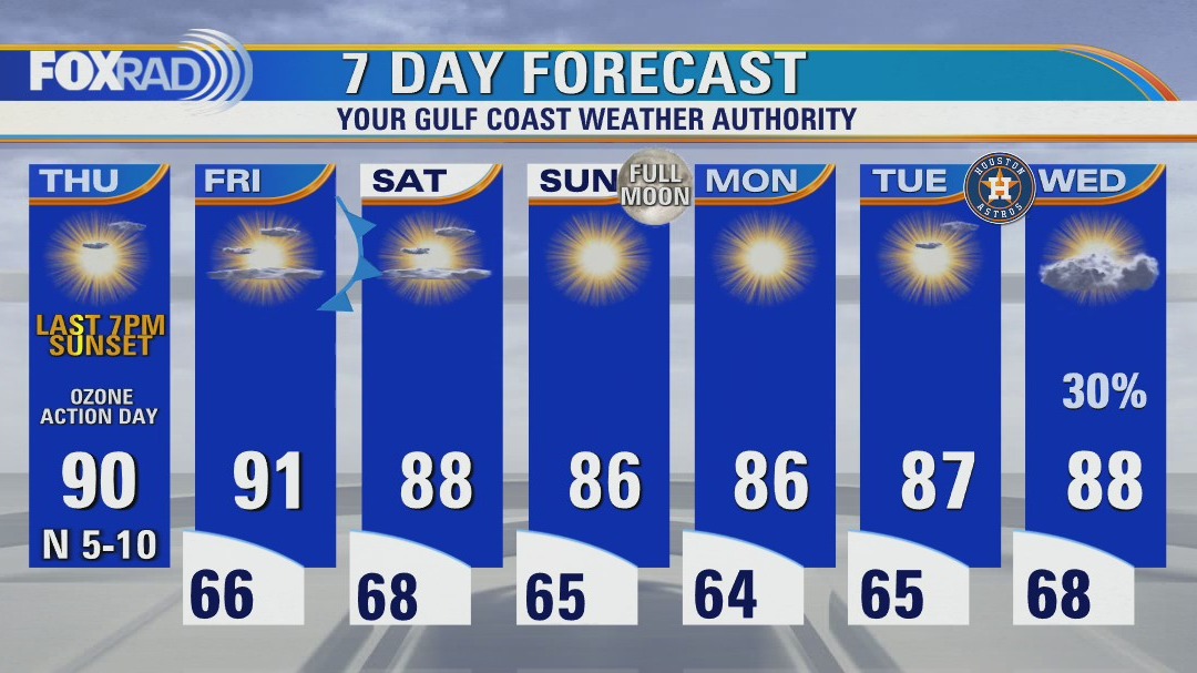
Blissful weather continues for now, which is great news for a busy weekend and week for events and sports in Houston. Middle of next week, a stronger fall front looks to collide with leftover moisture from Julia finally bringing a promising chance for rain. It also looks to bring a much more potent dose of cooler, drier air with lows falling into the 50s for most of us by next Saturday.
Blissful weather continues for now, which is great news for a busy weekend and week for events and sports in Houston. Middle of next week, a stronger fall front looks to collide with leftover moisture from Julia finally bringing a promising chance for rain. It also looks to bring a much more potent dose of cooler, drier air with lows falling into the 50s for most of us by next Saturday.

Saturday morning weather forecast
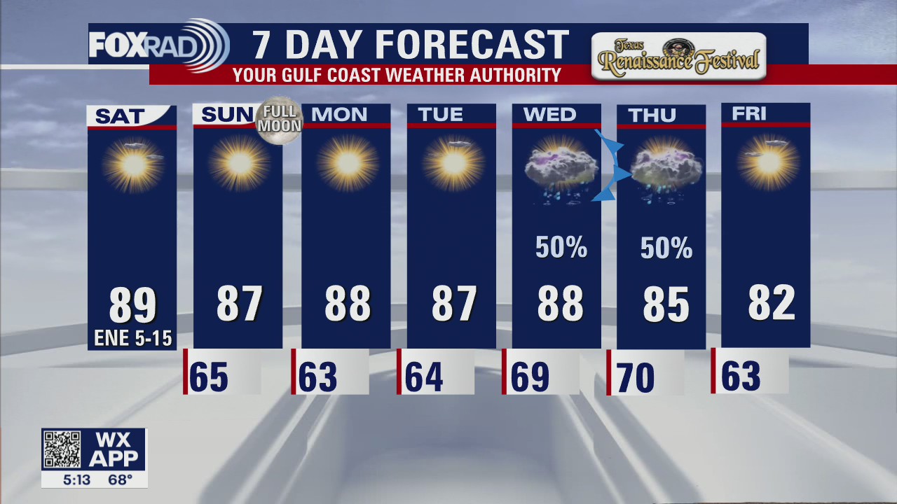
Weak cold front will be dropping into the area tonight through early Saturday. It's bringing thicker clouds and there may be a few sprinkles but no major rain is expected. Clouds should clear for the weekend and it will be breezy Saturday but not quite as hot and dry. Sunday will be bright and dry also. Pattern shifts next week as moisture from what's left of Julia and a stronger cold front will combine to increase our rain and storm chances by Wednesday and Thursday.
Weak cold front will be dropping into the area tonight through early Saturday. It's bringing thicker clouds and there may be a few sprinkles but no major rain is expected. Clouds should clear for the weekend and it will be breezy Saturday but not quite as hot and dry. Sunday will be bright and dry also. Pattern shifts next week as moisture from what's left of Julia and a stronger cold front will combine to increase our rain and storm chances by Wednesday and Thursday.

Friday evening weather forecast with Meteorologist Remeisha Shade
Weak cold front will be dropping into the area tonight through early Saturday. It's bringing thicker clouds and there may be a few sprinkles but no major rain is expected. Clouds should clear for the weekend and it will be breezy Saturday but not quite as hot and dry. Sunday will be bright and dry also. Pattern shifts next week as moisture from what's left of Julia and a stronger cold front will combine to increase our rain and storm chances by Wednesday and Thursday.
Weak cold front will be dropping into the area tonight through early Saturday. It's bringing thicker clouds and there may be a few sprinkles but no major rain is expected. Clouds should clear for the weekend and it will be breezy Saturday but not quite as hot and dry. Sunday will be bright and dry also. Pattern shifts next week as moisture from what's left of Julia and a stronger cold front will combine to increase our rain and storm chances by Wednesday and Thursday.

Tropical Weather Forecast - October 7, 2022
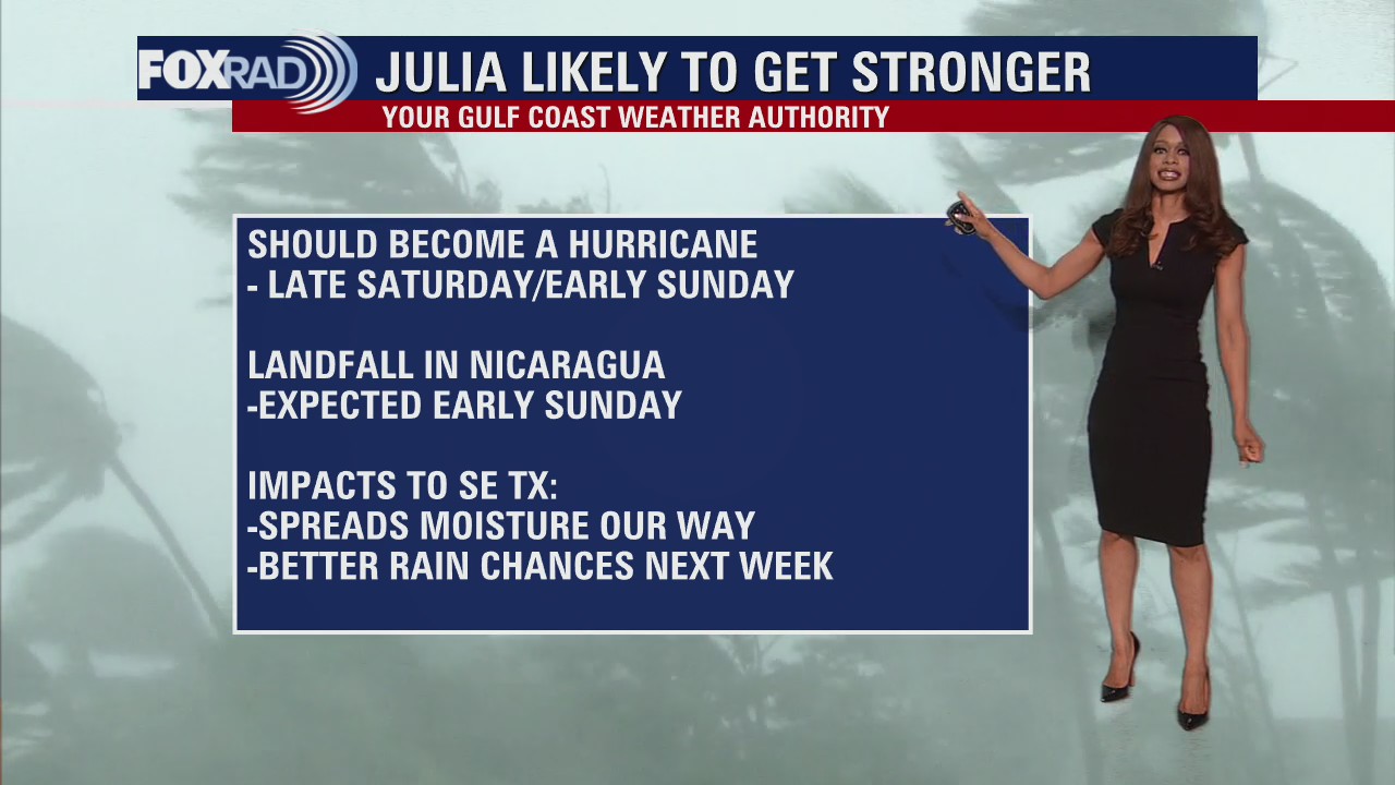
Tropical Update - Tropical Storm Julia is pushing away from Colombia and Venezuela and is still expected to strengthen to a Category 1 hurricane by early Sunday. It is forecast to make landfall on the Nicaragua coast of Central America Sunday morning bringing the threat of flooding and mudslides. Although we won't get any direct impacts from Julia, moisture from the remnants of Julia will likely spread our way by the middle of next week.
Tropical Update - Tropical Storm Julia is pushing away from Colombia and Venezuela and is still expected to strengthen to a Category 1 hurricane by early Sunday. It is forecast to make landfall on the Nicaragua coast of Central America Sunday morning bringing the threat of flooding and mudslides. Although we won't get any direct impacts from Julia, moisture from the remnants of Julia will likely spread our way by the middle of next week.
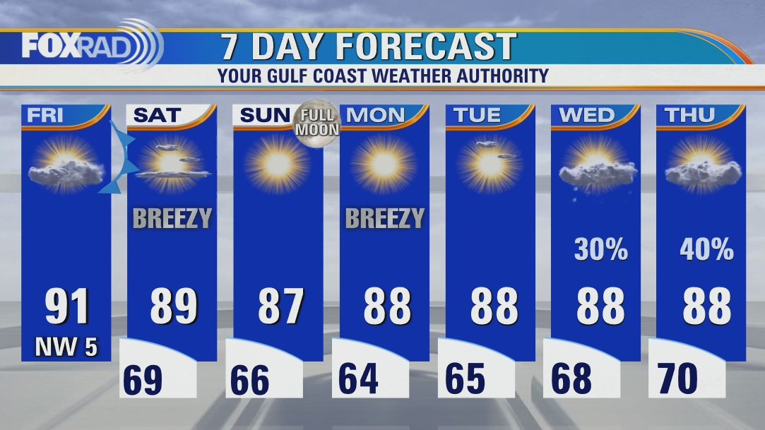

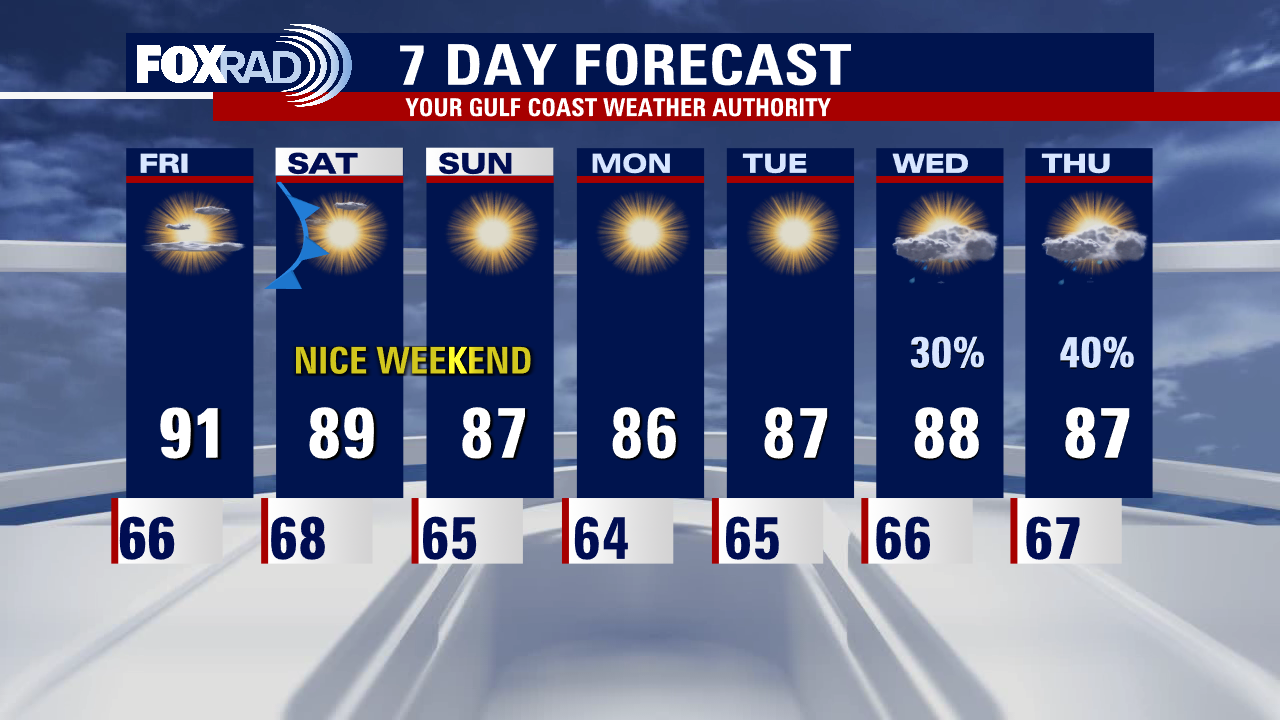
Another warm, dry day Friday with highs in the low 90s
Heading into the long weekend on a warm note, with more cloud cover and another air quality alert for ozone. By tomorrow morning, a weak front will have cleared the coastline and north breezes will quickly scatter out any leftover clouds as drier, cooler air drains in. Sunny, dry weather with near seasonable temperatures will linger until middle of next week, when a combination of another approaching front and leftover moisture from now TD13 will bring us the best rain chances we have seen in a while.
Heading into the long weekend on a warm note, with more cloud cover and another air quality alert for ozone. By tomorrow morning, a weak front will have cleared the coastline and north breezes will quickly scatter out any leftover clouds as drier, cooler air drains in. Sunny, dry weather with near seasonable temperatures will linger until middle of next week, when a combination of another approaching front and leftover moisture from now TD13 will bring us the best rain chances we have seen in a while.

Friday weather forecast
Friday will be another warm, dry day with highs in the low 90s and a bit more cloudiness.
Friday will be another warm, dry day with highs in the low 90s and a bit more cloudiness.
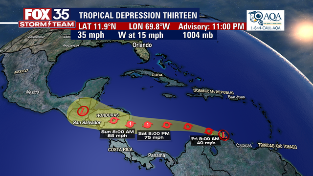

Tropical Depression 13 forms in Caribbean, expected to become Hurricane Julia this weekend
Tropical Depression Thirteen formed in the Atlantic late Thursday evening and is forecast to become our next hurricane.
Tropical Depression Thirteen formed in the Atlantic late Thursday evening and is forecast to become our next hurricane.

Friday morning weather forecast
A few changes are finally showing up in our extended forecast. For the short term, it will be more warm and dry weather that will prevail. A weak cold front will arrive late Friday that will knock temperatures down a few degrees for the weekend. Moisture gradually increases mid-late next week from a tropical system south and an approaching cold front. That means rain chances are increasing by Wednesday and Thursday.
A few changes are finally showing up in our extended forecast. For the short term, it will be more warm and dry weather that will prevail. A weak cold front will arrive late Friday that will knock temperatures down a few degrees for the weekend. Moisture gradually increases mid-late next week from a tropical system south and an approaching cold front. That means rain chances are increasing by Wednesday and Thursday.


Hurricane Ian Aftermath: Power now restored to most of Florida
Across southwest Florida, people continue the painstaking process of combing through what's left of homes and businesses statewide.
Across southwest Florida, people continue the painstaking process of combing through what's left of homes and businesses statewide.

Thursday evening weather forecast with Meteorologist Remeisha Shade
A few changes are finally showing up in our extended forecast. For the short term, it will be more warm and dry weather that will prevail. A weak cold front will arrive late Friday that will knock temperatures down a few degrees for the weekend. Moisture gradually increases mid-late next week from a tropical system south and an approaching cold front. That means rain chances are increasing by Wednesday and Thursday.
A few changes are finally showing up in our extended forecast. For the short term, it will be more warm and dry weather that will prevail. A weak cold front will arrive late Friday that will knock temperatures down a few degrees for the weekend. Moisture gradually increases mid-late next week from a tropical system south and an approaching cold front. That means rain chances are increasing by Wednesday and Thursday.

Tropical Weather Forecast - October 6, 2022
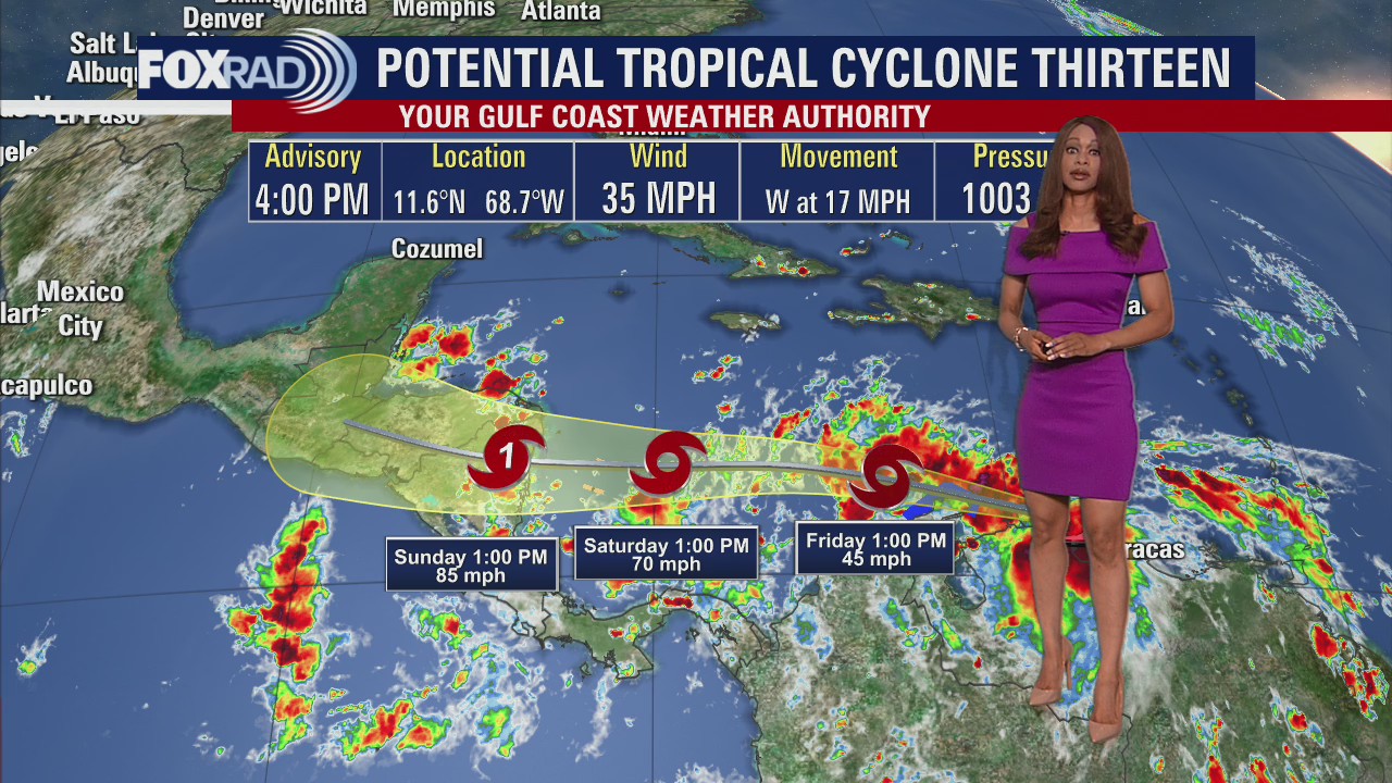
Potential Tropical Cyclone 13 has a 100% chance to form into a tropical cyclone over the next 48 hours and is expected to become a tropical storm by Friday. It has 35 mph winds now but is expected to brush by northern parts of South America over the next few days bringing heavy rain and the threat of flooding. It will then track towards Central America this weekend likely as a Category 1 hurricane. Tropical Depression #12 is still well out in the Atlantic and is expected to weaken to a remnant low over the next day or two.
Potential Tropical Cyclone 13 has a 100% chance to form into a tropical cyclone over the next 48 hours and is expected to become a tropical storm by Friday. It has 35 mph winds now but is expected to brush by northern parts of South America over the next few days bringing heavy rain and the threat of flooding. It will then track towards Central America this weekend likely as a Category 1 hurricane. Tropical Depression #12 is still well out in the Atlantic and is expected to weaken to a remnant low over the next day or two.


Texas ranked 3rd in states most impacted by natural disaster: survey
The devastation of Hurricane Ian and the cost of damages has many wondering what states are most impacted by natural disasters. WalletHub listed Texas third on its list out of all the states.
The devastation of Hurricane Ian and the cost of damages has many wondering what states are most impacted by natural disasters. WalletHub listed Texas third on its list out of all the states.

More sunny and dry conditions Thursday afternoon, rain chances next week
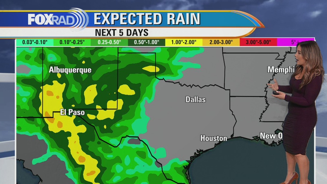
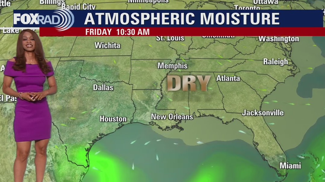
Of the last 30 days, 21 of them have seen air quality alerts issued for ozone and today is no exception. Sunny, dry weather continues for now. Cloud cover may increase some as a weak surface front works its way across the area, but it won't shake up our pattern all that much. It will however put a halt to the increasing temperatures and humidity. As a plus, clear skies will provide great views of our October full moon on Sunday! Our next front, paired with better rain chances looks to arrive middle of next week. No tropical cyclone development is expected in the Pacific in the next 2-5 days. In the Atlantic, Potential Tropical Cyclone 13 (formerly Invest 91-L) has formed and is marching west toward Central America. The Gulf has no tropical concerns at this time.
Of the last 30 days, 21 of them have seen air quality alerts issued for ozone and today is no exception. Sunny, dry weather continues for now. Cloud cover may increase some as a weak surface front works its way across the area, but it won't shake up our pattern all that much. It will however put a halt to the increasing temperatures and humidity. As a plus, clear skies will provide great views of our October full moon on Sunday! Our next front, paired with better rain chances looks to arrive middle of next week. No tropical cyclone development is expected in the Pacific in the next 2-5 days. In the Atlantic, Potential Tropical Cyclone 13 (formerly Invest 91-L) has formed and is marching west toward Central America. The Gulf has no tropical concerns at this time.

Another warm, dry, sunny day with an air quality alert for ozone
Of the last 30 days, 21 of them have seen air quality alerts issued for ozone and today is no exception. Sunny, dry weather continues for now. Cloud cover may increase some as a weak surface front works its way across the area, but it won't shake up our pattern all that much. It will, however put a halt to the increasing temperatures and humidity nudging that down ever so slightly. As a plus, clear skies will provide great views of our October full moon on Sunday! Our next front, paired with better rain chances looks to arrive middle of next week. Paine has dissipated in the tropical Pacific with no further cyclone development expected in the next 2-5 days. In the tropical Atlantic, TD-12 is holding on but barely, and Invest 91-L is marching westward bringing heavy rain, flooding potential, and gusty winds to the ABC islands and eventually Central America. The Gulf has no tropical concerns at this time.
Of the last 30 days, 21 of them have seen air quality alerts issued for ozone and today is no exception. Sunny, dry weather continues for now. Cloud cover may increase some as a weak surface front works its way across the area, but it won't shake up our pattern all that much. It will, however put a halt to the increasing temperatures and humidity nudging that down ever so slightly. As a plus, clear skies will provide great views of our October full moon on Sunday! Our next front, paired with better rain chances looks to arrive middle of next week. Paine has dissipated in the tropical Pacific with no further cyclone development expected in the next 2-5 days. In the tropical Atlantic, TD-12 is holding on but barely, and Invest 91-L is marching westward bringing heavy rain, flooding potential, and gusty winds to the ABC islands and eventually Central America. The Gulf has no tropical concerns at this time.
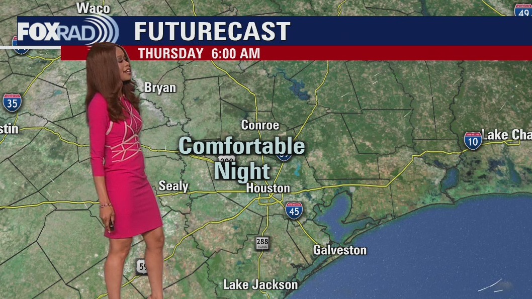

Thursday morning weather forecast
Another stellar weather day is in progress for SE Texas with a good supply of sunshine and warm temperatures in the 80s to near 90. Look for more of the same through the weekend. Weak cool front will bring a little relief from the heat for the weekend but no rain is expected. Moisture builds back in next week with a better chance for a few showers and storms showing up by next Wednesday.
Another stellar weather day is in progress for SE Texas with a good supply of sunshine and warm temperatures in the 80s to near 90. Look for more of the same through the weekend. Weak cool front will bring a little relief from the heat for the weekend but no rain is expected. Moisture builds back in next week with a better chance for a few showers and storms showing up by next Wednesday.


Biden to storm-ravaged Florida: 'We're not going to leave'
President Joe Biden has surveyed the devastation of hurricane-ravaged Florida, promising to marshal the power of the federal government to help rebuild.
President Joe Biden has surveyed the devastation of hurricane-ravaged Florida, promising to marshal the power of the federal government to help rebuild.