

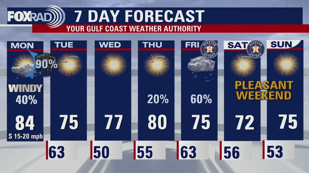

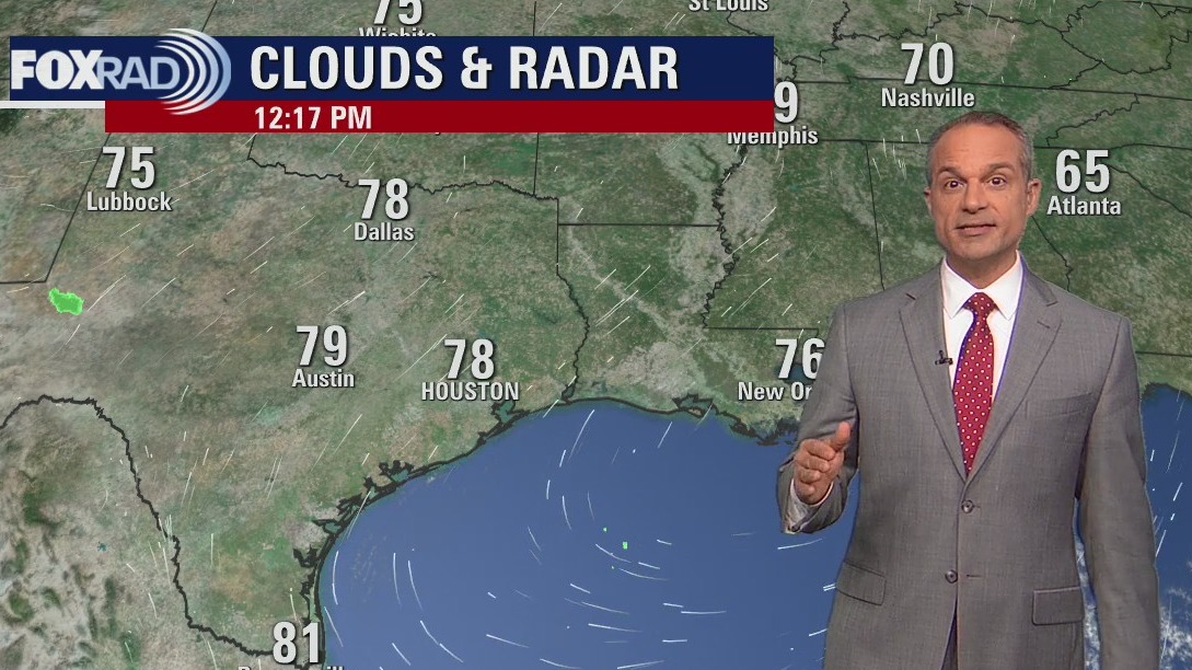
Monday afternoon weather forecast with Meteorologist John Dawson
The world series is coming to Houston and so far, it looks rainy for game 1 and nice for game 2 - the roof will most likely be closed on Friday. In the short term, our main concern is an expected line of thunderstorms overnight tonight between around 10 p.m. and 4 a.m. Severe winds are possible along with brief heavy rain and lightning, but nice weather will follow for Tuesday and Wednesday
The world series is coming to Houston and so far, it looks rainy for game 1 and nice for game 2 - the roof will most likely be closed on Friday. In the short term, our main concern is an expected line of thunderstorms overnight tonight between around 10 p.m. and 4 a.m. Severe winds are possible along with brief heavy rain and lightning, but nice weather will follow for Tuesday and Wednesday


Michigan man dies from ‘flesh-eating’ bacteria after helping in Hurricane Ian recovery
James Hewitt rushed to help his friend in Florida after Hurricane Ian leveled parts of the state, but his fiancée says he was unaware of the dangers of infection.
James Hewitt rushed to help his friend in Florida after Hurricane Ian leveled parts of the state, but his fiancée says he was unaware of the dangers of infection.

Hurricane Gear Test: Dorcy Rechargeable Adventure Lantern
There was a time not that long ago when Meteorologist John Dawson said rechargeable lights don't belong in hurricane kits, because he only wanted to see ones that ran on disposable batteries, but times have changed along with battery technology.
There was a time not that long ago when Meteorologist John Dawson said rechargeable lights don't belong in hurricane kits, because he only wanted to see ones that ran on disposable batteries, but times have changed along with battery technology.
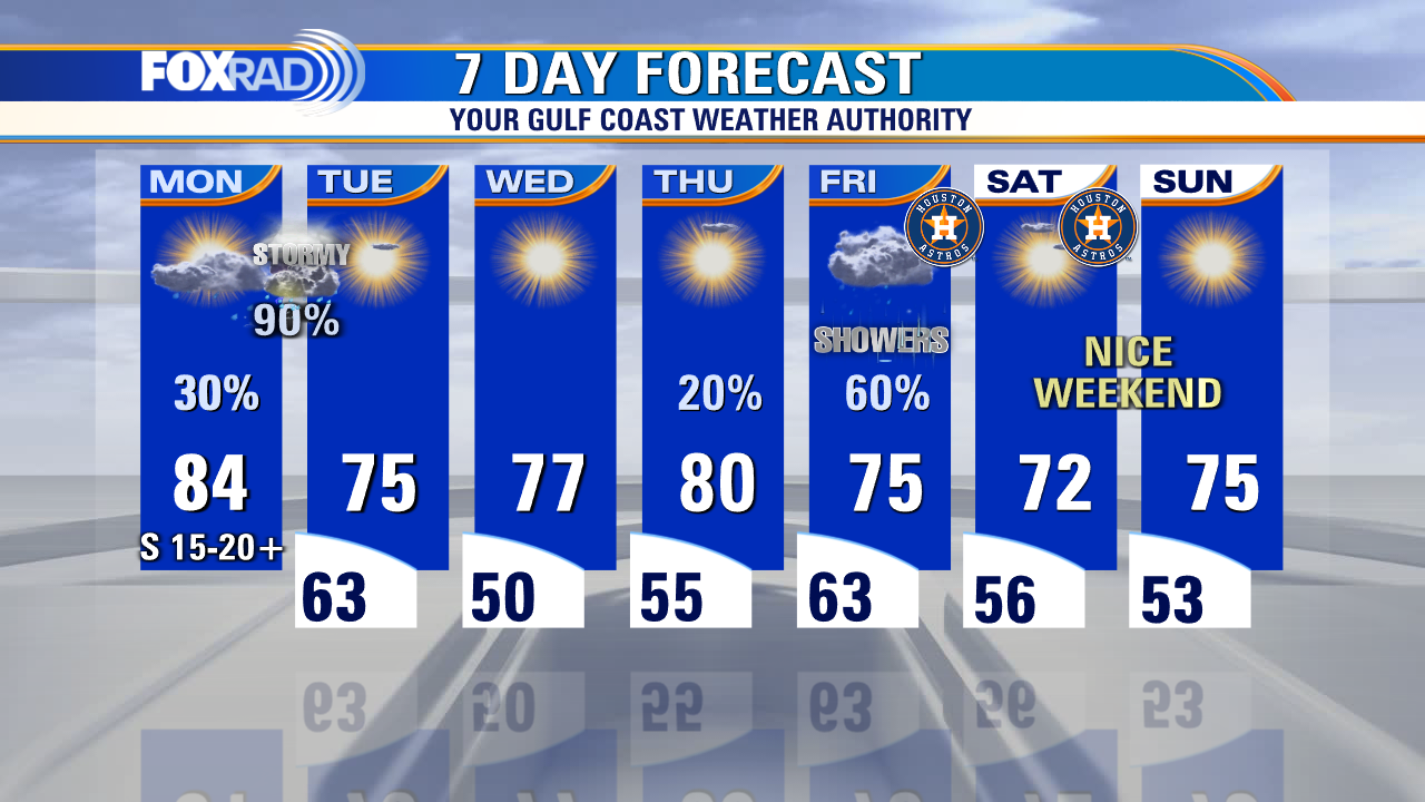

Monday morning weather forecast with Chief Meteorologist Mike Iscovitz
The world series is coming to Houston and so far, it looks rainy for game 1 and nice for game 2 - the roof will most likely be closed on Friday. In the short term, our main concern is an expected line of thunderstorms overnight tonight between around 10pm and 4am. Severe winds are possible along with brief heavy rain and lightning, but nice weather will follow for Tuesday and Wednesday.
The world series is coming to Houston and so far, it looks rainy for game 1 and nice for game 2 - the roof will most likely be closed on Friday. In the short term, our main concern is an expected line of thunderstorms overnight tonight between around 10pm and 4am. Severe winds are possible along with brief heavy rain and lightning, but nice weather will follow for Tuesday and Wednesday.
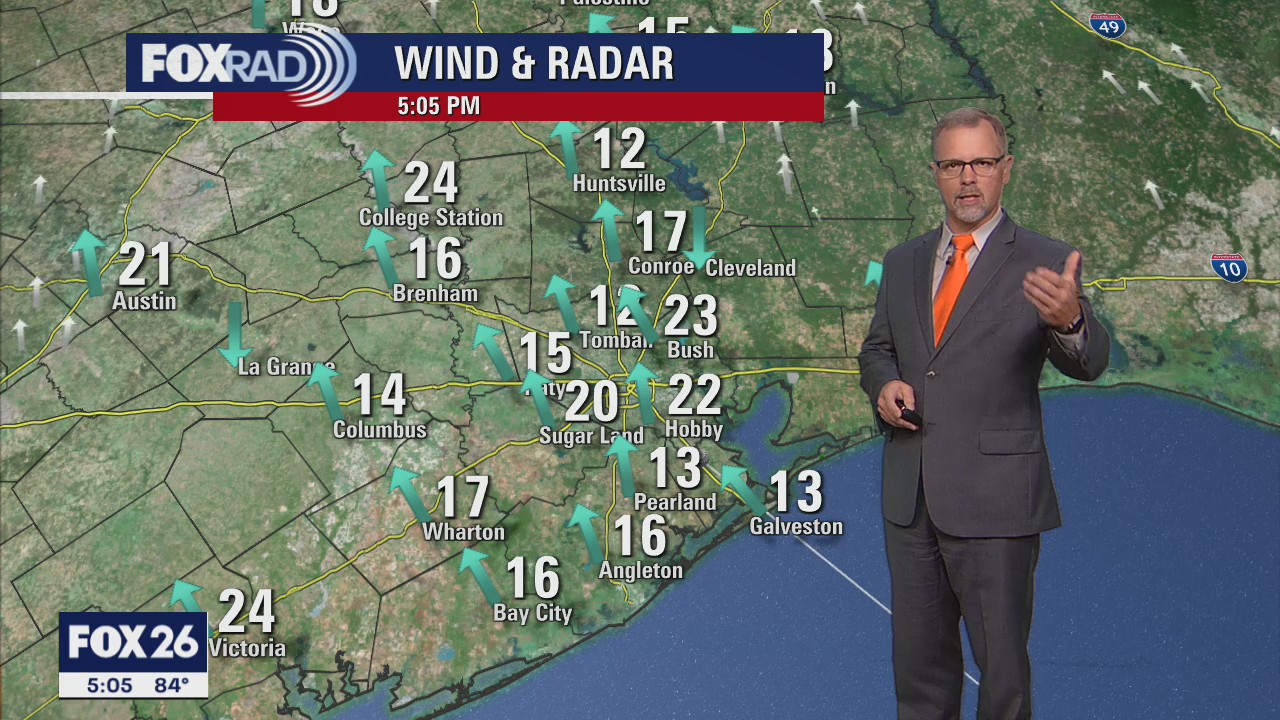

Very breezy, in the 80s this Sunday evening
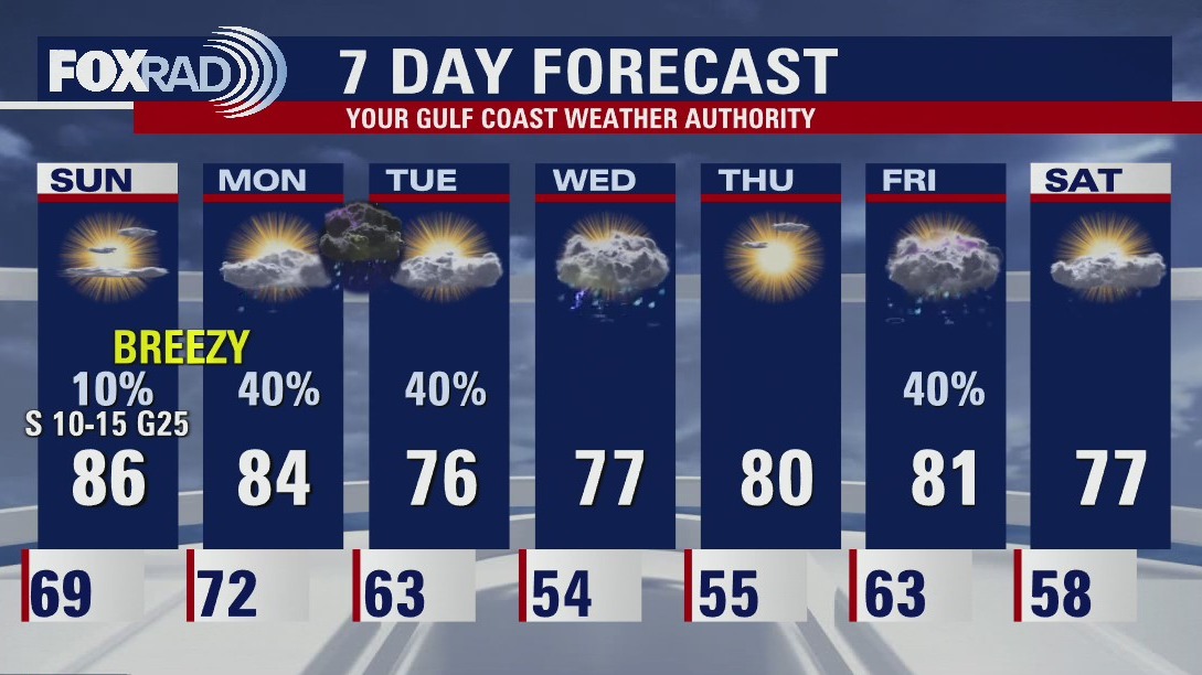
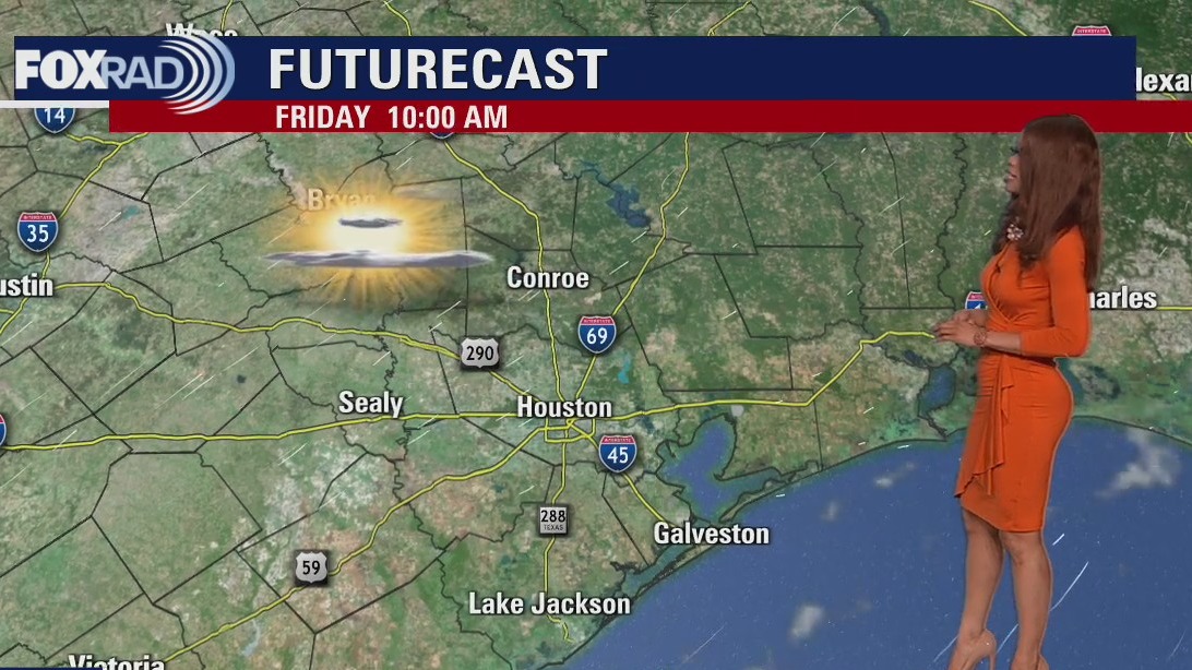
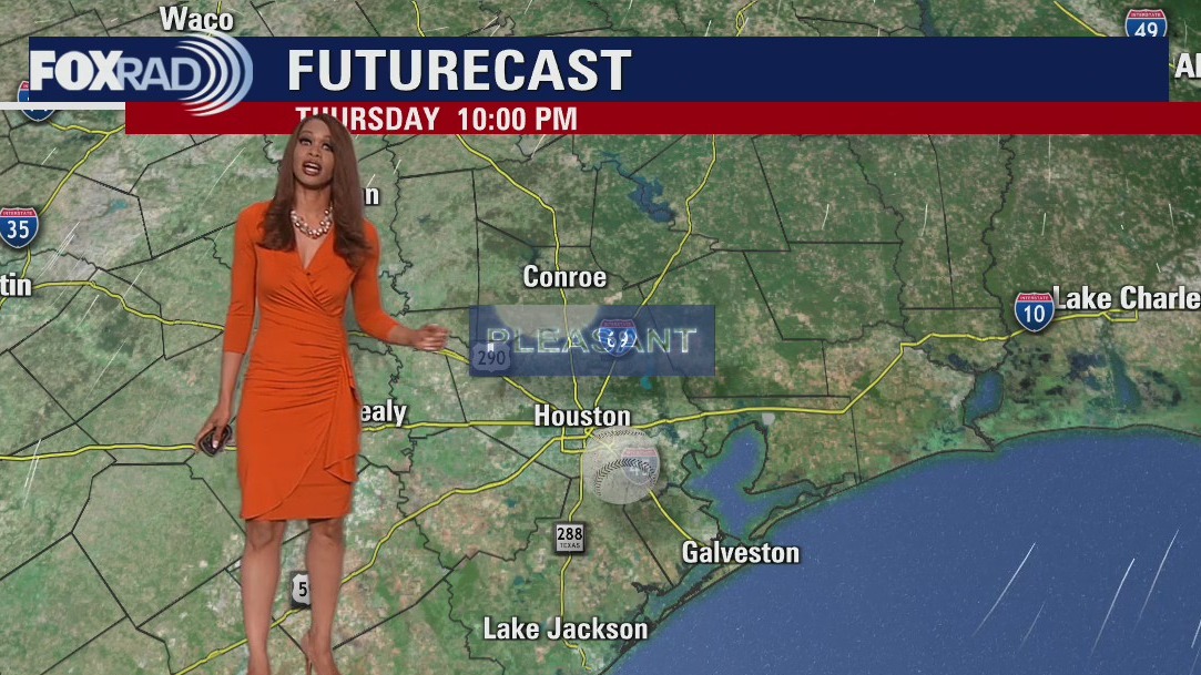
There are a couple of fronts coming to Houston this week. Both will bring some showers/storms and cooler temperatures. The first batch of rain should reach Houston Monday night after midnight. Look for sunny skies and pleasant afternoons Tuesday and Wednesday. The second front will arrive in Southeast Texas at the end of the week. Currently, it looks like it should leave us with a great weekend for outdoor events.
There are a couple of fronts coming to Houston this week. Both will bring some showers/storms and cooler temperatures. The first batch of rain should reach Houston Monday night after midnight. Look for sunny skies and pleasant afternoons Tuesday and Wednesday. The second front will arrive in Southeast Texas at the end of the week. Currently, it looks like it should leave us with a great weekend for outdoor events.

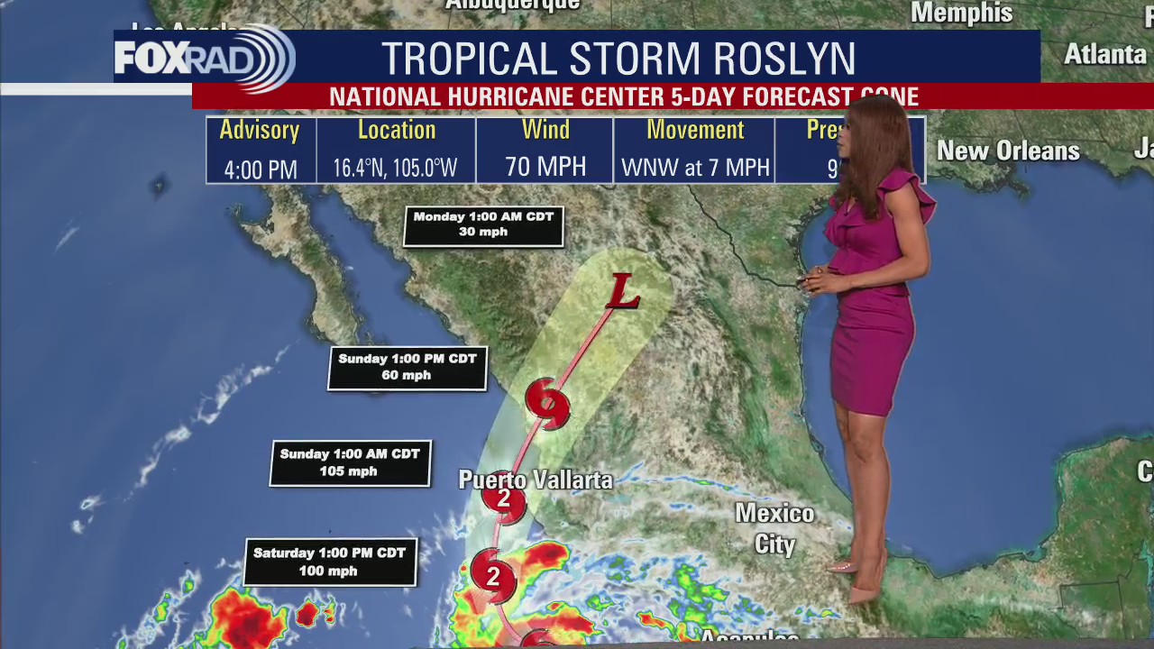
Tropical Weather Forecast - October 23, 2022
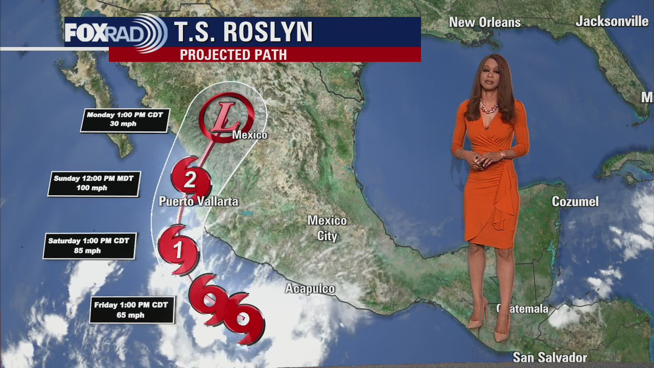
Roslyn made landfall early Sunday morning as a major hurricane with sustained winds of 120mph. Roslyn will fall apart quickly over Mexico but is expected to push moisture toward southeast Texas.
Roslyn made landfall early Sunday morning as a major hurricane with sustained winds of 120mph. Roslyn will fall apart quickly over Mexico but is expected to push moisture toward southeast Texas.

Sunday Morning Forecast with Meteorologist Lena Maria Arango
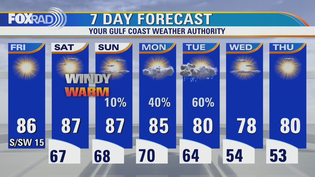
Another warm and windy day is on tap to close out the weekend, with a very humid start to the work week in the low 70s. Most of the day Monday will be mostly cloudy and showery in nature, with the bulk of the precip holding off until the overnight hours. It could get briefly loud, though pre-dawn as a potent line of storms pushes through. The Storm Prediction Center currently has our area flagged at a 2 on the 1-5 scale for strong to severe weather, that would mainly include gusty winds, heavy rain, and frequent thunder and lightning. The cool-down behind that is mild, and doesn't last long with another front bringing the return of rain chances toward the end of the week.
Another warm and windy day is on tap to close out the weekend, with a very humid start to the work week in the low 70s. Most of the day Monday will be mostly cloudy and showery in nature, with the bulk of the precip holding off until the overnight hours. It could get briefly loud, though pre-dawn as a potent line of storms pushes through. The Storm Prediction Center currently has our area flagged at a 2 on the 1-5 scale for strong to severe weather, that would mainly include gusty winds, heavy rain, and frequent thunder and lightning. The cool-down behind that is mild, and doesn't last long with another front bringing the return of rain chances toward the end of the week.

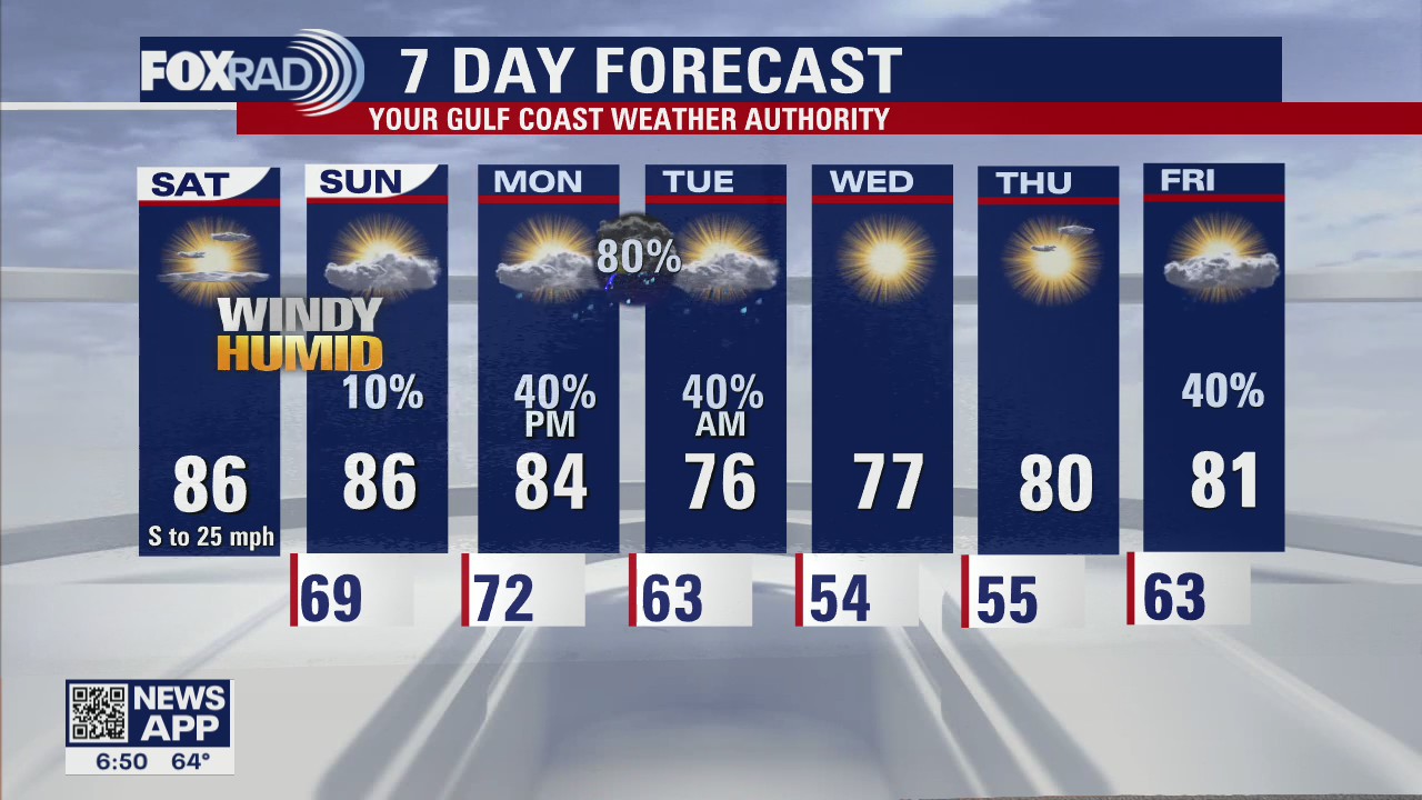
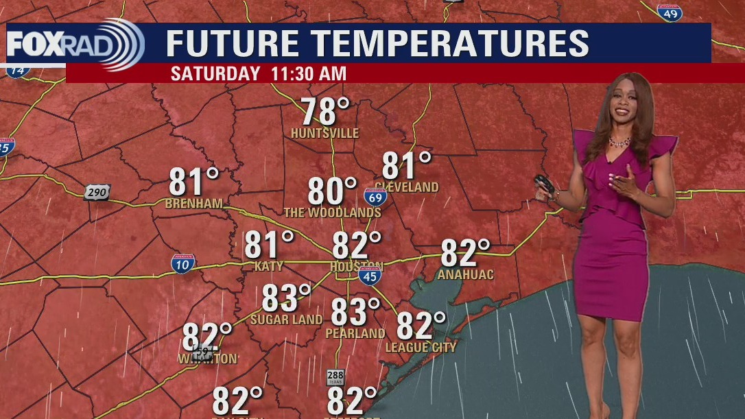
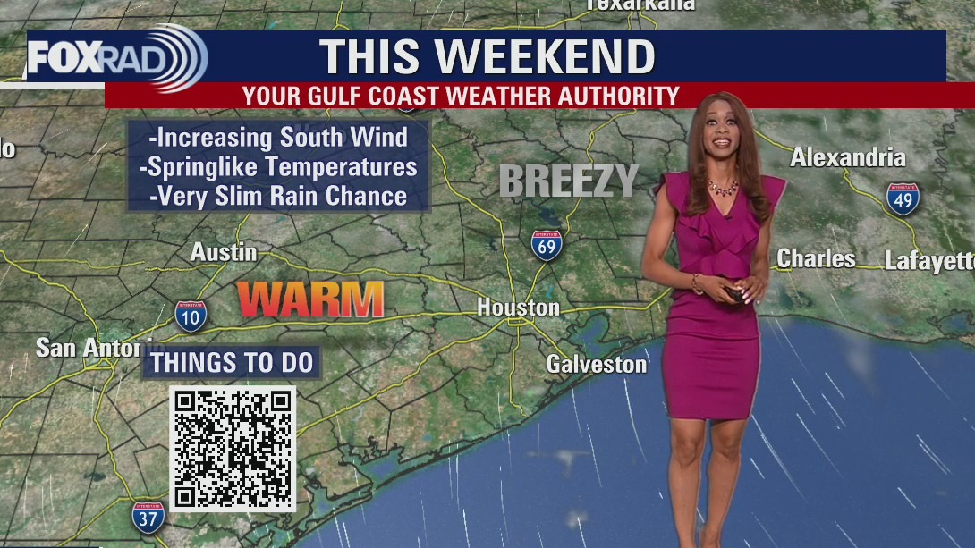
Warm and windy Saturday afternoon in the 80s
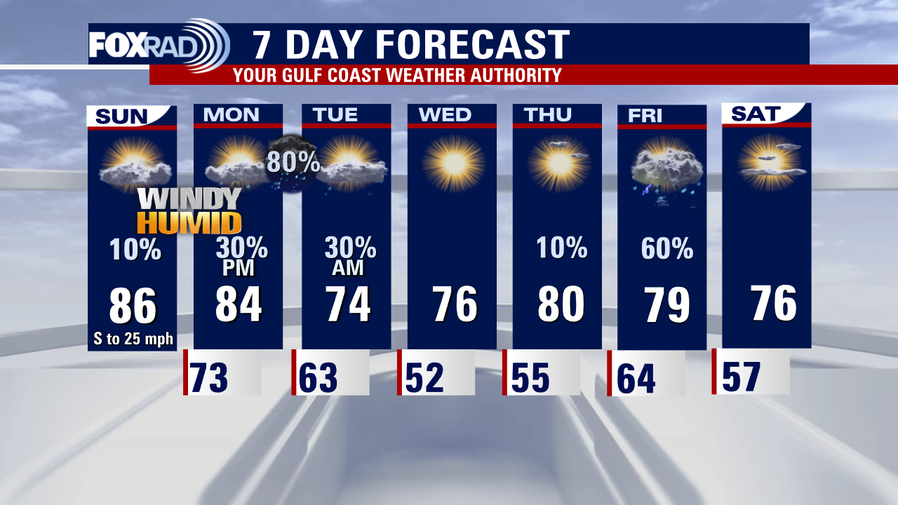
Warm and windy weather will persist for the rest of the weekend across SE Texas with mainly dry weather expected. There's just a 10% chance of a shower Sunday PM. Rain chances increase Monday and Tuesday with a cold front moving through and remnants of Roslyn heading our way. Best shot for rain will be Monday night with an 80% chance. Another round of rain returns late in the week with another front.
Warm and windy weather will persist for the rest of the weekend across SE Texas with mainly dry weather expected. There's just a 10% chance of a shower Sunday PM. Rain chances increase Monday and Tuesday with a cold front moving through and remnants of Roslyn heading our way. Best shot for rain will be Monday night with an 80% chance. Another round of rain returns late in the week with another front.

Tropical Weather Forecast - October 22, 2022
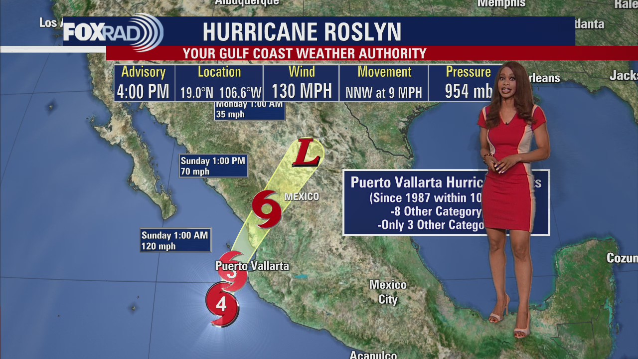
A disorganized tropical wave in the central Atlantic has only a 10-20% shot for development as it moves WNW. On the other hand in the eastern Pacific, Hurricane Roslyn has grown to a dangerous Category 4 hurricane with 130 mph winds. It is expected to make landfall in west-central Mexico early Sunday bringing a flood threat, storm surge, and damaging winds.
A disorganized tropical wave in the central Atlantic has only a 10-20% shot for development as it moves WNW. On the other hand in the eastern Pacific, Hurricane Roslyn has grown to a dangerous Category 4 hurricane with 130 mph winds. It is expected to make landfall in west-central Mexico early Sunday bringing a flood threat, storm surge, and damaging winds.

Saturday Morning Forecast with Meteorologist Lena Maria Arango
Hold onto your cowboy hats, it's gonna be a windy weekend! Humidity will be on the rise ahead of our next frontal system, with overnight lows once again exceeding 70. A much-needed dose of beneficial rainfall arrives overnight Monday into Tuesday. Behind that, we'll get a couple of quiet and slightly cooler days. This front does not look to provide as much of a drastic drop in temperatures as the last one. Humidity quickly builds back in, and rain chances return on Friday.
Hold onto your cowboy hats, it's gonna be a windy weekend! Humidity will be on the rise ahead of our next frontal system, with overnight lows once again exceeding 70. A much-needed dose of beneficial rainfall arrives overnight Monday into Tuesday. Behind that, we'll get a couple of quiet and slightly cooler days. This front does not look to provide as much of a drastic drop in temperatures as the last one. Humidity quickly builds back in, and rain chances return on Friday.

Saturday morning weather forecast
Few changes are in store for Houston weather over the weekend and next week. It will get even warmer with increasing humidity and wind. In fact, winds could gust to near 25 mph this weekend. There's a slim shot for a shower Sunday with better rain and storm chances with a cold front Monday and Tuesday. Also, the remnants of Roslyn early next week could contribute to more moisture over SE Texas and better rain chances.
Few changes are in store for Houston weather over the weekend and next week. It will get even warmer with increasing humidity and wind. In fact, winds could gust to near 25 mph this weekend. There's a slim shot for a shower Sunday with better rain and storm chances with a cold front Monday and Tuesday. Also, the remnants of Roslyn early next week could contribute to more moisture over SE Texas and better rain chances.


Did wind really keep the Yankees from winning Game 2 against the Astros?
Aaron Judge hit a fly ball deep into right field, looking perhaps like the Yankees had just taken the lead!
Aaron Judge hit a fly ball deep into right field, looking perhaps like the Yankees had just taken the lead!

Low 80s, some winds this Friday evening with slim rain chances
Few changes are in store for Houston weather over the weekend and next week. It will get even warmer with increasing humidity and wind. In fact winds could gust to near 25 mph this weekend. There's a slim shot for a shower Sunday with better rain and storm chances with a cold front Monday and Tuesday. Also the remnants of Roslyn early next week could contribute to more moisture over SE Texas and better rain chances.
Few changes are in store for Houston weather over the weekend and next week. It will get even warmer with increasing humidity and wind. In fact winds could gust to near 25 mph this weekend. There's a slim shot for a shower Sunday with better rain and storm chances with a cold front Monday and Tuesday. Also the remnants of Roslyn early next week could contribute to more moisture over SE Texas and better rain chances.

Tropical Weather Forecast - October 21, 2022
Tropical Storm Roslyn has now strengthened to almost hurricane status in the eastern Pacific with winds of 70 mph. It is expected to become a Category 2 hurricane over the weekend before making landfall early Sunday along the west central Mexico coast. It will bring a flood threat, dangerous storm surge and damaging winds. A weak tropical wave in the far east Atlantic has a low 10-20% chance of development over the next 2-5 days.
Tropical Storm Roslyn has now strengthened to almost hurricane status in the eastern Pacific with winds of 70 mph. It is expected to become a Category 2 hurricane over the weekend before making landfall early Sunday along the west central Mexico coast. It will bring a flood threat, dangerous storm surge and damaging winds. A weak tropical wave in the far east Atlantic has a low 10-20% chance of development over the next 2-5 days.

Expect a warm and breezy Friday afternoon in the 80s
A warming trend along with increasing winds are on the way for today and this weekend. Expect highs in the mid-80s today with mid-to-upper 80s this weekend. I also think we'll have windy weather on Saturday and Sunday which will slowly increase our humidity. A weak cold front early next week should bring a round of showers late Monday into Tuesday.
A warming trend along with increasing winds are on the way for today and this weekend. Expect highs in the mid-80s today with mid-to-upper 80s this weekend. I also think we'll have windy weather on Saturday and Sunday which will slowly increase our humidity. A weak cold front early next week should bring a round of showers late Monday into Tuesday.

Not as chilly Friday morning, then sunny and breezy
A warming trend along with increasing winds are on the way for today and this weekend. Expect highs in the mid 80s today with mid to upper 80s this weekend. I also think we'll have windy weather for Saturday and Sunday which will slowly increase our humidity. A weak cold front early next week should bring a round of showers late Monday into Tuesday.
A warming trend along with increasing winds are on the way for today and this weekend. Expect highs in the mid 80s today with mid to upper 80s this weekend. I also think we'll have windy weather for Saturday and Sunday which will slowly increase our humidity. A weak cold front early next week should bring a round of showers late Monday into Tuesday.

Friday morning weather forecast
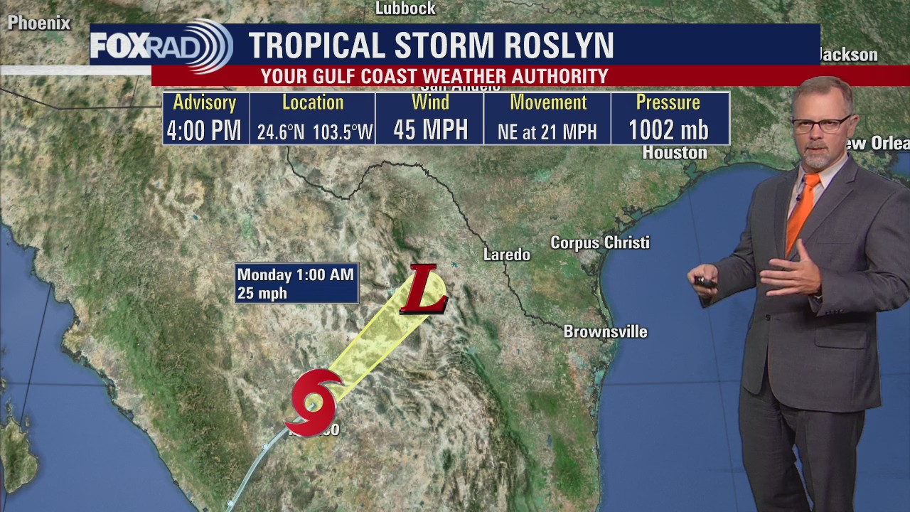
Weather looks great for Astros game tonight with clear skies and pleasant temps dropping from the 70s around the 6:37 first pitch time to the 60s for the majority of the game. Wind will be out of the SW around 5-15 mph. Warmer and more humid weather returns just in time for the weekend with temperatures not far from 90 Saturday and Sunday. Next cold front arrives early next week bringing another round of showers and storms. Tropical Storm Roslyn has formed in the eastern Pacific with 45 mph winds and is expected to become a hurricane this weekend threatening parts of Mexico.
Weather looks great for Astros game tonight with clear skies and pleasant temps dropping from the 70s around the 6:37 first pitch time to the 60s for the majority of the game. Wind will be out of the SW around 5-15 mph. Warmer and more humid weather returns just in time for the weekend with temperatures not far from 90 Saturday and Sunday. Next cold front arrives early next week bringing another round of showers and storms. Tropical Storm Roslyn has formed in the eastern Pacific with 45 mph winds and is expected to become a hurricane this weekend threatening parts of Mexico.

Thursday evening weather forecast
Weather looks great for Astros game tonight with clear skies and pleasant temps dropping from the 70s around the 6:37 first pitch time to the 60s for the majority of the game. Wind will be out of the SW around 5-15 mph. Warmer and more humid weather returns just in time for the weekend with temperatures not far from 90 Saturday and Sunday. Next cold front arrives early next week bringing another round of showers and storms. Tropical Storm Roslyn has formed in the eastern Pacific with 45 mph winds and is expected to become a hurricane this weekend threatening parts of Mexico.
Weather looks great for Astros game tonight with clear skies and pleasant temps dropping from the 70s around the 6:37 first pitch time to the 60s for the majority of the game. Wind will be out of the SW around 5-15 mph. Warmer and more humid weather returns just in time for the weekend with temperatures not far from 90 Saturday and Sunday. Next cold front arrives early next week bringing another round of showers and storms. Tropical Storm Roslyn has formed in the eastern Pacific with 45 mph winds and is expected to become a hurricane this weekend threatening parts of Mexico.

Tropical Weather Forecast - October 20, 2022
All is quiet in the Atlantic with no tropical activity expected over the next two days. However, things are more active in the eastern Pacific with a new Tropical Storm named Roslyn. Roslyn is expected to strengthen to a hurricane by Saturday and make landfall by Sunday along the west central coast of Mexico bringing strong winds and a flood threat.
All is quiet in the Atlantic with no tropical activity expected over the next two days. However, things are more active in the eastern Pacific with a new Tropical Storm named Roslyn. Roslyn is expected to strengthen to a hurricane by Saturday and make landfall by Sunday along the west central coast of Mexico bringing strong winds and a flood threat.


Texas drought might get worse, NOAA winter season outlook predicts
The NOAA Climate Prediction Center released its winter outlook for the country and it looks like our drought might not get better,
The NOAA Climate Prediction Center released its winter outlook for the country and it looks like our drought might not get better,