


Tropical Weather Forecast - October 21, 2023
Two hurricanes to discuss. One in the Atlantic and one in the Pacific. And the National Hurricane Center is also watching another area in the Southwest Caribbean for possible tropical development.
Two hurricanes to discuss. One in the Atlantic and one in the Pacific. And the National Hurricane Center is also watching another area in the Southwest Caribbean for possible tropical development.


Hurricane Norma makes landfall near Mexico's Cabo San Lucas as a Category 1
The once Category 4 hurricane weakened substantially before landfall which helped spare communities around Cabo San Lucas from more extensive damage.
The once Category 4 hurricane weakened substantially before landfall which helped spare communities around Cabo San Lucas from more extensive damage.

Home heating prices are down a little: Here's how much you'll spend this winter
Overall winter heating prices are expected to be flat or a little cheaper than last year, but it depends on where you live and what you use to heat your home.
Overall winter heating prices are expected to be flat or a little cheaper than last year, but it depends on where you live and what you use to heat your home.

Fox 26 Saturday morning weather forecast
Record warm temperatures are possible again today following highs in the low 90s on Friday. Look for more hot weather today with cloudier, warm conditions on Sunday. Rain looks likely on Monday with an unsettled, humid pattern for most of next week.
Record warm temperatures are possible again today following highs in the low 90s on Friday. Look for more hot weather today with cloudier, warm conditions on Sunday. Rain looks likely on Monday with an unsettled, humid pattern for most of next week.

FOX 26 Friday night weather forecast
Near record heat has inundated SE Texas today with temperatures likely climbing to the low 90s again Saturday afternoon! Galveston did set a new record high of 89 degrees today which beats the previous record high of 87 set back in 2019. Plan on a toasty October weekend with highs near 90 through Sunday afternoon with plenty of sun and no rain expected. Weather pattern will start to shift early next week with some tropical moisture from the eastern Pacific moving back into the state. Most of this will remain to our west but spotty rain showers are possible Monday and Tuesday. Rain and storm chances increase closer to the end of next week as a cold front pushes into the area. Temperatures will also start to feel more like late October towards the end of next week. For now, enjoy summer in October this weekend and lets go Astros!
Near record heat has inundated SE Texas today with temperatures likely climbing to the low 90s again Saturday afternoon! Galveston did set a new record high of 89 degrees today which beats the previous record high of 87 set back in 2019. Plan on a toasty October weekend with highs near 90 through Sunday afternoon with plenty of sun and no rain expected. Weather pattern will start to shift early next week with some tropical moisture from the eastern Pacific moving back into the state. Most of this will remain to our west but spotty rain showers are possible Monday and Tuesday. Rain and storm chances increase closer to the end of next week as a cold front pushes into the area. Temperatures will also start to feel more like late October towards the end of next week. For now, enjoy summer in October this weekend and lets go Astros!

FOX 26 Friday evening weather forecast
Near record heat has inundated SE Texas today with temperatures likely climbing to the low 90s again Saturday afternoon! Galveston did set a new record high of 89 degrees today which beats the previous record high of 87 set back in 2019. Plan on a toasty October weekend with highs near 90 through Sunday afternoon with plenty of sun and no rain expected. Weather pattern will start to shift early next week with some tropical moisture from the eastern Pacific moving back into the state. Most of this will remain to our west but spotty rain showers are possible Monday and Tuesday. Rain and storm chances increase closer to the end of next week as a cold front pushes into the area. Temperatures will also start to feel more like late October towards the end of next week. For now, enjoy summer in October this weekend and lets go Astros!
Near record heat has inundated SE Texas today with temperatures likely climbing to the low 90s again Saturday afternoon! Galveston did set a new record high of 89 degrees today which beats the previous record high of 87 set back in 2019. Plan on a toasty October weekend with highs near 90 through Sunday afternoon with plenty of sun and no rain expected. Weather pattern will start to shift early next week with some tropical moisture from the eastern Pacific moving back into the state. Most of this will remain to our west but spotty rain showers are possible Monday and Tuesday. Rain and storm chances increase closer to the end of next week as a cold front pushes into the area. Temperatures will also start to feel more like late October towards the end of next week. For now, enjoy summer in October this weekend and lets go Astros!

Tropical Weather Forecast - October 20, 2023
Tropics remain active with two hurricanes that we are currently tracking! There's Hurricane Tammy in the Atlantic and Hurricane Norma in the eastern Pacific. Tammy is expected to hit parts of the Lesser Antilles today and tomorrow before turning north. Damaging winds, large swells and several inches of rain will be possible that could lead to flooding. Guadeloupe remains under a hurricane warning with a tropical storm warning for Dominica. Tammy should stay away from the United States as it turns north then northeast early next week. Hurricane Norma is a major hurricane just west of Mexico. It is moving north and should hit the southern tip of the Baja Peninsula this weekend. Some of the moisture from Norma will spill into Texas early next week. Another broad area of low pressure in the SW Caribbean is being monitored for tropical development. But the chance is only 10-20% for now as it moves west. This system should push into Central America early next week.
Tropics remain active with two hurricanes that we are currently tracking! There's Hurricane Tammy in the Atlantic and Hurricane Norma in the eastern Pacific. Tammy is expected to hit parts of the Lesser Antilles today and tomorrow before turning north. Damaging winds, large swells and several inches of rain will be possible that could lead to flooding. Guadeloupe remains under a hurricane warning with a tropical storm warning for Dominica. Tammy should stay away from the United States as it turns north then northeast early next week. Hurricane Norma is a major hurricane just west of Mexico. It is moving north and should hit the southern tip of the Baja Peninsula this weekend. Some of the moisture from Norma will spill into Texas early next week. Another broad area of low pressure in the SW Caribbean is being monitored for tropical development. But the chance is only 10-20% for now as it moves west. This system should push into Central America early next week.

FOX 26 Houston Weather Forecast
More warm temperatures for Southeast Texas today with possible record afternoon highs. High pressure builds across Texas for the weekend keeping the skies mostly clear and dry. Rain returns to the forecast on Monday with higher chances later in the week when another cold front crosses the state.
More warm temperatures for Southeast Texas today with possible record afternoon highs. High pressure builds across Texas for the weekend keeping the skies mostly clear and dry. Rain returns to the forecast on Monday with higher chances later in the week when another cold front crosses the state.

FOX 26 Thursday night weather forecast
Weak cold front is pushing through this evening. But don't expect any chilly air or rain with it. It will only bring a brief wind shift and a drop in humidity. I expect temperatures to soar Friday and Saturday into the low 90s. Houston will be very close to record high temperatures by Friday afternoon. So remember to take it easy while working outside and drink plenty of water! High pressure builds in for the weekend which will mean mostly sunny and dry weather. But temperatures will remain toasty near 90. Bigger changes are set to return next week with rain chances improving during the week and a bigger drop in temperatures by the end of next week. That is when a stronger cold front is set to arrive. Weather should be quiet and dry up in north Texas for the Astros and Rangers games tonight and Friday. Let's Go Astros!
Weak cold front is pushing through this evening. But don't expect any chilly air or rain with it. It will only bring a brief wind shift and a drop in humidity. I expect temperatures to soar Friday and Saturday into the low 90s. Houston will be very close to record high temperatures by Friday afternoon. So remember to take it easy while working outside and drink plenty of water! High pressure builds in for the weekend which will mean mostly sunny and dry weather. But temperatures will remain toasty near 90. Bigger changes are set to return next week with rain chances improving during the week and a bigger drop in temperatures by the end of next week. That is when a stronger cold front is set to arrive. Weather should be quiet and dry up in north Texas for the Astros and Rangers games tonight and Friday. Let's Go Astros!

FOX 26 Thursday evening weather forecast
Weak cold front is pushing through this evening. But don't expect any chilly air or rain with it. It will only bring a brief wind shift and a drop in humidity. I expect temperatures to soar Friday and Saturday into the low 90s. Houston will be very close to record high temperatures by Friday afternoon. So remember to take it easy while working outside and drink plenty of water! High pressure builds in for the weekend which will mean mostly sunny and dry weather. But temperatures will remain toasty near 90. Bigger changes are set to return next week with rain chances improving during the week and a bigger drop in temperatures by the end of next week. That is when a stronger cold front is set to arrive. Weather should be quiet and dry up in north Texas for the Astros and Rangers games tonight and Friday. Let's Go Astros!
Weak cold front is pushing through this evening. But don't expect any chilly air or rain with it. It will only bring a brief wind shift and a drop in humidity. I expect temperatures to soar Friday and Saturday into the low 90s. Houston will be very close to record high temperatures by Friday afternoon. So remember to take it easy while working outside and drink plenty of water! High pressure builds in for the weekend which will mean mostly sunny and dry weather. But temperatures will remain toasty near 90. Bigger changes are set to return next week with rain chances improving during the week and a bigger drop in temperatures by the end of next week. That is when a stronger cold front is set to arrive. Weather should be quiet and dry up in north Texas for the Astros and Rangers games tonight and Friday. Let's Go Astros!

Tropical Weather Forecast - October 19, 2023
Things remain fairly active across the Atlantic and eastern Pacific. Tropical Storm Tammy is getting stronger and is moving closer to the Lesser Antilles where some hurricane watches, tropical storm watches, and tropical storm warnings are in place. Tammy is expected to bring heavy rain and strong winds to some of the Caribbean Islands Friday and Saturday before making a sharp turn to the north. That will take it away from the United States. In the Eastern Pacific Hurricane Norma has blown up to a major hurricane and should clip the southern tip of the Baja California Peninsula this weekend. We could end up getting a bit of the tropical moisture from this system early next week. Gulf of Mexico waters are still warm but there are no tropical systems expected as of now. Hurricane season runs through the end of November.
Things remain fairly active across the Atlantic and eastern Pacific. Tropical Storm Tammy is getting stronger and is moving closer to the Lesser Antilles where some hurricane watches, tropical storm watches, and tropical storm warnings are in place. Tammy is expected to bring heavy rain and strong winds to some of the Caribbean Islands Friday and Saturday before making a sharp turn to the north. That will take it away from the United States. In the Eastern Pacific Hurricane Norma has blown up to a major hurricane and should clip the southern tip of the Baja California Peninsula this weekend. We could end up getting a bit of the tropical moisture from this system early next week. Gulf of Mexico waters are still warm but there are no tropical systems expected as of now. Hurricane season runs through the end of November.


Winter 2023-24 outlook: Strong El Nino boosts odds of warmer temps in North, wet weather in South, NOAA says
El Niño is in place heading into winter for the first time in four years,
El Niño is in place heading into winter for the first time in four years,
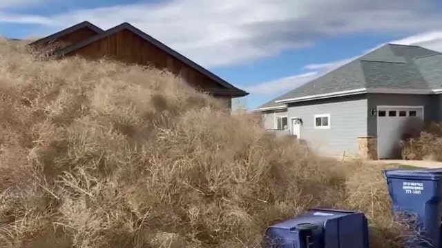

Watch: Montana homes buried under tumbleweed blown in by 60-plus mph wind gusts
Some piles of tumbleweed rose so high that they flowed over the roofs of homes, causing them to almost disappear under a mountain of beige.
Some piles of tumbleweed rose so high that they flowed over the roofs of homes, causing them to almost disappear under a mountain of beige.

FOX 26 Houston Weather Forecast
A weak front moves through Southeast Texas today gradually lower the humidity for Houston. Look for afternoon highs to return to above normal for the next several days. We could even see record high temps tomorrow afternoon. Rain returns to the forecast on Monday but higher chances look to come in the middle of next week.
A weak front moves through Southeast Texas today gradually lower the humidity for Houston. Look for afternoon highs to return to above normal for the next several days. We could even see record high temps tomorrow afternoon. Rain returns to the forecast on Monday but higher chances look to come in the middle of next week.

FOX 26 Wednesday night weather forecast
It was another cool start across Houston and surrounding areas in the 40s and 50s. Tonight will be on the milder side with overnight lows dipping into the 60s for Houston. We'll rebound to the upper 80s Thursday with a weak front moving in. That front will not bring any cooler air but will bring a brief wind shift and some drier air briefly. But get ready for more of that summer heat to push back in. In fact, we'll be near record high temperatures Friday as we soar to the low 90s! Temperatures stay near 90 through Sunday with a gradual drop in temperatures expected as we go through next week. Rain chances will also start to increase by the middle of next week with some tropical moisture being pushed into the area. A bigger temperature drop is likely late next week with another cold front.
It was another cool start across Houston and surrounding areas in the 40s and 50s. Tonight will be on the milder side with overnight lows dipping into the 60s for Houston. We'll rebound to the upper 80s Thursday with a weak front moving in. That front will not bring any cooler air but will bring a brief wind shift and some drier air briefly. But get ready for more of that summer heat to push back in. In fact, we'll be near record high temperatures Friday as we soar to the low 90s! Temperatures stay near 90 through Sunday with a gradual drop in temperatures expected as we go through next week. Rain chances will also start to increase by the middle of next week with some tropical moisture being pushed into the area. A bigger temperature drop is likely late next week with another cold front.

Tropical Weather Forecast - 10-18-2023
We are rolling closer to the end of hurricane season but the tropics remain active. In the Atlantic, Invest 94-L has become Tropical Storm Tammy in the central Atlantic. Tropical Storm Warnings are now out for Barbados, Martinique & Guadeloupe. These Caribbean Islands could get 3-6"+ of rain and tropical storm force winds by Friday and Saturday. After that, Tammy is expected to turn north which would keep it out of the Gulf of Mexico and away from SE Texas. In the Eastern Pacific, Norma has become a hurricane west of Mexico and could send some moisture towards SE TX early next week. Norma will be near the Baja Peninsula by this weekend. There's also a high chance for a Tropical wave to develop south of S. Mexico over the next week.
We are rolling closer to the end of hurricane season but the tropics remain active. In the Atlantic, Invest 94-L has become Tropical Storm Tammy in the central Atlantic. Tropical Storm Warnings are now out for Barbados, Martinique & Guadeloupe. These Caribbean Islands could get 3-6"+ of rain and tropical storm force winds by Friday and Saturday. After that, Tammy is expected to turn north which would keep it out of the Gulf of Mexico and away from SE Texas. In the Eastern Pacific, Norma has become a hurricane west of Mexico and could send some moisture towards SE TX early next week. Norma will be near the Baja Peninsula by this weekend. There's also a high chance for a Tropical wave to develop south of S. Mexico over the next week.

FOX 26 Wednesday evening weather forecast
It was another cool start across Houston and surrounding areas in the 40s and 50s. Tonight will be on the milder side with overnight lows dipping into the 60s for Houston. We'll rebound to the upper 80s Thursday with a weak front moving in. That front will not bring any cooler air but will bring a brief wind shift and some drier air briefly. But get ready for more of that summer heat to push back in. In fact, we'll be near record high temperatures Friday as we soar to the low 90s! Temperatures stay near 90 through Sunday with a gradual drop in temperatures expected as we go through next week. Rain chances will also start to increase by the middle of next week with some tropical moisture being pushed into the area. A bigger temperature drop is likely late next week with another cold front.
It was another cool start across Houston and surrounding areas in the 40s and 50s. Tonight will be on the milder side with overnight lows dipping into the 60s for Houston. We'll rebound to the upper 80s Thursday with a weak front moving in. That front will not bring any cooler air but will bring a brief wind shift and some drier air briefly. But get ready for more of that summer heat to push back in. In fact, we'll be near record high temperatures Friday as we soar to the low 90s! Temperatures stay near 90 through Sunday with a gradual drop in temperatures expected as we go through next week. Rain chances will also start to increase by the middle of next week with some tropical moisture being pushed into the area. A bigger temperature drop is likely late next week with another cold front.

Fox 26 Weather
It was another cool start across Houston and surrounding areas in the 40s and 50s. Tonight will be on the milder side with overnight lows dipping into the 60s for Houston. We'll rebound to the upper 80s Thursday with a weak front moving in. That front will not bring any cooler air but will bring a brief wind shift and some drier air briefly. But get ready for more of that summer heat to push back in. In fact, we'll be near record high temperatures Friday as we soar to the low 90s! Temperatures stay near 90 through Sunday with a gradual drop in temperatures expected as we go through next week. Rain chances will also start to increase by the middle of next week with some tropical moisture being pushed into the area. A bigger temperature drop is likely late next week with another cold front.
It was another cool start across Houston and surrounding areas in the 40s and 50s. Tonight will be on the milder side with overnight lows dipping into the 60s for Houston. We'll rebound to the upper 80s Thursday with a weak front moving in. That front will not bring any cooler air but will bring a brief wind shift and some drier air briefly. But get ready for more of that summer heat to push back in. In fact, we'll be near record high temperatures Friday as we soar to the low 90s! Temperatures stay near 90 through Sunday with a gradual drop in temperatures expected as we go through next week. Rain chances will also start to increase by the middle of next week with some tropical moisture being pushed into the area. A bigger temperature drop is likely late next week with another cold front.

FOX 26 Tuesday night weather forecast
This morning was our coolest in about 211 days since March 20th with Bush Airport making it down to 47 degrees and Hobby Airport making it down to 49 degrees! With lots of sun today, temperatures quickly rebounded with widespread 70s in the area. Look for another clear and cool night with very little wind. Temperatures will dip to the 50s for Houston with some 40s expected north of Houston. Get ready for summer to say "hello" to us once again as we heat up the rest of this week. In fact, we'll be close to 90 by Friday! Weak front will bring a brief wind shift and drop in humidity Friday. But there will only be a very small chance for rain Thursday and Friday. Look for a few more showers next Tuesday.
This morning was our coolest in about 211 days since March 20th with Bush Airport making it down to 47 degrees and Hobby Airport making it down to 49 degrees! With lots of sun today, temperatures quickly rebounded with widespread 70s in the area. Look for another clear and cool night with very little wind. Temperatures will dip to the 50s for Houston with some 40s expected north of Houston. Get ready for summer to say "hello" to us once again as we heat up the rest of this week. In fact, we'll be close to 90 by Friday! Weak front will bring a brief wind shift and drop in humidity Friday. But there will only be a very small chance for rain Thursday and Friday. Look for a few more showers next Tuesday.

FOX 26 Tuesday evening weather forecast
This morning was our coolest in about 211 days since March 20th with Bush Airport making it down to 47 degrees and Hobby Airport making it down to 49 degrees! With lots of sun today, temperatures quickly rebounded with widespread 70s in the area. Look for another clear and cool night with very little wind. Temperatures will dip to the 50s for Houston with some 40s expected north of Houston. Get ready for summer to say "hello" to us once again as we heat up the rest of this week. In fact, we'll be close to 90 by Friday! Weak front will bring a brief wind shift and drop in humidity Friday. But there will only be a very small chance for rain Thursday and Friday. Look for a few more showers next Tuesday.
This morning was our coolest in about 211 days since March 20th with Bush Airport making it down to 47 degrees and Hobby Airport making it down to 49 degrees! With lots of sun today, temperatures quickly rebounded with widespread 70s in the area. Look for another clear and cool night with very little wind. Temperatures will dip to the 50s for Houston with some 40s expected north of Houston. Get ready for summer to say "hello" to us once again as we heat up the rest of this week. In fact, we'll be close to 90 by Friday! Weak front will bring a brief wind shift and drop in humidity Friday. But there will only be a very small chance for rain Thursday and Friday. Look for a few more showers next Tuesday.