


Leaf color tracker: Here’s when fall foliage will peak across US in 2024
The peak of fall foliage can start as early as September, and most locations will peak in either October or November.
The peak of fall foliage can start as early as September, and most locations will peak in either October or November.

Heatwave, Ozone Alert | Fox 26 Houston Weather Forecast
Another round of highs in the mid-90s are expected today across SE Texas. Feels-like temperatures will be near 100 degrees. It is also an Ozone Action Day. Folks with breathing problems are asked to limit outdoor activity. This warm and quiet weather pattern continues into the weekend. Tropics: We are monitoring two areas in the tropics with the chance for development. One is the remnants of Gordon, which would stay out to sea. The second area is in the northwestern Caribbean Sea. At this time, the development chance is low over the next several days. We will continue to monitor the latest forecast models and will keep you posted on the free FOX Local app.
Another round of highs in the mid-90s are expected today across SE Texas. Feels-like temperatures will be near 100 degrees. It is also an Ozone Action Day. Folks with breathing problems are asked to limit outdoor activity. This warm and quiet weather pattern continues into the weekend. Tropics: We are monitoring two areas in the tropics with the chance for development. One is the remnants of Gordon, which would stay out to sea. The second area is in the northwestern Caribbean Sea. At this time, the development chance is low over the next several days. We will continue to monitor the latest forecast models and will keep you posted on the free FOX Local app.

FOX 26 Houston Weather Forecast
Air Quality Alert has been extended through Wednesday morning for higher ozone levels. It's more of the same through the rest of this week with temperatures running about five degrees above normal in the middle 90s and very little rain. Fall begins Sunday but there will be little change to the weather pattern with hot & mostly dry weather persisting. Only one disturbance is being monitored in the Atlantic basin and that's the remnants of Gordon. There's a MEDIUM 40% chance Gordon could regain tropical storm status over the next 7 days. However, Gordon is expected to remain over water.
Air Quality Alert has been extended through Wednesday morning for higher ozone levels. It's more of the same through the rest of this week with temperatures running about five degrees above normal in the middle 90s and very little rain. Fall begins Sunday but there will be little change to the weather pattern with hot & mostly dry weather persisting. Only one disturbance is being monitored in the Atlantic basin and that's the remnants of Gordon. There's a MEDIUM 40% chance Gordon could regain tropical storm status over the next 7 days. However, Gordon is expected to remain over water.

FOX 26 Houston Weather Forecast
Air Quality Alert has been extended through Wednesday morning for higher ozone levels. It's more of the same through the rest of this week with temperatures running about five degrees above normal in the middle 90s and very little rain. Fall begins Sunday but there will be little change to the weather pattern with hot and mostly dry weather persisting. Only one disturbance is being monitored in the Atlantic basin and that's the remnants of Gordon. There's a MEDIUM 40% chance Gordon could regain tropical storm status over the next 7 days. However, Gordon is expected to remain over water.
Air Quality Alert has been extended through Wednesday morning for higher ozone levels. It's more of the same through the rest of this week with temperatures running about five degrees above normal in the middle 90s and very little rain. Fall begins Sunday but there will be little change to the weather pattern with hot and mostly dry weather persisting. Only one disturbance is being monitored in the Atlantic basin and that's the remnants of Gordon. There's a MEDIUM 40% chance Gordon could regain tropical storm status over the next 7 days. However, Gordon is expected to remain over water.

Potential Tropical Cyclone Eight brings heavy rain
What used to be Potential Tropical Cyclone Eight continues to bring rounds of heavy rain to parts of the Carolinas. Close to 20" has fallen in parts of North Carolina around Carolina Beach. The only other system being monitored now is in the central Atlantic. The remnants of Gordon remain disorganized with no threat to land. There's a low 20% chance for Gordon to return to bring a tropical system over the next two days. There's a MEDIUM 40% chance for redevelopment over the next 7 days.
What used to be Potential Tropical Cyclone Eight continues to bring rounds of heavy rain to parts of the Carolinas. Close to 20" has fallen in parts of North Carolina around Carolina Beach. The only other system being monitored now is in the central Atlantic. The remnants of Gordon remain disorganized with no threat to land. There's a low 20% chance for Gordon to return to bring a tropical system over the next two days. There's a MEDIUM 40% chance for redevelopment over the next 7 days.

Mid-90s Heat & Partial Lunar Eclipse | Forecasting with Friends
Texas swelters in a mid-90s heat wave, while tropical systems and a partial lunar eclipse offer some diversion. Get the latest on the heat, storms, and tonight?s sky event.
Texas swelters in a mid-90s heat wave, while tropical systems and a partial lunar eclipse offer some diversion. Get the latest on the heat, storms, and tonight?s sky event.

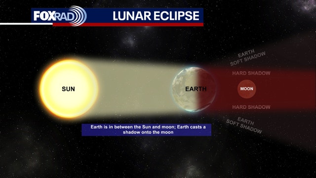
Partial lunar eclipse: What to expect in Houston
FOX 26 Chief Meteorologist Mike Iscovitz explains the partial lunar eclipse expected to be seen in the Houston area/ If conditions are just right, the moon might look slightly reddish. Most of the time partial lunar eclipses are disappointing, but here?s an explainer.
FOX 26 Chief Meteorologist Mike Iscovitz explains the partial lunar eclipse expected to be seen in the Houston area/ If conditions are just right, the moon might look slightly reddish. Most of the time partial lunar eclipses are disappointing, but here?s an explainer.

Mid-90s heat & lunar eclipse tonight | Fox 26 Houston Weather Forecast
After another day in the mid 90s, our late summer heat wave continues today and will be with us for the rest of the week. Rain chances are only isolated at best each day for the next week or so and temperatures will run about 5 degrees above average. Texas will be one of the hottest areas in the country today as well. We have two tropical systems currently, but neither is a threat to Texas. Yesterday, Potential Tropical Cyclone #8 made landfall near the state line of South and North Carolina without being upgraded to Helene. Torrential rainfall caused serious flooding with rainfall totals in excess of 12" across a large swath of North Carolina. Finally, a partial lunar eclipse will be visible tonight after sunset. These types of eclipses are often not very exciting, but if conditions are just right, the moon may appear to have an orange hue after around 9pm.
After another day in the mid 90s, our late summer heat wave continues today and will be with us for the rest of the week. Rain chances are only isolated at best each day for the next week or so and temperatures will run about 5 degrees above average. Texas will be one of the hottest areas in the country today as well. We have two tropical systems currently, but neither is a threat to Texas. Yesterday, Potential Tropical Cyclone #8 made landfall near the state line of South and North Carolina without being upgraded to Helene. Torrential rainfall caused serious flooding with rainfall totals in excess of 12" across a large swath of North Carolina. Finally, a partial lunar eclipse will be visible tonight after sunset. These types of eclipses are often not very exciting, but if conditions are just right, the moon may appear to have an orange hue after around 9pm.

FOX 26 Houston Weather Forecast
Fall is less than a week away but that late summer heat is building with very little rain. Look for above normal temperatures in the middle to upper 90s in Houston with rain chances at 10% or less. Potential Tropical Cyclone Eight is no longer expected to become Tropical Storm Helene because it has pushed inland along the Carolina coast. It will still bring a big flood threat to the Carolinas over the next few days and could produce a few tornadoes and up to 10" of additional rain. Tropical depression Gordon is in the central Atlantic and should not be a threat to land.
Fall is less than a week away but that late summer heat is building with very little rain. Look for above normal temperatures in the middle to upper 90s in Houston with rain chances at 10% or less. Potential Tropical Cyclone Eight is no longer expected to become Tropical Storm Helene because it has pushed inland along the Carolina coast. It will still bring a big flood threat to the Carolinas over the next few days and could produce a few tornadoes and up to 10" of additional rain. Tropical depression Gordon is in the central Atlantic and should not be a threat to land.

FOX 26 Houston Weather Forecast
FOX 26 Meteorologist Remeisha Shade has the latest on the heat building in for the Houston area.
FOX 26 Meteorologist Remeisha Shade has the latest on the heat building in for the Houston area.

Watching Potential Tropical Cyclone 8, Gordon | FOX 26 Tropical Weather Forecast
Potential Tropical Cyclone Eight is no longer expected to become Tropical Storm Helene because it is already moving inland along the Carolina coast. It will still bring a big flood threat to the Carolinas over the next few days and could produce a few tornadoes. 4-8" of rain will be possible with isolated 10" totals. The other system being monitored is Gordon which remains a fairly disorganized Tropical depression. Gordon is in the central Atlantic and should not be a threat to land.
Potential Tropical Cyclone Eight is no longer expected to become Tropical Storm Helene because it is already moving inland along the Carolina coast. It will still bring a big flood threat to the Carolinas over the next few days and could produce a few tornadoes. 4-8" of rain will be possible with isolated 10" totals. The other system being monitored is Gordon which remains a fairly disorganized Tropical depression. Gordon is in the central Atlantic and should not be a threat to land.


Rare lunar eclipse Harvest Moon visible over Texas Tuesday night
Tuesday’s full moon is also a supermoon, meaning the moon will be at its closest point to the Earth in its orbit and may seem bigger and brighter in the sky.
Tuesday’s full moon is also a supermoon, meaning the moon will be at its closest point to the Earth in its orbit and may seem bigger and brighter in the sky.


Tropical Cyclone 8 moves towards Carolinas, may become Tropical Storm Helene
The tropical system that could soon become Tropical Storm Helene is bringing flooding and strong winds to the Carolinas.
The tropical system that could soon become Tropical Storm Helene is bringing flooding and strong winds to the Carolinas.

Hurricane Gear Test: Life+Gear Pro Survivor Premium 72 Hour Pack
As we hit the peak of hurricane season, prebuilt emergency kits are more accessible than ever. But before you buy one, meteorologist John Dawson reviews a trusted survival pack and shares important tips for staying prepared.
As we hit the peak of hurricane season, prebuilt emergency kits are more accessible than ever. But before you buy one, meteorologist John Dawson reviews a trusted survival pack and shares important tips for staying prepared.

Warm week ahead | Fox 26 Houston Weather Update
Following a very warm weekend with highs in the mid 90s, that overall trend will continue this week with only slight day-to-day changes. Expect daily afternoon highs in the low to mid 90s with lows in the low to mid 70s. Storms are not likely, but one or two could periodically pop up mostly during the late afternoons. There are two tropical systems to watch today, but neither is near Texas. A system that is expected to become Tropical Storm Helene (or get very close to tropical storm status) will soak North and South Carolina with heavy downpours and occasional gusty winds today and Tuesday. In the far-off central Atlantic Ocean, Tropical Storm Gordon was downgraded to a depression over the weekend, but could regain tropical storm strength this week over the middle of the ocean, so no effect on land. Otherwise, the fall season begins this Sunday morning.
Following a very warm weekend with highs in the mid 90s, that overall trend will continue this week with only slight day-to-day changes. Expect daily afternoon highs in the low to mid 90s with lows in the low to mid 70s. Storms are not likely, but one or two could periodically pop up mostly during the late afternoons. There are two tropical systems to watch today, but neither is near Texas. A system that is expected to become Tropical Storm Helene (or get very close to tropical storm status) will soak North and South Carolina with heavy downpours and occasional gusty winds today and Tuesday. In the far-off central Atlantic Ocean, Tropical Storm Gordon was downgraded to a depression over the weekend, but could regain tropical storm strength this week over the middle of the ocean, so no effect on land. Otherwise, the fall season begins this Sunday morning.

Tropical Cyclone Eight Forms | Tropical update
Potential Tropical Cyclone EIGHT has formed off the coast of South Carolina. This system will bring heavy rain and possible coastal flooding early this week. Gordon has been downgraded to a Tropical Depression but could become stronger later in the week.
Potential Tropical Cyclone EIGHT has formed off the coast of South Carolina. This system will bring heavy rain and possible coastal flooding early this week. Gordon has been downgraded to a Tropical Depression but could become stronger later in the week.

Southeast Texas to witness rare Supermoon and lunar eclipse Tuesday night
Tuesday night's full moon will be extra special. Southeast Texas will not only experience a full moon Tuesday night but also a Partial Lunar Eclipse.
Tuesday night's full moon will be extra special. Southeast Texas will not only experience a full moon Tuesday night but also a Partial Lunar Eclipse.

FOX 26 Houston Weather Forecast
Houston is back to a mostly quiet weather pattern and it looks to persists for the next several days. Southeast Texas should plan for more late summer heat with very low rain chances. Afternoon highs are back in the upper 90s!
Houston is back to a mostly quiet weather pattern and it looks to persists for the next several days. Southeast Texas should plan for more late summer heat with very low rain chances. Afternoon highs are back in the upper 90s!

Tropical Storm Gordan in Atlantic: Tropical update
Tropical Storm Gordon is out in the Atlantic but an area of low pressure of the coast of The Carolinas is much more of a concern. Gordon will struggle and stay out in the Atlantic but heavy rain and the chance for flooding will find its way to the East Coast of the US.
Tropical Storm Gordon is out in the Atlantic but an area of low pressure of the coast of The Carolinas is much more of a concern. Gordon will struggle and stay out in the Atlantic but heavy rain and the chance for flooding will find its way to the East Coast of the US.

FOX 26 Houston Weather Forecast
We have a warm and quiet weather day across Houston today. Highs will soar to the mid-90s with a few passing clouds. Sunday brings the chance for a few showers during the evening hours. Warm and mostly dry weather is expected through next week. Stay hydrated and enjoy your weekend!
We have a warm and quiet weather day across Houston today. Highs will soar to the mid-90s with a few passing clouds. Sunday brings the chance for a few showers during the evening hours. Warm and mostly dry weather is expected through next week. Stay hydrated and enjoy your weekend!