


Houston traffic: Icy roads, black ice remain Thursday; list, map
Houston police say there are still areas of black ice causing crashes on Thursday morning. Here's a look at road conditions.
Houston police say there are still areas of black ice causing crashes on Thursday morning. Here's a look at road conditions.

Houston weather: Cold Thursday morning in the 30s
Southeast Texas is waking up to below and near freezing temperatures. Any leftover moisture will refreeze overnight, so be careful while driving on bridges and overpasses. Highs this afternoon will rise to the low-50s with lots of sunshine.
Southeast Texas is waking up to below and near freezing temperatures. Any leftover moisture will refreeze overnight, so be careful while driving on bridges and overpasses. Highs this afternoon will rise to the low-50s with lots of sunshine.

Houston weather: Chilly start Thursday before warming up
Highs on Thursday have a good chance of hitting the low 50s with lots of sunshine. That should help to melt any remaining snow or ice across the Houston area.
Highs on Thursday have a good chance of hitting the low 50s with lots of sunshine. That should help to melt any remaining snow or ice across the Houston area.


Keeping pipes protected through the final freezing temperatures
As Houston faces its last night of freezing temperatures, residents are urged to take precautions to protect their plumbing. Plumber Hector Morales shares essential tips, such as wrapping pipes with insulation and maintaining water flow, to prevent them from bursting. With icy roads delaying repair services, these preventive measures are crucial to avoid costly damage until the weather warms up.
As Houston faces its last night of freezing temperatures, residents are urged to take precautions to protect their plumbing. Plumber Hector Morales shares essential tips, such as wrapping pipes with insulation and maintaining water flow, to prevent them from bursting. With icy roads delaying repair services, these preventive measures are crucial to avoid costly damage until the weather warms up.

Houston weather: Hobby Airport reopens following weather storm
The winter weather forced cancellations of flights into and out of both Houston airports. However, that's now over.
The winter weather forced cancellations of flights into and out of both Houston airports. However, that's now over.

Houston weather: Another night of freezing weather on the way
Following a quiet, slightly milder day, ice will be much more isolated in nature overnight tonight even as lows fall slightly below freezing. Still watch out for a few icy spots, especially on bridges and overpasses. Areas that have constantly been in the shade have a higher shot for some lingering ice on the roads as well.
Following a quiet, slightly milder day, ice will be much more isolated in nature overnight tonight even as lows fall slightly below freezing. Still watch out for a few icy spots, especially on bridges and overpasses. Areas that have constantly been in the shade have a higher shot for some lingering ice on the roads as well.

Houston weather: Protecting pipes from another night of freezing weather
After days of freezing weather, we're almost in the clear. However, one more night of freezing weather is on the way, and you need to take care of your pipes and make sure they're protected.
After days of freezing weather, we're almost in the clear. However, one more night of freezing weather is on the way, and you need to take care of your pipes and make sure they're protected.

Houston Mayor John Whitmire praises city officials following winter storm
Houston Mayor John Whitmire said on Wednesday that he's thankful that there have been no fatalities due to traffic accidents.
Houston Mayor John Whitmire said on Wednesday that he's thankful that there have been no fatalities due to traffic accidents.

Houston weather: Houston airports reopen following winter storm
Houston's two airports reopened after being closed for 24 hours because of the winter storm. Now, airline passengers are trying to get things back on track.
Houston's two airports reopened after being closed for 24 hours because of the winter storm. Now, airline passengers are trying to get things back on track.

Houston weather: School closures and delays for Thursday, Jan. 23
Several Houston area school districts have opted to delay or close on Thursday.
Several Houston area school districts have opted to delay or close on Thursday.
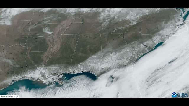

Snow in Florida: NOAA satellite shows historic winter storm, US snowfall from space
As the historic winter storm that traveled across the southern U.S. heads east, it's leaving snowfall from Texas to North Carolina. This image was captured by a NOAA satellite showing several inches of snow left on the ground.
As the historic winter storm that traveled across the southern U.S. heads east, it's leaving snowfall from Texas to North Carolina. This image was captured by a NOAA satellite showing several inches of snow left on the ground.


Houston weather: Where Tuesday's snowfall ranks in the record books
Tuesday's snowfall fell short of Houston's all-time list.
Tuesday's snowfall fell short of Houston's all-time list.


Houston weather: Chance of rain this weekend
The snow and ice is almost gone. We could see some rain this weekend.
The snow and ice is almost gone. We could see some rain this weekend.

Houston Mayor John Whitmire on winter weather response
Houston officials weigh in on the response to the winter weather in the city.
Houston officials weigh in on the response to the winter weather in the city.

Houston weather: Jan. 22 afternoon update
FOX 26 meteorologist John Dawson takes a look a temperatures across Houston and the chance for rain later this week.
FOX 26 meteorologist John Dawson takes a look a temperatures across Houston and the chance for rain later this week.


Houston ISD to resume classes on Thursday
With temperatures trending up, officials with Houston ISD are saying it is safe to resume normal operations.
With temperatures trending up, officials with Houston ISD are saying it is safe to resume normal operations.


Houston closures: Businesses, offices closed on Wednesday due to winter weather
Some businesses and government services remain closed on Wednesday after a winter storm brought snow and icy roads to Houston.
Some businesses and government services remain closed on Wednesday after a winter storm brought snow and icy roads to Houston.

Houston road conditions | 11 a.m. update
A look at road conditions across the Houston area after black ice formed overnight.
A look at road conditions across the Houston area after black ice formed overnight.


LIVE UPDATES: Houston weather, snow, icy road conditions, power outages, closures
Live updates on Houston weather conditions and the forecast, snow, icy road locations, school closures, cancelations, power outages and more.
Live updates on Houston weather conditions and the forecast, snow, icy road locations, school closures, cancelations, power outages and more.


How to turn off the water to your house
First, try to call the city and see if they can dispatch someone to turn off the water to your house if you have a busted pipe. But, it is always good to have the tools on hand if there is an emergency. Here is what to do.
First, try to call the city and see if they can dispatch someone to turn off the water to your house if you have a busted pipe. But, it is always good to have the tools on hand if there is an emergency. Here is what to do.