


FOX 26 Houston Weather Forecast: More rain possible Friday
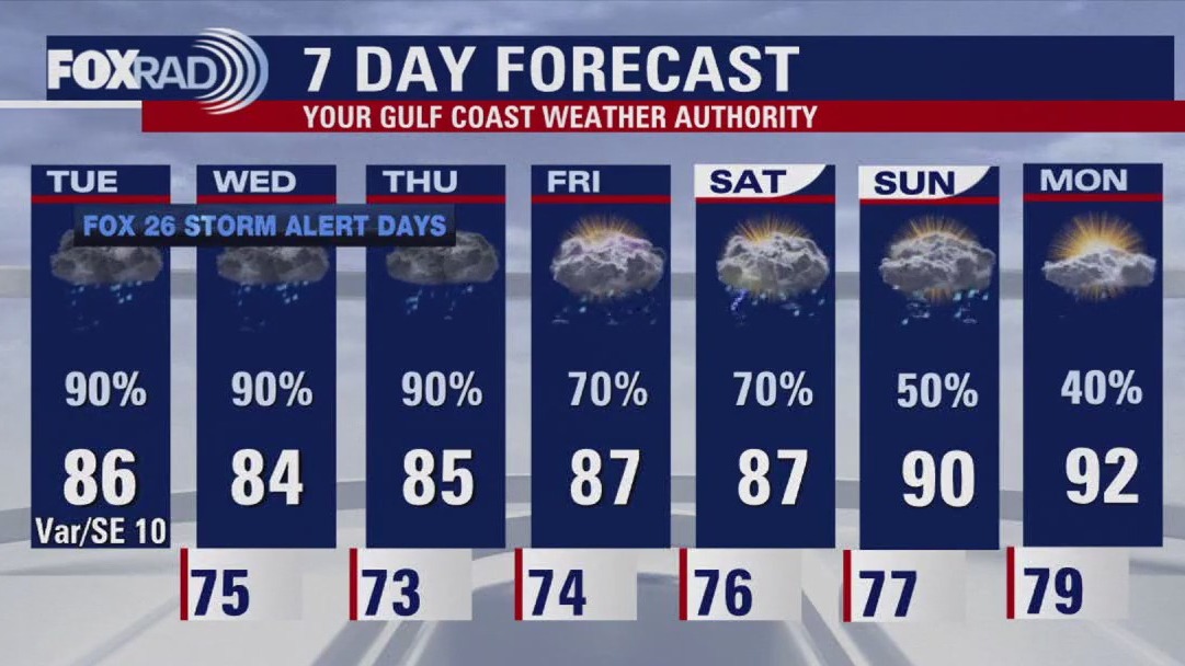
Friday is once again a FOX 26 Storm Alert Day. Flood Watch has been extended until 4 pm Friday for Houston and areas south and east of Houston. An additional 1-4" of rain is possible through Friday evening, especially south of I-10. Watch for flooded streets & avoid those areas if possible. Rain chances remain around 60-70% this weekend which will keep a low flood threat in place. Here's the good news. Weather pattern finally makes a major shift next week to a hotter and drier pattern. That means a return to more sunshine and the 90s. Tropics remain quiet across the Atlantic basin with no major action expected through the end of July. Keep track of weather where you live and get the latest on the tropics on our smart TV app, Fox Local!
Friday is once again a FOX 26 Storm Alert Day. Flood Watch has been extended until 4 pm Friday for Houston and areas south and east of Houston. An additional 1-4" of rain is possible through Friday evening, especially south of I-10. Watch for flooded streets & avoid those areas if possible. Rain chances remain around 60-70% this weekend which will keep a low flood threat in place. Here's the good news. Weather pattern finally makes a major shift next week to a hotter and drier pattern. That means a return to more sunshine and the 90s. Tropics remain quiet across the Atlantic basin with no major action expected through the end of July. Keep track of weather where you live and get the latest on the tropics on our smart TV app, Fox Local!


FOX 26 Houston Weather Forecast
Friday is once again a FOX 26 Storm Alert Day. Flood Watch has been extended until 4 p.m. Friday for Houston and areas south and east of Houston. An additional 1-4" of rain is possible through Friday evening, especially south of I-10. Watch for flooded streets & avoid those areas if possible. Rain chances remain around 60-70% this weekend which will keep a low flood threat in place. Here's the good news. Weather pattern finally makes a major shift next week to a hotter and drier pattern. That means a return to more sunshine and the 90s. Tropics remain quiet across the Atlantic basin with no major action expected through the end of July. Keep track of the weather where you live and get the latest on the tropics on our smart TV app FOX Local!
Friday is once again a FOX 26 Storm Alert Day. Flood Watch has been extended until 4 p.m. Friday for Houston and areas south and east of Houston. An additional 1-4" of rain is possible through Friday evening, especially south of I-10. Watch for flooded streets & avoid those areas if possible. Rain chances remain around 60-70% this weekend which will keep a low flood threat in place. Here's the good news. Weather pattern finally makes a major shift next week to a hotter and drier pattern. That means a return to more sunshine and the 90s. Tropics remain quiet across the Atlantic basin with no major action expected through the end of July. Keep track of the weather where you live and get the latest on the tropics on our smart TV app FOX Local!


Fox 26 Houston Weather Forecast
Watch out for another risk for flooding today especially from Houston to Sugar Land, Pearland, Clear Lake, Galveston and Baytown (and surrounding cities). Today's pattern is roughly the same as it's been all week with a dip in the jet stream helping to pull deep tropical moisture up from the Gulf of Mexico and a stationary front stuck over our area. A flood watch is in effect for most of Southeast Texas until 4pm today. If you're craving sunshine and less rain, next week is partly sunny, hot and very humid.
Watch out for another risk for flooding today especially from Houston to Sugar Land, Pearland, Clear Lake, Galveston and Baytown (and surrounding cities). Today's pattern is roughly the same as it's been all week with a dip in the jet stream helping to pull deep tropical moisture up from the Gulf of Mexico and a stationary front stuck over our area. A flood watch is in effect for most of Southeast Texas until 4pm today. If you're craving sunshine and less rain, next week is partly sunny, hot and very humid.


FOX 26 Houston Weather Forecast
A flood watch is in effect through 4 p.m. Storms and heavy rain are expected this morning and early afternoon. Some flooding is possible. High temps in the low 80s.
A flood watch is in effect through 4 p.m. Storms and heavy rain are expected this morning and early afternoon. Some flooding is possible. High temps in the low 80s.

FOX 26 Houston Weather Forecast: Heavy rain possible on Thursday
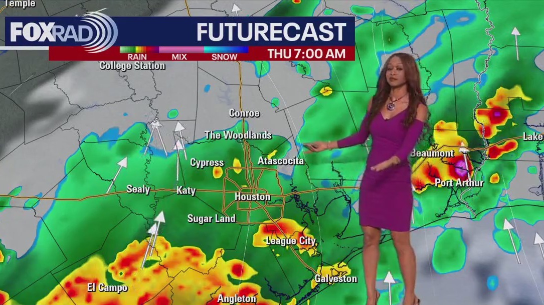
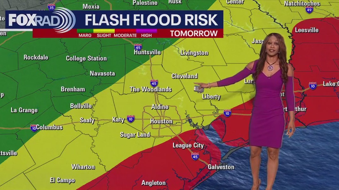
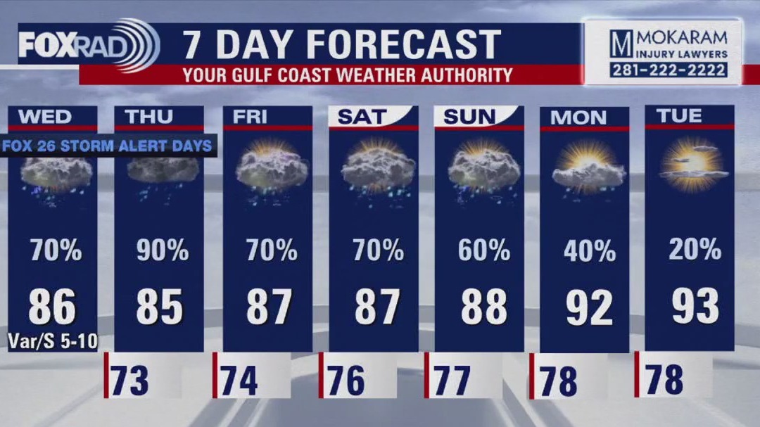
Flood Watch has been removed from our northern counties and extended for our central and Southeastern counties until 4pm Thursday. Heaviest rain bands are expected to set up along the coast Thursday morning and an additional 3-6" of rain will be possible in this area. Flood threat is a 3 of 5 "Moderate" risk for Galveston Thursday and a 2 of 5 "Slight" risk for Houston. Drive with caution and avoid any flooded roads. Thursday is once again a FOX 26 Storm Alert Day. Rain chances remain on the higher side Friday and Saturday. But there's light at the end of the tunnel! Hotter and drier weather should gradually return next week as we break out of this super soggy weather pattern. Get specific forecasts for weather where you live on our smart TV app, Fox Local, and our FOX 26 weather app!
Flood Watch has been removed from our northern counties and extended for our central and Southeastern counties until 4pm Thursday. Heaviest rain bands are expected to set up along the coast Thursday morning and an additional 3-6" of rain will be possible in this area. Flood threat is a 3 of 5 "Moderate" risk for Galveston Thursday and a 2 of 5 "Slight" risk for Houston. Drive with caution and avoid any flooded roads. Thursday is once again a FOX 26 Storm Alert Day. Rain chances remain on the higher side Friday and Saturday. But there's light at the end of the tunnel! Hotter and drier weather should gradually return next week as we break out of this super soggy weather pattern. Get specific forecasts for weather where you live on our smart TV app, Fox Local, and our FOX 26 weather app!

FOX 26 Houston Weather Forecast
Flood Watch has been removed from our northern counties and extended for our central and Southeastern counties until 4pm Thursday. Heaviest rain bands are expected to set up along the coast Thursday morning and an additional 3-6" of rain will be possible in this area. Flood threat is a 3 of 5 "Moderate" risk for Galveston Thursday and a 2 of 5 "Slight" risk for Houston. Drive with caution and avoid any flooded roads. Thursday is once again a FOX 26 Storm Alert Day. Rain chances remain on the higher side Friday and Saturday. But there's light at the end of the tunnel! Hotter and drier weather should gradually return next week as we break out of this super soggy weather pattern. Get specific forecasts for weather where you live on our smart tv app Fox Local and our FOX 26 weather app!
Flood Watch has been removed from our northern counties and extended for our central and Southeastern counties until 4pm Thursday. Heaviest rain bands are expected to set up along the coast Thursday morning and an additional 3-6" of rain will be possible in this area. Flood threat is a 3 of 5 "Moderate" risk for Galveston Thursday and a 2 of 5 "Slight" risk for Houston. Drive with caution and avoid any flooded roads. Thursday is once again a FOX 26 Storm Alert Day. Rain chances remain on the higher side Friday and Saturday. But there's light at the end of the tunnel! Hotter and drier weather should gradually return next week as we break out of this super soggy weather pattern. Get specific forecasts for weather where you live on our smart tv app Fox Local and our FOX 26 weather app!

Fox 26 Houston Weather Forecast
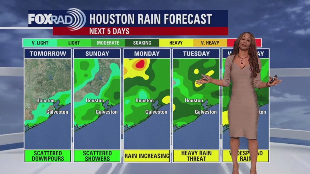
Enjoy a few breaks in the rain when you can, because several rounds of rain are coming our way today and each day through the weekend. Abundant, deep tropical moisture is streaming in from the Gulf and an active jet stream pattern will provide rounds of rain for at least the next 5 days. Overall rainfall accumulations could top 4-8" and this is on top of up to 5" that fell on Monday and 6" on Tuesday in some spots. The best thing you can do to keep yourself safe is to drive very carefully and avoid driving into water covered roadways. Clear skies and hotter weather should return early next week.
Enjoy a few breaks in the rain when you can, because several rounds of rain are coming our way today and each day through the weekend. Abundant, deep tropical moisture is streaming in from the Gulf and an active jet stream pattern will provide rounds of rain for at least the next 5 days. Overall rainfall accumulations could top 4-8" and this is on top of up to 5" that fell on Monday and 6" on Tuesday in some spots. The best thing you can do to keep yourself safe is to drive very carefully and avoid driving into water covered roadways. Clear skies and hotter weather should return early next week.


FOX 26 Houston Weather Forecast
Today is a FOX 26 Storm Alert Day. Heavy rain is likely off and on through the day and a flood watch is in effect. High temperatures in the mid 80s.
Today is a FOX 26 Storm Alert Day. Heavy rain is likely off and on through the day and a flood watch is in effect. High temperatures in the mid 80s.

FOX 26 Houston Weather Forecast: Flood watch in effect Wednesday
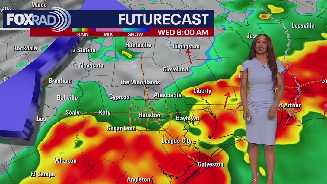
Flood Watch has been issued from 6am until 9pm Wednesday for the entire area with more rounds of heavy rain likely. Even this evening the threat for flooding will remain elevated, especially just north of Houston where some flood alerts have been issued. But models are showing a big batch of rain moving from the coast inland Wednesday morning into the afternoon. This could mean more flooded streets and problems for the AM rush. Rain chances stay very high through Thursday with scattered downpours impacting your weekend plans. Rain chances get a bit lower next week but some rain is still possible. Enjoy the cooler temperatures but watch out for flooded roads! Make sure to download the FOX 26 Weather App on your phone and keep track of the wet weather where you live at home on the big screen with our smart TV app, FOX Local!
Flood Watch has been issued from 6am until 9pm Wednesday for the entire area with more rounds of heavy rain likely. Even this evening the threat for flooding will remain elevated, especially just north of Houston where some flood alerts have been issued. But models are showing a big batch of rain moving from the coast inland Wednesday morning into the afternoon. This could mean more flooded streets and problems for the AM rush. Rain chances stay very high through Thursday with scattered downpours impacting your weekend plans. Rain chances get a bit lower next week but some rain is still possible. Enjoy the cooler temperatures but watch out for flooded roads! Make sure to download the FOX 26 Weather App on your phone and keep track of the wet weather where you live at home on the big screen with our smart TV app, FOX Local!


FOX 26 Houston Weather Forecast
Flood Watch has been issued from 6am until 9pm Wednesday for the entire area with more rounds of heavy rain likely. Even this evening the threat for flooding will remain elevated, especially just north of Houston where some flood alerts have been issued. But models are showing a big batch of rain moving from the coast inland Wednesday morning into the afternoon. This could mean more flooded streets and problems for the AM rush. Rain chances stay very high through Thursday with scattered downpours impacting your weekend plans. Rain chances get a bit lower next week but some rain is still possible. Enjoy the cooler temperatures but watch out for flooded roads! Make sure to download the FOX 26 Weather App on your phone and keep track of the wet weather where you live at home on the big screen with our smart tv app FOX Local!
Flood Watch has been issued from 6am until 9pm Wednesday for the entire area with more rounds of heavy rain likely. Even this evening the threat for flooding will remain elevated, especially just north of Houston where some flood alerts have been issued. But models are showing a big batch of rain moving from the coast inland Wednesday morning into the afternoon. This could mean more flooded streets and problems for the AM rush. Rain chances stay very high through Thursday with scattered downpours impacting your weekend plans. Rain chances get a bit lower next week but some rain is still possible. Enjoy the cooler temperatures but watch out for flooded roads! Make sure to download the FOX 26 Weather App on your phone and keep track of the wet weather where you live at home on the big screen with our smart tv app FOX Local!

FOX 26 Houston Weather Forecast
Today is a FOX 26 Storm Alert Day. Expect rounds of heavy rain with some isolated areas of flooding possible. Highs in the mid 80s.
Today is a FOX 26 Storm Alert Day. Expect rounds of heavy rain with some isolated areas of flooding possible. Highs in the mid 80s.


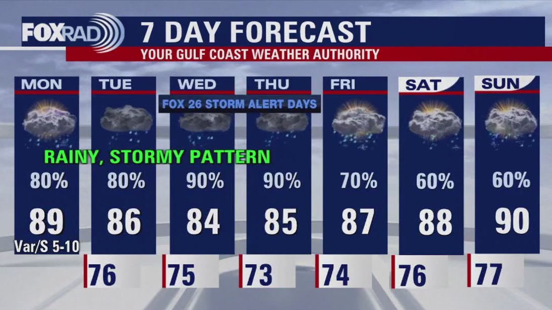
FOX 26 Houston Weather Forecast: Wet weather pattern this week
Flooding will be the weather word of the week and the biggest weather hazard if you have outdoor plans. Expect several waves of heavy rain through the end of the week which will likely amount to 5-10" of rain for much of the area through this weekend with isolated higher amounts. That means streets could quickly flood and rivers and bayous will be on the rise. So be on alert for flooding and avoid these areas! Rain is expected to be the most widespread on Wednesday and Thursday and those are Fox 26 Storm Alert Days. At least temperatures will be more comfortable for July! Make sure to keep up with the latest watches and warnings by downloading our FOX 26 Weather app and by getting detailed storm and flood updates on our smart TV app, Fox Local!
Flooding will be the weather word of the week and the biggest weather hazard if you have outdoor plans. Expect several waves of heavy rain through the end of the week which will likely amount to 5-10" of rain for much of the area through this weekend with isolated higher amounts. That means streets could quickly flood and rivers and bayous will be on the rise. So be on alert for flooding and avoid these areas! Rain is expected to be the most widespread on Wednesday and Thursday and those are Fox 26 Storm Alert Days. At least temperatures will be more comfortable for July! Make sure to keep up with the latest watches and warnings by downloading our FOX 26 Weather app and by getting detailed storm and flood updates on our smart TV app, Fox Local!


FOX 26 Houston Weather Forecast: Wet week ahead
The FOX 26 News Team presents a comprehensive look at local, regional, and national news events of the day.
The FOX 26 News Team presents a comprehensive look at local, regional, and national news events of the day.

FOX 26 Houston Weather Forecast
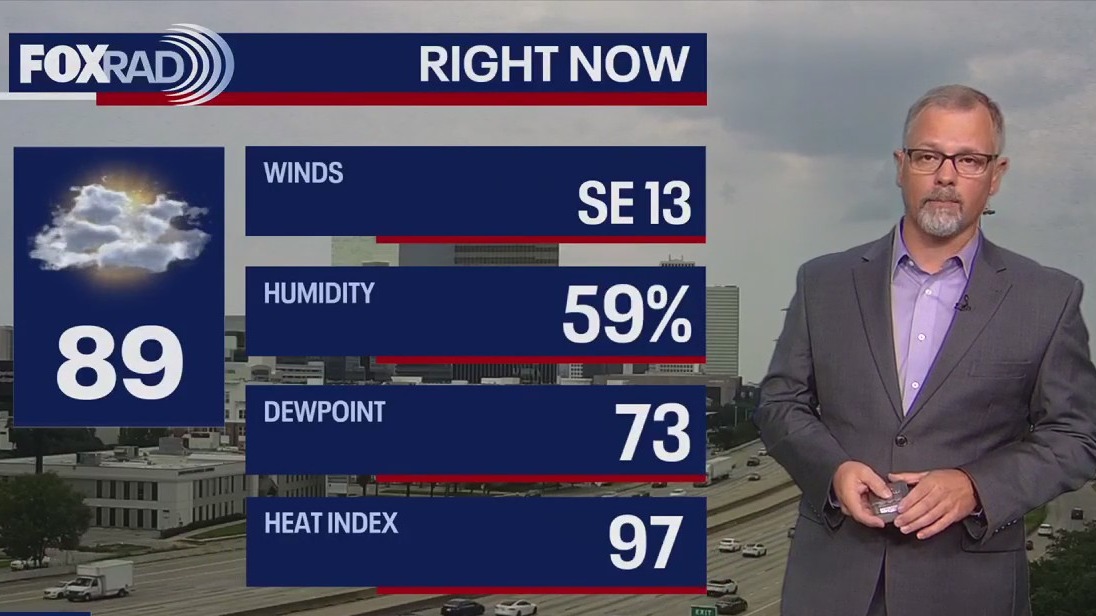
Mostly cloudy and humid with on and off rain through the day and a few heavy spots. Highs near 90.
Mostly cloudy and humid with on and off rain through the day and a few heavy spots. Highs near 90.


Fox 26 Houston Weather Forecast
Get ready for a wet week in Houston. Rounds of heavy rain and storms begin on Monday and continue through most of the week. Widespread rain could add up to 3-5 inches in total across Southeast Texas. Be safe moving around as localized flooding is expected at times.
Get ready for a wet week in Houston. Rounds of heavy rain and storms begin on Monday and continue through most of the week. Widespread rain could add up to 3-5 inches in total across Southeast Texas. Be safe moving around as localized flooding is expected at times.

FOX 26 Houston Weather Forecast
A stalled front across Southeast Texas keeps heavy downpours possible over the rest of the weekend. There is not much left of this boundary but combined with daytime heat, Sunday afternoon will be a hit-or-miss situation with the thunderstorms. Rain becomes more widespread as we move into next week. The Houston area should expect 3-6 inches of rain Monday through Thursday. Be aware of the possibility of flooded roads as you move through your week.
A stalled front across Southeast Texas keeps heavy downpours possible over the rest of the weekend. There is not much left of this boundary but combined with daytime heat, Sunday afternoon will be a hit-or-miss situation with the thunderstorms. Rain becomes more widespread as we move into next week. The Houston area should expect 3-6 inches of rain Monday through Thursday. Be aware of the possibility of flooded roads as you move through your week.

FOX 26 Houston Weather Forecast: Rain remains in the forecast
Rain will become even more widespread next week and that is when the flood threat starts to increase. Models are showing the potential for 3-6" of rain through the middle of next week. So watch out for any flooded areas. At least temperatures will be comfortable for July next week with high temperatures in the 80s.
Rain will become even more widespread next week and that is when the flood threat starts to increase. Models are showing the potential for 3-6" of rain through the middle of next week. So watch out for any flooded areas. At least temperatures will be comfortable for July next week with high temperatures in the 80s.


FOX 26 Houston Weather Forecast
Stalled cold front will remain close to the Houston area this weekend which will mean scattered showers and storms. Best chance will be in the afternoon & early evening. Rain becomes even more widespread next week and that is when the flood threat starts to increase. Models are showing the potential for 3-6" of rain through the middle of next week. So watch out for any flooded areas. At least temperatures will be comfortable for July next week with high temperatures in the 80s.
Stalled cold front will remain close to the Houston area this weekend which will mean scattered showers and storms. Best chance will be in the afternoon & early evening. Rain becomes even more widespread next week and that is when the flood threat starts to increase. Models are showing the potential for 3-6" of rain through the middle of next week. So watch out for any flooded areas. At least temperatures will be comfortable for July next week with high temperatures in the 80s.


FOX 26 Houston Weather Forecast
A few morning showers or storms, then warm and humid with isolated afternoon storms. Highs in the low 90s.
A few morning showers or storms, then warm and humid with isolated afternoon storms. Highs in the low 90s.


FOX 26 Houston Weather Forecast: More rain coming
A front will linger near the area this weekend keeping scattered showers and storms in the forecast. Unsettled weather pattern sticks around next week widespread rain likely. Models are showing an additional 3-5" of rain fire the Houston area through early next week. It will still be humid but temperatures will be a bit more comfortable with afternoon highs in the 80s Saturday through next week. Keep track of weather where you live and get a detailed tropics update by downloading our FOX 26 Weather App and our smart TV app, FOX Local!
A front will linger near the area this weekend keeping scattered showers and storms in the forecast. Unsettled weather pattern sticks around next week widespread rain likely. Models are showing an additional 3-5" of rain fire the Houston area through early next week. It will still be humid but temperatures will be a bit more comfortable with afternoon highs in the 80s Saturday through next week. Keep track of weather where you live and get a detailed tropics update by downloading our FOX 26 Weather App and our smart TV app, FOX Local!