

Friday weather forecast
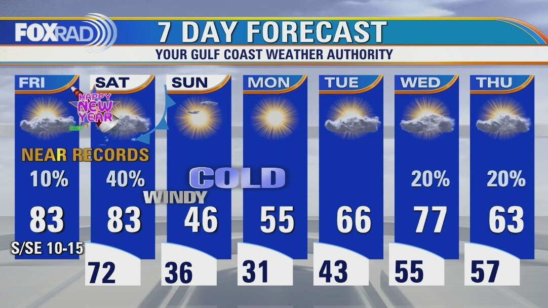
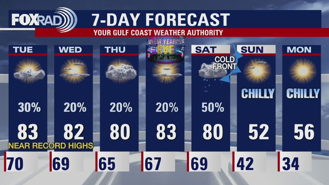
Our unprecedented string of record warmth will come to a screeching halt Saturday night, but in the meantime, muggy conditions will continue. Look for record highs today followed by a muggy and misty New Year?s Eve. Temperature could reach the mid 80s Saturday, then get ready as temps could drop by 40-50 degrees by Sunday morning. A freeze watch is in effect Sunday morning and lows could drop below 30 on Monday morning.
Our unprecedented string of record warmth will come to a screeching halt Saturday night, but in the meantime, muggy conditions will continue. Look for record highs today followed by a muggy and misty New Year?s Eve. Temperature could reach the mid 80s Saturday, then get ready as temps could drop by 40-50 degrees by Sunday morning. A freeze watch is in effect Sunday morning and lows could drop below 30 on Monday morning.
Friday morning weather forecast
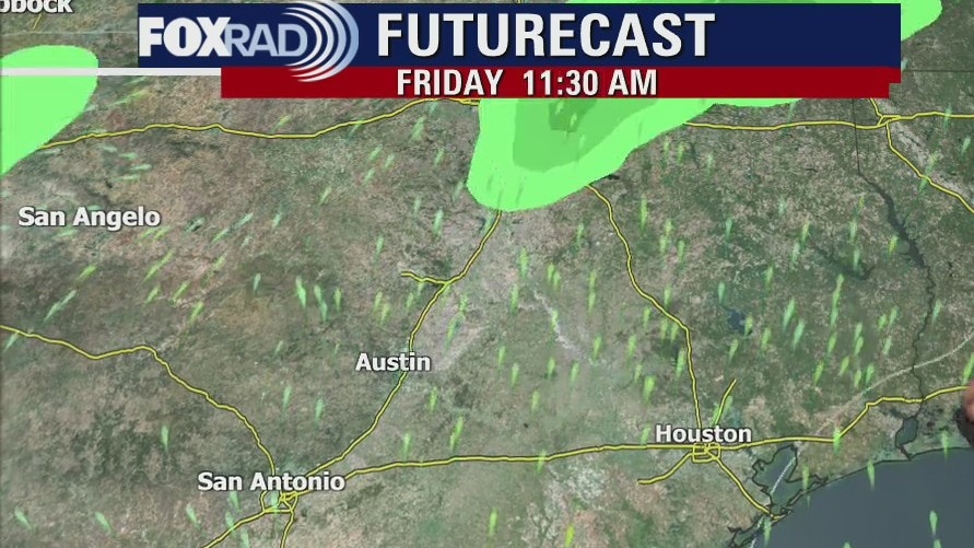
The cold front is still on track to arrive in Houston this weekend! FREEZE WATCH has been issued for the northern counties in the FOX26 viewing area for Saturday night and Sunday morning.
The cold front is still on track to arrive in Houston this weekend! FREEZE WATCH has been issued for the northern counties in the FOX26 viewing area for Saturday night and Sunday morning.
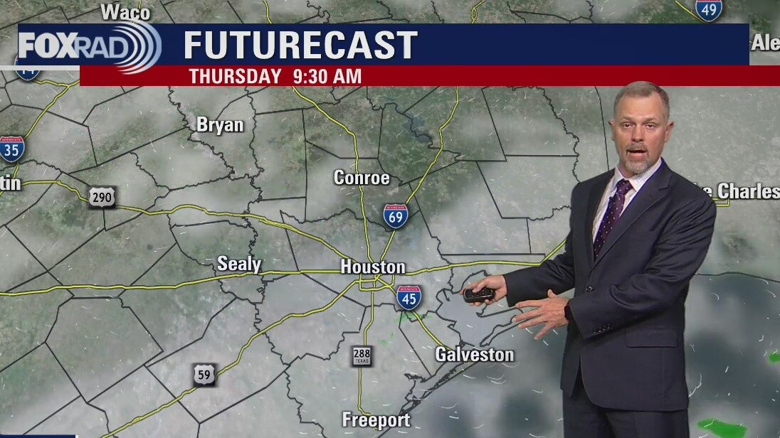
Thursday evening weather forecast with Meteorologist John Dawson
The cold front is still on track to arrive in Houston this weekend! FREEZE WATCH has been issued for the northern counties in the FOX26 viewing area for Saturday night and Sunday morning.
The cold front is still on track to arrive in Houston this weekend! FREEZE WATCH has been issued for the northern counties in the FOX26 viewing area for Saturday night and Sunday morning.
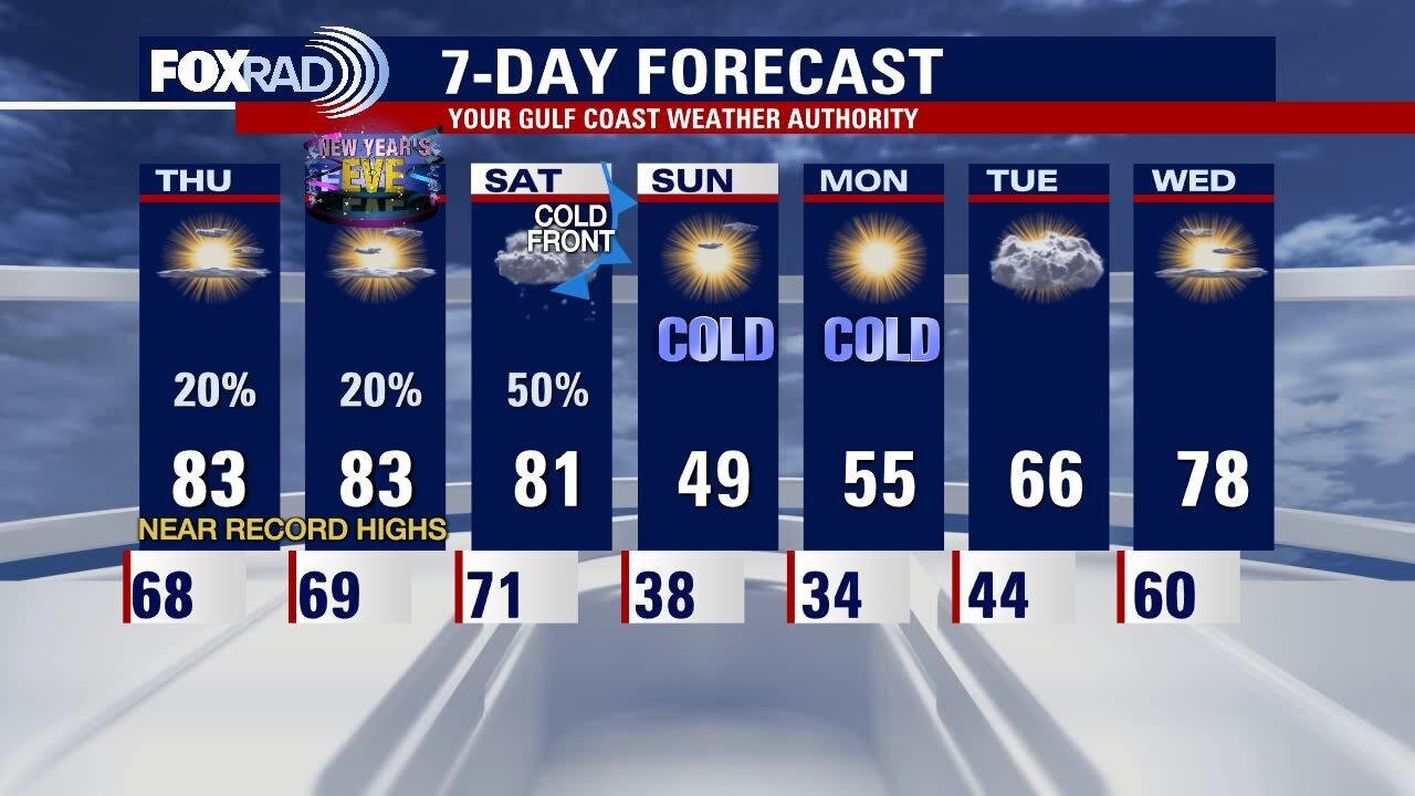
Thursday weather forecast
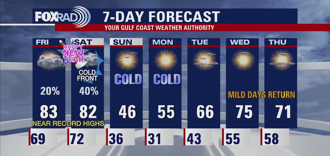
After widespread morning fog, we're looking for more mild weather today with highs in the low 80s. We will end with the year with more warm weather and highs near records on Friday. Midnight on New Year's Eve night looks mild with some drizzle possible. January 1st will be our last warm day with a major cold front expected Saturday night. Freezing temperatures will be possible Sunday and Monday morning.
After widespread morning fog, we're looking for more mild weather today with highs in the low 80s. We will end with the year with more warm weather and highs near records on Friday. Midnight on New Year's Eve night looks mild with some drizzle possible. January 1st will be our last warm day with a major cold front expected Saturday night. Freezing temperatures will be possible Sunday and Monday morning.
Thursday morning weather forecast
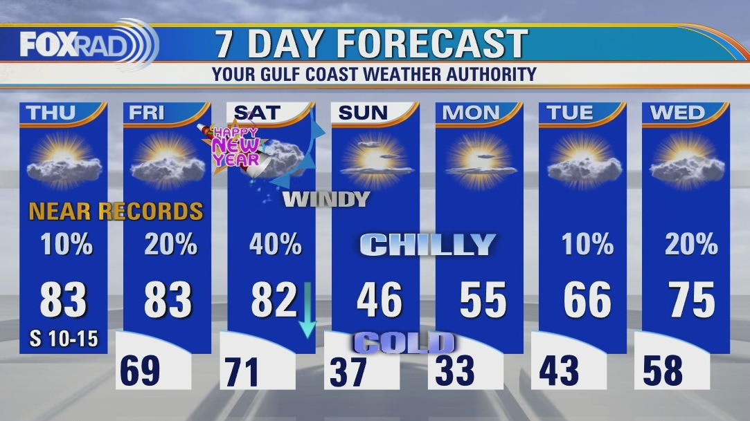
Houston will continue to see record warm temperatures this week until a strong cold front moves through Southeast Texas on Saturday. Happy New Year!
Houston will continue to see record warm temperatures this week until a strong cold front moves through Southeast Texas on Saturday. Happy New Year!
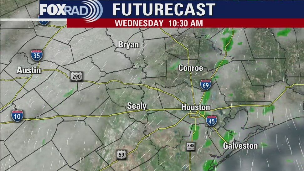
Wednesday evening weather forecast with Meteorologist John Dawson
Houston will continue to see record warm temperatures this week until a strong cold front moves through Southeast Texas on Saturday. Happy New Year!
Houston will continue to see record warm temperatures this week until a strong cold front moves through Southeast Texas on Saturday. Happy New Year!
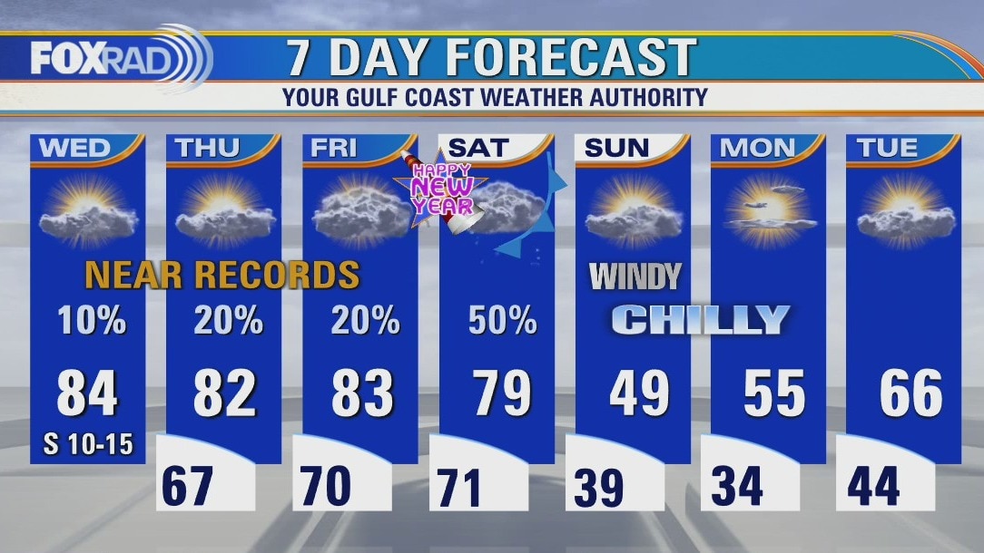
Wednesday weather forecast
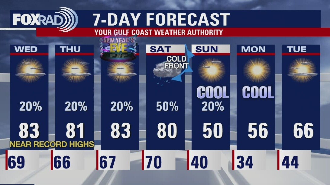
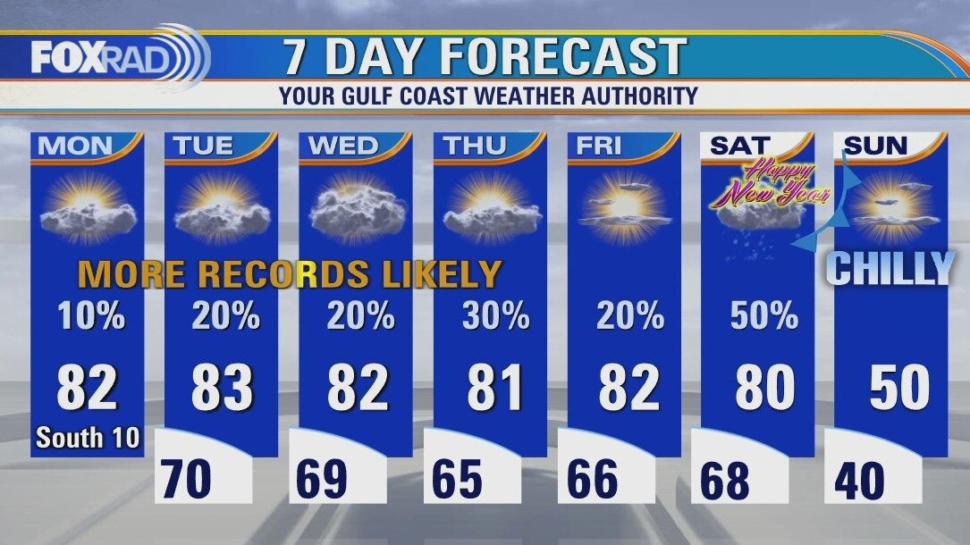
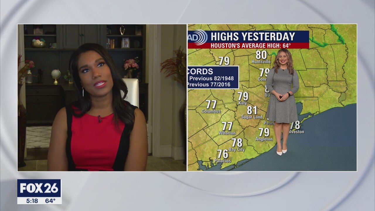
Record highs were reached in Houston and Galveston yesterday and the Island's high of 82 was the all-time December record. More records will be set today with highs in the low to mid 80s. Thursday and Friday afternoon will remain close to record highs, but after a muggy start to New Year's Day morning, a major cool down will move in. The coldest weather of the season is on the way from Saturday night through Monday morning.
Record highs were reached in Houston and Galveston yesterday and the Island's high of 82 was the all-time December record. More records will be set today with highs in the low to mid 80s. Thursday and Friday afternoon will remain close to record highs, but after a muggy start to New Year's Day morning, a major cool down will move in. The coldest weather of the season is on the way from Saturday night through Monday morning.
Wednesday morning weather forecast
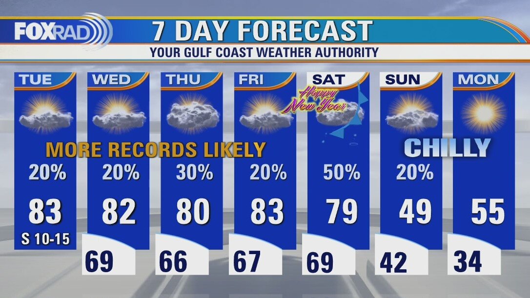
Houston saw record high temperatures on Tuesday afternoon and should expect more on Wednesday. The warm pattern remains in place for Southeast Texas until late Saturday evening when a strong cold front arrives. A brief cold blast will help start the New Year!
Houston saw record high temperatures on Tuesday afternoon and should expect more on Wednesday. The warm pattern remains in place for Southeast Texas until late Saturday evening when a strong cold front arrives. A brief cold blast will help start the New Year!
Tuesday evening weather forecast
Houston saw record high temperatures on Tuesday afternoon and should expect more on Wednesday. The warm pattern remains in place for Southeast Texas until late Saturday evening when a strong cold front arrives. A brief cold blast will help start the New Year!
Houston saw record high temperatures on Tuesday afternoon and should expect more on Wednesday. The warm pattern remains in place for Southeast Texas until late Saturday evening when a strong cold front arrives. A brief cold blast will help start the New Year!
Tuesday weather forecast
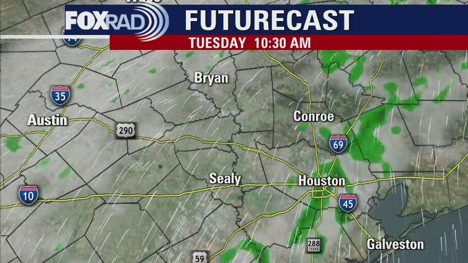
Our streak of record warmth will stay around through Friday as we wrap up what will smash records for the warmest December on record for Houston. Look for highs in the low 80s and lows in the upper 60s along with a few showers. New Years Day will bring showers along a cold front and wintry temperatures will follow. Some areas could have a light freeze by Monday morning.
Our streak of record warmth will stay around through Friday as we wrap up what will smash records for the warmest December on record for Houston. Look for highs in the low 80s and lows in the upper 60s along with a few showers. New Years Day will bring showers along a cold front and wintry temperatures will follow. Some areas could have a light freeze by Monday morning.
Tuesday morning weather forecast
Houston will see a warm end to December with afternoon highs in the lower 80s all week. We will finish the month as the warmest December on record. Southeast Texas will see a brief cold blast as a front arrives in the middle of this upcoming weekend.
Houston will see a warm end to December with afternoon highs in the lower 80s all week. We will finish the month as the warmest December on record. Southeast Texas will see a brief cold blast as a front arrives in the middle of this upcoming weekend.
Monday evening weather forecast
Houston will see a warm end to December with afternoon highs in the lower 80s all week. We will finish the month as the warmest December on record. Southeast Texas will see a brief cold blast as a front arrives in the middle of this upcoming weekend.
Houston will see a warm end to December with afternoon highs in the lower 80s all week. We will finish the month as the warmest December on record. Southeast Texas will see a brief cold blast as a front arrives in the middle of this upcoming weekend.
Monday weather forecast
Our pattern of record warmth will stay in place this week with daily high temperatures in the low 80s and overnight lows in the upper 60s. We will finish this month as the warmest December on record by far. Watch for New Year's Day rain followed by a brief, but intense blast of cold air.
Our pattern of record warmth will stay in place this week with daily high temperatures in the low 80s and overnight lows in the upper 60s. We will finish this month as the warmest December on record by far. Watch for New Year's Day rain followed by a brief, but intense blast of cold air.

Sunday Morning Forecast with Meteorologist Lena Maria
Closing out Christmas Weekend with more warm weather - which looks to continue into our last week of 2021. Partly cloudy skies and highs within a degree of two of 80 will prevail through New Years Day. Some light shower chances starting Tuesday though not much accumulation if any is expected. Breezy out of the south all week, with mild starts in the mid 60s to near 70 degrees also keeps patchy fog chances in the mornings.
Closing out Christmas Weekend with more warm weather - which looks to continue into our last week of 2021. Partly cloudy skies and highs within a degree of two of 80 will prevail through New Years Day. Some light shower chances starting Tuesday though not much accumulation if any is expected. Breezy out of the south all week, with mild starts in the mid 60s to near 70 degrees also keeps patchy fog chances in the mornings.
Christmas Forecast with Meteorologist Lena Maria
Merry Christmas and Happy Hotidays! The warmth will continue throughout the extended period, with highs hovering within a degree or two of 80 and mild morning lows in the upper 60s to near 70 degrees. A bit breezy out of the south through the end of Christmas weekend, mostly sunny and dry through the middle of next week. Rain chances are pretty minimal, but we might see some light showers toward the tail end of the 7 day leading into New Years Eve.
Merry Christmas and Happy Hotidays! The warmth will continue throughout the extended period, with highs hovering within a degree or two of 80 and mild morning lows in the upper 60s to near 70 degrees. A bit breezy out of the south through the end of Christmas weekend, mostly sunny and dry through the middle of next week. Rain chances are pretty minimal, but we might see some light showers toward the tail end of the 7 day leading into New Years Eve.
Thursday night leading into Christmas morning weather forecast
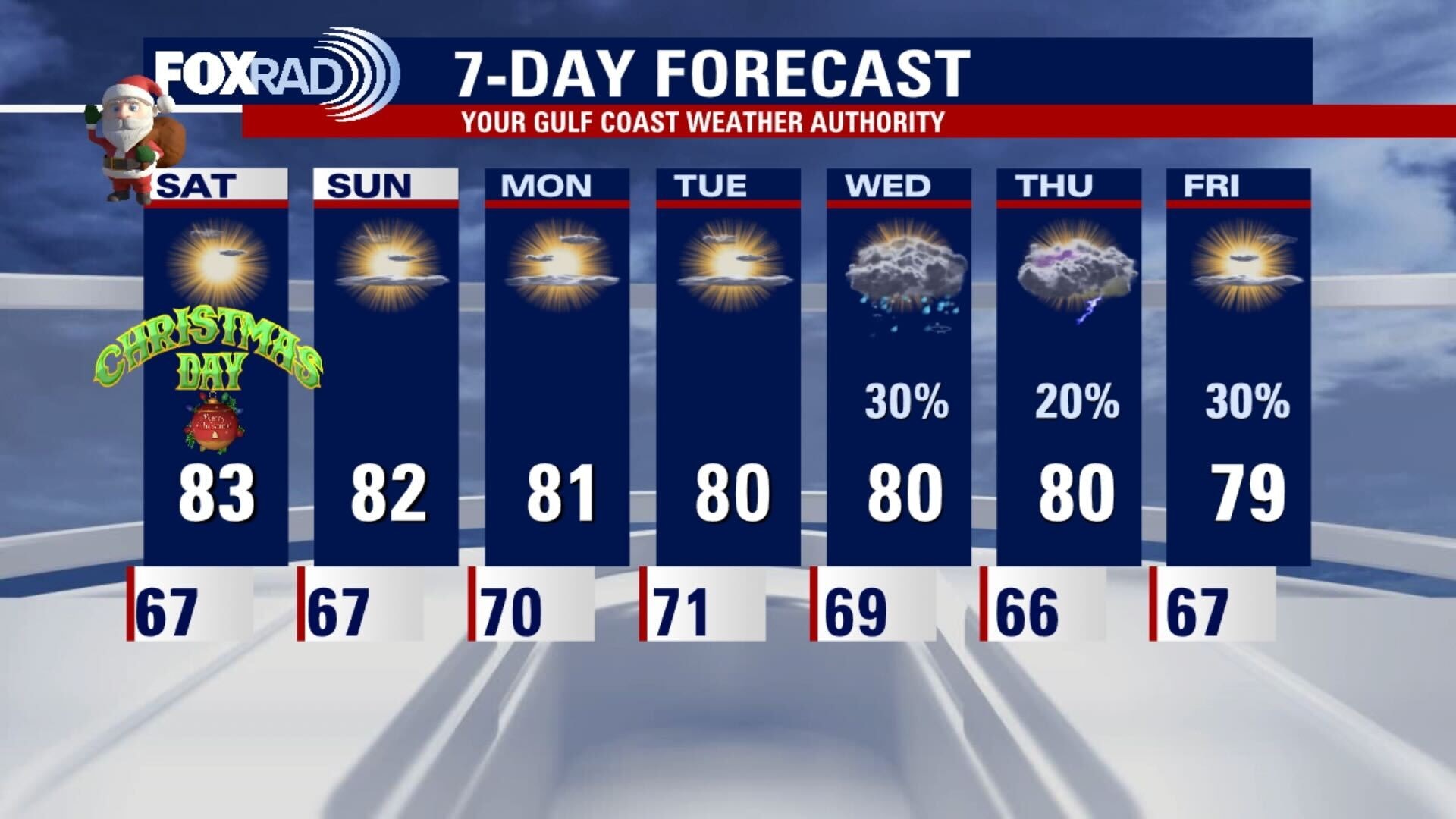
Christmas Day will have highs near record levels and it will remain on the hot side well into the coming week. There may be a few chances for some rain next week, but nothing is looking too steady, so we will have to wait and see.
Christmas Day will have highs near record levels and it will remain on the hot side well into the coming week. There may be a few chances for some rain next week, but nothing is looking too steady, so we will have to wait and see.

Christmas eve weather forecast with Chief Meteorologist Dr. Jim Siebert
Christmas Day will have highs near record levels and it will remain on the hot side well into the coming week. There may be a few chances for some rain next week, but nothing is looking too steady, so we will have to wait and see.
Christmas Day will have highs near record levels and it will remain on the hot side well into the coming week. There may be a few chances for some rain next week, but nothing is looking too steady, so we will have to wait and see.

Warm, sunny & breezy Christmas Eve
Sunny, warm but a bit breezy for Christmas Eve and Christmas Day. It's possible that we stay at, or above 80 for the next seven days in a row. Rain chances aren't looking overly promising over the next week. On Tuesday, a few disturbances may kick some showers our way. Wednesday-Thursday we may see a front, but it also may not make it all the way to us.
Sunny, warm but a bit breezy for Christmas Eve and Christmas Day. It's possible that we stay at, or above 80 for the next seven days in a row. Rain chances aren't looking overly promising over the next week. On Tuesday, a few disturbances may kick some showers our way. Wednesday-Thursday we may see a front, but it also may not make it all the way to us.

Thursday night leading into Christmas Eve morning weather forecast
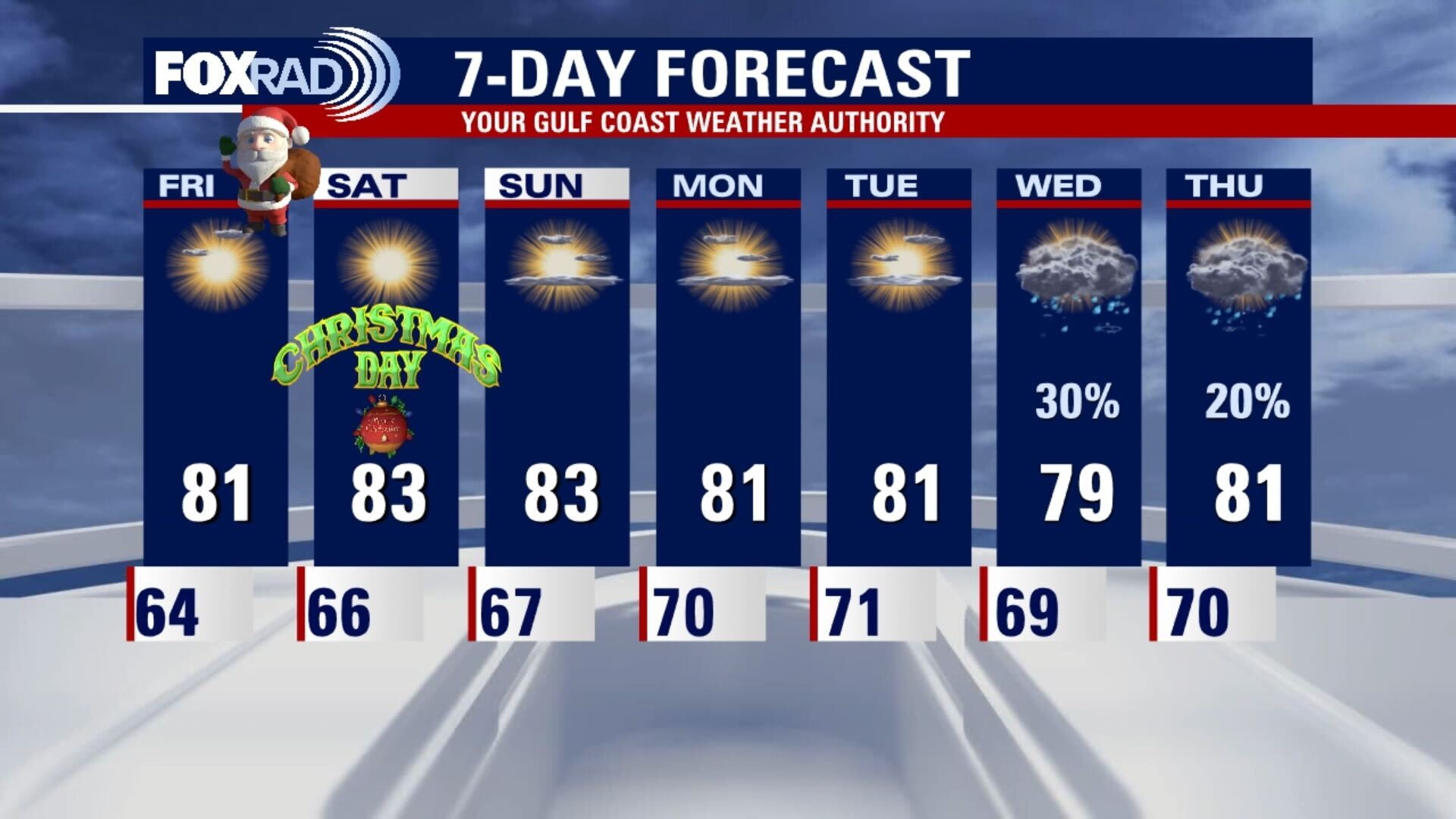
The 80s are back and it looks like a record warm Christmas this year. It remains hot through the weekend and we don't have a chance for any rainfall until the middle of next week. At least we can work on our Christmas tan over the holiday.
The 80s are back and it looks like a record warm Christmas this year. It remains hot through the weekend and we don't have a chance for any rainfall until the middle of next week. At least we can work on our Christmas tan over the holiday.
Thursday evening weather forecast with Chief Meteorologist Dr. Jim Siebert
The 80s are back and it looks like a record warm Christmas this year. It remains hot through the weekend and we don't have a chance for any rainfall until the middle of next week. At least we can work on our Christmas tan over the holiday.
The 80s are back and it looks like a record warm Christmas this year. It remains hot through the weekend and we don't have a chance for any rainfall until the middle of next week. At least we can work on our Christmas tan over the holiday.