

Monday weather forecast
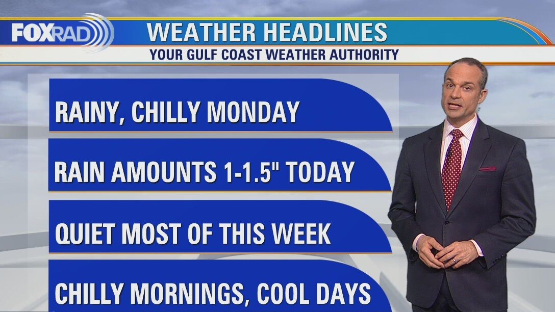
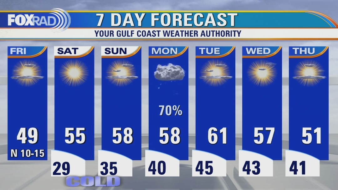
It's going to be a rainy, chilly Monday. Luckily, we aren't expecting widespread heavy rain or extreme cold, but a dreary, wet day near 50 degrees. The rest of the week looks mostly very quiet with chilly nights in the low 40s and cool days in the 50s. There may be another light freeze on Saturday morning.
It's going to be a rainy, chilly Monday. Luckily, we aren't expecting widespread heavy rain or extreme cold, but a dreary, wet day near 50 degrees. The rest of the week looks mostly very quiet with chilly nights in the low 40s and cool days in the 50s. There may be another light freeze on Saturday morning.

Sunday weather forecast with FOX 26 Meteorologist John Dawson
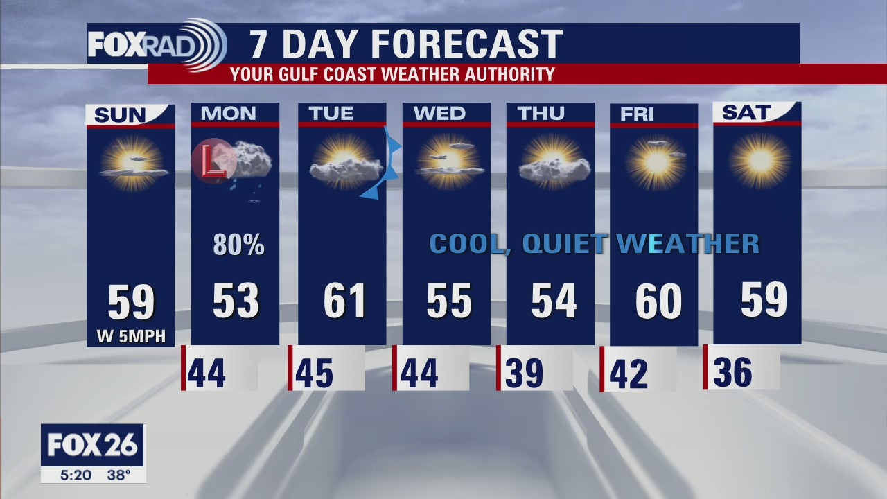
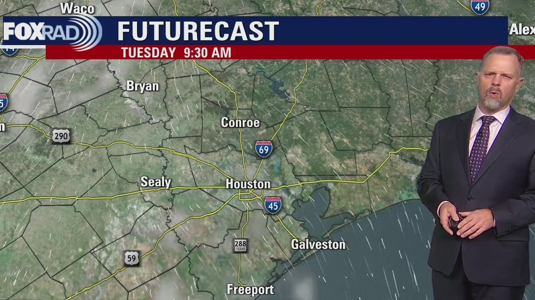
The workweek starts off rainy for Houston. Monday will see showers with isolated thunderstorms across southeast Texas. The rain starts to end late Monday with a dry forecast for the rest of the week. Temperatures remain cool with afternoon highs below the seasonal averages.
The workweek starts off rainy for Houston. Monday will see showers with isolated thunderstorms across southeast Texas. The rain starts to end late Monday with a dry forecast for the rest of the week. Temperatures remain cool with afternoon highs below the seasonal averages.
Sunday Morning Forecast with Meteorologist Lena Maria
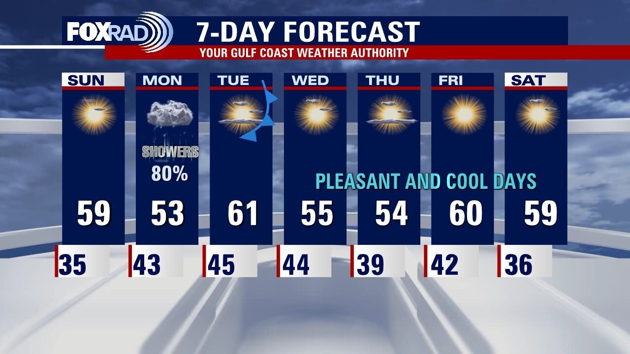
Sunday will be quiet and cool, with increasing cloud cover ahead of our next system. A coastal low will bring rain and isolated thunderstorms to the area throughout the day on Monday, and then we're back to quiet and seasonably cool conditions for the rest of the week.
Sunday will be quiet and cool, with increasing cloud cover ahead of our next system. A coastal low will bring rain and isolated thunderstorms to the area throughout the day on Monday, and then we're back to quiet and seasonably cool conditions for the rest of the week.
Saturday weather forecast with FOX 26 Meteorologist John Dawson
The last week of January is looking pleasant for southeast Texas. Houston will see only one day of rain with lots of cool temperatures for the rest of the week.
The last week of January is looking pleasant for southeast Texas. Houston will see only one day of rain with lots of cool temperatures for the rest of the week.
Saturday Morning Forecast with Meteorologist Lena Maria Arango
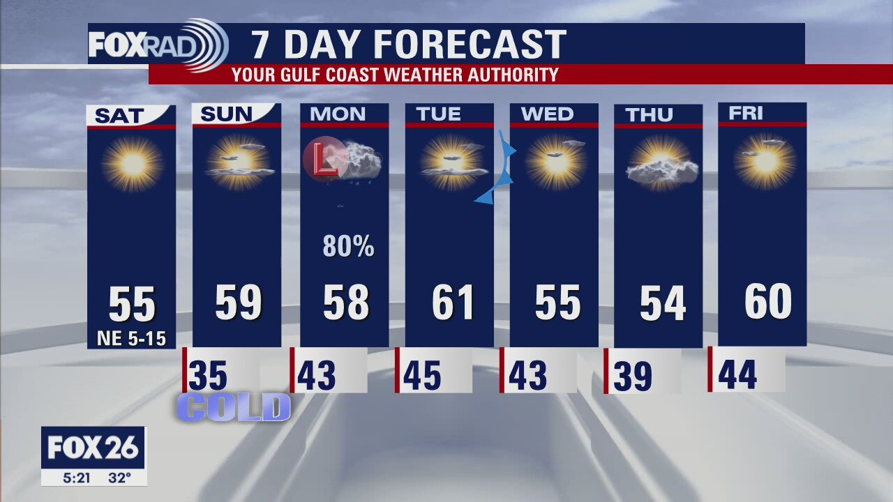
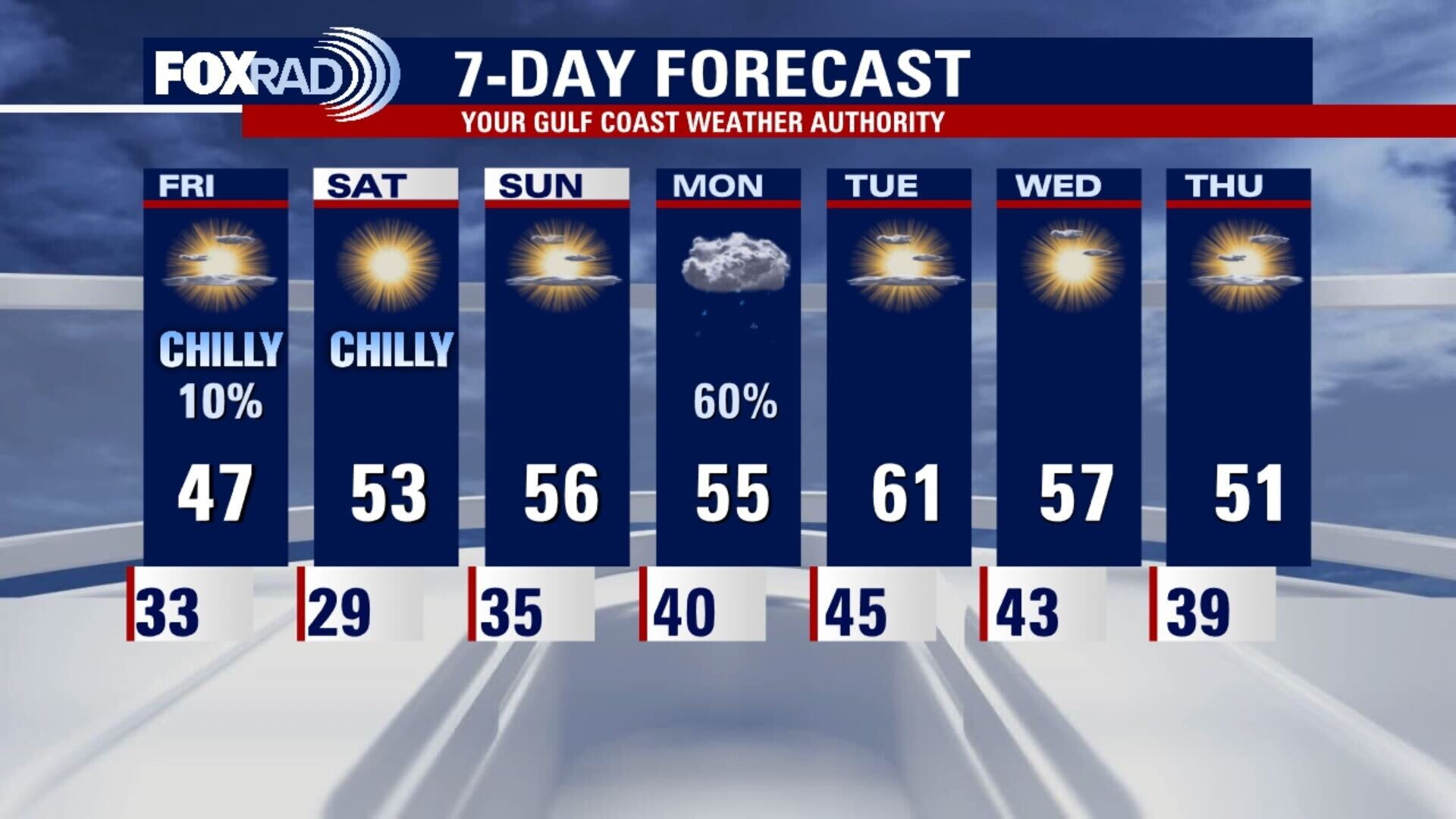
Cold mornings, and cool afternoons will be the trend in southeast Texas over the course of the next week. While we don't have any real warm up to look forward to, the weather will be primarily sunny and dry. A coastal low will lead to a soggy start to the work week, but that is the only day that we are currently expecting rain. A cold front swings through behind the low, bringing a reinforcing shot of cool and dry air.
Cold mornings, and cool afternoons will be the trend in southeast Texas over the course of the next week. While we don't have any real warm up to look forward to, the weather will be primarily sunny and dry. A coastal low will lead to a soggy start to the work week, but that is the only day that we are currently expecting rain. A cold front swings through behind the low, bringing a reinforcing shot of cool and dry air.

Friday leading to Saturday morning weather forecast with Chief Meteorologist Dr. Jim Siebert
A Hard Freeze Warning is posted for several counties just north of the Houston area from 12 a.m. to 8 a.m. Saturday. Lows up there could dip down to 23 degrees. We can expect lows to be just a few degrees warmer, but a freeze is still expected for most of SE Texas
A Hard Freeze Warning is posted for several counties just north of the Houston area from 12 a.m. to 8 a.m. Saturday. Lows up there could dip down to 23 degrees. We can expect lows to be just a few degrees warmer, but a freeze is still expected for most of SE Texas

Friday evening weather forecast with Chief Meteorologist Dr. Jim Siebert
Tonight will be the coldest night of the week with lows in the 20s and 30s. The weekend will be chilly even with a lot of sunshine. Monday will bring showers to the region as an area of low pressure is nearby, but very quiet for the rest of the week after it passes SE Texas.
Tonight will be the coldest night of the week with lows in the 20s and 30s. The weekend will be chilly even with a lot of sunshine. Monday will bring showers to the region as an area of low pressure is nearby, but very quiet for the rest of the week after it passes SE Texas.
Friday weather forecast
Our chance for seeing flurries or light sleet is over and we should see the return of sun this afternoon. It will stay chilly today and tonight, you should expect to be below freezing for several hours. Temps could drop to the mid 20s well north, northwest and northeast of Houston. Saturday and Sunday afternoon look cool, but nice and very dry. Watch for a quick round of rain on Monday.
Our chance for seeing flurries or light sleet is over and we should see the return of sun this afternoon. It will stay chilly today and tonight, you should expect to be below freezing for several hours. Temps could drop to the mid 20s well north, northwest and northeast of Houston. Saturday and Sunday afternoon look cool, but nice and very dry. Watch for a quick round of rain on Monday.
Thursday night leading into Friday morning wintry weather forecast with Chief Meteorologist Dr. Jim Siebert
It will be cold the next few days and into the weekend, and lows will dip below freezing. Most of the precipitation will be gone before our temps go below freezing, but we can expect to see a little sleet across the area this evening. Accumulation is not expected and roads should remain in pretty good condition. Bridges and elevated roads could have some icy patches early Friday morning.
It will be cold the next few days and into the weekend, and lows will dip below freezing. Most of the precipitation will be gone before our temps go below freezing, but we can expect to see a little sleet across the area this evening. Accumulation is not expected and roads should remain in pretty good condition. Bridges and elevated roads could have some icy patches early Friday morning.

Thursday evening wintry weather forecast with Chief Meteorologist Dr. Jim Siebert
It will be cold the next few days and into the weekend, and lows will dip below freezing. Most of the precipitation will be gone before our temps go below freezing, but we can expect to see a little sleet across the area this evening. Accumulation is not expected and roads should remain in pretty good condition. Bridges and elevated roads could have some icy patches early Friday morning.
It will be cold the next few days and into the weekend, and lows will dip below freezing. Most of the precipitation will be gone before our temps go below freezing, but we can expect to see a little sleet across the area this evening. Accumulation is not expected and roads should remain in pretty good condition. Bridges and elevated roads could have some icy patches early Friday morning.
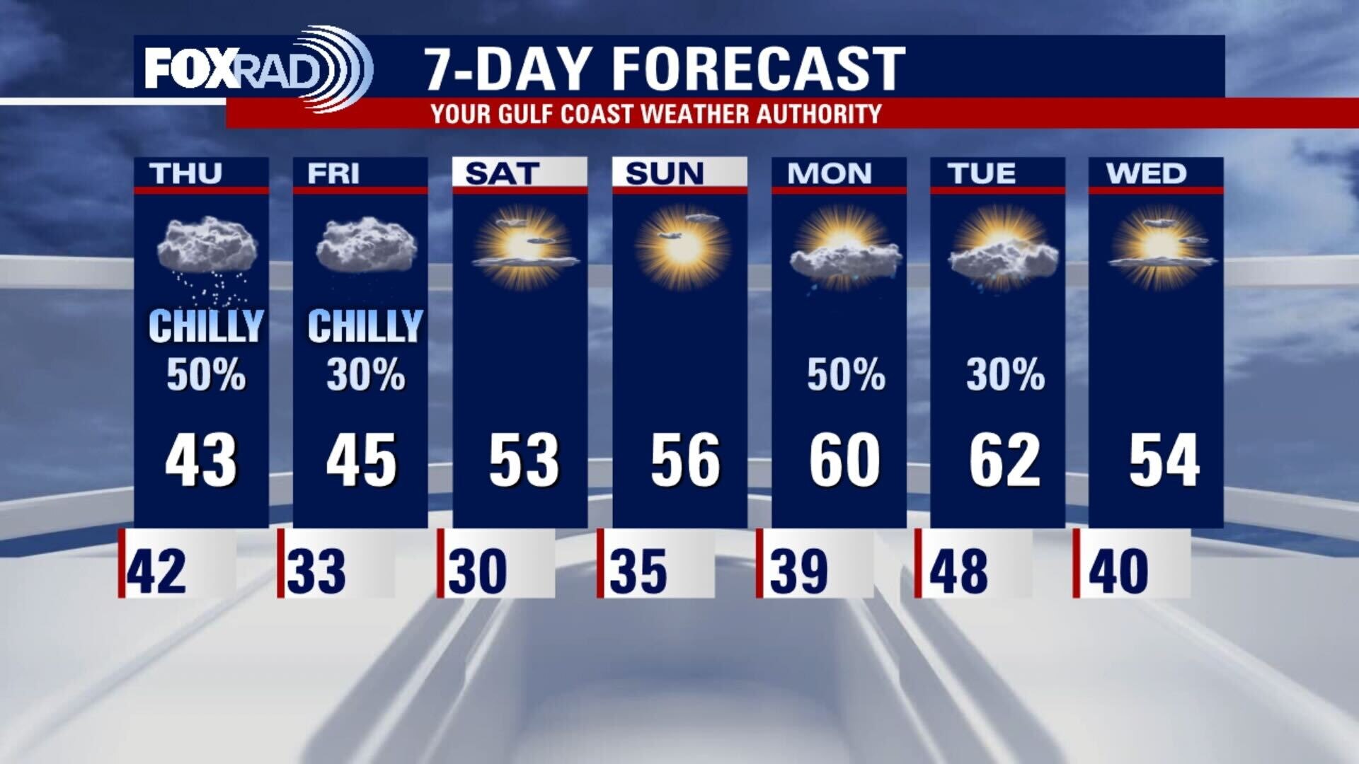
Thursday weather forecast
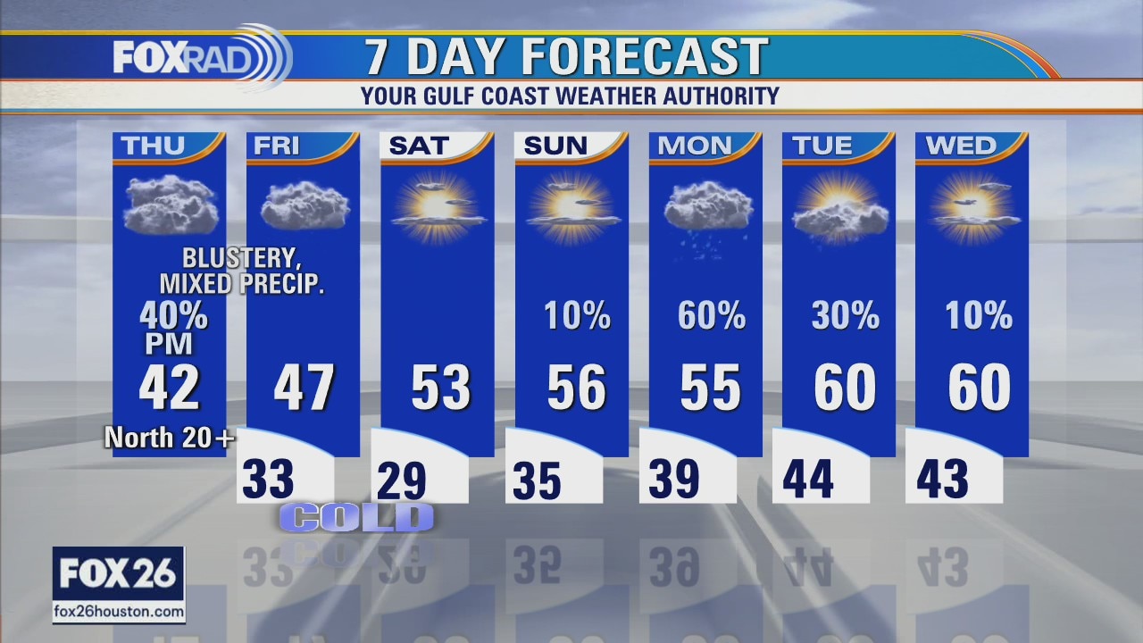
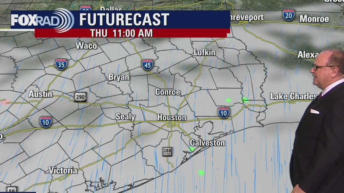
Blustery, dreary conditions will stick around today with temperatures stuck in the upper 30s and low 40s along with harsh north winds. Cold drizzle along with possible light sleet pellets are expected by the afternoon and evening. Patches of ice are possible overnight, but they aren't likely to be widespread. A hard freeze is likely Friday night into Saturday morning.
Blustery, dreary conditions will stick around today with temperatures stuck in the upper 30s and low 40s along with harsh north winds. Cold drizzle along with possible light sleet pellets are expected by the afternoon and evening. Patches of ice are possible overnight, but they aren't likely to be widespread. A hard freeze is likely Friday night into Saturday morning.
Thursday morning weather forecast
Thursday and Friday will have a chance for some wintry mix of frozen precipitation. Look for possible icy conditions on area bridges or elevated roads.
Thursday and Friday will have a chance for some wintry mix of frozen precipitation. Look for possible icy conditions on area bridges or elevated roads.
Wednesday evening weather forecast with Chief Meteorologist Dr. Jim Siebert
There's a risk for strong to severe storms for Wednesday night as a strong front arrives, but Thursday and Friday will have a chance for some wintry mix of frozen precipitation. Look for possible icy conditions on area bridges or elevated roads.
There's a risk for strong to severe storms for Wednesday night as a strong front arrives, but Thursday and Friday will have a chance for some wintry mix of frozen precipitation. Look for possible icy conditions on area bridges or elevated roads.
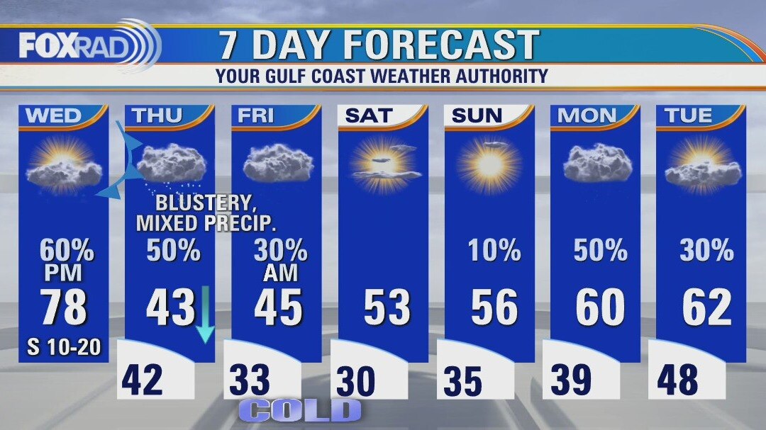
Wednesday weather forecast
The next 48 hours will bring some extreme changes in our temperatures and give us a chance for areas of sleet or light snow. Today will be warm with scattered afternoon and evening storms, some of which could be strong. There is a slight chance for isolated tornadoes. Tonight, temperatures plunge as blustery north winds kick in and tomorrow conditions could allow for cold rain, some sleet (ice pellets) and even some snow, but it is not likely to accumulate.
The next 48 hours will bring some extreme changes in our temperatures and give us a chance for areas of sleet or light snow. Today will be warm with scattered afternoon and evening storms, some of which could be strong. There is a slight chance for isolated tornadoes. Tonight, temperatures plunge as blustery north winds kick in and tomorrow conditions could allow for cold rain, some sleet (ice pellets) and even some snow, but it is not likely to accumulate.
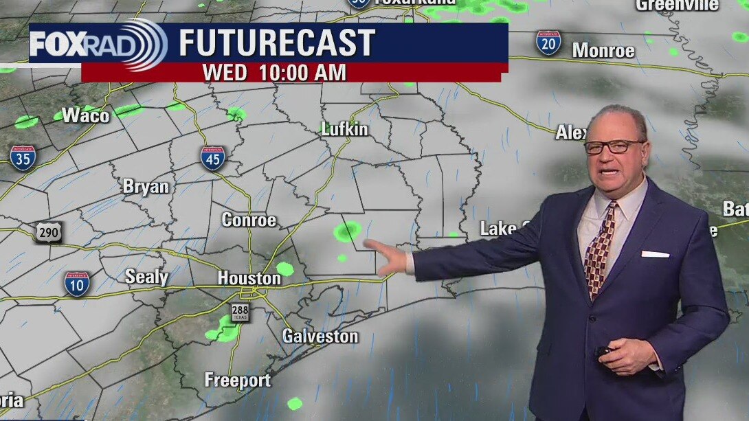
Wednesday morning weather forecast
A front arrives later on Wed. and there may be a few strong storms in the evening. It will be cold on Thur. and Fri. plus there could be a wintry mix of rain, sleet, and even snow Thur. night into early Fri. It will be cold into the weekend.
A front arrives later on Wed. and there may be a few strong storms in the evening. It will be cold on Thur. and Fri. plus there could be a wintry mix of rain, sleet, and even snow Thur. night into early Fri. It will be cold into the weekend.
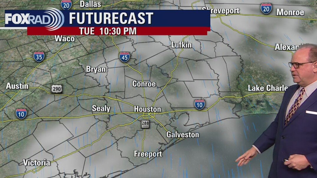
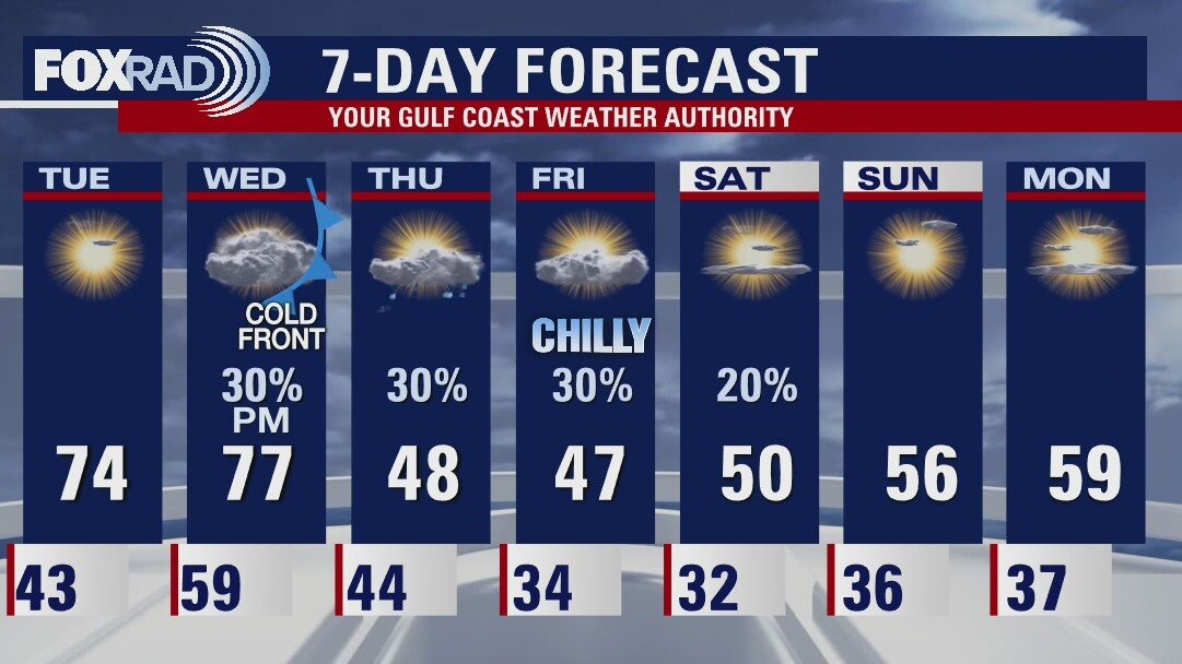
Tuesday evening weather forecast
A front arrives later on Wed. and there may be a few strong storms in the evening. It will be cold on Thur. and Fri. plus there could be a wintry mix of rain, sleet and even snow Thur. night into early Fri. It will be cold into the weekend.
A front arrives later on Wed. and there may be a few strong storms in the evening. It will be cold on Thur. and Fri. plus there could be a wintry mix of rain, sleet and even snow Thur. night into early Fri. It will be cold into the weekend.
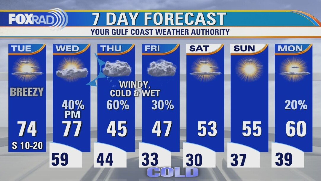
Tuesday weather forecast
Spring-like afternoon temperatures are on the way today and tomorrow, but a major cold front will arrive late Wednesday bringing a round of storms. Blustery, wet conditions will move in Thursday and there is a brief chance for sleet or some light snow Thursday night and Friday morning. Wintry precipitation is not likely to "stick", but we will monitor for any icy spots.
Spring-like afternoon temperatures are on the way today and tomorrow, but a major cold front will arrive late Wednesday bringing a round of storms. Blustery, wet conditions will move in Thursday and there is a brief chance for sleet or some light snow Thursday night and Friday morning. Wintry precipitation is not likely to "stick", but we will monitor for any icy spots.
Tuesday morning weather forecast
Houston will see mild January weather for the next couple of days. A cold front late Wednesday will put the chill back in the air. Thursday and Friday could see a few showers across Southeast Texas and perhaps even a little sleet or brief snow flakes for the northern counties. Accumulation is not expected.
Houston will see mild January weather for the next couple of days. A cold front late Wednesday will put the chill back in the air. Thursday and Friday could see a few showers across Southeast Texas and perhaps even a little sleet or brief snow flakes for the northern counties. Accumulation is not expected.
Monday evening weather forecast
Houston will see mild January weather for the next couple of days. A cold front late Wednesday will put the chill back in the air. Thursday and Friday could see a few showers across Southeast Texas and perhaps even a little sleet or brief snow flakes for the northern counties. Accumulation is not expected.
Houston will see mild January weather for the next couple of days. A cold front late Wednesday will put the chill back in the air. Thursday and Friday could see a few showers across Southeast Texas and perhaps even a little sleet or brief snow flakes for the northern counties. Accumulation is not expected.
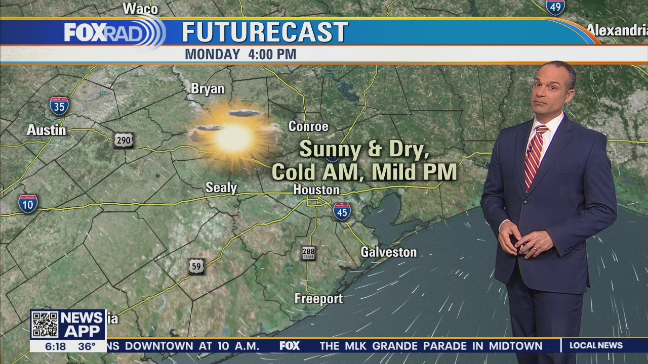
Sunshine, dry air and highs in the mid-60s
Following a frosty start to the Martin Luther King Day holiday, expect sunshine, dry air with highs in the mid-60s. We'll enjoy two spring-like afternoons on Tuesday and Wednesday before a late-day cold front on Wednesday evening. We're looking for three days of cold and unsettled weather with a chance for some sleet or freezing rain, especially north of Houston.
Following a frosty start to the Martin Luther King Day holiday, expect sunshine, dry air with highs in the mid-60s. We'll enjoy two spring-like afternoons on Tuesday and Wednesday before a late-day cold front on Wednesday evening. We're looking for three days of cold and unsettled weather with a chance for some sleet or freezing rain, especially north of Houston.