

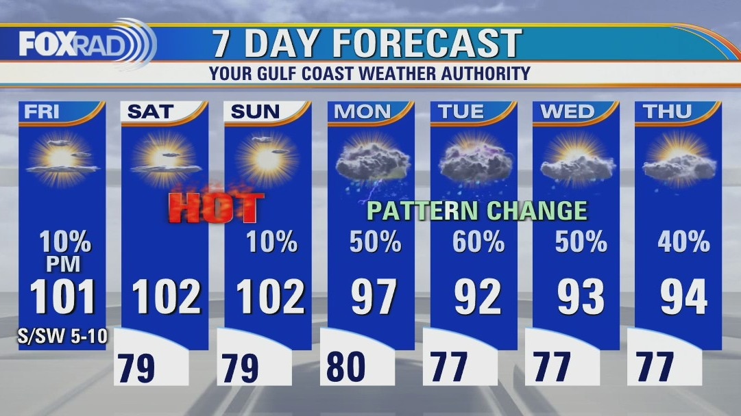
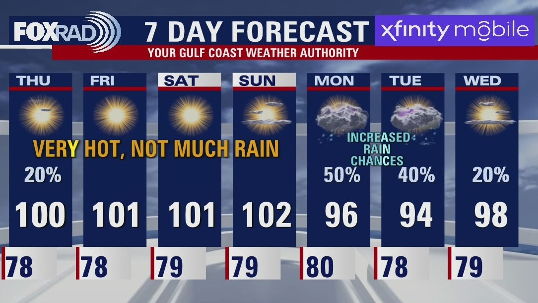
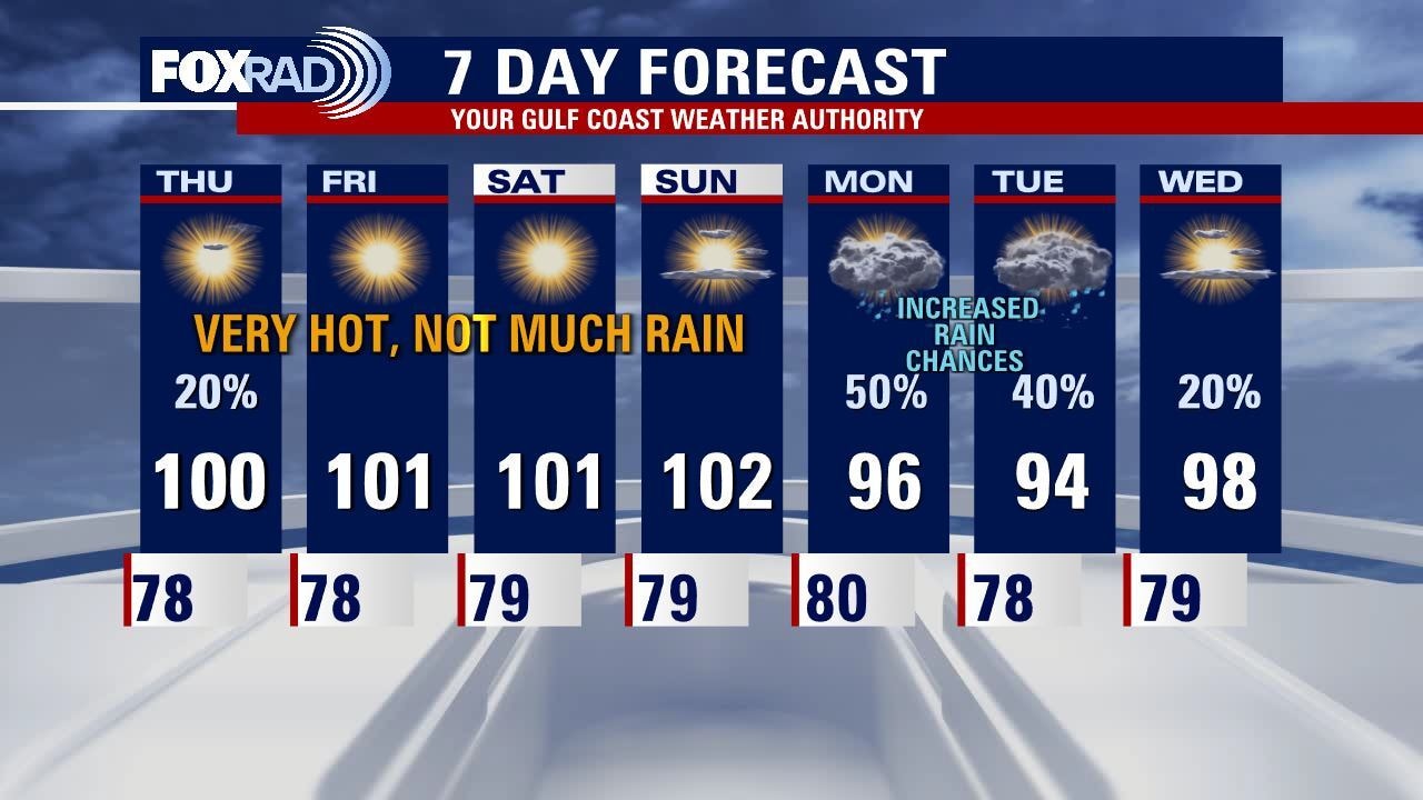
Sunny and hot Friday with highs near 100 and a slight chance for a storm
Strong sunshine, light breezes and near-record high temperatures will remain in place through Sunday, so expect a very hot weekend. Monday looks hot as well, but there is a good chance for storms by the afternoon. Clouds and showers are much more likely along a stalled front for much of next week, so finally we could feel about a 7-10? drop in high temperatures along with much needed rain.
Strong sunshine, light breezes and near-record high temperatures will remain in place through Sunday, so expect a very hot weekend. Monday looks hot as well, but there is a good chance for storms by the afternoon. Clouds and showers are much more likely along a stalled front for much of next week, so finally we could feel about a 7-10? drop in high temperatures along with much needed rain.
Friday morning weather forecast
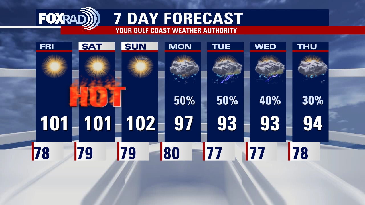
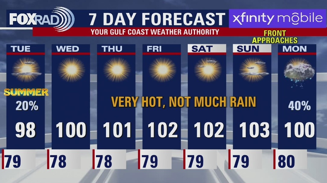
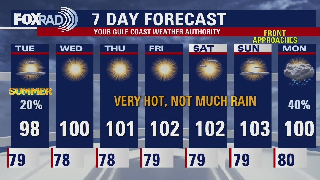
Blazing sunshine and triple digit heat continues tomorrow and into the weekend. Highs will approach record territory with heat index values soaring above 105. Much needed rain is scheduled to arrive Monday with a cold front pushing into Southeast Texas. Not only will the front provide beneficial moisture, but also some heat relief is in sight!
Blazing sunshine and triple digit heat continues tomorrow and into the weekend. Highs will approach record territory with heat index values soaring above 105. Much needed rain is scheduled to arrive Monday with a cold front pushing into Southeast Texas. Not only will the front provide beneficial moisture, but also some heat relief is in sight!
Friday evening weather forecast with Meteorologist Adrienne Vonn
Blazing sunshine and triple digit heat continues tomorrow and into the weekend. Highs will approach record territory with heat index values soaring above 105. Much-needed rain is scheduled to arrive Monday with a cold front pushing into Southeast Texas. Not only will the front provide beneficial moisture, but also some heat relief is in sight!
Blazing sunshine and triple digit heat continues tomorrow and into the weekend. Highs will approach record territory with heat index values soaring above 105. Much-needed rain is scheduled to arrive Monday with a cold front pushing into Southeast Texas. Not only will the front provide beneficial moisture, but also some heat relief is in sight!
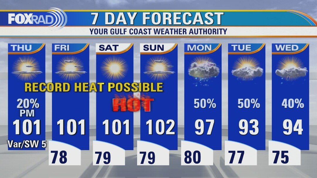
Hot and humid Thursday with a slight chance for a late day storm
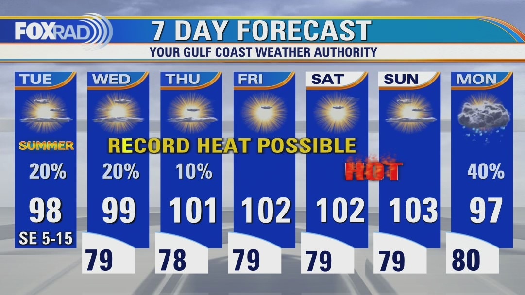
Get ready for a hot stretch over the next four days (yes, hotter than the past few days) with light winds, lots of sun and highs north of 100 very likely through Sunday. There will probably be a few storms late this afternoon into the early evening and even a strong one is possible, but otherwise, the story is high heat. Advisories could be issued at some point over the next few days, but we are just below heat advisory criteria today.
Get ready for a hot stretch over the next four days (yes, hotter than the past few days) with light winds, lots of sun and highs north of 100 very likely through Sunday. There will probably be a few storms late this afternoon into the early evening and even a strong one is possible, but otherwise, the story is high heat. Advisories could be issued at some point over the next few days, but we are just below heat advisory criteria today.
Thursday morning weather forecast
Houston may see an isolated shower on Thursday, but don't count on much rain around Southeast Texas until Monday. A summer cold front will break the hot and dry pattern. At least for a couple days.
Houston may see an isolated shower on Thursday, but don't count on much rain around Southeast Texas until Monday. A summer cold front will break the hot and dry pattern. At least for a couple days.
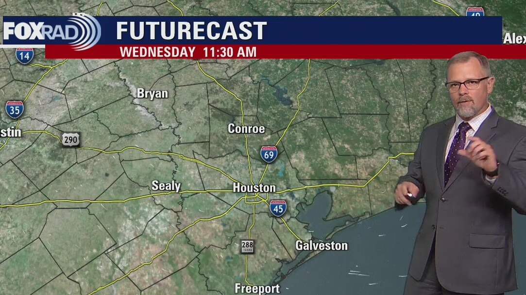
Wednesday evening weather forecast with Meteorologist John Dawson
Houston may see an isolated shower on Thursday, but don't count on much rain around Southeast Texas until Monday. A summer cold front will break the hot and dry pattern. At least for a couple days.
Houston may see an isolated shower on Thursday, but don't count on much rain around Southeast Texas until Monday. A summer cold front will break the hot and dry pattern. At least for a couple days.
Sizzling summer is here
Rain chances remain fairly minimal today and tomorrow, with temperatures in the upper 90s to near 100. The first weekend of summer looks to be sizzling hot before a summer cool front brings us the most hopeful opportunity of more widespread rain that we've seen in a while. We're still several days out, so stay tuned for changes but plan for showers and storms as early as Sunday night through possibly the middle of next week with at least a slight decrease in temperatures so some drought/heat relief is on the way.
Rain chances remain fairly minimal today and tomorrow, with temperatures in the upper 90s to near 100. The first weekend of summer looks to be sizzling hot before a summer cool front brings us the most hopeful opportunity of more widespread rain that we've seen in a while. We're still several days out, so stay tuned for changes but plan for showers and storms as early as Sunday night through possibly the middle of next week with at least a slight decrease in temperatures so some drought/heat relief is on the way.
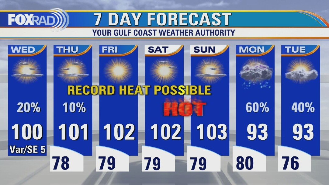
Hot and humid Wednesday, with some showers and storms possible
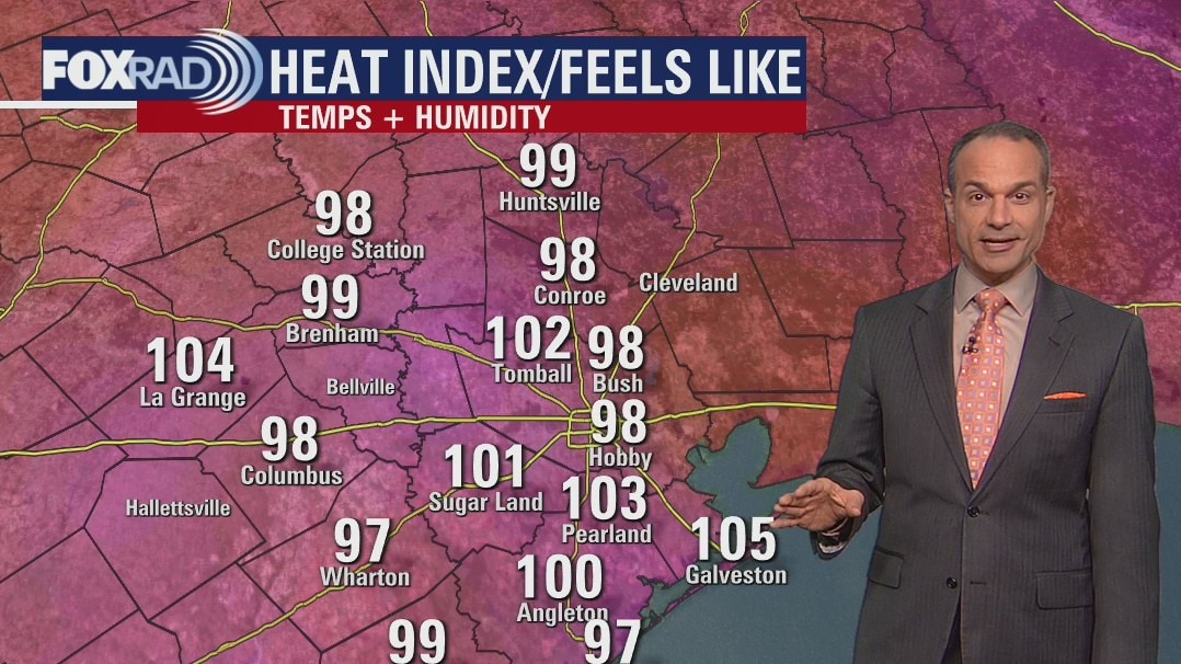
The good news is that once again, there will be some widely scattered showers and a few storms today and tomorrow. The not so great news is that high temperatures will still approach 100 and even hotter weather is on the way. The hottest weather of the year is expected for Friday and the weekend with records possible and heat advisories likely. Both the GFS and Euro model are now giving us more confidence in clouds and rain returning on Monday which should allow for some relief to the heat wave.
The good news is that once again, there will be some widely scattered showers and a few storms today and tomorrow. The not so great news is that high temperatures will still approach 100 and even hotter weather is on the way. The hottest weather of the year is expected for Friday and the weekend with records possible and heat advisories likely. Both the GFS and Euro model are now giving us more confidence in clouds and rain returning on Monday which should allow for some relief to the heat wave.
Wednesday morning weather forecast
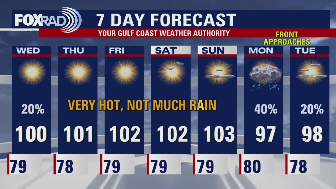
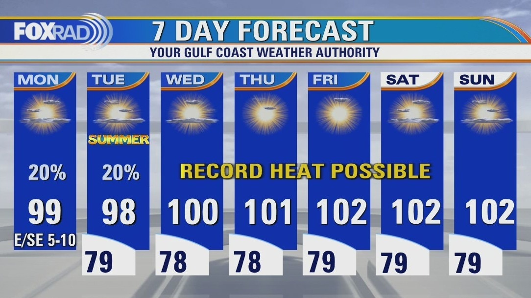
Triple digits return to the forecast on Wednesday and will stay there until the end of the weekend. Houston could see more record high temperatures during this stretch. Heat Advisories may also have to be issued at some point. The lack of rain also continues in the forecast until Monday when a summer cold front should break the hot and dry pattern.
Triple digits return to the forecast on Wednesday and will stay there until the end of the weekend. Houston could see more record high temperatures during this stretch. Heat Advisories may also have to be issued at some point. The lack of rain also continues in the forecast until Monday when a summer cold front should break the hot and dry pattern.
Tuesday evening weather forecast
Triple digits return to the forecast on Wednesday and will stay there until the end of the weekend. Houston could see more record high temperatures during this stretch. Heat Advisories may also have to be issued at some point. The lack of rain also continues in the forecast until Monday when a summer cold front should break the hot and dry pattern.
Triple digits return to the forecast on Wednesday and will stay there until the end of the weekend. Houston could see more record high temperatures during this stretch. Heat Advisories may also have to be issued at some point. The lack of rain also continues in the forecast until Monday when a summer cold front should break the hot and dry pattern.
Heat index continues to be hot and humid
After the hottest day since August of 2020 yesterday, today is hot again, but just 2-3 degrees less hot. There will be a few widely scattered showers and a few storms possible, but a muggy southeast breeze will keep the weather very warm and humid. The rest of the week will continue our long heat wave and the hottest temps should arrive this weekend ahead of a summer front. Some helpful showers are expected on Monday.
After the hottest day since August of 2020 yesterday, today is hot again, but just 2-3 degrees less hot. There will be a few widely scattered showers and a few storms possible, but a muggy southeast breeze will keep the weather very warm and humid. The rest of the week will continue our long heat wave and the hottest temps should arrive this weekend ahead of a summer front. Some helpful showers are expected on Monday.
Mostly sunny Tuesday, hot and breezy with isolated afternoon storms
After the hottest day since August 2020 yesterday, today will certainly be hot again, but likely 2-3 degrees less hot. There will be a few widely sct'd showers and a few storms possible, but a muggy southeast breeze will keep the weather very warm and humid. The rest of the week will continue our long heat wave and the hottest temps should arrive this weekend ahead of a summer front. Some helpful showers are expected on Monday.
After the hottest day since August 2020 yesterday, today will certainly be hot again, but likely 2-3 degrees less hot. There will be a few widely sct'd showers and a few storms possible, but a muggy southeast breeze will keep the weather very warm and humid. The rest of the week will continue our long heat wave and the hottest temps should arrive this weekend ahead of a summer front. Some helpful showers are expected on Monday.
Tuesday morning weather forecast
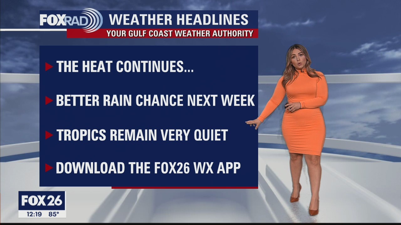
Summer in southeast Texas will begin with a stretch of scorching hot temperatures. A strong ridge of high pressure is going to keep us firmly parked at or above 100 degrees for most of this week. But it's not ALL doom and gloom. A front looks to bring us showers and storms in about a week from now. I wouldn't get too excited about any type of a decrease in temperatures... although we will all welcome some widespread rainfall given the drought situation. Until then, please keep heat and sun safety in mind and abide by burn bans which are in effect in many counties. Tropics remain quiet too so just plan for lots of hot sunshine, and warm humid overnights locally.
Summer in southeast Texas will begin with a stretch of scorching hot temperatures. A strong ridge of high pressure is going to keep us firmly parked at or above 100 degrees for most of this week. But it's not ALL doom and gloom. A front looks to bring us showers and storms in about a week from now. I wouldn't get too excited about any type of a decrease in temperatures... although we will all welcome some widespread rainfall given the drought situation. Until then, please keep heat and sun safety in mind and abide by burn bans which are in effect in many counties. Tropics remain quiet too so just plan for lots of hot sunshine, and warm humid overnights locally.
Monday evening weather forecast
Summer in southeast Texas will begin with a stretch of scorching hot temperatures. A strong ridge of high pressure is going to keep us firmly parked at or above 100 degrees for most of this week. But it's not ALL doom and gloom. A front looks to bring us showers and storms in about a week from now. I wouldn't get too excited about any type of a decrease in temperatures... although we will all welcome some widespread rainfall given the drought situation. Until then, please keep heat and sun safety in mind and abide by burn bans which are in effect in many counties. Tropics remain quiet too so just plan for lots of hot sunshine, and warm humid overnights locally.
Summer in southeast Texas will begin with a stretch of scorching hot temperatures. A strong ridge of high pressure is going to keep us firmly parked at or above 100 degrees for most of this week. But it's not ALL doom and gloom. A front looks to bring us showers and storms in about a week from now. I wouldn't get too excited about any type of a decrease in temperatures... although we will all welcome some widespread rainfall given the drought situation. Until then, please keep heat and sun safety in mind and abide by burn bans which are in effect in many counties. Tropics remain quiet too so just plan for lots of hot sunshine, and warm humid overnights locally.
It just keeps getting hotter
We've had 15 consecutive days with above-average temperatures and that trend will not only continue, but intensify. Look for a few isolated thunderstorms today and Tuesday with otherwise hot conditions. Higher pressure builds in beginning Wednesday and will get stronger through the weekend. Record high will be possible with daily highs likely above 100. Our drought is very likely to become much more severe this week and 10 counties in our area, including Galveston County, already have declared burn bans.
We've had 15 consecutive days with above-average temperatures and that trend will not only continue, but intensify. Look for a few isolated thunderstorms today and Tuesday with otherwise hot conditions. Higher pressure builds in beginning Wednesday and will get stronger through the weekend. Record high will be possible with daily highs likely above 100. Our drought is very likely to become much more severe this week and 10 counties in our area, including Galveston County, already have declared burn bans.
Hot Monday with isolated late day storms possible
We've had 15 consecutive days with above average temperatures and that trend will not only continue, but will intensify. Look for a few isolated thunderstorms today and Tuesday with otherwise hot conditions. Higher pressure builds in beginning Wednesday and getting stronger through the weekend. Record high will be possible with daily highs likely above 100. Out drought is very likely to become much more severe this week and 10 counties in our area, including Galveston County, already have declared burn bans.
We've had 15 consecutive days with above average temperatures and that trend will not only continue, but will intensify. Look for a few isolated thunderstorms today and Tuesday with otherwise hot conditions. Higher pressure builds in beginning Wednesday and getting stronger through the weekend. Record high will be possible with daily highs likely above 100. Out drought is very likely to become much more severe this week and 10 counties in our area, including Galveston County, already have declared burn bans.
Sunday Morning Forecast with Meteorologist Lena Maria Arango
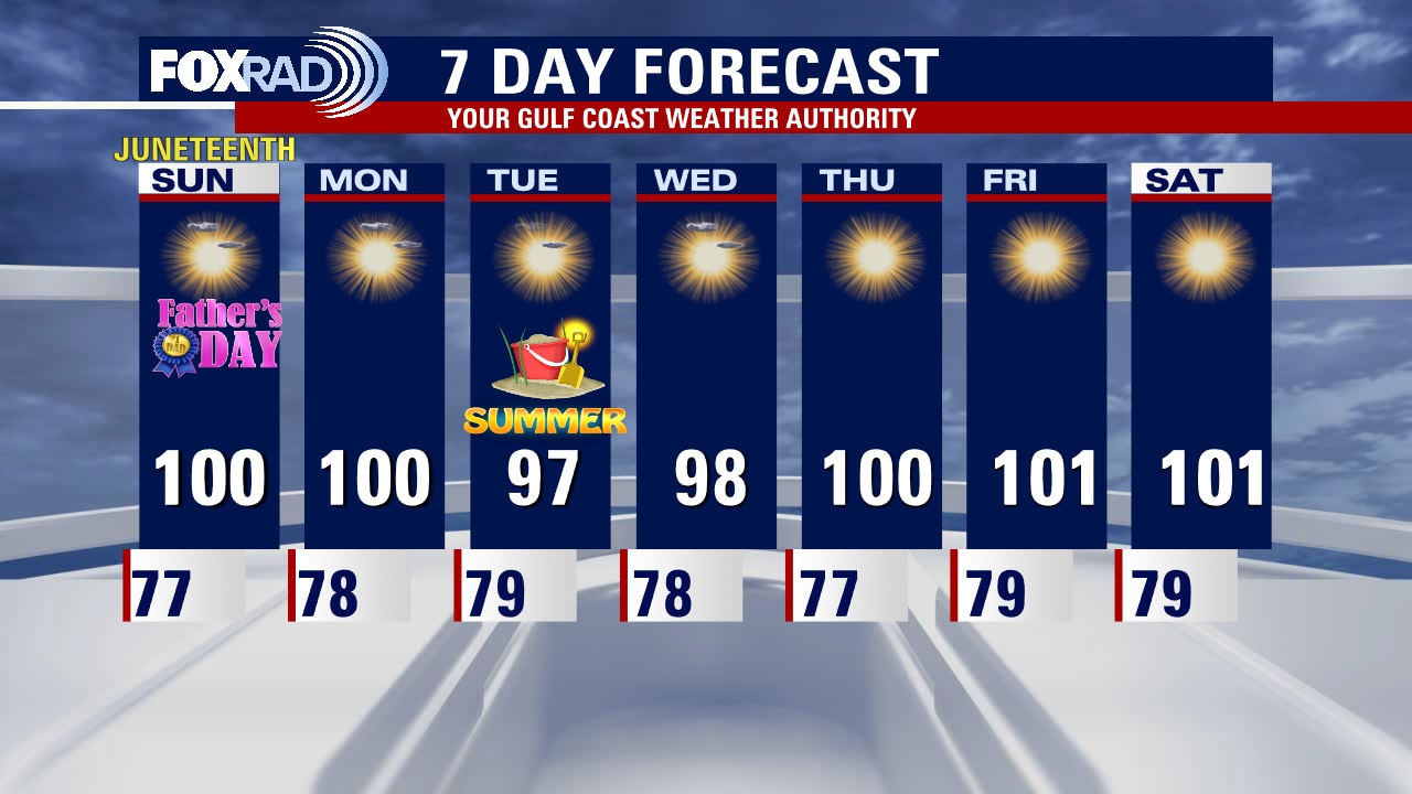
The heat is on for Father's Day and Juneteenth outdoor celebrations, and it's sticking with us throughout the course of the week. Rain chances remain minimal, but a select lucky few will see something over the course of the next few days. Summer starts on Tuesday, and the first weekend of Summer is gonna be a scorcher. Be sure to keep heat and sun safety in mind, in addition to water conservation as the drought will likely continue to worsen this week.
The heat is on for Father's Day and Juneteenth outdoor celebrations, and it's sticking with us throughout the course of the week. Rain chances remain minimal, but a select lucky few will see something over the course of the next few days. Summer starts on Tuesday, and the first weekend of Summer is gonna be a scorcher. Be sure to keep heat and sun safety in mind, in addition to water conservation as the drought will likely continue to worsen this week.
Saturday night leading into Sunday morning weather forecast
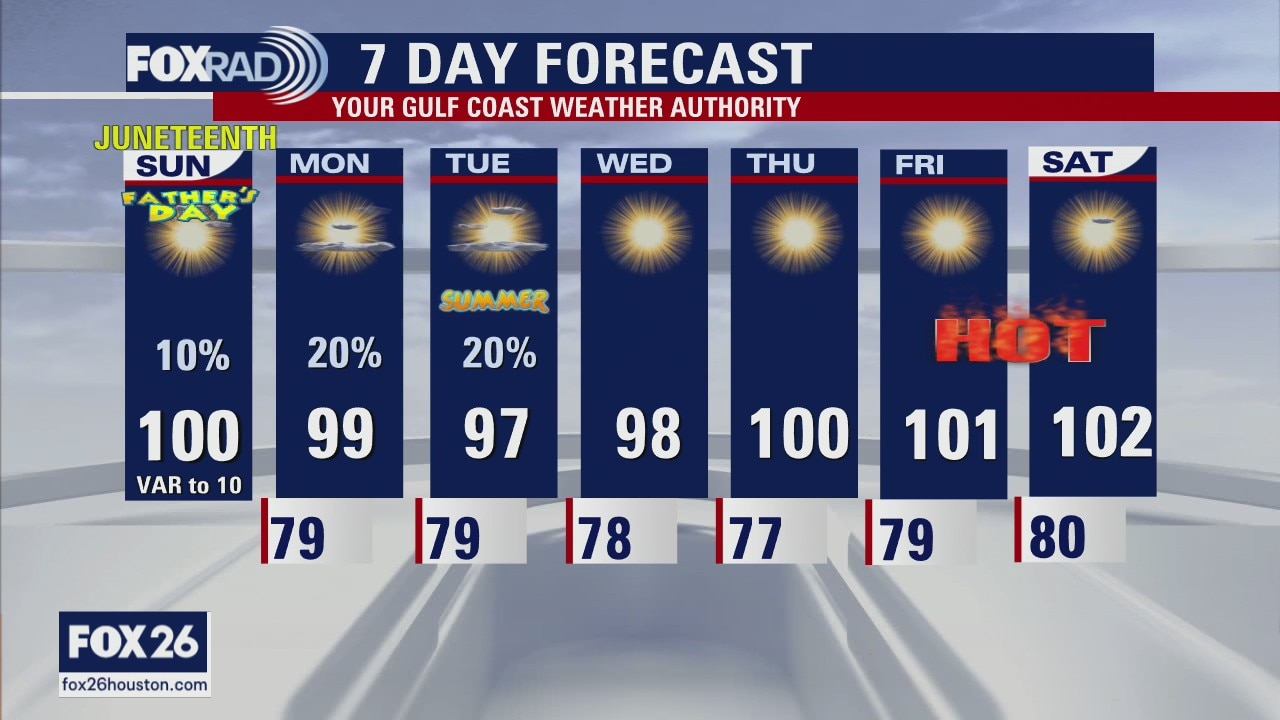
Sizzling sunshine is in sight for the second half of the weekend. If you have any outdoor plans for Father's Day or Juneteenth, make sure you are taking heat safety precautions, as high temperatures will soar to near 100. More heat is on deck next week, with highs reaching the upper 90s to 100. Be safe & stay cool everyone!
Sizzling sunshine is in sight for the second half of the weekend. If you have any outdoor plans for Father's Day or Juneteenth, make sure you are taking heat safety precautions, as high temperatures will soar to near 100. More heat is on deck next week, with highs reaching the upper 90s to 100. Be safe & stay cool everyone!
Saturday Morning Forecast with Meteorologist Lena Maria Arango
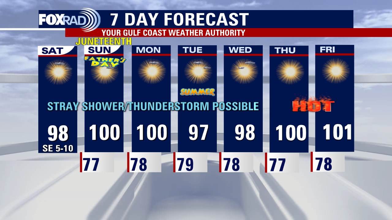
Meteorologist Mike Iscovitz has officially been named the Chief Meteorologist of Your Gulf Coast Weather Authority, congrats Mike! The tropics are quiet at the moment but there is plenty of heat to monitor, with several days likely hitting triple digits. Aside from the hot sunshine, we'll be dry with rain chances remaining at about 10% or less on the day to day. Try to take advantage of the cooler parts of the day (early, late) to get outside, celebrate Dad/Juneteenth and exercise for yourself/pets. Unfortunately, drought and heat relief is not on the horizon in the near future.
Meteorologist Mike Iscovitz has officially been named the Chief Meteorologist of Your Gulf Coast Weather Authority, congrats Mike! The tropics are quiet at the moment but there is plenty of heat to monitor, with several days likely hitting triple digits. Aside from the hot sunshine, we'll be dry with rain chances remaining at about 10% or less on the day to day. Try to take advantage of the cooler parts of the day (early, late) to get outside, celebrate Dad/Juneteenth and exercise for yourself/pets. Unfortunately, drought and heat relief is not on the horizon in the near future.