


Friday afternoon weather forecast with Meteorologist Lena Maria
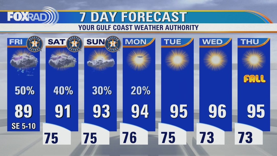
Scattered showers & storms look to peak today, and then decline as we work our way through the weekend. Outdoor plans need not be canceled but may have to be paused from time to time. Stay weather aware & navigate the action using our free FOX26 Weather App. Then, get ready for a big-time warmup as we head into next week. Fiona rides a little farther south, which bears a bit closer watching long-term. Remnants of Merbok set to bring major impacts to western Alaska through the weekend.
Scattered showers & storms look to peak today, and then decline as we work our way through the weekend. Outdoor plans need not be canceled but may have to be paused from time to time. Stay weather aware & navigate the action using our free FOX26 Weather App. Then, get ready for a big-time warmup as we head into next week. Fiona rides a little farther south, which bears a bit closer watching long-term. Remnants of Merbok set to bring major impacts to western Alaska through the weekend.
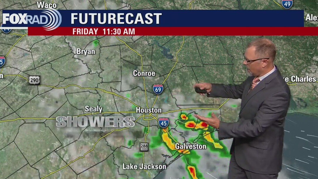
Scattered shower/storm chances increase from south to north Friday
Scattered showers & storms look to peak today, and then decline as we work our way through the weekend. Outdoor plans need not be canceled, but may have to be paused from time to time. Stay weather aware and navigate the action using our free FOX 26 Weather App. Then, get ready for a big time warmup as we head into next week. Fiona riding a little farther south, which bears a bit closer watching long-term. Remnants of Merbok set to bring major impacts to western Alaska through the weekend
Scattered showers & storms look to peak today, and then decline as we work our way through the weekend. Outdoor plans need not be canceled, but may have to be paused from time to time. Stay weather aware and navigate the action using our free FOX 26 Weather App. Then, get ready for a big time warmup as we head into next week. Fiona riding a little farther south, which bears a bit closer watching long-term. Remnants of Merbok set to bring major impacts to western Alaska through the weekend
Friday morning weather forecast
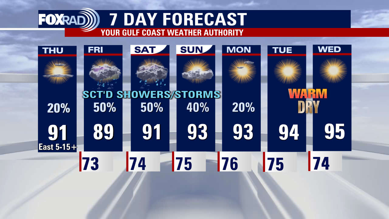
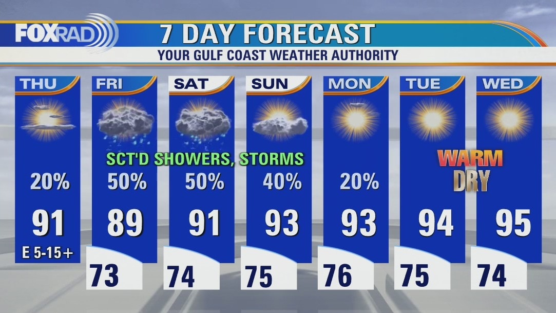
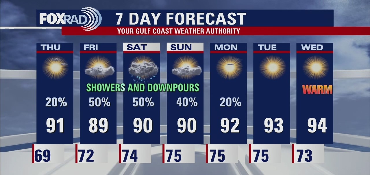
Friday and Saturday will bring scattered showers and downpours across Southeast Texas. Look for the rain chances to decrease at the end of the weekend with drier air and higher temperatures returning with the work week.
Friday and Saturday will bring scattered showers and downpours across Southeast Texas. Look for the rain chances to decrease at the end of the weekend with drier air and higher temperatures returning with the work week.

Thursday evening weather forecast with Meteorologist John Dawson
Friday and Saturday will bring scattered showers and downpours across Southeast Texas. Look for the rain chances to decrease at the end of the weekend with drier air and higher temperatures returning with the work week.
Friday and Saturday will bring scattered showers and downpours across Southeast Texas. Look for the rain chances to decrease at the end of the weekend with drier air and higher temperatures returning with the work week.
Thursday afternoon weather forecast with Meteorologist Lena Maria
We begin transitioning toward a more humid, showery weather pattern as we head into the weekend. But, it's not going to stick around for long. Rain chances will taper as we head into next week, with a ridge of the high-pressure building. Toasty sunshine returns by the middle of next week. In the Atlantic, Tropical Storm Fiona is set to bring impacts to portions of the Caribbean before turning out to sea.
We begin transitioning toward a more humid, showery weather pattern as we head into the weekend. But, it's not going to stick around for long. Rain chances will taper as we head into next week, with a ridge of the high-pressure building. Toasty sunshine returns by the middle of next week. In the Atlantic, Tropical Storm Fiona is set to bring impacts to portions of the Caribbean before turning out to sea.
Isolated showers and storms Thursday, mainly south
Hopefully, you enjoyed the low(er) humidity because here comes the moisture! Breezes out of the east, eventually turning southerly will bring a noticeable increase in humidity as we close out the week. Along with that, rain chances will also be on the rise. It won't be a washout, but a few downpours and thunderstorms will also be in the mix over the weekend. Heading into next week, we dry out and warm up. In the tropics, our 6th named storm of the season has formed. Tropical Storm Fiona, however, is not expected to impact the Gulf.
Hopefully, you enjoyed the low(er) humidity because here comes the moisture! Breezes out of the east, eventually turning southerly will bring a noticeable increase in humidity as we close out the week. Along with that, rain chances will also be on the rise. It won't be a washout, but a few downpours and thunderstorms will also be in the mix over the weekend. Heading into next week, we dry out and warm up. In the tropics, our 6th named storm of the season has formed. Tropical Storm Fiona, however, is not expected to impact the Gulf.
Wednesday evening weather forecast with Meteorologist John Dawson
Thursday will start the transition back to a more humid pattern for Houston headed into the weekend. Expect some showers and thunderstorms scattered across Southeast Texas over the weekend. For the latest on the new tropical cyclone in the Atlantic, check out our FOX 26 YouTube Channel.
Thursday will start the transition back to a more humid pattern for Houston headed into the weekend. Expect some showers and thunderstorms scattered across Southeast Texas over the weekend. For the latest on the new tropical cyclone in the Atlantic, check out our FOX 26 YouTube Channel.
Wednesday afternoon weather forecast with Meteorologist Lena Maria
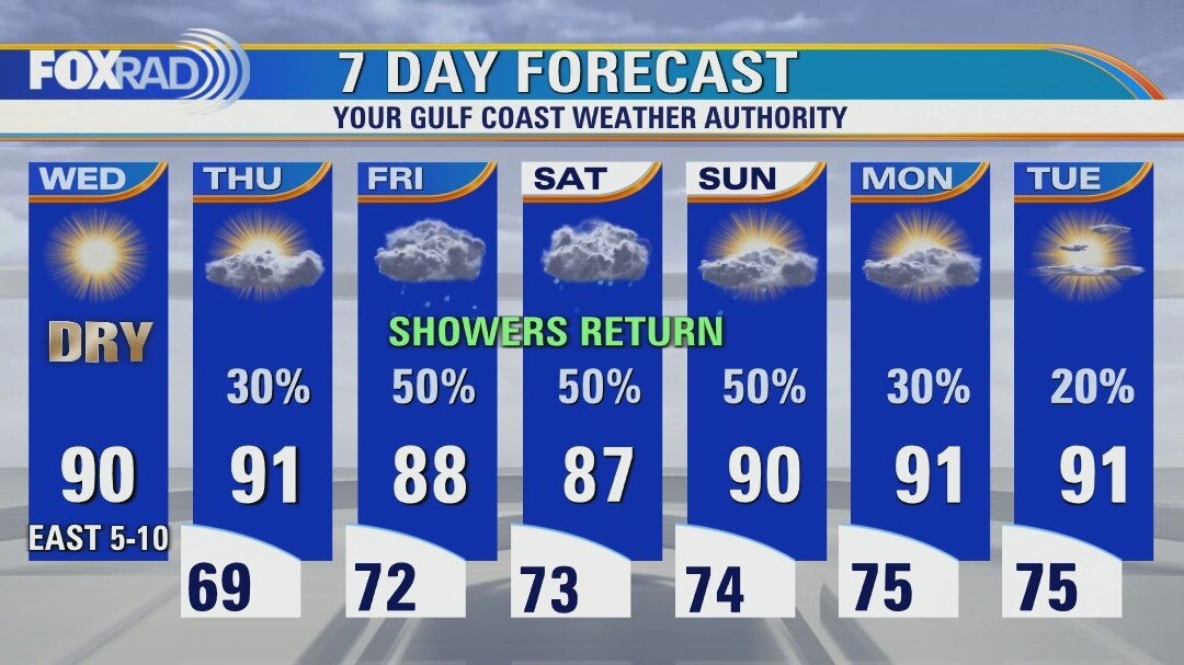
One last day of blissful weather, and then tomorrow we begin to transition to a more humid pattern heading into the weekend. A few showers and storms south of I-10 are possible Thursday. More coverage of scattered showers and storms will be around Friday-Sunday, so something to keep an eye on for outdoor plans. There is a new Tropical Depression in the Atlantic, but it is not a concern for the Gulf.
One last day of blissful weather, and then tomorrow we begin to transition to a more humid pattern heading into the weekend. A few showers and storms south of I-10 are possible Thursday. More coverage of scattered showers and storms will be around Friday-Sunday, so something to keep an eye on for outdoor plans. There is a new Tropical Depression in the Atlantic, but it is not a concern for the Gulf.
Slightly cooler Wednesday morning, then sunny and dry with highs near 90
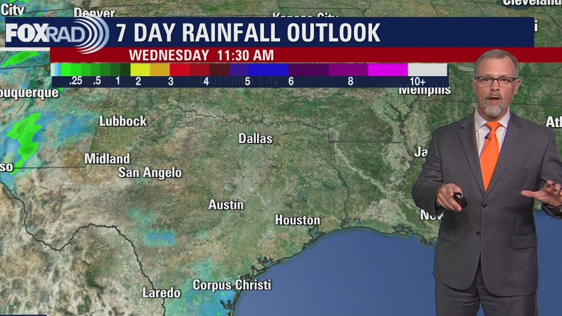
What a wonderful Wednesday weather forecast! This morning's temperatures were the coolest since late May and the afternoon will be great with sunshine and warm, dry air. A front returns from the south tomorrow, so storms will be possible, especially south of Houston. A showery pattern is expected for Friday and the weekend with scattered storms possible and highs in the upper 80s. The tropics remain quiet with only one tropical wave to watch far from Texas and it should be slow to develop.
What a wonderful Wednesday weather forecast! This morning's temperatures were the coolest since late May and the afternoon will be great with sunshine and warm, dry air. A front returns from the south tomorrow, so storms will be possible, especially south of Houston. A showery pattern is expected for Friday and the weekend with scattered storms possible and highs in the upper 80s. The tropics remain quiet with only one tropical wave to watch far from Texas and it should be slow to develop.
Wednesday morning weather forecast
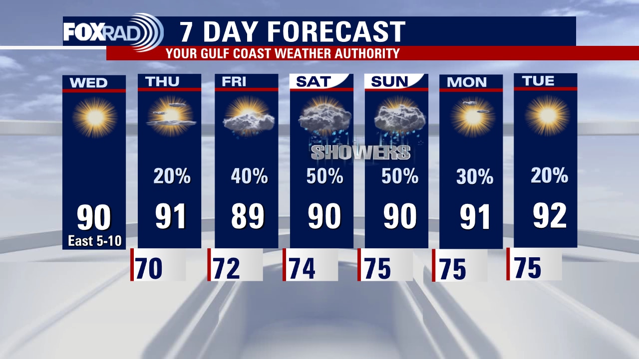
One more day of slightly lower humidity for Houston on Wednesday. As we move towards the weekend, Gulf moisture returns to Southeast Texas. More clouds and showers return for the weekend. There could be an isolated heavy downpour on Friday or Saturday mixed in with the afternoon showers. The rainy pattern lingers for the start of the work week.
One more day of slightly lower humidity for Houston on Wednesday. As we move towards the weekend, Gulf moisture returns to Southeast Texas. More clouds and showers return for the weekend. There could be an isolated heavy downpour on Friday or Saturday mixed in with the afternoon showers. The rainy pattern lingers for the start of the work week.
Tuesday evening weather forecast
One more day of slightly lower humidity for Houston on Wednesday. As we move towards the weekend, Gulf moisture returns to Southeast Texas. More clouds and showers return for the weekend. There could be an isolated heavy downpour on Friday or Saturday mixed in with the afternoon showers. The rainy pattern lingers for the start of the work week.
One more day of slightly lower humidity for Houston on Wednesday. As we move towards the weekend, Gulf moisture returns to Southeast Texas. More clouds and showers return for the weekend. There could be an isolated heavy downpour on Friday or Saturday mixed in with the afternoon showers. The rainy pattern lingers for the start of the work week.

Sunny and warm Tuesday with lower humidity; isolated showers south of Houston
Beautiful, almost fall-like weather is in place and temperatures this morning reached the 60s in many spots and will likely do the same tonight. Afternoon temperatures will remain very warm, but with comfortable humidity. A front that moved through and brought this drier air will return as a warm front beginning Thursday, so rain chances will increase and the rainiest days appear to be Friday and Saturday. Today marks the anniversary of Hurricane Ike's impact on our area, but this year's quiet pattern continues for now.
Beautiful, almost fall-like weather is in place and temperatures this morning reached the 60s in many spots and will likely do the same tonight. Afternoon temperatures will remain very warm, but with comfortable humidity. A front that moved through and brought this drier air will return as a warm front beginning Thursday, so rain chances will increase and the rainiest days appear to be Friday and Saturday. Today marks the anniversary of Hurricane Ike's impact on our area, but this year's quiet pattern continues for now.
Tuesday morning weather forecast
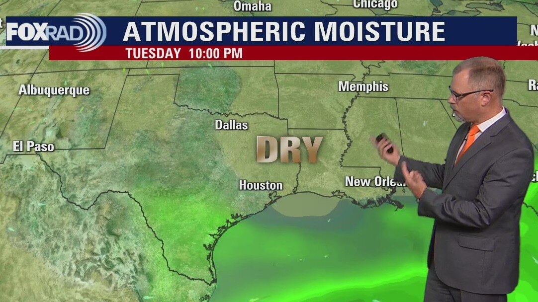
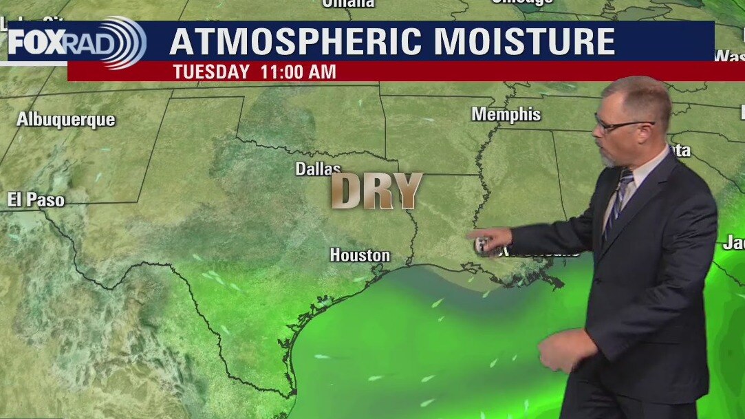
Lower humidity levels continue to settle into southeast Texas behind Sunday's weak front. Houston should see lots of sunshine for the next couple of days. Towards the end of the week look for more humidity and rain chances to return to the area.
Lower humidity levels continue to settle into southeast Texas behind Sunday's weak front. Houston should see lots of sunshine for the next couple of days. Towards the end of the week look for more humidity and rain chances to return to the area.
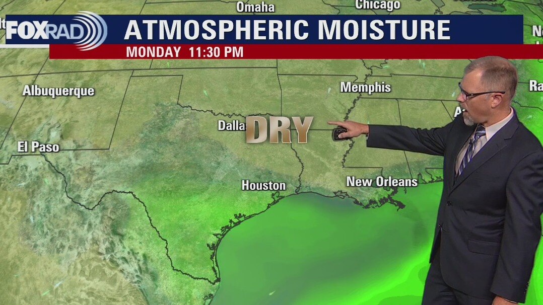
Monday evening weather forecast
Lower humidity levels continue to settle into southeast Texas behind Sunday's weak front. Houston should see lots of sunshine for the next couple of days. Towards the end of the week look for more humidity and rain chances to return to the area.
Lower humidity levels continue to settle into southeast Texas behind Sunday's weak front. Houston should see lots of sunshine for the next couple of days. Towards the end of the week look for more humidity and rain chances to return to the area.
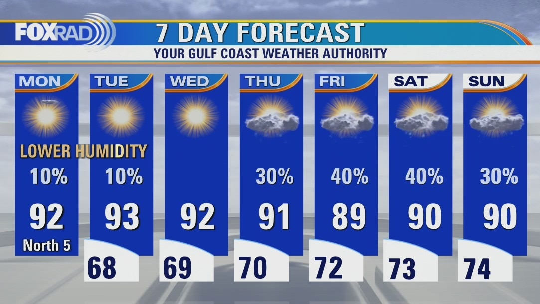
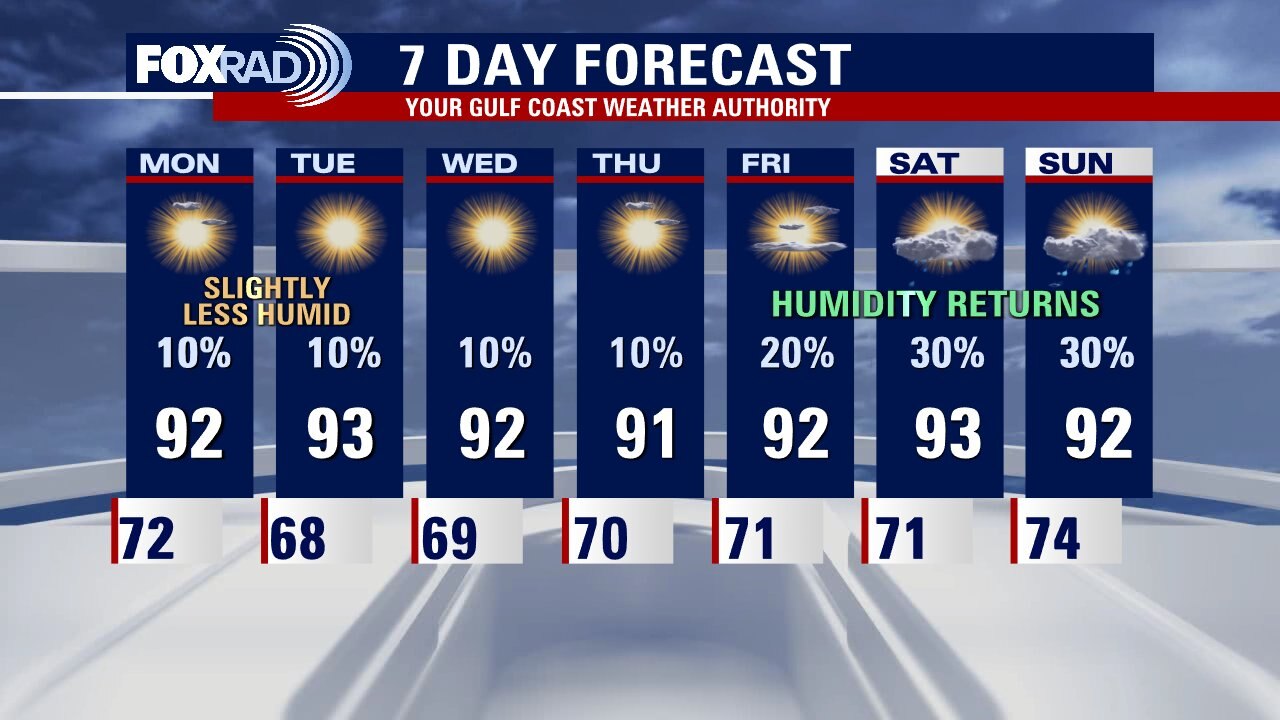
Mostly sunny and warm Monday with slightly lower humidity
We're off to a great start this week with slightly lower humidity, mostly sunny skies and only isolated showers mostly near the coast. Overnight lows could reach the upper 60s over the next couple of nights. Late this week, more moisture returns which should bring increasing cloud cover along with scattered showers and possible storms. The tropics remain quiet.
We're off to a great start this week with slightly lower humidity, mostly sunny skies and only isolated showers mostly near the coast. Overnight lows could reach the upper 60s over the next couple of nights. Late this week, more moisture returns which should bring increasing cloud cover along with scattered showers and possible storms. The tropics remain quiet.
Sunday night leading into Monday morning weather forecast
Monday and Tuesday morning will feel a bit different across southeast Texas with slightly drier air in place behind a week cold front that arrived to Houston Sunday. Most of the week will feel pleasant with some mornings in the upper 60s. Afternoons will be warm with afternoon highs in the lower 90s. Rain chances remain low until next weekend.
Monday and Tuesday morning will feel a bit different across southeast Texas with slightly drier air in place behind a week cold front that arrived to Houston Sunday. Most of the week will feel pleasant with some mornings in the upper 60s. Afternoons will be warm with afternoon highs in the lower 90s. Rain chances remain low until next weekend.
Sunday Morning Forecast with Meteorologist Lena Maria
More pleasant weather on the horizon for much of this week, as a weak front ushers in drier air. Mornings this week are going to be blissful, with many experiencing 60s for lows for several days in a row! Plan for sunny, warm and mostly dry afternoons aside from a spot shower mainly along the coast. Winds look to turn more easterly by the weekend, slightly increasing temperatures, humidity and rain chances.
More pleasant weather on the horizon for much of this week, as a weak front ushers in drier air. Mornings this week are going to be blissful, with many experiencing 60s for lows for several days in a row! Plan for sunny, warm and mostly dry afternoons aside from a spot shower mainly along the coast. Winds look to turn more easterly by the weekend, slightly increasing temperatures, humidity and rain chances.
Saturday Morning Forecast with Meteorologist Lena Maria
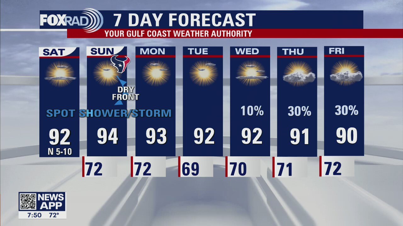
A mostly sunny and dry weekend awaits us, with gradually warming temperatures. Next week? More of the same. A dry front will usher in slightly lower humidity, with pleasant weather persisting though rain chances may increase some toward the tail end of the week. The Atlantic looks more like the beginning of Hurricane Season than the peak, but... we'll take it. Only one named storm churning, no where near land and Hurricane Earl will begin to dissipate over the course of the weekend.
A mostly sunny and dry weekend awaits us, with gradually warming temperatures. Next week? More of the same. A dry front will usher in slightly lower humidity, with pleasant weather persisting though rain chances may increase some toward the tail end of the week. The Atlantic looks more like the beginning of Hurricane Season than the peak, but... we'll take it. Only one named storm churning, no where near land and Hurricane Earl will begin to dissipate over the course of the weekend.
Saturday morning weather forecast
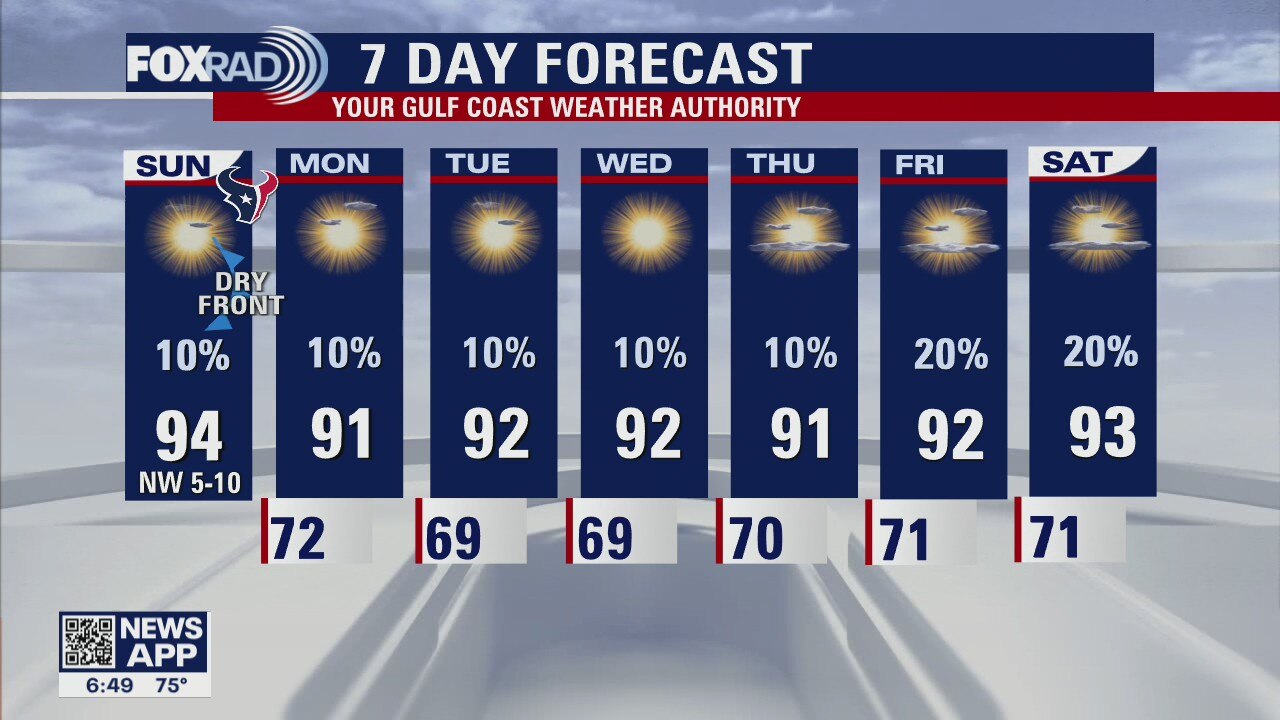
Our weather is shaping up nicely for this weekend with plenty of sunshine and slightly less humidity. For the Texans opener at NRG stadium on Sunday, expect very warm conditions with highs in the mid 90s, although there is a chance for storms that day, it looks like most of them will be south of Houston. Beyond that next week is shaping up very nicely with slightly more pleasant low temperatures in the upper 60s and low 70s.
Our weather is shaping up nicely for this weekend with plenty of sunshine and slightly less humidity. For the Texans opener at NRG stadium on Sunday, expect very warm conditions with highs in the mid 90s, although there is a chance for storms that day, it looks like most of them will be south of Houston. Beyond that next week is shaping up very nicely with slightly more pleasant low temperatures in the upper 60s and low 70s.
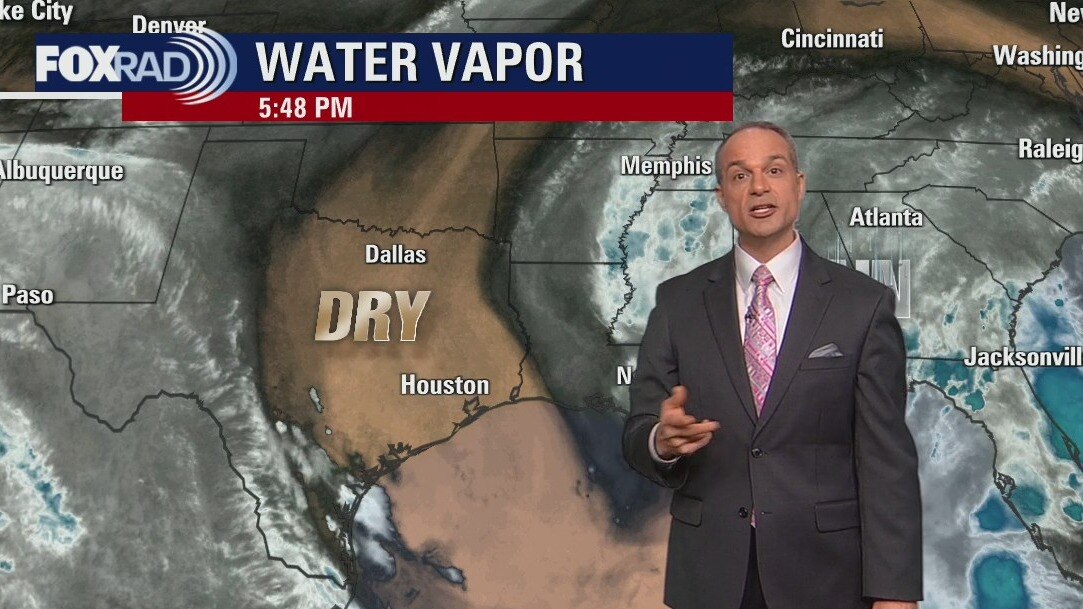
Friday evening weather forecast
Our weather is shaping up nicely for this weekend with plenty of sunshine and slightly less humidity. For the Texans opener at NRG stadium on Sunday, expect very warm conditions with highs in the mid 90s, although there is a chance for storms that day, it looks like most of them will be south of Houston. Beyond that next week is shaping up very nicely with slightly more pleasant low temperatures in the upper 60s and low 70s.
Our weather is shaping up nicely for this weekend with plenty of sunshine and slightly less humidity. For the Texans opener at NRG stadium on Sunday, expect very warm conditions with highs in the mid 90s, although there is a chance for storms that day, it looks like most of them will be south of Houston. Beyond that next week is shaping up very nicely with slightly more pleasant low temperatures in the upper 60s and low 70s.