


Friday morning weather forecast
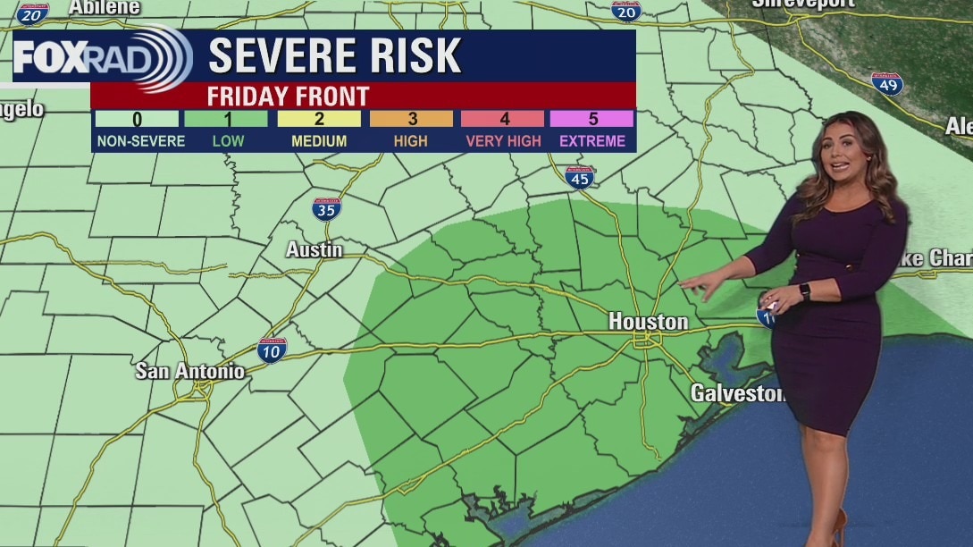
It looks like the weather will be quite messy for much of Friday leading up to World Series Game 1 with first pitch at 7:03 pm at Minute Maid Park. Rain will build in by early Friday AM with the heaviest rain expected from 10 AM until around 4 PM. This is the time a few storms could be severe with the biggest threat in our SW communities. An isolated tornado, hail, flooding and damaging wind gusts will all be possible so stay alert! Heavy rain should taper off close to First Pitch time but scattered showers will likely still be around. We should dry out and clear out over the weekend with pleasant and dry weather expected for Halloween. A few showers return to area by next Tuesday.
It looks like the weather will be quite messy for much of Friday leading up to World Series Game 1 with first pitch at 7:03 pm at Minute Maid Park. Rain will build in by early Friday AM with the heaviest rain expected from 10 AM until around 4 PM. This is the time a few storms could be severe with the biggest threat in our SW communities. An isolated tornado, hail, flooding and damaging wind gusts will all be possible so stay alert! Heavy rain should taper off close to First Pitch time but scattered showers will likely still be around. We should dry out and clear out over the weekend with pleasant and dry weather expected for Halloween. A few showers return to area by next Tuesday.

Calm, quiet, and windy with temps in the 70s Thursday evening
It looks like the weather will be quite messy for much of Friday leading up to World Series Game 1 with the first pitch at 7:03 p.m. at Minute Maid Park. Rain will build in by early Friday morning with the heaviest rain expected from 10 a.m. until around 4 p.m. This is the time a few storms could be severe with the biggest threat in our southwest communities. An isolated tornado, hail, flooding, and damaging wind gusts will all be possible so stay alert! Heavy rain should taper off close to the first pitch time but scattered showers will likely still be around. We should dry out and clear out over the weekend with pleasant and dry weather expected for Halloween. A few showers return to the area by next Tuesday.
It looks like the weather will be quite messy for much of Friday leading up to World Series Game 1 with the first pitch at 7:03 p.m. at Minute Maid Park. Rain will build in by early Friday morning with the heaviest rain expected from 10 a.m. until around 4 p.m. This is the time a few storms could be severe with the biggest threat in our southwest communities. An isolated tornado, hail, flooding, and damaging wind gusts will all be possible so stay alert! Heavy rain should taper off close to the first pitch time but scattered showers will likely still be around. We should dry out and clear out over the weekend with pleasant and dry weather expected for Halloween. A few showers return to the area by next Tuesday.

Pleasant, with some possible scattered showers Thursday afternoon
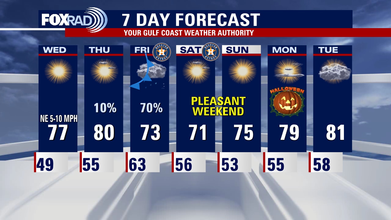
Today will be pleasant and quiet, with the possibility of some scattered lighter showers and storms beginning overnight. The bulk of the heavier rain and the possibility for stronger storms arrives by mid-morning Friday through much of Friday afternoon. Give yourself some extra time to navigate any issues that might pop up getting around town, rain will gradually dwindle throughout the evening, and Saturday we hang onto some clouds but north breezes will usher in cooler, drier air by Game 2. Sunday looks great for outdoor plans and trick-o-treating, winds will be lighter. Halloween Monday looks great locally too. We'll be keeping our eye on Philly's forecast, as our front heads there next, and could cause some issues for Monday's game.
Today will be pleasant and quiet, with the possibility of some scattered lighter showers and storms beginning overnight. The bulk of the heavier rain and the possibility for stronger storms arrives by mid-morning Friday through much of Friday afternoon. Give yourself some extra time to navigate any issues that might pop up getting around town, rain will gradually dwindle throughout the evening, and Saturday we hang onto some clouds but north breezes will usher in cooler, drier air by Game 2. Sunday looks great for outdoor plans and trick-o-treating, winds will be lighter. Halloween Monday looks great locally too. We'll be keeping our eye on Philly's forecast, as our front heads there next, and could cause some issues for Monday's game.
Chilly again Thursday morning, then mostly sunny and mild
Storms, even some heavy ones, are expected to mess with our Friday and Game 1 World Series plans. After a very nice day today, showers could move in overnight followed by numerous storms and a chance for severe storms by Friday after. Fortunately, weather looks great for the weekend and Halloween.
Storms, even some heavy ones, are expected to mess with our Friday and Game 1 World Series plans. After a very nice day today, showers could move in overnight followed by numerous storms and a chance for severe storms by Friday after. Fortunately, weather looks great for the weekend and Halloween.
Thursday morning weather forecast
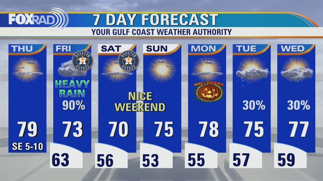
It's been another beautiful day across SE Texas with high pressure bringing quiet weather across the state. After a chilly start Thursday morning, we should warm nicely to near 80 by the afternoon. Big changes roll in Friday as another storm system brings widespread rain and the threat for a few stronger storms. That means soggy weather for festivities leading up to the world series Game #1 Friday at Minute Main Park. Rain should start to taper off late Friday night with pleasant, sunny and dry weather expected for the weekend. Tropics are fairly quiet but we are monitoring one tropical wave north of Puerto Rico that could develop and head towards Bermuda.
It's been another beautiful day across SE Texas with high pressure bringing quiet weather across the state. After a chilly start Thursday morning, we should warm nicely to near 80 by the afternoon. Big changes roll in Friday as another storm system brings widespread rain and the threat for a few stronger storms. That means soggy weather for festivities leading up to the world series Game #1 Friday at Minute Main Park. Rain should start to taper off late Friday night with pleasant, sunny and dry weather expected for the weekend. Tropics are fairly quiet but we are monitoring one tropical wave north of Puerto Rico that could develop and head towards Bermuda.

Wednesday evening weather forecast with Meteorologist Remeisha Shade
It's been another beautiful day across SE Texas with high pressure bringing quiet weather across the state. After a chilly start Thursday morning, we should warm nicely to near 80 by the afternoon. Big changes roll in Friday as another storm system brings widespread rain and the threat for a few stronger storms. That means soggy weather for festivities leading up to the world series Game #1 Friday at Minute Main Park. Rain should start to taper off late Friday night with pleasant, sunny and dry weather expected for the weekend. Tropics are fairly quiet but we are monitoring one tropical wave north of Puerto Rico that could develop and head towards Bermuda.
It's been another beautiful day across SE Texas with high pressure bringing quiet weather across the state. After a chilly start Thursday morning, we should warm nicely to near 80 by the afternoon. Big changes roll in Friday as another storm system brings widespread rain and the threat for a few stronger storms. That means soggy weather for festivities leading up to the world series Game #1 Friday at Minute Main Park. Rain should start to taper off late Friday night with pleasant, sunny and dry weather expected for the weekend. Tropics are fairly quiet but we are monitoring one tropical wave north of Puerto Rico that could develop and head towards Bermuda.
Sunny and dry with light winds for Wednesday afternoon
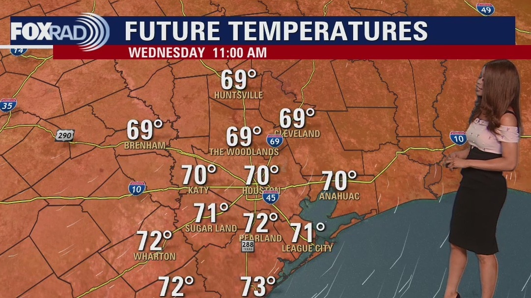
Today will be calm and pleasant, with slightly warmer daytime highs and lighter winds. Under clear skies, temperatures will fall pretty effectively tonight leading to a chilly start on Thursday morning. Our next system keeps us fairly soggy from start to finish on Friday, so you'll want to allow for extra time to get around. There is a small possibility of a few stronger storms, and pockets of heavier rainfall. Conditions look much better for Game 2 of the World Series, and there's nothing spooky in store for Halloween on Monday either. Though, we do have another shot at rain middle of next week.
Today will be calm and pleasant, with slightly warmer daytime highs and lighter winds. Under clear skies, temperatures will fall pretty effectively tonight leading to a chilly start on Thursday morning. Our next system keeps us fairly soggy from start to finish on Friday, so you'll want to allow for extra time to get around. There is a small possibility of a few stronger storms, and pockets of heavier rainfall. Conditions look much better for Game 2 of the World Series, and there's nothing spooky in store for Halloween on Monday either. Though, we do have another shot at rain middle of next week.
Chilly Wednesday morning, then sunny and dry
Our weather today looks terrific, so enjoy. Unfortunately, Friday should be rainy just about all day as we gear up for game 1 of the World Series (only on Fox 26). Sunshine will return for the weekend and I'm happy to say that Halloween looks Boo-tiful for now. (yep, I went there)
Our weather today looks terrific, so enjoy. Unfortunately, Friday should be rainy just about all day as we gear up for game 1 of the World Series (only on Fox 26). Sunshine will return for the weekend and I'm happy to say that Halloween looks Boo-tiful for now. (yep, I went there)
Wednesday morning weather forecast
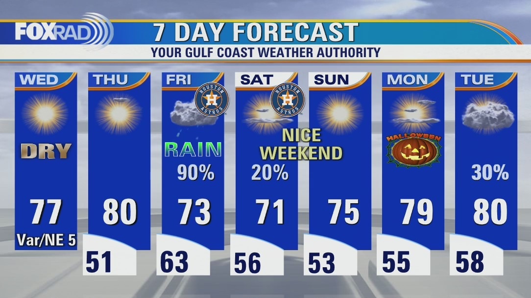
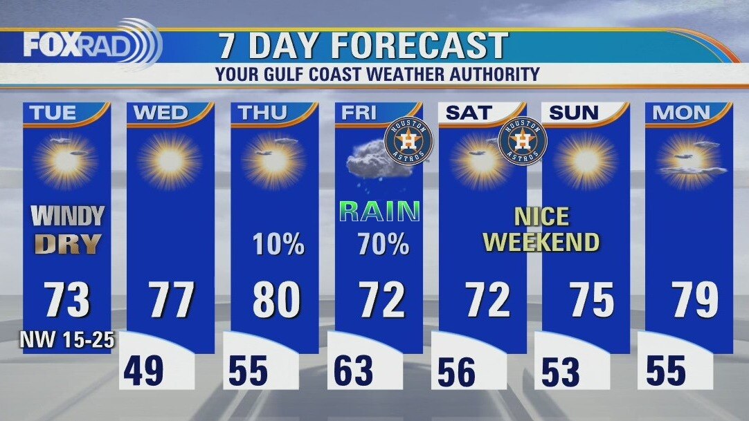
Line of strong to severe storms pushed across SE Texas overnight with a few reports of some downed trees in parts of Montgomery County. Front has cleared the area with cool temperatures in the 40s and dry weather expected tonight. Next few days should be pleasant and dry before our next storm system brings another decent round of rain by Friday just in time for the World Series Game 1 at Minute Maid Park.
Line of strong to severe storms pushed across SE Texas overnight with a few reports of some downed trees in parts of Montgomery County. Front has cleared the area with cool temperatures in the 40s and dry weather expected tonight. Next few days should be pleasant and dry before our next storm system brings another decent round of rain by Friday just in time for the World Series Game 1 at Minute Maid Park.
Tuesday evening weather forecast with Meteorologist Remeisha Shade
Line of strong to severe storms pushed across SE Texas overnight with a few reports of some downed trees in parts of Montgomery County. Front has cleared the area with cool temperatures in the 40s and dry weather expected tonight. Next few days should be pleasant and dry before our next storm system brings another decent round of rain by Friday just in time for the World Series Game 1 at Minute Maid Park.
Line of strong to severe storms pushed across SE Texas overnight with a few reports of some downed trees in parts of Montgomery County. Front has cleared the area with cool temperatures in the 40s and dry weather expected tonight. Next few days should be pleasant and dry before our next storm system brings another decent round of rain by Friday just in time for the World Series Game 1 at Minute Maid Park.

Tuesday afternoon weather forecast with Meteorologist John Dawson
Sunshine and much drier air is moving in today and should stick around through Thursday. Friday brings game 1 of the World Series here in H-town and rain does look likely - maybe even a few heavy downpours.
Sunshine and much drier air is moving in today and should stick around through Thursday. Friday brings game 1 of the World Series here in H-town and rain does look likely - maybe even a few heavy downpours.
Windy, sunny, cool and very dry Tuesday
A line of severe storms knocked out power to more than 100k customers overnight, but sunshine and much drier air is moving in today and should stick around through Thursday. Friday brings game 1 of the World Series here in H-town and rain does look likely - maybe even a few heavy downpours.
A line of severe storms knocked out power to more than 100k customers overnight, but sunshine and much drier air is moving in today and should stick around through Thursday. Friday brings game 1 of the World Series here in H-town and rain does look likely - maybe even a few heavy downpours.
Tuesday morning weather forecast
Threat for severe weather will be increasing across SE Texas overnight as a strong cold front and the remnants of Roslyn push into our area. There's a category 2 out of 5 slight risk for a few severe storms overnight. Main threats would be damaging winds around 60 mph, hail and some heavy downpours that could lead to a few flood advisories. Tornado threat is low but can't be ruled out. Main timeframe for this is midnight until 4 am. Cold front quickly moves in Tuesday morning ushering in cooler and drier air. Another cold front arrives Friday which will mean wet weather for Game 1 of the World Series. Fortunately, Minute Maid Park has a roof so it shouldn't be an issue!
Threat for severe weather will be increasing across SE Texas overnight as a strong cold front and the remnants of Roslyn push into our area. There's a category 2 out of 5 slight risk for a few severe storms overnight. Main threats would be damaging winds around 60 mph, hail and some heavy downpours that could lead to a few flood advisories. Tornado threat is low but can't be ruled out. Main timeframe for this is midnight until 4 am. Cold front quickly moves in Tuesday morning ushering in cooler and drier air. Another cold front arrives Friday which will mean wet weather for Game 1 of the World Series. Fortunately, Minute Maid Park has a roof so it shouldn't be an issue!
Monday evening weather forecast
Threat for severe weather will be increasing across SE Texas overnight as a strong cold front and the remnants of Roslyn push into our area. There's a category 2 out of 5 slight risk for a few severe storms overnight. Main threats would be damaging winds around 60 mph, hail and some heavy downpours that could lead to a few flood advisories. Tornado threat is low but can't be ruled out. Main timeframe for this is midnight until 4 am. Cold front quickly moves in Tuesday morning ushering in cooler and drier air. Another cold front arrives Friday which will mean wet weather for Game 1 of the World Series. Fortunately, Minute Maid Park has a roof so it shouldn't be an issue!
Threat for severe weather will be increasing across SE Texas overnight as a strong cold front and the remnants of Roslyn push into our area. There's a category 2 out of 5 slight risk for a few severe storms overnight. Main threats would be damaging winds around 60 mph, hail and some heavy downpours that could lead to a few flood advisories. Tornado threat is low but can't be ruled out. Main timeframe for this is midnight until 4 am. Cold front quickly moves in Tuesday morning ushering in cooler and drier air. Another cold front arrives Friday which will mean wet weather for Game 1 of the World Series. Fortunately, Minute Maid Park has a roof so it shouldn't be an issue!
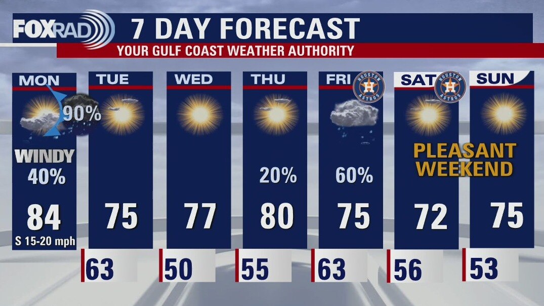
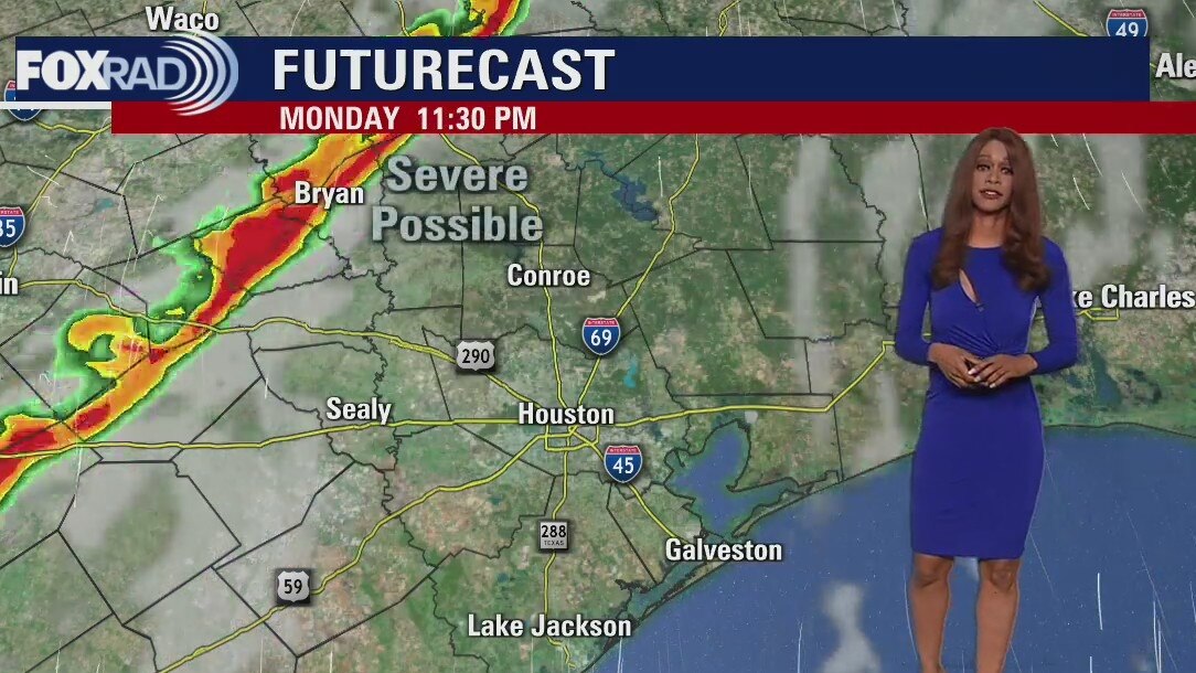
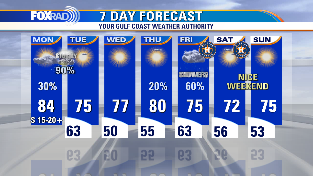
Monday afternoon weather forecast with Meteorologist John Dawson
The world series is coming to Houston and so far, it looks rainy for game 1 and nice for game 2 - the roof will most likely be closed on Friday. In the short term, our main concern is an expected line of thunderstorms overnight tonight between around 10 p.m. and 4 a.m. Severe winds are possible along with brief heavy rain and lightning, but nice weather will follow for Tuesday and Wednesday
The world series is coming to Houston and so far, it looks rainy for game 1 and nice for game 2 - the roof will most likely be closed on Friday. In the short term, our main concern is an expected line of thunderstorms overnight tonight between around 10 p.m. and 4 a.m. Severe winds are possible along with brief heavy rain and lightning, but nice weather will follow for Tuesday and Wednesday
Monday morning weather forecast with Chief Meteorologist Mike Iscovitz
The world series is coming to Houston and so far, it looks rainy for game 1 and nice for game 2 - the roof will most likely be closed on Friday. In the short term, our main concern is an expected line of thunderstorms overnight tonight between around 10pm and 4am. Severe winds are possible along with brief heavy rain and lightning, but nice weather will follow for Tuesday and Wednesday.
The world series is coming to Houston and so far, it looks rainy for game 1 and nice for game 2 - the roof will most likely be closed on Friday. In the short term, our main concern is an expected line of thunderstorms overnight tonight between around 10pm and 4am. Severe winds are possible along with brief heavy rain and lightning, but nice weather will follow for Tuesday and Wednesday.
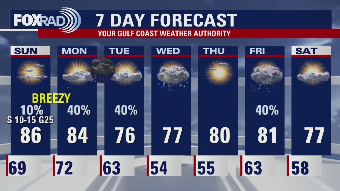
Very breezy, in the 80s this Sunday evening
There are a couple of fronts coming to Houston this week. Both will bring some showers/storms and cooler temperatures. The first batch of rain should reach Houston Monday night after midnight. Look for sunny skies and pleasant afternoons Tuesday and Wednesday. The second front will arrive in Southeast Texas at the end of the week. Currently, it looks like it should leave us with a great weekend for outdoor events.
There are a couple of fronts coming to Houston this week. Both will bring some showers/storms and cooler temperatures. The first batch of rain should reach Houston Monday night after midnight. Look for sunny skies and pleasant afternoons Tuesday and Wednesday. The second front will arrive in Southeast Texas at the end of the week. Currently, it looks like it should leave us with a great weekend for outdoor events.

Sunday Morning Forecast with Meteorologist Lena Maria Arango
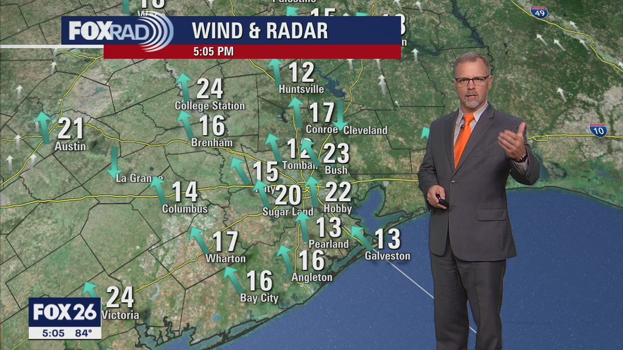
Another warm and windy day is on tap to close out the weekend, with a very humid start to the work week in the low 70s. Most of the day Monday will be mostly cloudy and showery in nature, with the bulk of the precip holding off until the overnight hours. It could get briefly loud, though pre-dawn as a potent line of storms pushes through. The Storm Prediction Center currently has our area flagged at a 2 on the 1-5 scale for strong to severe weather, that would mainly include gusty winds, heavy rain, and frequent thunder and lightning. The cool-down behind that is mild, and doesn't last long with another front bringing the return of rain chances toward the end of the week.
Another warm and windy day is on tap to close out the weekend, with a very humid start to the work week in the low 70s. Most of the day Monday will be mostly cloudy and showery in nature, with the bulk of the precip holding off until the overnight hours. It could get briefly loud, though pre-dawn as a potent line of storms pushes through. The Storm Prediction Center currently has our area flagged at a 2 on the 1-5 scale for strong to severe weather, that would mainly include gusty winds, heavy rain, and frequent thunder and lightning. The cool-down behind that is mild, and doesn't last long with another front bringing the return of rain chances toward the end of the week.
Warm and windy Saturday afternoon in the 80s
Warm and windy weather will persist for the rest of the weekend across SE Texas with mainly dry weather expected. There's just a 10% chance of a shower Sunday PM. Rain chances increase Monday and Tuesday with a cold front moving through and remnants of Roslyn heading our way. Best shot for rain will be Monday night with an 80% chance. Another round of rain returns late in the week with another front.
Warm and windy weather will persist for the rest of the weekend across SE Texas with mainly dry weather expected. There's just a 10% chance of a shower Sunday PM. Rain chances increase Monday and Tuesday with a cold front moving through and remnants of Roslyn heading our way. Best shot for rain will be Monday night with an 80% chance. Another round of rain returns late in the week with another front.

Saturday Morning Forecast with Meteorologist Lena Maria Arango
Hold onto your cowboy hats, it's gonna be a windy weekend! Humidity will be on the rise ahead of our next frontal system, with overnight lows once again exceeding 70. A much-needed dose of beneficial rainfall arrives overnight Monday into Tuesday. Behind that, we'll get a couple of quiet and slightly cooler days. This front does not look to provide as much of a drastic drop in temperatures as the last one. Humidity quickly builds back in, and rain chances return on Friday.
Hold onto your cowboy hats, it's gonna be a windy weekend! Humidity will be on the rise ahead of our next frontal system, with overnight lows once again exceeding 70. A much-needed dose of beneficial rainfall arrives overnight Monday into Tuesday. Behind that, we'll get a couple of quiet and slightly cooler days. This front does not look to provide as much of a drastic drop in temperatures as the last one. Humidity quickly builds back in, and rain chances return on Friday.