

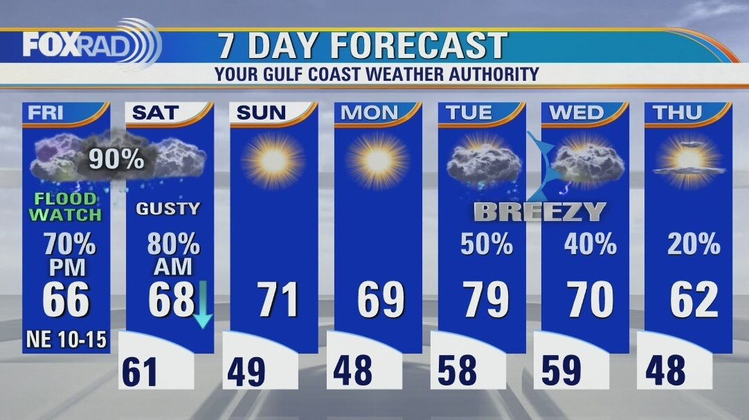
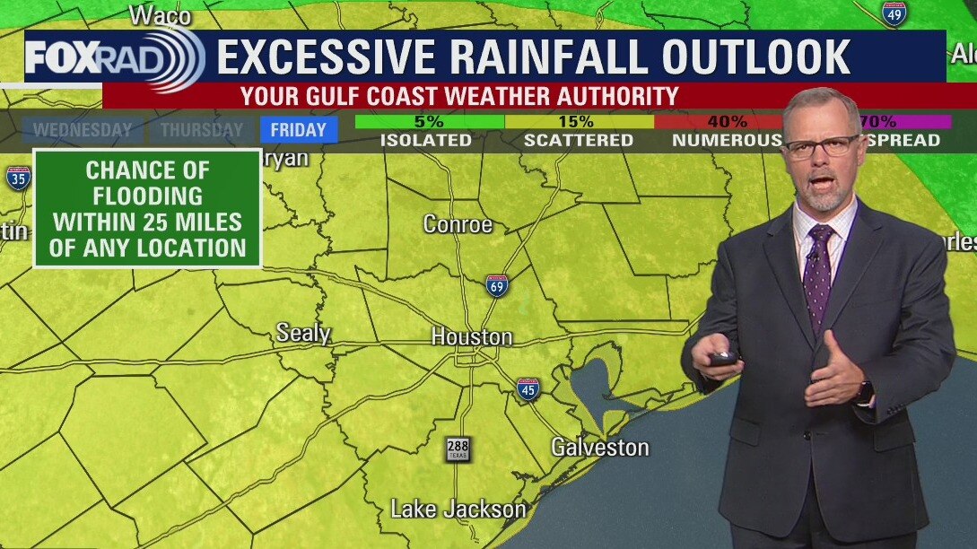
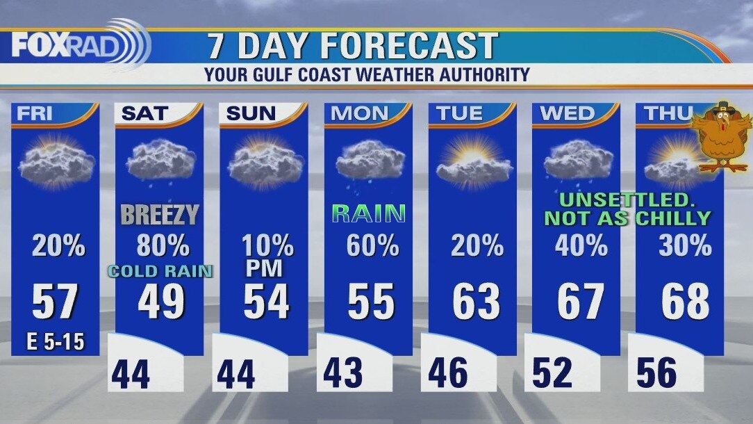
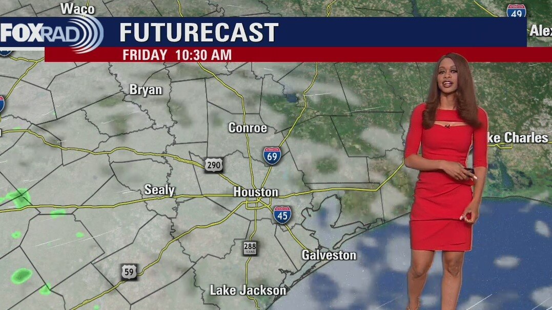
Friday starts dry, rain returns afternoon & evening
Early morning shoppers can look forward to dry conditions as we experience a lull in rainfall. But, you may want to hurry home to carry all your purchases inside before another round of rain moves in. Pulses of heavy rain return this afternoon and evening, with a flood watch in effect through noon Saturday. Conditions will rapidly improve Saturday afternoon, with a few days of dry weather before our next system. Things could get messy again with the potential for a stronger front on Tuesday, so stay tuned for details on that.
Early morning shoppers can look forward to dry conditions as we experience a lull in rainfall. But, you may want to hurry home to carry all your purchases inside before another round of rain moves in. Pulses of heavy rain return this afternoon and evening, with a flood watch in effect through noon Saturday. Conditions will rapidly improve Saturday afternoon, with a few days of dry weather before our next system. Things could get messy again with the potential for a stronger front on Tuesday, so stay tuned for details on that.


Thanksgiving forecast: Rainy weather pattern extending into weekend
It looks like the rainy Thanksgiving weather pattern will extend into the weekend.
It looks like the rainy Thanksgiving weather pattern will extend into the weekend.
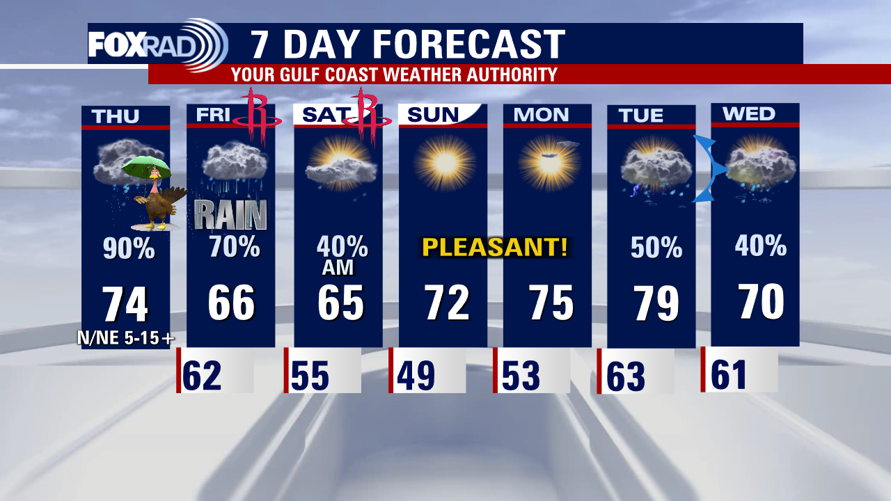
Thanksgiving forecast: Heavy rain and storms in Houston
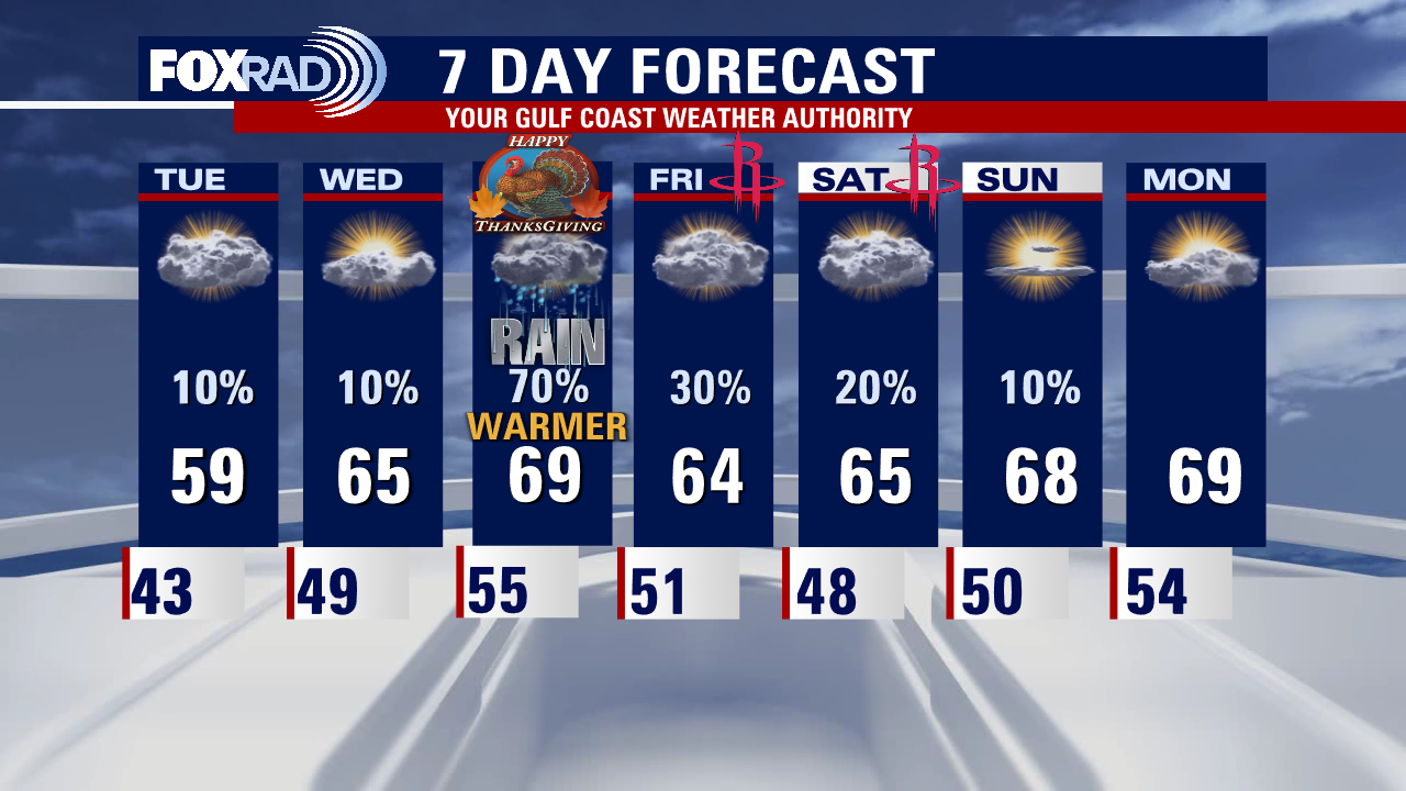
Rounds of heavy rain and storms will be around for Turkey Day and Black Friday shoppers, but once we clear that Saturday morning the weekend's all gravy! We'll warm to near 80 with several sunny, dry days for traveling back home before our next front brings the return of stormy conditions middle of next week.
Rounds of heavy rain and storms will be around for Turkey Day and Black Friday shoppers, but once we clear that Saturday morning the weekend's all gravy! We'll warm to near 80 with several sunny, dry days for traveling back home before our next front brings the return of stormy conditions middle of next week.
Thanksgiving forecast: Widespread storms, downpours mid-morning through early evening
Rounds of heavy rain and storms will be around for Turkey Day and Black Friday shoppers, but once we clear that Saturday morning the weekend's all gravy! We'll warm to near 80 with several sunny, dry days for traveling back home before our next front brings the return of stormy conditions middle of next week.
Rounds of heavy rain and storms will be around for Turkey Day and Black Friday shoppers, but once we clear that Saturday morning the weekend's all gravy! We'll warm to near 80 with several sunny, dry days for traveling back home before our next front brings the return of stormy conditions middle of next week.
Warm, cloudy Wednesday ahead of stormy Thanksgiving
The good news is that the weekend looks great for Southeast Texas. Unfortunately, the holidays before that look stormy and wet. Look for rain and scattered storms across the area on Thanksgiving Day as a front moves through Houston. Black Friday will see showers with some heavy downpours.
The good news is that the weekend looks great for Southeast Texas. Unfortunately, the holidays before that look stormy and wet. Look for rain and scattered storms across the area on Thanksgiving Day as a front moves through Houston. Black Friday will see showers with some heavy downpours.
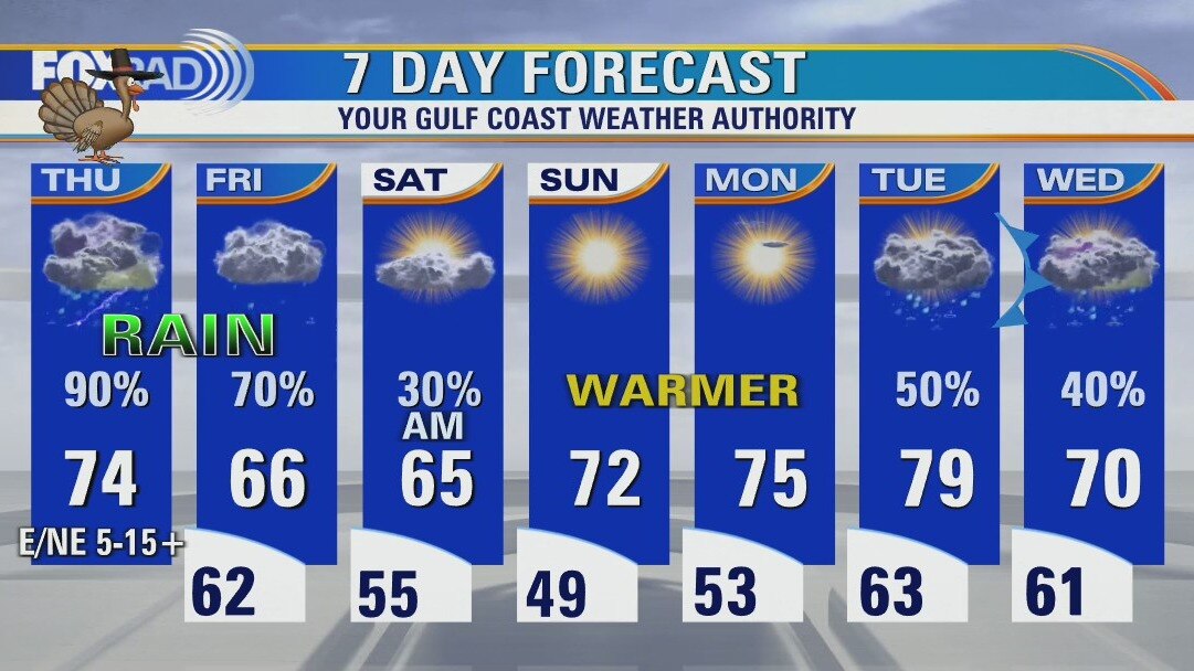
Rainy Thanksgiving forecast for Houston
If you've got last minute stuff to get done today before Thanksgiving, we're lucking out with great weather today! I wish I could say the same for tomorrow. A slow moving potent system will bring rounds of heavy rainfall, and a few stronger storms area-wide Thursday into Friday. While spotty showers may linger into the early part of Saturday, from there on out we can look forward to a few nice, sunny and dry days before our next system arrives midweek.
If you've got last minute stuff to get done today before Thanksgiving, we're lucking out with great weather today! I wish I could say the same for tomorrow. A slow moving potent system will bring rounds of heavy rainfall, and a few stronger storms area-wide Thursday into Friday. While spotty showers may linger into the early part of Saturday, from there on out we can look forward to a few nice, sunny and dry days before our next system arrives midweek.

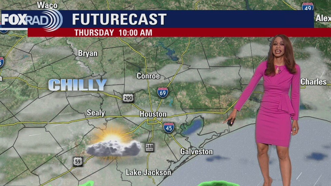
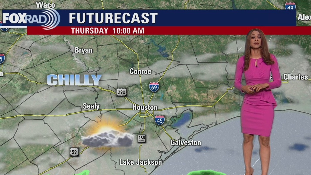
Chilly Wednesday morning, then mostly cloudy and milder
Get out and enjoy today's great weather, because Thanksgiving and Friday shopping both look rainy and at times stormy. Afternoon highs today will be the warmest in nearly two weeks as we hit the upper 60s. Locally heavy rain is possible tomorrow and Friday followed by what should be a nice weekend.
Get out and enjoy today's great weather, because Thanksgiving and Friday shopping both look rainy and at times stormy. Afternoon highs today will be the warmest in nearly two weeks as we hit the upper 60s. Locally heavy rain is possible tomorrow and Friday followed by what should be a nice weekend.

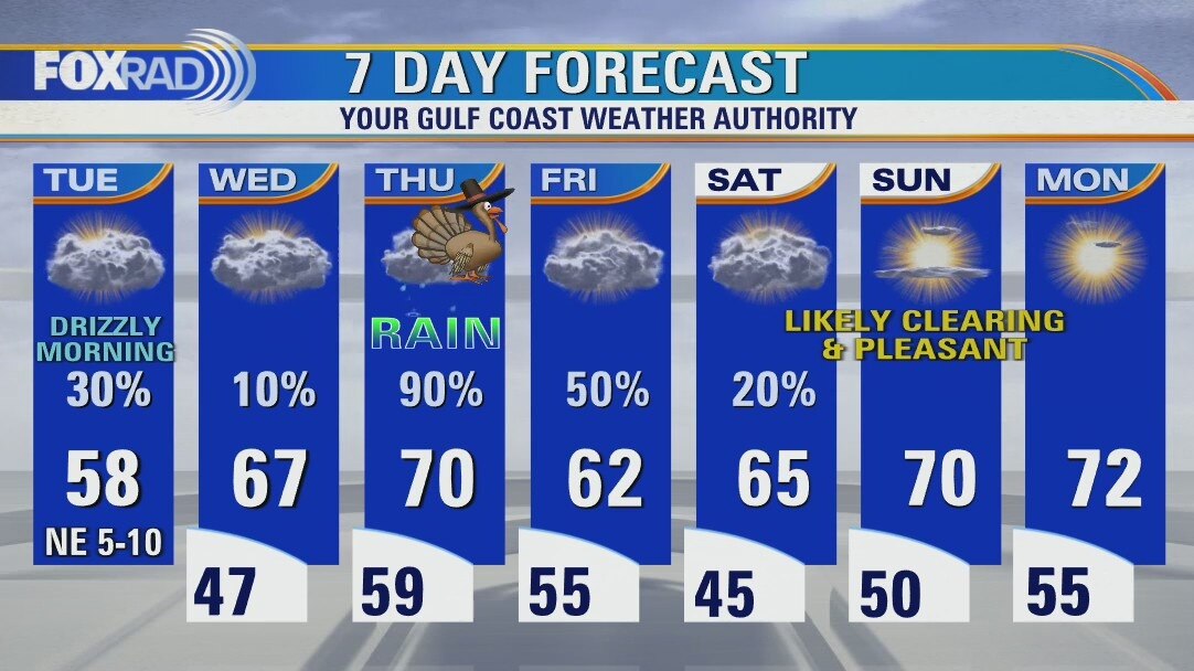
Tuesday evening weather forecast with Meteorologist Remeisha Shade
A few showers are possible tonight and again Wednesday but the majority of Wednesday should be dry. However, Thanksgiving on Thursday looks very wet with 1-2" of rain possible and even the chance for a few strong storms. Temperatures will be warmer around 70 but the rain could cause some issues for outdoor plans, including the Thanksgiving Parade in Houston. Rain lingers Friday but should finally push out as we head into the weekend.
A few showers are possible tonight and again Wednesday but the majority of Wednesday should be dry. However, Thanksgiving on Thursday looks very wet with 1-2" of rain possible and even the chance for a few strong storms. Temperatures will be warmer around 70 but the rain could cause some issues for outdoor plans, including the Thanksgiving Parade in Houston. Rain lingers Friday but should finally push out as we head into the weekend.
Chilly Tuesday morning drizzle, then cloudy and not as cold
The outlook for Thanksgiving still looks stormy with highs near 70 and even a slight chance for a strong or severe storm. Today brings more morning showers and hope for a peek of afternoon sun. Enjoy a brief day of decent weather tomorrow before the holiday rain. Showers could linger through the first half for Friday, but Saturday and Sunday are finally looking great!
The outlook for Thanksgiving still looks stormy with highs near 70 and even a slight chance for a strong or severe storm. Today brings more morning showers and hope for a peek of afternoon sun. Enjoy a brief day of decent weather tomorrow before the holiday rain. Showers could linger through the first half for Friday, but Saturday and Sunday are finally looking great!
Monday evening weather forecast with Meteorologist Remeisha Shade
It's been another soggy day across SE Texas with chilly temps in the 40s and widespread rain. Those temperatures are running about 20-25 degrees below normal for this time of the year! We finally get to enjoy some warmer weather as we move into the Thanksgiving holiday with temperatures by then near 70 degrees. Most of the rain goes away the next few days but returns for Thanksgiving day and could be heavy at times. So plan on a warmer but wet Thanksgiving with a few showers possibly lingering for Black Friday shopping as well.
It's been another soggy day across SE Texas with chilly temps in the 40s and widespread rain. Those temperatures are running about 20-25 degrees below normal for this time of the year! We finally get to enjoy some warmer weather as we move into the Thanksgiving holiday with temperatures by then near 70 degrees. Most of the rain goes away the next few days but returns for Thanksgiving day and could be heavy at times. So plan on a warmer but wet Thanksgiving with a few showers possibly lingering for Black Friday shopping as well.
Cloudy, chilly and showery with highs likely below 50 in most areas
Today will be a great day to stay in and watch the World Cup on FOX 26 because it's going to be rainy and cold again. Fortunately, we don't expect flooding, but just a steady light to moderate chilly rain through the early afternoon. We should get improving weather for Tuesday and Wednesday followed by Thanksgiving rain. "Black Friday" weather is highly uncertain at this point, but prepare for some lingering rain.
Today will be a great day to stay in and watch the World Cup on FOX 26 because it's going to be rainy and cold again. Fortunately, we don't expect flooding, but just a steady light to moderate chilly rain through the early afternoon. We should get improving weather for Tuesday and Wednesday followed by Thanksgiving rain. "Black Friday" weather is highly uncertain at this point, but prepare for some lingering rain.
More rain, chilly Sunday evening in the 50s
The weekend wraps up with more showers gradually building in associated with our next disturbance. Rain looks pretty widespread again on Monday with temperatures about 20 degrees below normal. We finally start to heat up some leading into Thanksgiving with highs near 70 Thursday. Rain chances will also return late Wednesday and stick around for Thanksgiving day. Late week the pattern looks to shift with more sun and drier weather building in.
The weekend wraps up with more showers gradually building in associated with our next disturbance. Rain looks pretty widespread again on Monday with temperatures about 20 degrees below normal. We finally start to heat up some leading into Thanksgiving with highs near 70 Thursday. Rain chances will also return late Wednesday and stick around for Thanksgiving day. Late week the pattern looks to shift with more sun and drier weather building in.

Sunday weather forecast with Meteorolgist Lena Maria Arango
The weekend ends cool and cloudy but it will certainly be an improvement from yesterday! We've got another round of cold rain to deal with at the start of the workweek, though coverage and intensity look to be a bit less than Saturday. The rest of the week looks milder, with some question marks on the details for Thanksgiving rain. But do plan for some form of unsettled weather late Wednesday into Thursday, with a drying trend to follow for shopping, the weekend, and return travel post-holiday!
The weekend ends cool and cloudy but it will certainly be an improvement from yesterday! We've got another round of cold rain to deal with at the start of the workweek, though coverage and intensity look to be a bit less than Saturday. The rest of the week looks milder, with some question marks on the details for Thanksgiving rain. But do plan for some form of unsettled weather late Wednesday into Thursday, with a drying trend to follow for shopping, the weekend, and return travel post-holiday!
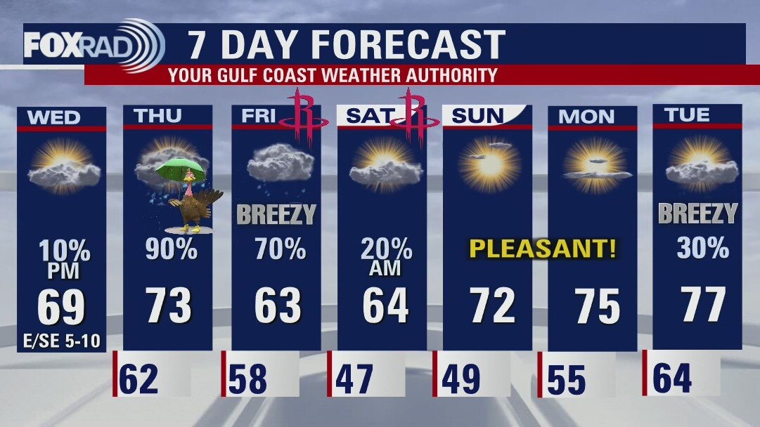
Chilly, rainy, breezy this Saturday evening in the 40s
It's been a super soggy, chilly & breezy Saturday. But Sunday looks a little better. Rain should wind down late tonight with just a few showers expected Sunday. Look for another round of rain to push in for much of Monday. Then a few more showers are possible for the big travel day on Wednesday and Thanksgiving. At least the weather pattern finally looks drier and brighter for all the black Friday shoppers next week.
It's been a super soggy, chilly & breezy Saturday. But Sunday looks a little better. Rain should wind down late tonight with just a few showers expected Sunday. Look for another round of rain to push in for much of Monday. Then a few more showers are possible for the big travel day on Wednesday and Thanksgiving. At least the weather pattern finally looks drier and brighter for all the black Friday shoppers next week.

Saturday weather forecast with Meteorologist Lena Maria Arango
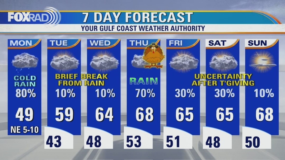
A cold, steady rain will be in place for much of the day Saturday with falling temps. A Wind Advisory is in effect through 9 a.m. Sunday along the coast and gusty north winds will make it feel colder than it already is. Sunday looks mostly dry, but also mostly cloudy. A few light and spotty showers may creep back in later in the day as our next rain event approaches Monday. Continuing to keep a close eye on Thanksgiving locally, which is still several days away so expect changes in the forecast. But as of right now, there are some shower chances that look to be mostly Wednesday night into the earlier part of Thursday. Temperatures at least will be trending a bit milder for the holiday!
A cold, steady rain will be in place for much of the day Saturday with falling temps. A Wind Advisory is in effect through 9 a.m. Sunday along the coast and gusty north winds will make it feel colder than it already is. Sunday looks mostly dry, but also mostly cloudy. A few light and spotty showers may creep back in later in the day as our next rain event approaches Monday. Continuing to keep a close eye on Thanksgiving locally, which is still several days away so expect changes in the forecast. But as of right now, there are some shower chances that look to be mostly Wednesday night into the earlier part of Thursday. Temperatures at least will be trending a bit milder for the holiday!
Mostly cloudy & cool Friday with a few showers possible
The weekend will be sandwiched in by two separate rounds of rain, with cloudy and cool conditions persisting for much of the next week. Sunday is your better bet for errands and outdoor activities. We?ll ?warm? slightly as we head toward Thanksgiving, though our unsettled pattern looks to remain in place for now.
The weekend will be sandwiched in by two separate rounds of rain, with cloudy and cool conditions persisting for much of the next week. Sunday is your better bet for errands and outdoor activities. We?ll ?warm? slightly as we head toward Thanksgiving, though our unsettled pattern looks to remain in place for now.
Friday morning weather forecast
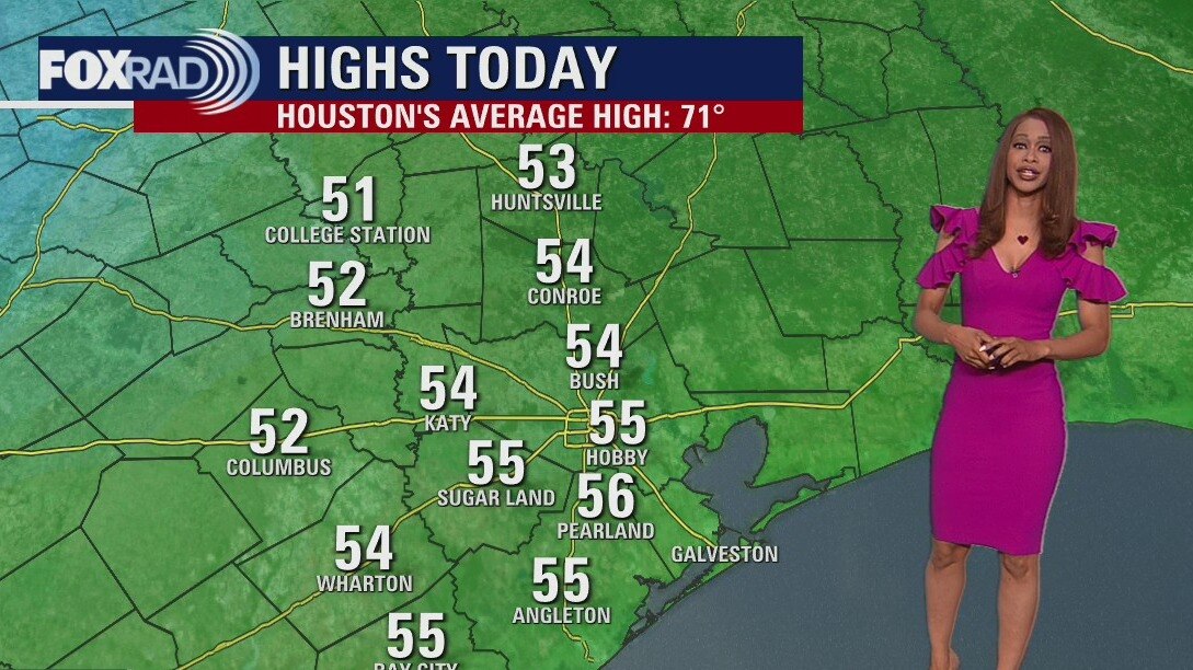
Things are looking pretty chilly for Houston and the rest of SE Texas through the rest of the work week and into the weekend. High temperatures will remain in the 50s through the weekend with overnight lows in the 30s and 40s. Look for a few showers late on Friday but widespread rain is expected for Saturday. Sunday will only bring isolated rain but showers increase again on Monday. Few showers are possible for Thanksgiving but at least it will be a bit warmer with high temperatures near 70!
Things are looking pretty chilly for Houston and the rest of SE Texas through the rest of the work week and into the weekend. High temperatures will remain in the 50s through the weekend with overnight lows in the 30s and 40s. Look for a few showers late on Friday but widespread rain is expected for Saturday. Sunday will only bring isolated rain but showers increase again on Monday. Few showers are possible for Thanksgiving but at least it will be a bit warmer with high temperatures near 70!

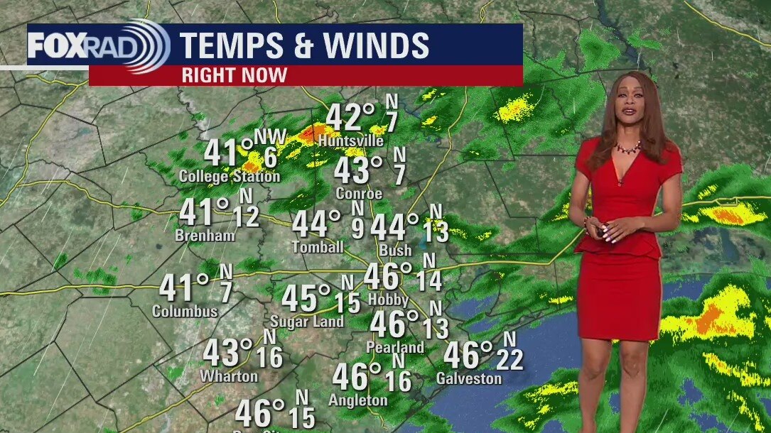
Chilly morning, then partly cloudy and cool with scattered showers south
If you want warm air any time soon, you'll have to find it indoors, because we are still locked into a chilly, mostly cloudy pattern. Watch for isolated drizzles today and Friday with a disturbance bringing a wet, cold and breezy Saturday. Sunday looks like the better day to plan anything outdoors. We'll remain unsettled heading into Thanksgiving, but with slightly milder air.
If you want warm air any time soon, you'll have to find it indoors, because we are still locked into a chilly, mostly cloudy pattern. Watch for isolated drizzles today and Friday with a disturbance bringing a wet, cold and breezy Saturday. Sunday looks like the better day to plan anything outdoors. We'll remain unsettled heading into Thanksgiving, but with slightly milder air.
Thursday morning weather forecast
Unseasonably cool weather will stick around through early next week with high temperatures in the 50s and overnight lows in the 30s and 40s. Next big round of rain is expected Saturday with a coastal low. Look for a nice warming trend just in time for Thanksgiving!
Unseasonably cool weather will stick around through early next week with high temperatures in the 50s and overnight lows in the 30s and 40s. Next big round of rain is expected Saturday with a coastal low. Look for a nice warming trend just in time for Thanksgiving!
Breezy, chilly Wednesday evening in the 50s
Unseasonably cool weather will stick around through early next week with high temperatures in the 50s and overnight lows in the 30s and 40s. Next big round of rain is expected Saturday with a coastal low. Look for a nice warming trend just in time for Thanksgiving!
Unseasonably cool weather will stick around through early next week with high temperatures in the 50s and overnight lows in the 30s and 40s. Next big round of rain is expected Saturday with a coastal low. Look for a nice warming trend just in time for Thanksgiving!