

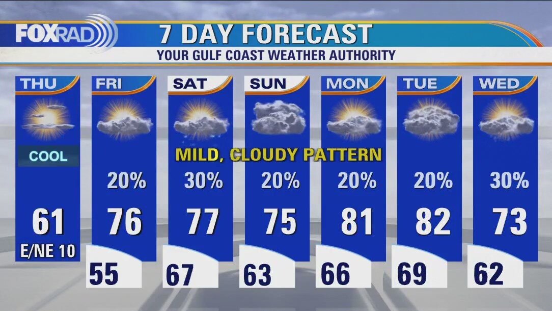
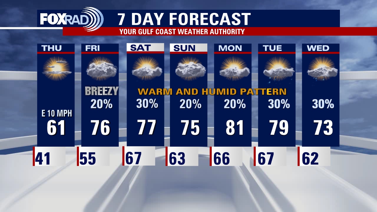
Cool, crisp Thursday afternoon in the 60s
If you're a fan of cooler weather, enjoy it today because our burst of crisp winter air was short-lived. Winds off the gulf will feed in warmer, humid air beginning tomorrow through much of next week. Expect partly to mostly cloudy skies, with a few light and spotty showers due to the increase in humidity. Patchy morning fog will also be something to be on the lookout for. Eyeing the possibility of our next front middle of next week, which would break us out of this steamy pattern.
If you're a fan of cooler weather, enjoy it today because our burst of crisp winter air was short-lived. Winds off the gulf will feed in warmer, humid air beginning tomorrow through much of next week. Expect partly to mostly cloudy skies, with a few light and spotty showers due to the increase in humidity. Patchy morning fog will also be something to be on the lookout for. Eyeing the possibility of our next front middle of next week, which would break us out of this steamy pattern.
Thursday weather forecast
Grab a jacket today, because after a cold morning, high temperatures will be stuck in the low 60s. Other than the cool air, today will be quiet. Clouds and milder air start to return tonight as we enter a stretch of warmer, cloudy and drippy weather for the next week or so.
Grab a jacket today, because after a cold morning, high temperatures will be stuck in the low 60s. Other than the cool air, today will be quiet. Clouds and milder air start to return tonight as we enter a stretch of warmer, cloudy and drippy weather for the next week or so.
Wednesday evening weather forecast with Meteorologist Remeisha Shade
It's been a bright and beautiful day but a windy one with gusts near 30 mph still possible through early evening. Wind settles down tonight as high pressure builds in allowing those temperatures to tumble into the 30s and 40s. Look for some clouds to return Thursday with isolated rain possible Friday. There's a big jump in temperatures right around the corner with highs near 80 going into the weekend! Slim shot for rain will stick around through the middle of next week with more warm temperatures for December.
It's been a bright and beautiful day but a windy one with gusts near 30 mph still possible through early evening. Wind settles down tonight as high pressure builds in allowing those temperatures to tumble into the 30s and 40s. Look for some clouds to return Thursday with isolated rain possible Friday. There's a big jump in temperatures right around the corner with highs near 80 going into the weekend! Slim shot for rain will stick around through the middle of next week with more warm temperatures for December.
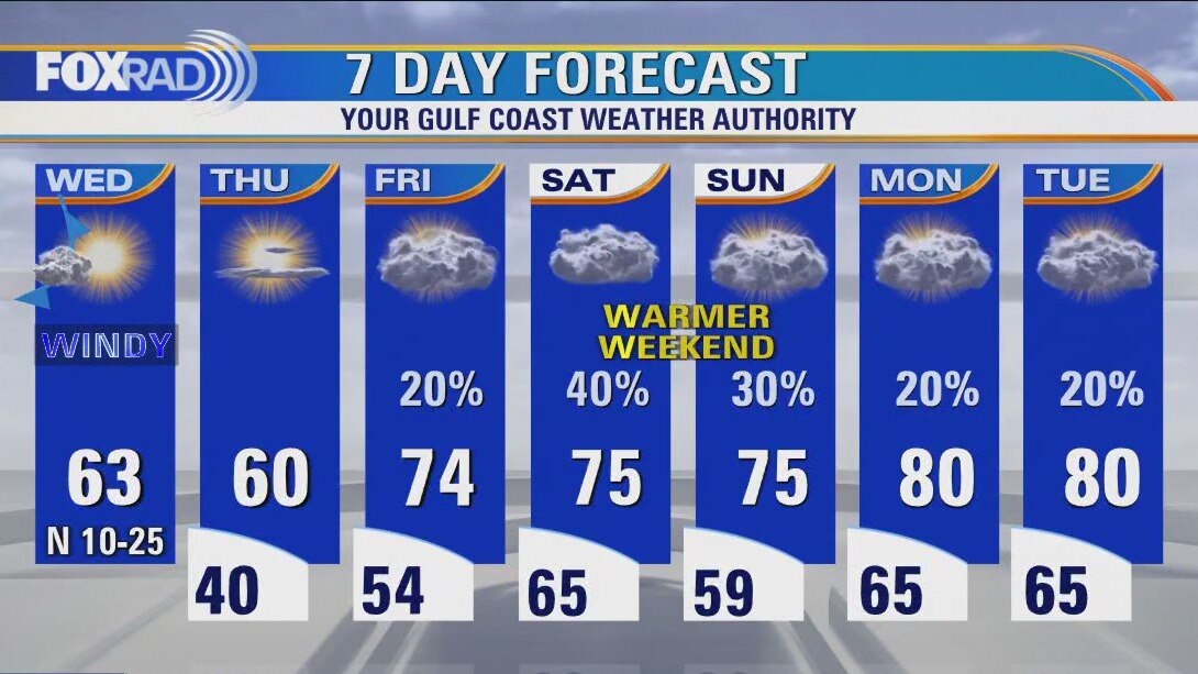
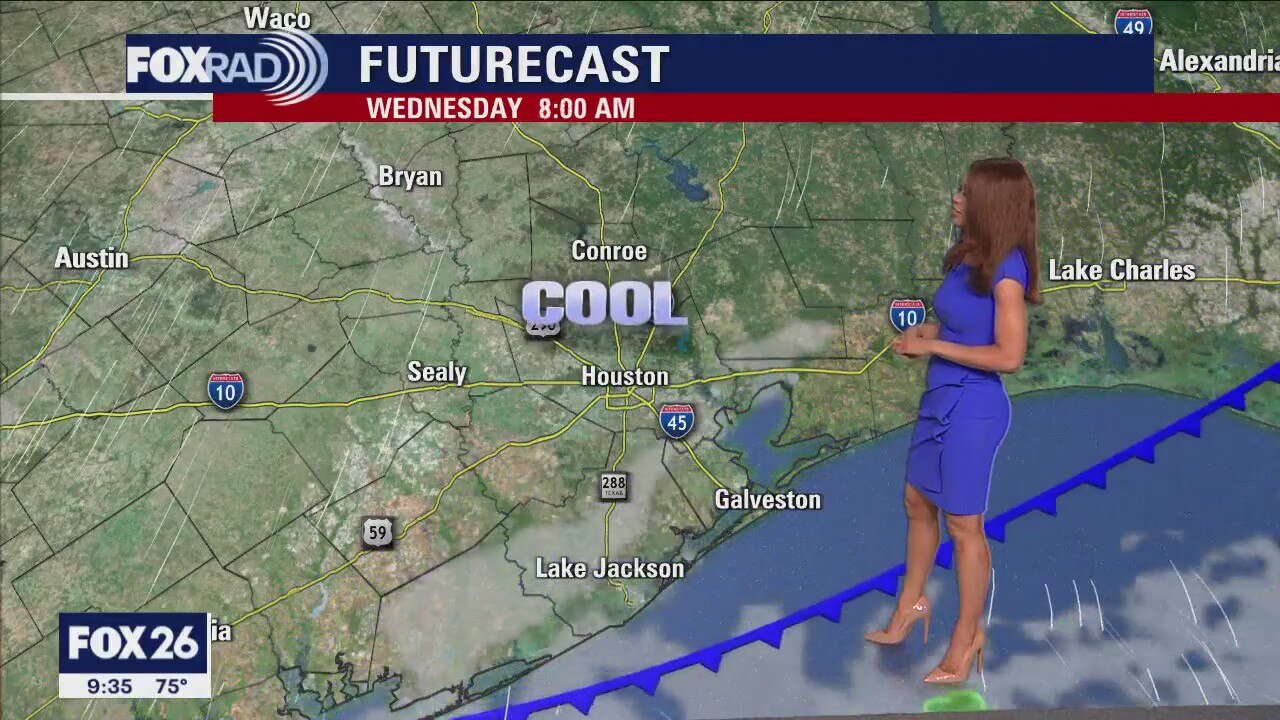
Expect a cool, windy Wednesday afternoon in the 60s
Our cold front has cleared the coast, and as drier, cooler air drains in we'll be a bit on the windy side. Winds will relax in the overnight hours and for tomorrow but the cool air won't last long. Gulf breezes return on Friday, and that southerly flow brings the warm and humid train rolling right back into the station. This will keep us partly to mostly cloudy and showery through the beginning of next week, with our next front possibly bringing a switch-up by Wednesday.
Our cold front has cleared the coast, and as drier, cooler air drains in we'll be a bit on the windy side. Winds will relax in the overnight hours and for tomorrow but the cool air won't last long. Gulf breezes return on Friday, and that southerly flow brings the warm and humid train rolling right back into the station. This will keep us partly to mostly cloudy and showery through the beginning of next week, with our next front possibly bringing a switch-up by Wednesday.
Windy, sunny, chilly Wednesday in Houston
A cold front will bring windy, chilly, sunny and dry weather today. A wind advisory is in effect for Galveston Island and the coast of Brazoria County until 3 p.m. Otherwise, look for a clear, cold night today (above freezing), then a mostly cloudy, mild and sometimes drizzly pattern into the weekend.
A cold front will bring windy, chilly, sunny and dry weather today. A wind advisory is in effect for Galveston Island and the coast of Brazoria County until 3 p.m. Otherwise, look for a clear, cold night today (above freezing), then a mostly cloudy, mild and sometimes drizzly pattern into the weekend.
Wednesday morning weather forecast
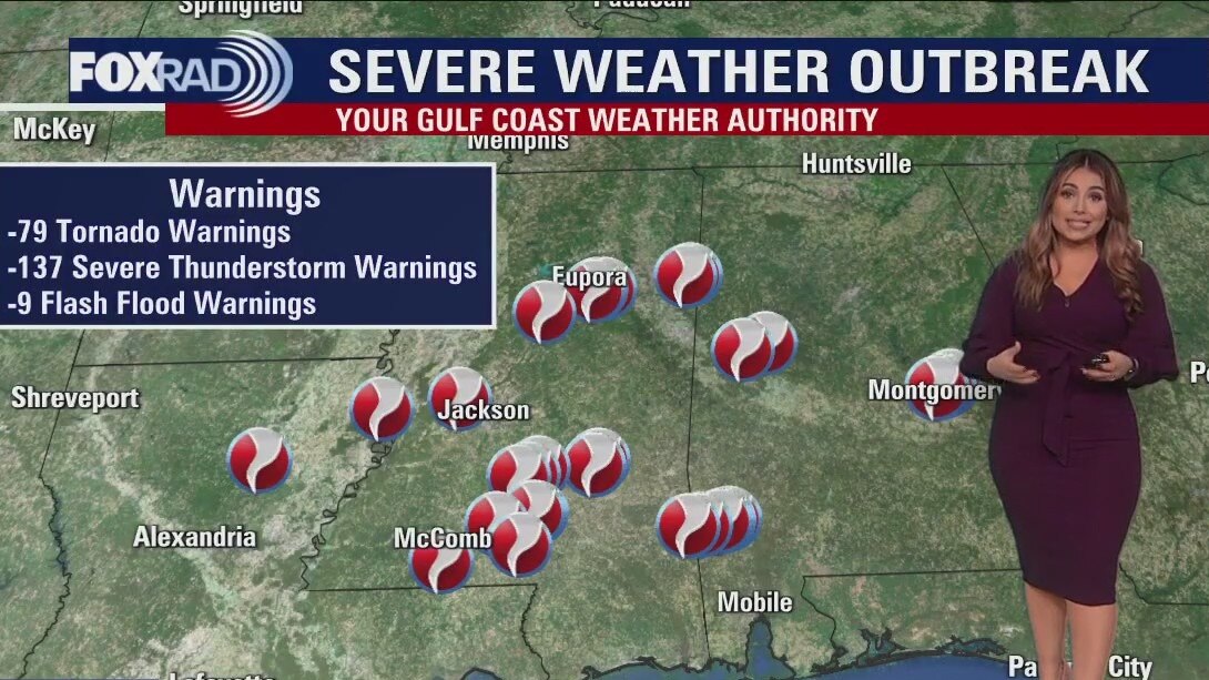
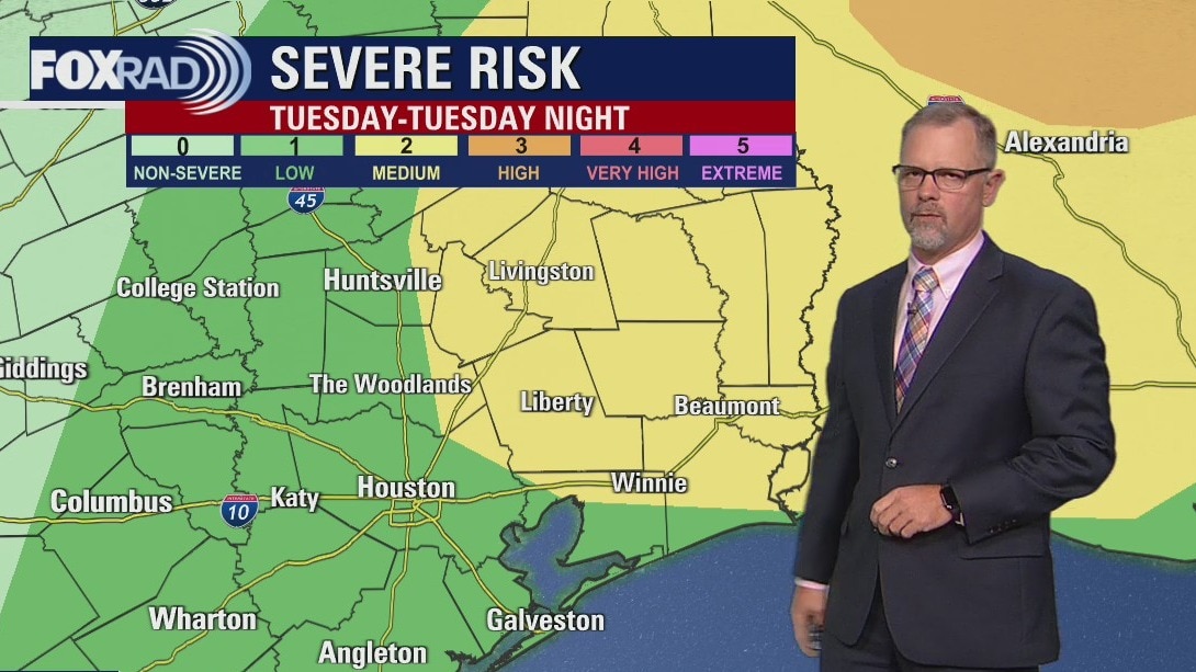
Severe threat should stay to our E/NE across Louisiana, Mississippi, Alabama & Arkansas where a big tornado outbreak is expected to continue through tonight ahead of a cold front. That same cold front will arrive early Wednesday morning bringing a few more showers. Behind the front, we quickly dry out and it turns breezy with gusts near 30 mph. Much cooler air will stick with us for a few days before a nice warming trend heading into the weekend. A few rain showers may impact your weekend plans.
Severe threat should stay to our E/NE across Louisiana, Mississippi, Alabama & Arkansas where a big tornado outbreak is expected to continue through tonight ahead of a cold front. That same cold front will arrive early Wednesday morning bringing a few more showers. Behind the front, we quickly dry out and it turns breezy with gusts near 30 mph. Much cooler air will stick with us for a few days before a nice warming trend heading into the weekend. A few rain showers may impact your weekend plans.

Tuesday evening weather forecast with Meteorologist Remeisha Shade
Severe threat should stay to our E/NE across Louisiana, Mississippi, Alabama & Arkansas where a big tornado outbreak is expected to continue through tonight ahead of a cold front. That same cold front will arrive early Wednesday morning bringing a few more showers. Behind the front, we quickly dry out and it turns breezy with gusts near 30 mph. Much cooler air will stick with us for a few days before a nice warming trend heading into the weekend. A few rain showers may impact your weekend plans.
Severe threat should stay to our E/NE across Louisiana, Mississippi, Alabama & Arkansas where a big tornado outbreak is expected to continue through tonight ahead of a cold front. That same cold front will arrive early Wednesday morning bringing a few more showers. Behind the front, we quickly dry out and it turns breezy with gusts near 30 mph. Much cooler air will stick with us for a few days before a nice warming trend heading into the weekend. A few rain showers may impact your weekend plans.
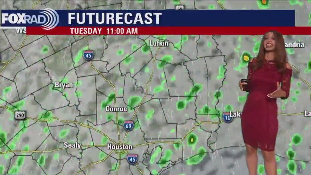
Rain in the forecast for Tuesday
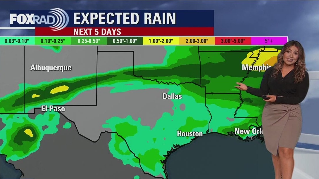
This week is a bit of a weather roller-coaster with this morning's temperatures running 25 degrees warmer than Monday's. This additional warm, humid air will bring scattered showers and some afternoon storms with a few strong ones mainly east of Houston. Today is expected to be particularly dangerous across Louisiana and Mississippi with a risk for tornadoes. Tomorrow morning a cold front will bring cooler and drier north winds followed by a chilly Thursday morning. A warming trend takes us into the weekend.
This week is a bit of a weather roller-coaster with this morning's temperatures running 25 degrees warmer than Monday's. This additional warm, humid air will bring scattered showers and some afternoon storms with a few strong ones mainly east of Houston. Today is expected to be particularly dangerous across Louisiana and Mississippi with a risk for tornadoes. Tomorrow morning a cold front will bring cooler and drier north winds followed by a chilly Thursday morning. A warming trend takes us into the weekend.
Tuesday morning weather forecast
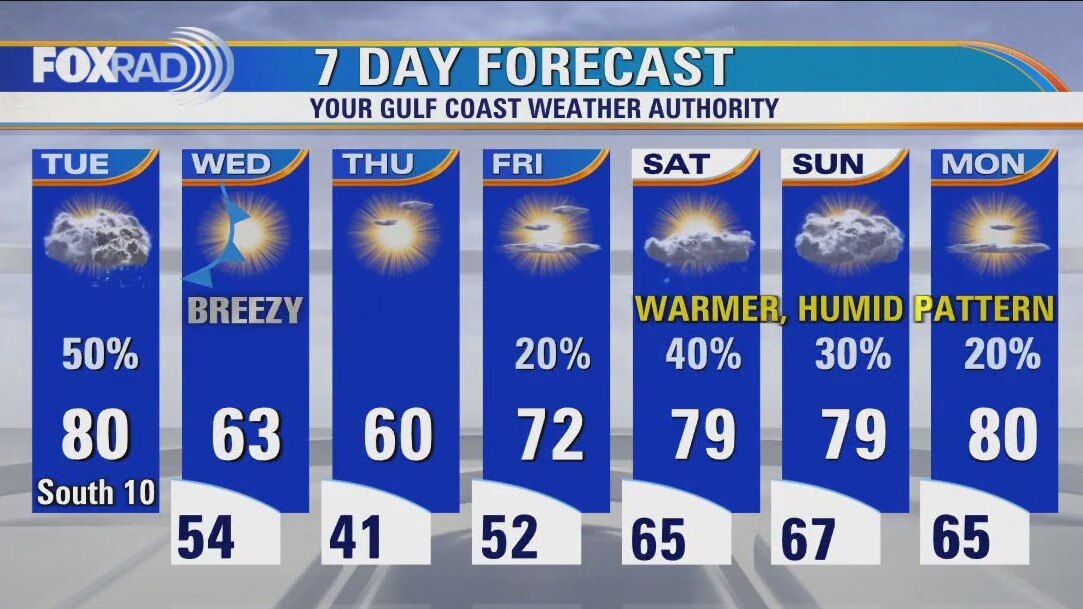
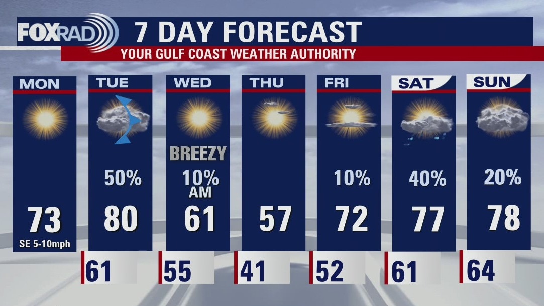
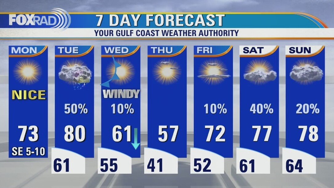
What a picture perfect start to the new week after a long holiday weekend! Changes are right around the corner though as another cold front comes rolling in late Tuesday and early Wednesday. Ahead of this front, a significant severe weather outbreak is expected across parts of the Mississippi River Valley & TN Valley with a tornado outbreak possible Tuesday PM. We are on the edge of this severe threat with a Category 1 Marginal Severe Threat for the Houston area. That mean 1 or 2 storms could become severe Tuesday PM with the best chance in the eastern counties. Expect about a 20 degree temperature drop Wednesday with breezy conditions behind the front.
What a picture perfect start to the new week after a long holiday weekend! Changes are right around the corner though as another cold front comes rolling in late Tuesday and early Wednesday. Ahead of this front, a significant severe weather outbreak is expected across parts of the Mississippi River Valley & TN Valley with a tornado outbreak possible Tuesday PM. We are on the edge of this severe threat with a Category 1 Marginal Severe Threat for the Houston area. That mean 1 or 2 storms could become severe Tuesday PM with the best chance in the eastern counties. Expect about a 20 degree temperature drop Wednesday with breezy conditions behind the front.

Monday evening weather forecast with Meteorologist Remeisha Shade
What a picture-perfect start to the new week after a long holiday weekend! Changes are right around the corner though as another cold front comes rolling in late Tuesday and early Wednesday. Ahead of this front, a significant severe weather outbreak is expected across parts of the Mississippi River Valley & TN Valley with a tornado outbreak possible Tuesday PM. We are on the edge of this severe threat with a Category 1 Marginal Severe Threat for the Houston area. That means 1 or 2 storms could become severe Tuesday PM with the best chance in the eastern counties. Expect about a 20-degree temperature drop Wednesday with breezy conditions behind the front.
What a picture-perfect start to the new week after a long holiday weekend! Changes are right around the corner though as another cold front comes rolling in late Tuesday and early Wednesday. Ahead of this front, a significant severe weather outbreak is expected across parts of the Mississippi River Valley & TN Valley with a tornado outbreak possible Tuesday PM. We are on the edge of this severe threat with a Category 1 Marginal Severe Threat for the Houston area. That means 1 or 2 storms could become severe Tuesday PM with the best chance in the eastern counties. Expect about a 20-degree temperature drop Wednesday with breezy conditions behind the front.
Monday afternoon weather with Meteorolgist John Dawson
Today is going to be a beauty, so enjoy. Expect sunshine and a quiet, mild afternoon. Tomorrow is going to be an active day to our northeast with severe storms and tornadoes likely in Louisiana, Mississippi, Tennessee, and parts of nearby states. Locally, scattered showers and storms are expected with a few becoming strong mainly northeast of Houston. A cold front will bring chilly and windy conditions Wednesday with late-week weather shaping up nicely.
Today is going to be a beauty, so enjoy. Expect sunshine and a quiet, mild afternoon. Tomorrow is going to be an active day to our northeast with severe storms and tornadoes likely in Louisiana, Mississippi, Tennessee, and parts of nearby states. Locally, scattered showers and storms are expected with a few becoming strong mainly northeast of Houston. A cold front will bring chilly and windy conditions Wednesday with late-week weather shaping up nicely.
Chilly with patchy fog Monday morning, then sunny
Today is going to be a beauty, so enjoy. Expect sunshine and a quiet, mild afternoon. Tomorrow is going to be an active day to our northeast with severe storms and tornadoes likely in Louisiana, Mississippi, Tennessee and parts of nearby states. Locally, scattered showers and storms are expected with a few becoming strong mainly northeast of Houston. A cold front will bring chilly and windy conditions Wednesday with late-week weather shaping up nicely.
Today is going to be a beauty, so enjoy. Expect sunshine and a quiet, mild afternoon. Tomorrow is going to be an active day to our northeast with severe storms and tornadoes likely in Louisiana, Mississippi, Tennessee and parts of nearby states. Locally, scattered showers and storms are expected with a few becoming strong mainly northeast of Houston. A cold front will bring chilly and windy conditions Wednesday with late-week weather shaping up nicely.
Warm, calm winds Sunday evening in the 70s
If you liked the weather on Sunday, good news cause Monday looks to be almost identical. Houston will start off cool with morning lows in the upper 40s and afternoon highs in the lower 70s. The next major storm system for the US will impact southeast Texas on Tuesday. This system will cause severe storms for other parts of the country but Houston should only see isolated strong storms. We end the week quiet with rain chances returning for the weekend.
If you liked the weather on Sunday, good news cause Monday looks to be almost identical. Houston will start off cool with morning lows in the upper 40s and afternoon highs in the lower 70s. The next major storm system for the US will impact southeast Texas on Tuesday. This system will cause severe storms for other parts of the country but Houston should only see isolated strong storms. We end the week quiet with rain chances returning for the weekend.
Sunday weather forecast with Meteorologist Lena Maria
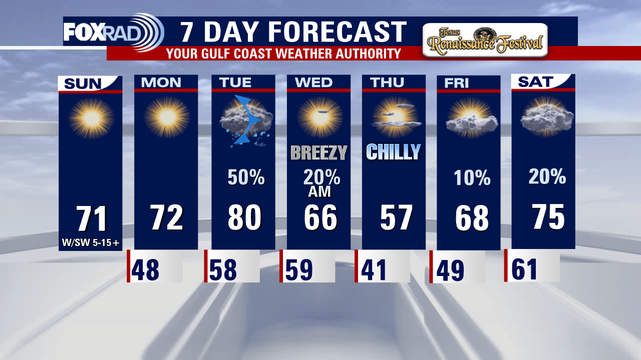
It's the last day of Ren Fest and the weather is fantastic for it. Soak in these next few days of sunshine, because this week will be a bit of a rollercoaster. We'll warm to near 80 as storms roll in on Tuesday, some of which could be strong to severe. Then a surge of dry, cool air temporarily rushes in leading to a 20+ degree drop in highs/lows. Thursday many may not make it out of the 50s, but warming quickly returns into the weekend with the possibility of a few isolated showers.
It's the last day of Ren Fest and the weather is fantastic for it. Soak in these next few days of sunshine, because this week will be a bit of a rollercoaster. We'll warm to near 80 as storms roll in on Tuesday, some of which could be strong to severe. Then a surge of dry, cool air temporarily rushes in leading to a 20+ degree drop in highs/lows. Thursday many may not make it out of the 50s, but warming quickly returns into the weekend with the possibility of a few isolated showers.
Windy, cool Saturday evening in the low 60s
Look for quiet weather here in Southeast Texas for the next couple of days. The afternoon highs will be seasonally on track for Houston. The mornings will be cool with lows in the upper 40s. The next big storm system to move across the US could bring severe storms to the Ark-La-Miss region on Tuesday but could send stormy weather our way as well. The cooldown from that front will be brief with more rain possible headed into next weekend.
Look for quiet weather here in Southeast Texas for the next couple of days. The afternoon highs will be seasonally on track for Houston. The mornings will be cool with lows in the upper 40s. The next big storm system to move across the US could bring severe storms to the Ark-La-Miss region on Tuesday but could send stormy weather our way as well. The cooldown from that front will be brief with more rain possible headed into next weekend.

Saturday weather forecast with Meteorologist Lena Maria Arango
Heavy rain remains possible through mid-morning, then skies will clear but it will be gusty this afternoon. We've got a few days of quiet weather to look forward to before our next storm system, which looks to bring severe weather to the Ark-La-Miss region on Tuesday but could extend back our way as well. Rains from that look to wrap up early Wednesday, followed by a brief cool down. A few showers may return as we head into the weekend.
Heavy rain remains possible through mid-morning, then skies will clear but it will be gusty this afternoon. We've got a few days of quiet weather to look forward to before our next storm system, which looks to bring severe weather to the Ark-La-Miss region on Tuesday but could extend back our way as well. Rains from that look to wrap up early Wednesday, followed by a brief cool down. A few showers may return as we head into the weekend.

Saturday morning weather forecast with Meteorologist Lena Maria Arango
Heavy rain remains possible through mid-morning, then skies will clear but it will be gusty this afternoon. We've got a few days of quiet weather to look forward to before our next storm system, which looks to bring severe weather to the Ark-La-Miss region on Tuesday but could extend back our way as well. Rains from that look to wrap up early Wednesday, followed by a brief cool down. A few showers may return as we head into the weekend.
Heavy rain remains possible through mid-morning, then skies will clear but it will be gusty this afternoon. We've got a few days of quiet weather to look forward to before our next storm system, which looks to bring severe weather to the Ark-La-Miss region on Tuesday but could extend back our way as well. Rains from that look to wrap up early Wednesday, followed by a brief cool down. A few showers may return as we head into the weekend.


Flood watch through Noon Saturday in Houston
Widespread showers and scattered heavy downpours will move across Southeast Texas through the Friday overnight hours and into Saturday morning. The FLOOD WATCH for most of the Houston area runs until Noon on Saturday. Expect the skies to clear on Saturday afternoon and very pleasant days on Sunday and Monday. The next front will arrive late Tuesday into early Wednesday bringing another round of rain and cooler temperatures.
Widespread showers and scattered heavy downpours will move across Southeast Texas through the Friday overnight hours and into Saturday morning. The FLOOD WATCH for most of the Houston area runs until Noon on Saturday. Expect the skies to clear on Saturday afternoon and very pleasant days on Sunday and Monday. The next front will arrive late Tuesday into early Wednesday bringing another round of rain and cooler temperatures.

Flood watch through Saturday afternoon in Houston
Widespread showers and scattered heavy downpours will move across Southeast Texas through the Friday overnight hours and into Saturday morning. The FLOOD WATCH for most of the Houston area runs until Noon on Saturday. Expect the skies to clear on Saturday afternoon and very pleasant days on Sunday and Monday. The next front will arrive late Tuesday into early Wednesday bringing another round of rain and cooler temperatures.
Widespread showers and scattered heavy downpours will move across Southeast Texas through the Friday overnight hours and into Saturday morning. The FLOOD WATCH for most of the Houston area runs until Noon on Saturday. Expect the skies to clear on Saturday afternoon and very pleasant days on Sunday and Monday. The next front will arrive late Tuesday into early Wednesday bringing another round of rain and cooler temperatures.

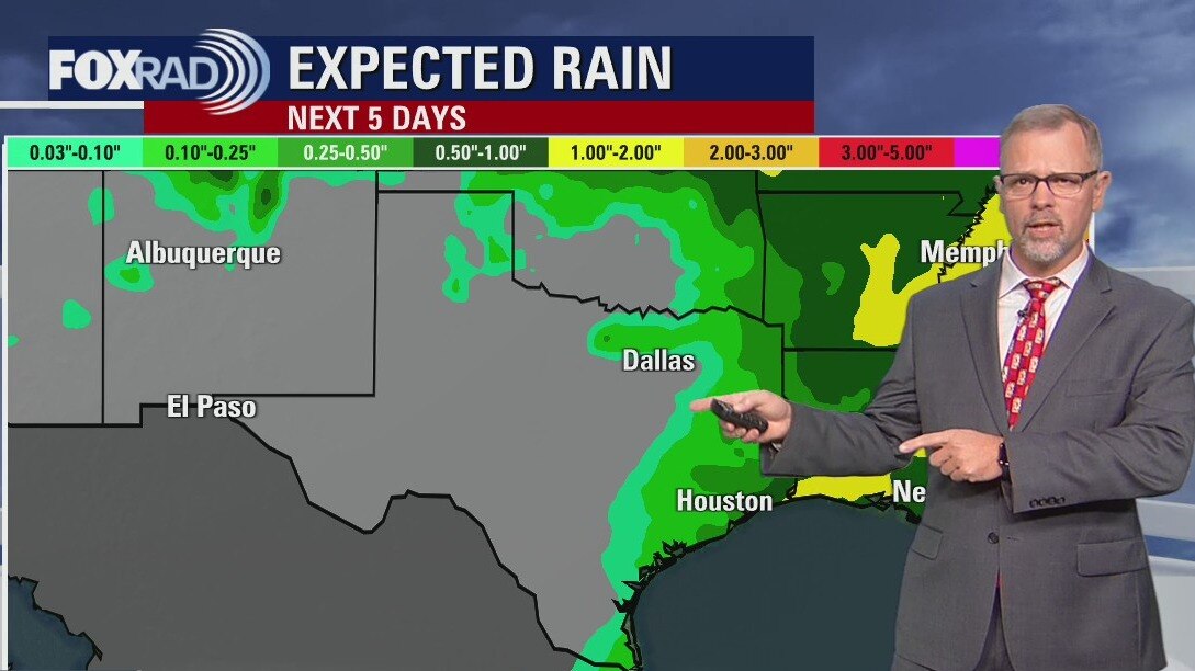
Rain and storms Friday afternoon, evening
Rain and storms will ramp up this afternoon and evening, and linger into the early part of the day on Saturday. A few stronger storms are possible along the coastline, in addition to an area wide flood risk that extends through midday tomorrow. Conditions will rapidly improve with sunshine returning by Saturday afternoon, with a few days of dry weather before our next system. Things could get messy again with the potential for a stronger front on Tuesday, so stay tuned for details on that.
Rain and storms will ramp up this afternoon and evening, and linger into the early part of the day on Saturday. A few stronger storms are possible along the coastline, in addition to an area wide flood risk that extends through midday tomorrow. Conditions will rapidly improve with sunshine returning by Saturday afternoon, with a few days of dry weather before our next system. Things could get messy again with the potential for a stronger front on Tuesday, so stay tuned for details on that.