


FOX 26 Houston Weather Forecast
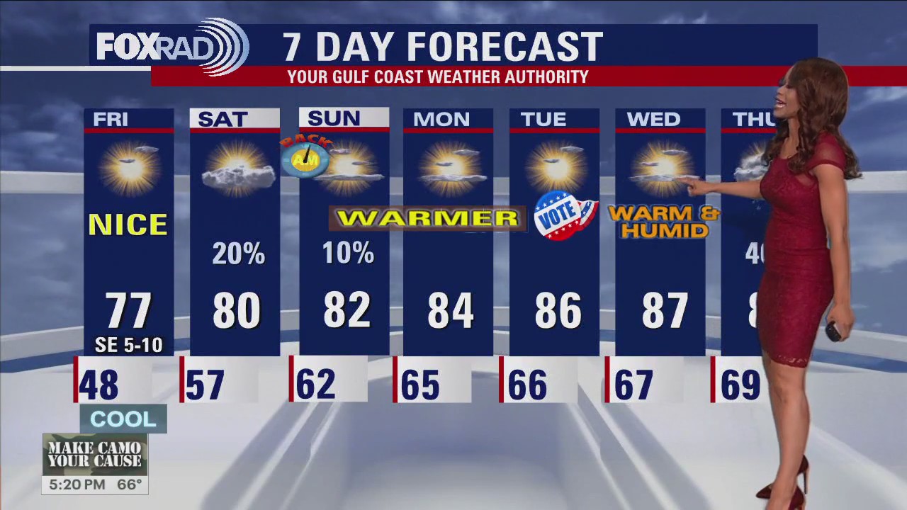
Today's weather has been about as close to perfect as you can get...that is if you like pleasant temperatures, sunny skies and light wind. It will be cool tonight in the upper 50s but nothing too extreme. You may want to grab a light jacket for Friday night plans. Warming trend kicks into high gear over the coming days with highs in the low 80s this weekend. There will be a slim chance for for a few showers this weekend with the best chance coming Saturday PM (20%). Next week, humidity really starts to build in and the temperatures will soar close to 90 by the middle of the week! If you are hoping for fall weather to return, then you will like what's coming late next week. Next cold front builds in Thursday evening into early Friday bringing decent rain chances and ushering in cooler air. Have a great weekend!
Today's weather has been about as close to perfect as you can get...that is if you like pleasant temperatures, sunny skies and light wind. It will be cool tonight in the upper 50s but nothing too extreme. You may want to grab a light jacket for Friday night plans. Warming trend kicks into high gear over the coming days with highs in the low 80s this weekend. There will be a slim chance for for a few showers this weekend with the best chance coming Saturday PM (20%). Next week, humidity really starts to build in and the temperatures will soar close to 90 by the middle of the week! If you are hoping for fall weather to return, then you will like what's coming late next week. Next cold front builds in Thursday evening into early Friday bringing decent rain chances and ushering in cooler air. Have a great weekend!


FOX 26 Houston Weather Forecast
Today's weather has been about as close to perfect as you can get...that is if you like pleasant temperatures, sunny skies and light wind. It will be cool tonight in the upper 50s but nothing too extreme. You may want to grab a light jacket for Friday night plans. Warming trend kicks into high gear over the coming days with highs in the low 80s this weekend. There will be a slim chance for for a few showers this weekend with the best chance coming Saturday PM (20%). Next week, humidity really starts to build in and the temperatures will soar close to 90 by the middle of the week! If you are hoping for fall weather to return, then you will like what's coming late next week. Next cold front builds in Thursday evening into early Friday bringing decent rain chances and ushering in cooler air. Have a great weekend!
Today's weather has been about as close to perfect as you can get...that is if you like pleasant temperatures, sunny skies and light wind. It will be cool tonight in the upper 50s but nothing too extreme. You may want to grab a light jacket for Friday night plans. Warming trend kicks into high gear over the coming days with highs in the low 80s this weekend. There will be a slim chance for for a few showers this weekend with the best chance coming Saturday PM (20%). Next week, humidity really starts to build in and the temperatures will soar close to 90 by the middle of the week! If you are hoping for fall weather to return, then you will like what's coming late next week. Next cold front builds in Thursday evening into early Friday bringing decent rain chances and ushering in cooler air. Have a great weekend!


FOX 26 Houston Weather Forecast
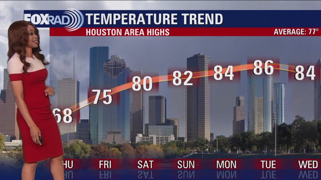
Houston ends the work week and starts the weekend with mostly sunny skies and temperatures in the upper 70s. Look for the return of the 80s on Saturday and Sunday with the addition of some isolated showers. Most likely any rain will stay close to the coast. Temperatures climb close to 90 before the next cold front arrives to southeast Texas at the end of next week.
Houston ends the work week and starts the weekend with mostly sunny skies and temperatures in the upper 70s. Look for the return of the 80s on Saturday and Sunday with the addition of some isolated showers. Most likely any rain will stay close to the coast. Temperatures climb close to 90 before the next cold front arrives to southeast Texas at the end of next week.


FOX 26 Houston Weather Forecast
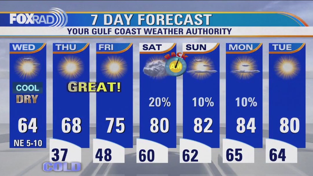
After the coldest morning of the season so far, get ready for another big weather pattern change! We made it down to 37 at Bush Airport and 31 in Conroe this morning! But we'll go from winter back to the 80s in just a few days! Tonight will be cool but not as cold with temperature in the upper 40s for Houston. Mostly sunny skies and temperatures in the upper 70s are expected Friday afternoon. Low 80s are expected Saturday and Sunday afternoon with only a slim chance for an isolated shower. You will really feel that humidity building next week along with more heat with temperatures back close to 90 by Wednesday. Our next decent chance for rain is about a week from now with our next cold front Thursday evening.
After the coldest morning of the season so far, get ready for another big weather pattern change! We made it down to 37 at Bush Airport and 31 in Conroe this morning! But we'll go from winter back to the 80s in just a few days! Tonight will be cool but not as cold with temperature in the upper 40s for Houston. Mostly sunny skies and temperatures in the upper 70s are expected Friday afternoon. Low 80s are expected Saturday and Sunday afternoon with only a slim chance for an isolated shower. You will really feel that humidity building next week along with more heat with temperatures back close to 90 by Wednesday. Our next decent chance for rain is about a week from now with our next cold front Thursday evening.

Fox 26 Weather Forecast
After the coldest morning of the season so far, get ready for another big weather pattern change! We made it down to 37 at Bush Airport and 31 in Conroe this morning! But we'll go from winter back to the 80s in just a few days! Tonight will be cool but not as cold with temperature in the upper 40s for Houston. Mostly sunny skies and temperatures in the upper 70s are expected Friday afternoon. Low 80s are expected Saturday and Sunday afternoon with only a slim chance for an isolated shower. You will really feel that humidity building next week along with more heat with temperatures back close to 90 by Wednesday. Our next decent chance for rain is about a week from now with our next cold front Thursday evening.
After the coldest morning of the season so far, get ready for another big weather pattern change! We made it down to 37 at Bush Airport and 31 in Conroe this morning! But we'll go from winter back to the 80s in just a few days! Tonight will be cool but not as cold with temperature in the upper 40s for Houston. Mostly sunny skies and temperatures in the upper 70s are expected Friday afternoon. Low 80s are expected Saturday and Sunday afternoon with only a slim chance for an isolated shower. You will really feel that humidity building next week along with more heat with temperatures back close to 90 by Wednesday. Our next decent chance for rain is about a week from now with our next cold front Thursday evening.


FOX 26 Houston Weather Forecast
After a cold start Thursday, look for a beautiful afternoon with temperatures about ten degrees cooler than normal for the second day of November in Houston. Clear skies remain in the forecast for today and tomorrow. A warming trend takes us into the weekend with afternoons returning to the 80s. There will also be a slight chance for rain in Southeast Texas especially closer to the coast.
After a cold start Thursday, look for a beautiful afternoon with temperatures about ten degrees cooler than normal for the second day of November in Houston. Clear skies remain in the forecast for today and tomorrow. A warming trend takes us into the weekend with afternoons returning to the 80s. There will also be a slight chance for rain in Southeast Texas especially closer to the coast.

FOX 26 Houston Weather Forecast
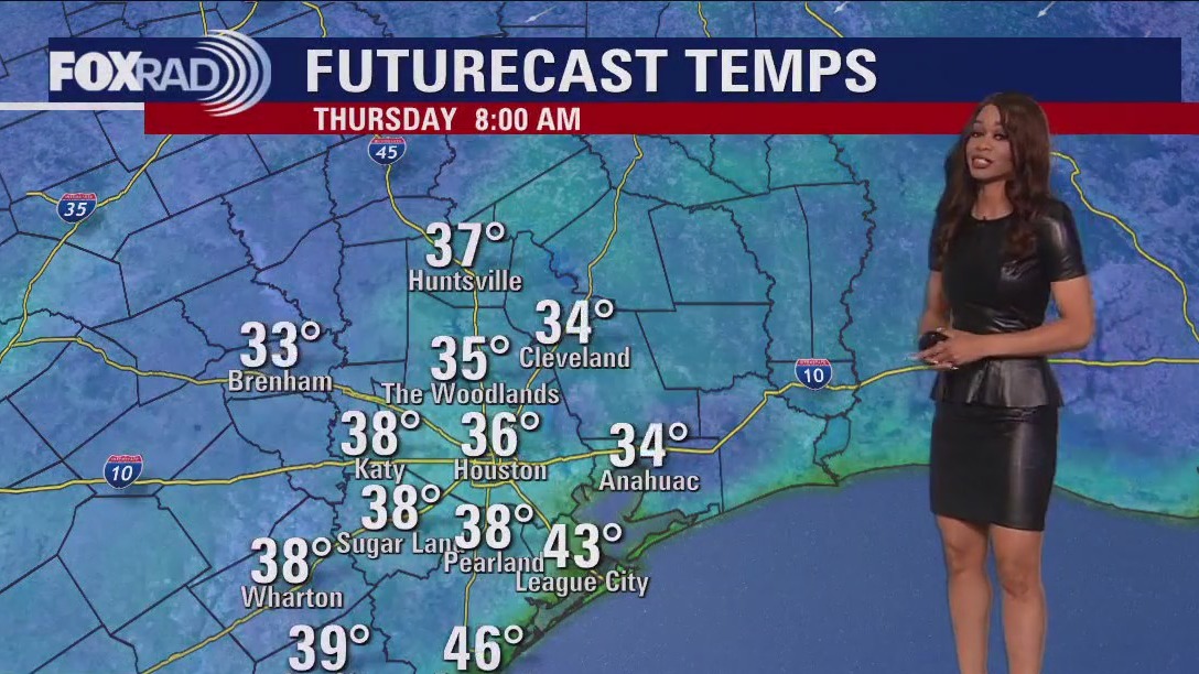
The coldest night so far this fall season is expected tonight with some areas north of Houston under a Freeze Warning. This Freeze Warning is from 1-9 AM and includes Grimes, Walker, Polk, San Jacinto & North/Central parts of Liberty counties. Temperatures are expected to fall to near 30 early Thursday morning which could cause some issues if you're not ready. So make sure to protect sensitive plants and don't forget to keep your pets and yourself warm! After a chilly Thursday morning, temperatures climb to near 70 with lots of sun Thursday afternoon. That warming trend will carry on into the weekend and next week with only a slim chance of a shower Saturday and Sunday. Also, daylight saving time ends at 2 AM Sunday so don't forget to set your clocks back one hour before you go to bed Saturday night.
The coldest night so far this fall season is expected tonight with some areas north of Houston under a Freeze Warning. This Freeze Warning is from 1-9 AM and includes Grimes, Walker, Polk, San Jacinto & North/Central parts of Liberty counties. Temperatures are expected to fall to near 30 early Thursday morning which could cause some issues if you're not ready. So make sure to protect sensitive plants and don't forget to keep your pets and yourself warm! After a chilly Thursday morning, temperatures climb to near 70 with lots of sun Thursday afternoon. That warming trend will carry on into the weekend and next week with only a slim chance of a shower Saturday and Sunday. Also, daylight saving time ends at 2 AM Sunday so don't forget to set your clocks back one hour before you go to bed Saturday night.


FOX 26 Houston Weather Forecast
The coldest night so far this fall season is expected tonight with some areas north of Houston under a Freeze Warning. This Freeze Warning is from 1-9 AM and includes Grimes, Walker, Polk, San Jacinto & North/Central parts of Liberty counties. Temperatures are expected to fall to near 30 early Thursday morning which could cause some issues if you're not ready. So make sure to protect sensitive plants and don't forget to keep your pets and yourself warm! After a chilly Thursday morning, temperatures climb to near 70 with lots of sun Thursday afternoon. That warming trend will carry on into the weekend and next week with only a slim chance of a shower Saturday and Sunday. Also, daylight saving time ends at 2 AM Sunday so don't forget to set your clocks back one hour before you go to bed Saturday night.
The coldest night so far this fall season is expected tonight with some areas north of Houston under a Freeze Warning. This Freeze Warning is from 1-9 AM and includes Grimes, Walker, Polk, San Jacinto & North/Central parts of Liberty counties. Temperatures are expected to fall to near 30 early Thursday morning which could cause some issues if you're not ready. So make sure to protect sensitive plants and don't forget to keep your pets and yourself warm! After a chilly Thursday morning, temperatures climb to near 70 with lots of sun Thursday afternoon. That warming trend will carry on into the weekend and next week with only a slim chance of a shower Saturday and Sunday. Also, daylight saving time ends at 2 AM Sunday so don't forget to set your clocks back one hour before you go to bed Saturday night.

FOX 26 Houston Weather Forecast
Get ready for more cold weather tonight. In fact, there are freeze warnings in effect for communities north of Houston. Look for sunshine and dry weather this afternoon with highs reaching the low to middle 60s, but tonight we expect lows to drop slightly below freezing for areas north of Houston. Protect your sensitive plants and make sure the pets are indoors. Once we get past tonight, we?re going to encounter a nice warming trend which should return us to the low 80s by this weekend.
Get ready for more cold weather tonight. In fact, there are freeze warnings in effect for communities north of Houston. Look for sunshine and dry weather this afternoon with highs reaching the low to middle 60s, but tonight we expect lows to drop slightly below freezing for areas north of Houston. Protect your sensitive plants and make sure the pets are indoors. Once we get past tonight, we?re going to encounter a nice warming trend which should return us to the low 80s by this weekend.

FOX 26 Houston Weather Forecast
It looks like we will have a treat instead of a trick for our weather this evening for Halloween. Look for temperatures in the low 50s with just a few clouds around as drier air builds in. So dress for the chill but don't worry about any rain. By Wednesday morning, many areas will be in the 30s! We'll rebound to the low 60s Wednesday afternoon with lots of sunshine. Another chilly morning is on the way Thursday with some frost possible, especially areas north of Houston. But the freeing temperatures are expected to remain just to our north where freeze warnings have been posted for Madisonville and Waco. But we are mild by Thursday afternoon with temperatures near 70. The weekend looks great as more warm and humid air returns. There's a slim chance for an isolated shower Saturday and Sunday. But most of the weekend will be dry and great for outdoor plans! Happy Halloween!
It looks like we will have a treat instead of a trick for our weather this evening for Halloween. Look for temperatures in the low 50s with just a few clouds around as drier air builds in. So dress for the chill but don't worry about any rain. By Wednesday morning, many areas will be in the 30s! We'll rebound to the low 60s Wednesday afternoon with lots of sunshine. Another chilly morning is on the way Thursday with some frost possible, especially areas north of Houston. But the freeing temperatures are expected to remain just to our north where freeze warnings have been posted for Madisonville and Waco. But we are mild by Thursday afternoon with temperatures near 70. The weekend looks great as more warm and humid air returns. There's a slim chance for an isolated shower Saturday and Sunday. But most of the weekend will be dry and great for outdoor plans! Happy Halloween!


Fox 26 Weather Forecast
It looks like we will have a treat instead of a trick for our weather this evening for Halloween. Look for temperatures in the low 50s with just a few clouds around as drier air builds in. So dress for the chill but don't worry about any rain. By Wednesday morning, many areas will be in the 30s! We'll rebound to the low 60s Wednesday afternoon with lots of sunshine. Another chilly morning is on the way Thursday with some frost possible, especially areas north of Houston. But the freeing temperatures are expected to remain just to our north where freeze warnings have been posted for Madisonville and Waco. But we are mild by Thursday afternoon with temperatures near 70. The weekend looks great as more warm and humid air returns. There's a slim chance for an isolated shower Saturday and Sunday. But most of the weekend will be dry and great for outdoor plans! Happy Halloween!
It looks like we will have a treat instead of a trick for our weather this evening for Halloween. Look for temperatures in the low 50s with just a few clouds around as drier air builds in. So dress for the chill but don't worry about any rain. By Wednesday morning, many areas will be in the 30s! We'll rebound to the low 60s Wednesday afternoon with lots of sunshine. Another chilly morning is on the way Thursday with some frost possible, especially areas north of Houston. But the freeing temperatures are expected to remain just to our north where freeze warnings have been posted for Madisonville and Waco. But we are mild by Thursday afternoon with temperatures near 70. The weekend looks great as more warm and humid air returns. There's a slim chance for an isolated shower Saturday and Sunday. But most of the weekend will be dry and great for outdoor plans! Happy Halloween!


FOX 26 Houston Weather Forecast
After a chilly morning with some drizzles, we?re going to gradually clear by this afternoon, staying cold though with highs below 60 in most spots. Tonight for trick-or-treating, expect temperatures to be chilly in the low 50s with a bit of a breeze. The rest of the week includes cold mornings, especially Wednesday and Thursday morning with some widespread 30s across the area, but the afternoons look fantastic especially mid 70s coming up Friday.
After a chilly morning with some drizzles, we?re going to gradually clear by this afternoon, staying cold though with highs below 60 in most spots. Tonight for trick-or-treating, expect temperatures to be chilly in the low 50s with a bit of a breeze. The rest of the week includes cold mornings, especially Wednesday and Thursday morning with some widespread 30s across the area, but the afternoons look fantastic especially mid 70s coming up Friday.


FOX 26 Houston Weather Forecast
Much colder air has pushed into SE Texas and It's been about a 40 degree temperature drop from Sunday afternoon to Monday afternoon with even colder weather on the way the next few nights! WIND ADVISORY remains in effect along the coast until 1 PM Tuesday that includes Galveston. Gusts near 40 mph are still possible. Scattered mainly light rain is expected this evening and tonight with just a few light rain showers lingering early Tuesday. Rain should end completely for the second half of Tuesday which will mean dry weather for trick-or-treating. It will be chilly tonight with widespread 40s expected. We rebound to the 50s Tuesday afternoon and low 60s Wednesday afternoon. Sunshine and a gradual warming trend is expected Wednesday through Sunday with temperatures back to around 80 by this weekend.
Much colder air has pushed into SE Texas and It's been about a 40 degree temperature drop from Sunday afternoon to Monday afternoon with even colder weather on the way the next few nights! WIND ADVISORY remains in effect along the coast until 1 PM Tuesday that includes Galveston. Gusts near 40 mph are still possible. Scattered mainly light rain is expected this evening and tonight with just a few light rain showers lingering early Tuesday. Rain should end completely for the second half of Tuesday which will mean dry weather for trick-or-treating. It will be chilly tonight with widespread 40s expected. We rebound to the 50s Tuesday afternoon and low 60s Wednesday afternoon. Sunshine and a gradual warming trend is expected Wednesday through Sunday with temperatures back to around 80 by this weekend.


Fox 26 Weather Forecast
Is it winter already? It sure will feel like it today with temps stuck below 50 along with wind and light rain. Good news - it looks dry for trick-or-treating tomorrow, but it will be chilly. Watch for a few cold mornings ahead with many areas in the 30s briefly on Tuesday and Wednesday night. Afternoons will be beautiful beginning Wednesday.
Is it winter already? It sure will feel like it today with temps stuck below 50 along with wind and light rain. Good news - it looks dry for trick-or-treating tomorrow, but it will be chilly. Watch for a few cold mornings ahead with many areas in the 30s briefly on Tuesday and Wednesday night. Afternoons will be beautiful beginning Wednesday.

FOX 26 Weather Forecast
Is it winter already? It sure will feel like it today with temps stuck below 50 along with wind and light rain. Good news - it looks dry for trick-or-treating tomorrow, but it will be chilly. Watch for a few cold mornings ahead with many areas in the 30s briefly on Tuesday and Wednesday night. Afternoons will be beautiful beginning Wednesday.
Is it winter already? It sure will feel like it today with temps stuck below 50 along with wind and light rain. Good news - it looks dry for trick-or-treating tomorrow, but it will be chilly. Watch for a few cold mornings ahead with many areas in the 30s briefly on Tuesday and Wednesday night. Afternoons will be beautiful beginning Wednesday.


FOX 26 Houston Weather Forecast
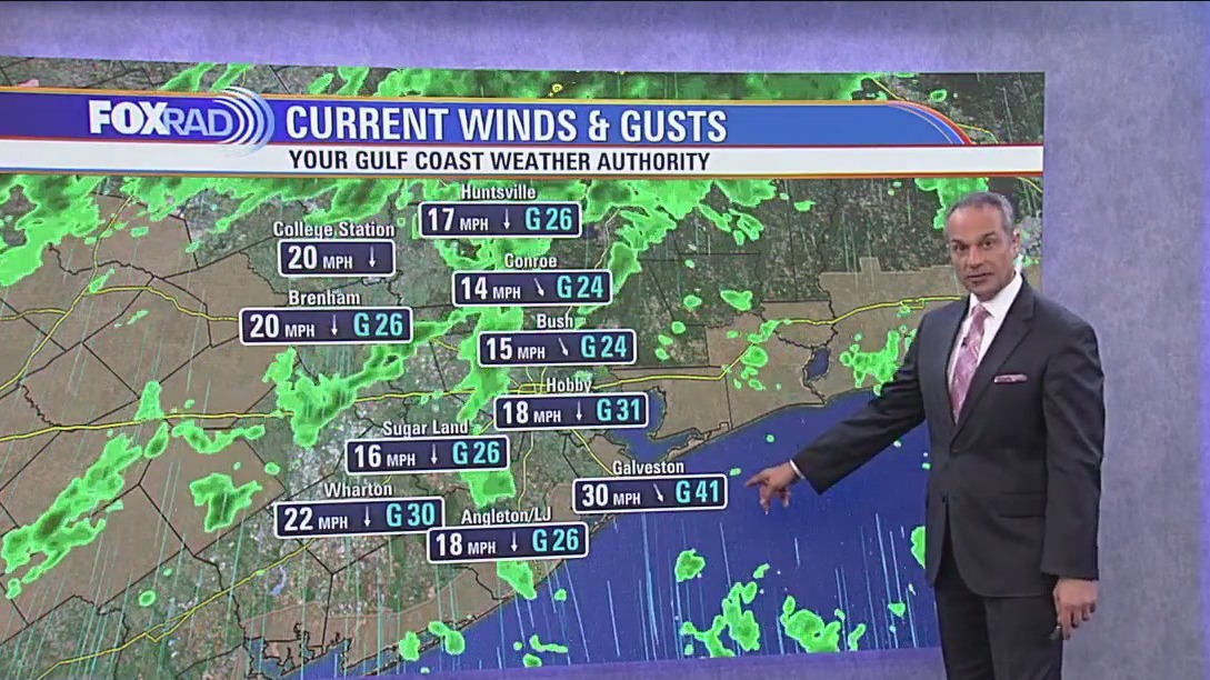
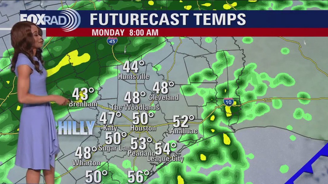
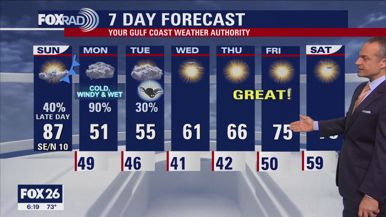
Our temperatures are in the process of flipping from feeling like summer near 90 to feeling like winter! Strong cold front is moving through SE Texas and temperatures will crash to around 50 for most areas tonight. The front is also producing some scattered showers. Rain should be mainly light with a brief heavy downpour possible. Wind will pick up behind the front and WIND ADVISORY will be in effect along the coast from 9 PM Tonight until 1 AM Tuesday. Get ready for a chilly, wet & windy Monday with high temperatures only near 50 and wind gusts near 30 mph for Houston. Showers are expected to be widespread Monday but will wind down by Tuesday morning. That means dry weather for trick-or-treating Tuesday evening. But you will need to bundle up with trick-or-treat temperatures near 50. Warmer weather gradually returns as we go through the week along with more sunshine. Have a great week!
Our temperatures are in the process of flipping from feeling like summer near 90 to feeling like winter! Strong cold front is moving through SE Texas and temperatures will crash to around 50 for most areas tonight. The front is also producing some scattered showers. Rain should be mainly light with a brief heavy downpour possible. Wind will pick up behind the front and WIND ADVISORY will be in effect along the coast from 9 PM Tonight until 1 AM Tuesday. Get ready for a chilly, wet & windy Monday with high temperatures only near 50 and wind gusts near 30 mph for Houston. Showers are expected to be widespread Monday but will wind down by Tuesday morning. That means dry weather for trick-or-treating Tuesday evening. But you will need to bundle up with trick-or-treat temperatures near 50. Warmer weather gradually returns as we go through the week along with more sunshine. Have a great week!

FOX 26 Houston Weather Update
Our temperatures are in the process of flipping from feeling like summer near 90 to feeling like winter! Strong cold front is moving through SE Texas and temperatures will crash to around 50 for most areas tonight. The front is also producing some scattered showers. Rain should be mainly light with a brief heavy downpour possible. Wind will pick up behind the front and WIND ADVISORY will be in effect along the coast from 9 PM Tonight until 1 AM Tuesday. Get ready for a chilly, wet & windy Monday with high temperatures only near 50 and wind gusts near 30 mph for Houston. Showers are expected to be widespread Monday but will wind down by Tuesday morning. That means dry weather for trick-or-treating Tuesday evening. But you will need to bundle up with trick-or-treat temperatures near 50. Warmer weather gradually returns as we go through the week along with more sunshine. Have a great week!
Our temperatures are in the process of flipping from feeling like summer near 90 to feeling like winter! Strong cold front is moving through SE Texas and temperatures will crash to around 50 for most areas tonight. The front is also producing some scattered showers. Rain should be mainly light with a brief heavy downpour possible. Wind will pick up behind the front and WIND ADVISORY will be in effect along the coast from 9 PM Tonight until 1 AM Tuesday. Get ready for a chilly, wet & windy Monday with high temperatures only near 50 and wind gusts near 30 mph for Houston. Showers are expected to be widespread Monday but will wind down by Tuesday morning. That means dry weather for trick-or-treating Tuesday evening. But you will need to bundle up with trick-or-treat temperatures near 50. Warmer weather gradually returns as we go through the week along with more sunshine. Have a great week!


JD Hurricane Gear Test: 4Patriots Solar Go-Fridge
Meteorologist John Dawson explores an innovative solution for hurricane preparedness in today's "Hurricane Gear Test." He examines a solar-powered mobile refrigerator/freezer, which could be vital for medical needs or simply add convenience during hurricane emergencies.
Meteorologist John Dawson explores an innovative solution for hurricane preparedness in today's "Hurricane Gear Test." He examines a solar-powered mobile refrigerator/freezer, which could be vital for medical needs or simply add convenience during hurricane emergencies.

FOX 26 Weather Forecast
Brace yourself for some wintry air that will arrive tonight! We should hit the mid 80s today with some upper 80s possible, then a strong front this evening will drop temperatures to near 50 overnight along with wind and showers. Now, Monday will be an ugly one with rain, wind and steady temps near 50 all day. Luckily, it looks like rain should move out for trick-or-treating on Tuesday, but it will be pretty chilly. Our weather looks beautiful for Wednesday through next weekend.
Brace yourself for some wintry air that will arrive tonight! We should hit the mid 80s today with some upper 80s possible, then a strong front this evening will drop temperatures to near 50 overnight along with wind and showers. Now, Monday will be an ugly one with rain, wind and steady temps near 50 all day. Luckily, it looks like rain should move out for trick-or-treating on Tuesday, but it will be pretty chilly. Our weather looks beautiful for Wednesday through next weekend.