


Fox 26 Houston Weather Forecast
As we start your Thursday, patchy fog is possible as you are heading to work or school. This afternoon, highs will be much warmer near 70 degrees. Skies will slowly be clearing with breezes out of the southwest. Cooler air moves in this weekend. Below freezing temperatures are expected on Saturday morning, and Sunday morning in some cities. Next week we are warming with heavy rounds of rain. The flood threat will be increasing beginning on Monday. To stay up to date on the latest weather updates, download the FOX Local app on your smart tv.
As we start your Thursday, patchy fog is possible as you are heading to work or school. This afternoon, highs will be much warmer near 70 degrees. Skies will slowly be clearing with breezes out of the southwest. Cooler air moves in this weekend. Below freezing temperatures are expected on Saturday morning, and Sunday morning in some cities. Next week we are warming with heavy rounds of rain. The flood threat will be increasing beginning on Monday. To stay up to date on the latest weather updates, download the FOX Local app on your smart tv.

FOX 26 Houston Weather Forecast
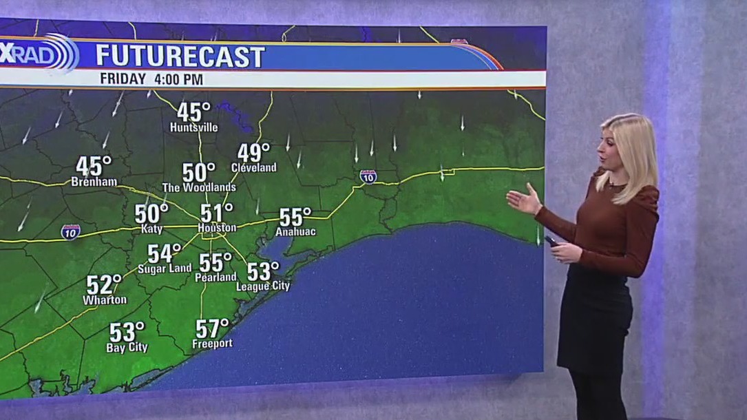
Patchy morning fog possible. Temperatures warm to the upper-60s today with southwesterly breezes.
Patchy morning fog possible. Temperatures warm to the upper-60s today with southwesterly breezes.


FOX 26 Houston Weather Forecast
As we start your Thursday, patchy fog is possible as you are heading to work or school. This afternoon, highs will be much warmer near 70 degrees. Skies will slowly be clearing with breezes out of the southwest. Cooler air moves in this weekend. Below freezing temperatures are expected on Saturday morning, and Sunday morning in some cities. Next week we are warming with heavy rounds of rain. The flood threat will be increasing beginning on Monday. To stay up to date on the latest weather updates, download the FOX Local app on your smart tv.
As we start your Thursday, patchy fog is possible as you are heading to work or school. This afternoon, highs will be much warmer near 70 degrees. Skies will slowly be clearing with breezes out of the southwest. Cooler air moves in this weekend. Below freezing temperatures are expected on Saturday morning, and Sunday morning in some cities. Next week we are warming with heavy rounds of rain. The flood threat will be increasing beginning on Monday. To stay up to date on the latest weather updates, download the FOX Local app on your smart tv.


FOX 26 Houston Weather Forecast
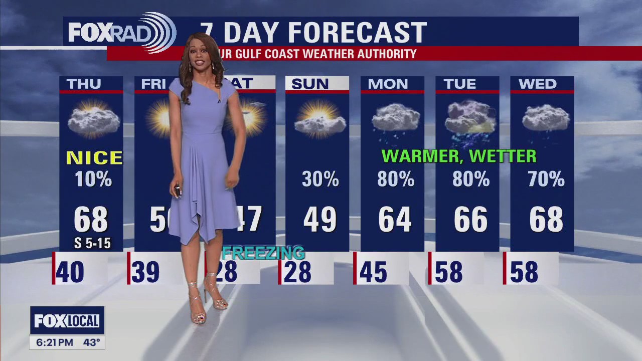
After a few nights of dealing with a "Hard Freeze", it's nice to know that temperatures should stay above freezing in Houston overnight near 40. Watch out for a few areas of fog early Thursday. It will get much warmer Thursday afternoon with high temperatures above average for a change near 70 degrees. Another cold front will bring some clouds and a 10% chance for rain Thursday followed by cooler air for the weekend. Look for another freeze Saturday and Sunday morning with temperatures dipping into the upper 20s for Houston. Then our weather pattern flips again next week with warmer temps and rounds of heavy rain set to move in on Monday. With the threat for heavy rain and an increased flood threat next week, make sure to download our app for your smart tv, Fox Local for exclusive content and frequent weather updates.
After a few nights of dealing with a "Hard Freeze", it's nice to know that temperatures should stay above freezing in Houston overnight near 40. Watch out for a few areas of fog early Thursday. It will get much warmer Thursday afternoon with high temperatures above average for a change near 70 degrees. Another cold front will bring some clouds and a 10% chance for rain Thursday followed by cooler air for the weekend. Look for another freeze Saturday and Sunday morning with temperatures dipping into the upper 20s for Houston. Then our weather pattern flips again next week with warmer temps and rounds of heavy rain set to move in on Monday. With the threat for heavy rain and an increased flood threat next week, make sure to download our app for your smart tv, Fox Local for exclusive content and frequent weather updates.

FOX 26 Houston Weather Forecast
After a few nights of dealing with a "Hard Freeze", it's nice to know that temperatures should stay above freezing in Houston overnight near 40. Watch out for a few areas of fog early Thursday. It will get much warmer Thursday afternoon with high temperatures above average for a change near 70 degrees. Another cold front will bring some clouds and a 10% chance for rain Thursday followed by cooler air for the weekend. Look for another freeze Saturday and Sunday morning with temperatures dipping into the upper 20s for Houston. Then our weather pattern flips again next week with warmer temps and rounds of heavy rain set to move in on Monday. With the threat for heavy rain and an increased flood threat next week, make sure to download our app for your smart tv, Fox Local for exclusive content and frequent weather updates.
After a few nights of dealing with a "Hard Freeze", it's nice to know that temperatures should stay above freezing in Houston overnight near 40. Watch out for a few areas of fog early Thursday. It will get much warmer Thursday afternoon with high temperatures above average for a change near 70 degrees. Another cold front will bring some clouds and a 10% chance for rain Thursday followed by cooler air for the weekend. Look for another freeze Saturday and Sunday morning with temperatures dipping into the upper 20s for Houston. Then our weather pattern flips again next week with warmer temps and rounds of heavy rain set to move in on Monday. With the threat for heavy rain and an increased flood threat next week, make sure to download our app for your smart tv, Fox Local for exclusive content and frequent weather updates.


FOX 26 Houston Weather Forecast
After a few nights of dealing with a "Hard Freeze", it's nice to know that temperatures should stay above freezing in Houston overnight near 40. Watch out for a few areas of fog early Thursday. It will get much warmer Thursday afternoon with high temperatures above average for a change near 70 degrees. Another cold front will bring some clouds and a 10% chance for rain Thursday followed by cooler air for the weekend. Look for another freeze on Saturday and Sunday morning with temperatures dipping into the upper 20s for Houston. Then our weather pattern flips again next week with warmer temps and rounds of heavy rain set to move in on Monday. With the threat of heavy rain and an increased flood threat next week, make sure to download our app for your smart TV, FOX Local for exclusive content and frequent weather updates.
After a few nights of dealing with a "Hard Freeze", it's nice to know that temperatures should stay above freezing in Houston overnight near 40. Watch out for a few areas of fog early Thursday. It will get much warmer Thursday afternoon with high temperatures above average for a change near 70 degrees. Another cold front will bring some clouds and a 10% chance for rain Thursday followed by cooler air for the weekend. Look for another freeze on Saturday and Sunday morning with temperatures dipping into the upper 20s for Houston. Then our weather pattern flips again next week with warmer temps and rounds of heavy rain set to move in on Monday. With the threat of heavy rain and an increased flood threat next week, make sure to download our app for your smart TV, FOX Local for exclusive content and frequent weather updates.


FOX 26 Houston Weather Forecast
Temperatures have begun to warm into the 40s Wednesday afternoon after a cold morning in the 30s. Clouds and a southeast breeze will hold overnight lows to well above freezing tonight and some areas could hit 70 on Thursday. Another cold front will arrive late Thursday, so we'll have a chance for some freezing mornings on Friday night and possibly Saturday night. Next week looks very rainy
Temperatures have begun to warm into the 40s Wednesday afternoon after a cold morning in the 30s. Clouds and a southeast breeze will hold overnight lows to well above freezing tonight and some areas could hit 70 on Thursday. Another cold front will arrive late Thursday, so we'll have a chance for some freezing mornings on Friday night and possibly Saturday night. Next week looks very rainy

FOX 26 Houston Weather Forecast
After another extremely cold morning, the combination of sunshine and much lighter winds will allow temperatures to finally warm into the 40s this after noon. Clouds and a southeast breeze will hold overnight lows to well above freezing tonight and some areas could hit 70 on Thursday. Another cold front will arrive late Thursday, so we'll have a chance for some freezing mornings on Friday night and possibly Saturday night. Next week looks very rainy.
After another extremely cold morning, the combination of sunshine and much lighter winds will allow temperatures to finally warm into the 40s this after noon. Clouds and a southeast breeze will hold overnight lows to well above freezing tonight and some areas could hit 70 on Thursday. Another cold front will arrive late Thursday, so we'll have a chance for some freezing mornings on Friday night and possibly Saturday night. Next week looks very rainy.


FOX 26 Houston Weather Forecast
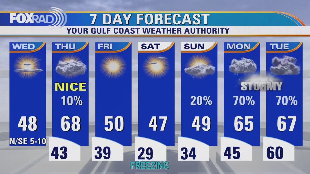
No additional freezing rain or sleet is expected as very dry air builds into SE Texas. But there are still some patches of ice on bridges, overpasses, sidewalks and other roads. Some ice could remain until Wednesday afternoon when temperatures will climb well above freezing. So continue to drive very carefully and take things slow! Also, get ready for another hard freeze tonight with a Hard Freeze Warning in place for Houston until 10 AM Wednesday. Temperatures in the teens will be likely. Wind will not be as strong tonight. However, there will still be a chance for wind chills in the teens and single digits. So another Wind Chill Advisory is in effect until 10 AM Wednesday. Wind chills could get as low as 5 above zero! So bundle up once again tonight and early Wednesday. Dramatic warming trend is set the next few days with highs near 50 Wednesday afternoon and temperatures near 70 Thursday afternoon! That warmer air will be ahead of our next system that will bring a slim shot for rain Thursday. Colder air returns for the weekend with warmer and wetter weather expected early next week.
No additional freezing rain or sleet is expected as very dry air builds into SE Texas. But there are still some patches of ice on bridges, overpasses, sidewalks and other roads. Some ice could remain until Wednesday afternoon when temperatures will climb well above freezing. So continue to drive very carefully and take things slow! Also, get ready for another hard freeze tonight with a Hard Freeze Warning in place for Houston until 10 AM Wednesday. Temperatures in the teens will be likely. Wind will not be as strong tonight. However, there will still be a chance for wind chills in the teens and single digits. So another Wind Chill Advisory is in effect until 10 AM Wednesday. Wind chills could get as low as 5 above zero! So bundle up once again tonight and early Wednesday. Dramatic warming trend is set the next few days with highs near 50 Wednesday afternoon and temperatures near 70 Thursday afternoon! That warmer air will be ahead of our next system that will bring a slim shot for rain Thursday. Colder air returns for the weekend with warmer and wetter weather expected early next week.


FOX 26 Houston Weather Forecast
No additional freezing rain or sleet is expected as very dry air builds into SE Texas. But there are still some patches of ice on bridges, overpasses, sidewalks and other roads. Some ice could remain until Wednesday afternoon when temperatures will climb well above freezing. So continue to drive very carefully and take things slow! Also, get ready for another hard freeze tonight with a Hard Freeze Warning in place for Houston until 10 AM Wednesday. Temperatures in the teens will be likely. Wind will not be as strong tonight. However, there will still be a chance for wind chills in the teens and single digits. So another Wind Chill Advisory is in effect until 10 AM Wednesday. Wind chills could get as low as 5 above zero! So bundle up once again tonight and early Wednesday. Dramatic warming trend is set the next few days with highs near 50 Wednesday afternoon and temperatures near 70 Thursday afternoon! That warmer air will be ahead of our next system that will bring a slim shot for rain Thursday. Colder air returns for the weekend with warmer and wetter weather expected early next week.
No additional freezing rain or sleet is expected as very dry air builds into SE Texas. But there are still some patches of ice on bridges, overpasses, sidewalks and other roads. Some ice could remain until Wednesday afternoon when temperatures will climb well above freezing. So continue to drive very carefully and take things slow! Also, get ready for another hard freeze tonight with a Hard Freeze Warning in place for Houston until 10 AM Wednesday. Temperatures in the teens will be likely. Wind will not be as strong tonight. However, there will still be a chance for wind chills in the teens and single digits. So another Wind Chill Advisory is in effect until 10 AM Wednesday. Wind chills could get as low as 5 above zero! So bundle up once again tonight and early Wednesday. Dramatic warming trend is set the next few days with highs near 50 Wednesday afternoon and temperatures near 70 Thursday afternoon! That warmer air will be ahead of our next system that will bring a slim shot for rain Thursday. Colder air returns for the weekend with warmer and wetter weather expected early next week.


FOX 26 Houston Weather Forecast
No additional freezing rain or sleet is expected as very dry air builds into SE Texas. But there are still some patches of ice on bridges, overpasses, sidewalks, and other roads. Some ice could remain until Wednesday afternoon when temperatures will climb well above freezing. So continue to drive very carefully and take things slow! Also, get ready for another hard freeze tonight with a Hard Freeze Warning in place for Houston until 10 a.m. Wednesday. Temperatures in the teens will be likely. The wind will not be as strong tonight. However, there will still be a chance for wind chills in the teens and single digits. So another Wind Chill Advisory is in effect until 10 a.m. Wednesday. Wind chills could get as low as 5 above zero! So bundle up once again tonight and early Wednesday. A dramatic warming trend is set for the next few days with highs near 50 Wednesday afternoon and temperatures near 70 Thursday afternoon! That warmer air will be ahead of our next system which will bring a slim shot of rain on Thursday. Colder air returns for the weekend with warmer and wetter weather expected early next week.
No additional freezing rain or sleet is expected as very dry air builds into SE Texas. But there are still some patches of ice on bridges, overpasses, sidewalks, and other roads. Some ice could remain until Wednesday afternoon when temperatures will climb well above freezing. So continue to drive very carefully and take things slow! Also, get ready for another hard freeze tonight with a Hard Freeze Warning in place for Houston until 10 a.m. Wednesday. Temperatures in the teens will be likely. The wind will not be as strong tonight. However, there will still be a chance for wind chills in the teens and single digits. So another Wind Chill Advisory is in effect until 10 a.m. Wednesday. Wind chills could get as low as 5 above zero! So bundle up once again tonight and early Wednesday. A dramatic warming trend is set for the next few days with highs near 50 Wednesday afternoon and temperatures near 70 Thursday afternoon! That warmer air will be ahead of our next system which will bring a slim shot of rain on Thursday. Colder air returns for the weekend with warmer and wetter weather expected early next week.


FOX 26 Houston Weather Forecast
No additional freezing rain or sleet is expected as very dry air builds into SE Texas. But there are still some patches of ice on bridges, overpasses, sidewalks, and other roads. Some ice could remain until Wednesday afternoon when temperatures will climb well above freezing. So continue to drive very carefully and take things slow! Also, get ready for another hard freeze tonight with a Hard Freeze Warning in place for Houston until 10 a.m. Wednesday. Temperatures in the teens will be likely. The wind will not be as strong tonight. However, there will still be a chance for wind chills in the teens and single digits. So another Wind Chill Advisory is in effect until 10 AM Wednesday. Wind chills could get as low as 5 above zero! So bundle up once again tonight and early Wednesday. A dramatic warming trend is set for the next few days with highs near 50 Wednesday afternoon and temperatures near 70 Thursday afternoon! That warmer air will be ahead of our next system which will bring a slim shot of rain on Thursday. Colder air returns for the weekend with warmer and wetter weather expected early next week.
No additional freezing rain or sleet is expected as very dry air builds into SE Texas. But there are still some patches of ice on bridges, overpasses, sidewalks, and other roads. Some ice could remain until Wednesday afternoon when temperatures will climb well above freezing. So continue to drive very carefully and take things slow! Also, get ready for another hard freeze tonight with a Hard Freeze Warning in place for Houston until 10 a.m. Wednesday. Temperatures in the teens will be likely. The wind will not be as strong tonight. However, there will still be a chance for wind chills in the teens and single digits. So another Wind Chill Advisory is in effect until 10 AM Wednesday. Wind chills could get as low as 5 above zero! So bundle up once again tonight and early Wednesday. A dramatic warming trend is set for the next few days with highs near 50 Wednesday afternoon and temperatures near 70 Thursday afternoon! That warmer air will be ahead of our next system which will bring a slim shot of rain on Thursday. Colder air returns for the weekend with warmer and wetter weather expected early next week.


FOX 26 Houston Weather Forecast
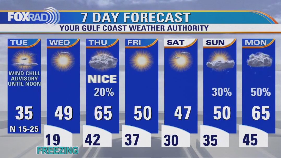
Another Hard Freeze for the Houston area tonight. Some of the area will probably see a Wind Chill Advisory as well. Temperatures rebound on Wednesday afternoon with highs for the day in the upper 40s and low 50s. Another milder front comes at the end of the week with Saturday morning seeing temperatures below freezing again.
Another Hard Freeze for the Houston area tonight. Some of the area will probably see a Wind Chill Advisory as well. Temperatures rebound on Wednesday afternoon with highs for the day in the upper 40s and low 50s. Another milder front comes at the end of the week with Saturday morning seeing temperatures below freezing again.

FOX 26 Houston Weather Forecast
Frigid temperatures this morning with a wind chill advisory in effect, then sunny and cold with highs in the mid 30s.
Frigid temperatures this morning with a wind chill advisory in effect, then sunny and cold with highs in the mid 30s.


Houston weather: Another cold night on the way
Another brutally cold night is on the way across the Houston area and road conditions in the morning will be treacherous as you head out in the morning. Here's the latest forecast from FOX 26 Meteorologist Remeisha Shade.
Another brutally cold night is on the way across the Houston area and road conditions in the morning will be treacherous as you head out in the morning. Here's the latest forecast from FOX 26 Meteorologist Remeisha Shade.

FOX 26 Houston Weather Forecast
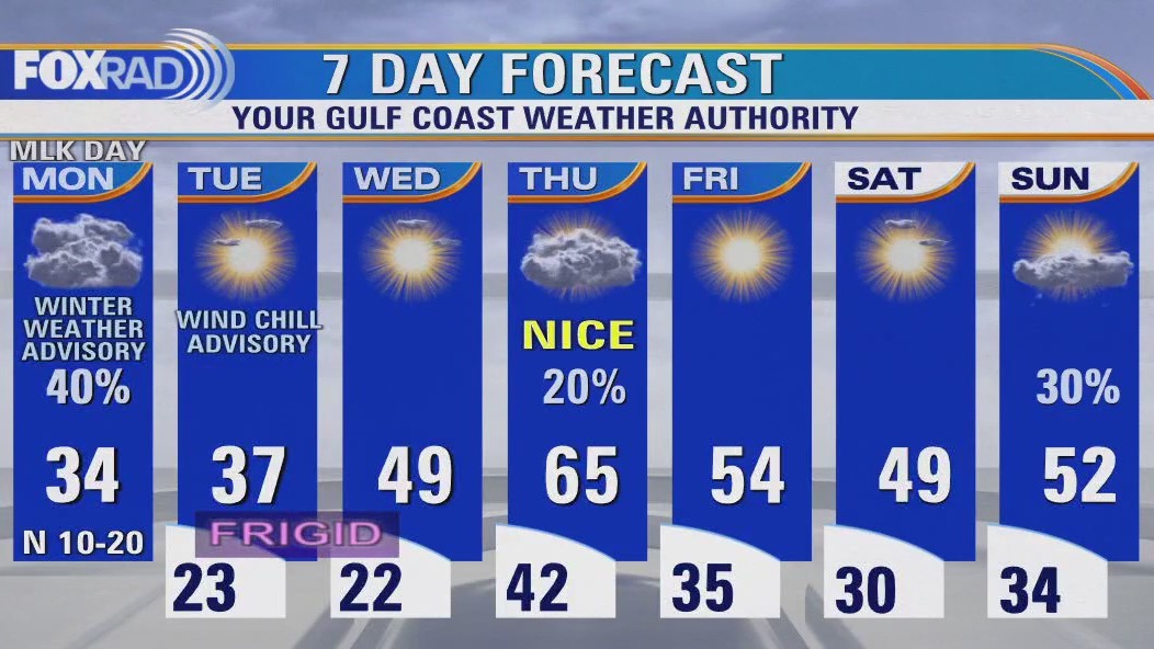
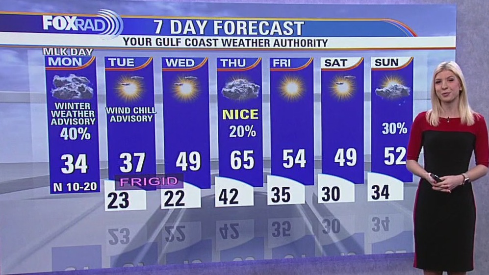
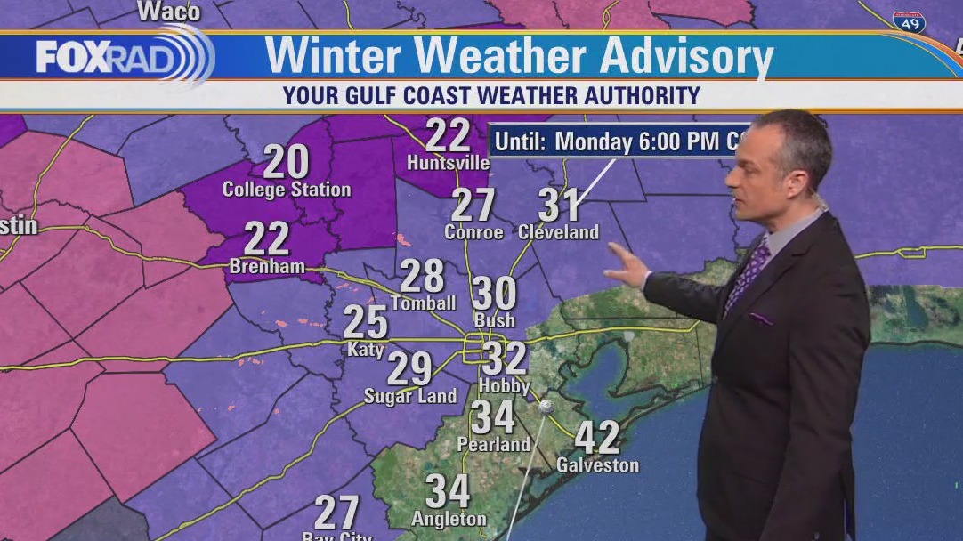
A winter weather advisory is in effect through 6 p.m. with light icing possible. Expect steady temperatures near freezing all day with wind chills in the teens. Light freezing rain or sleet in possible. A hard freeze is expected tonight with lows in the low 20s.
A winter weather advisory is in effect through 6 p.m. with light icing possible. Expect steady temperatures near freezing all day with wind chills in the teens. Light freezing rain or sleet in possible. A hard freeze is expected tonight with lows in the low 20s.

FOX 26 Houston Weather Forecast
A winter weather advisory is in effect through 6 p.m. with light icing possible. Expect steady temperatures near freezing all day with wind chills in the teens. Light freezing rain or sleet in possible. A hard freeze is expected tonight with lows in the low 20s.
A winter weather advisory is in effect through 6 p.m. with light icing possible. Expect steady temperatures near freezing all day with wind chills in the teens. Light freezing rain or sleet in possible. A hard freeze is expected tonight with lows in the low 20s.


Arctic blast rolling into Houston
The expected arctic blast, that we've been reporting on for several days, has finally moving into the area. Here's the latest arctic blast forecast.
The expected arctic blast, that we've been reporting on for several days, has finally moving into the area. Here's the latest arctic blast forecast.