


FOX 26 Houston Weather Forecast
Humidity and warmer temperatures rushing back into Southeast Texas. Wednesday should be mostly dry from rain but you'll feel the moisture in the air with "muggy" returning to the forecast for the last days of Spring Break. A stalling front brings rainy days on Friday and Saturday but not complete washouts. Look for a few stronger storms to be mixed in with the showers. A stronger cold front will push into Houston at the end of the weekend and clear out most of the rain for the start of the workweek.
Humidity and warmer temperatures rushing back into Southeast Texas. Wednesday should be mostly dry from rain but you'll feel the moisture in the air with "muggy" returning to the forecast for the last days of Spring Break. A stalling front brings rainy days on Friday and Saturday but not complete washouts. Look for a few stronger storms to be mixed in with the showers. A stronger cold front will push into Houston at the end of the weekend and clear out most of the rain for the start of the workweek.


FOX 26 Houston Weather Forecast
We have another great day for the spring breakers across Houston. If you are heading to the rodeo or the beach, you can expect warmer temperatures this afternoon with passing clouds. Highs soar to the 80s Wednesday through Friday. Rain and storm chances are also on the rise late week and into the weekend. We are monitoring our next cold front which will bring heavy rain and the chance for storms during that time. Once the cold front clears, cooler temperatures are expected to start next week.
We have another great day for the spring breakers across Houston. If you are heading to the rodeo or the beach, you can expect warmer temperatures this afternoon with passing clouds. Highs soar to the 80s Wednesday through Friday. Rain and storm chances are also on the rise late week and into the weekend. We are monitoring our next cold front which will bring heavy rain and the chance for storms during that time. Once the cold front clears, cooler temperatures are expected to start next week.


FOZ 26 Houston Weather Forecast
Spring Breakers are excited about this near perfect weather to start the week here across Southeast Texas. Tuesday will look a lot like Monday with a cool morning and pleasant afternoon. Wednesday will see the return of humidity and warmer temperatures but the rain should holdoff until late Thursday and Friday. The weekend should not be a washout but there will be some showers around the Houston area.
Spring Breakers are excited about this near perfect weather to start the week here across Southeast Texas. Tuesday will look a lot like Monday with a cool morning and pleasant afternoon. Wednesday will see the return of humidity and warmer temperatures but the rain should holdoff until late Thursday and Friday. The weekend should not be a washout but there will be some showers around the Houston area.


FOX 26 Houston Weather Forecast
Spring Breakers are excited about this near perfect weather to start the week here across Southeast Texas. Tuesday will look a lot like Monday with a cool morning and pleasant afternoon. Wednesday will see the return of humidity and warmer temperatures but the rain should holdoff until late Thursday and Friday. The weekend should not be a washout but there will be some showers around the Houston area.
Spring Breakers are excited about this near perfect weather to start the week here across Southeast Texas. Tuesday will look a lot like Monday with a cool morning and pleasant afternoon. Wednesday will see the return of humidity and warmer temperatures but the rain should holdoff until late Thursday and Friday. The weekend should not be a washout but there will be some showers around the Houston area.


FOX 26 Houston Weather Forecast
It is a great start to spring break across Houston and Southeast Texas. Highs Monday and Tuesday remain in the 70s with a few passing clouds. Temperatures soar to the 80s midweek before rain chances rise at the end of the week. Download the free FOX Local app on your smart tv for the latest weather updates.
It is a great start to spring break across Houston and Southeast Texas. Highs Monday and Tuesday remain in the 70s with a few passing clouds. Temperatures soar to the 80s midweek before rain chances rise at the end of the week. Download the free FOX Local app on your smart tv for the latest weather updates.


FOX 26 Houston Weather Forecast
Monday and Tuesday are spectacular across Southeast Texas and a perfect way to start Spring Break. Look for a gradual warming trend in Houston as we move through the week. Rain chances return for the end of the week. Things will remain unsettled for next weekend but it won't be a washout. There should be enough time between showers to enjoy the comfortable temperatures for your outdoor activities
Monday and Tuesday are spectacular across Southeast Texas and a perfect way to start Spring Break. Look for a gradual warming trend in Houston as we move through the week. Rain chances return for the end of the week. Things will remain unsettled for next weekend but it won't be a washout. There should be enough time between showers to enjoy the comfortable temperatures for your outdoor activities


FOX 26 Houston Weather Forecast
Here's the latest weather forecast from FOX 26 Meteorologist John Dawson.
Here's the latest weather forecast from FOX 26 Meteorologist John Dawson.


FOX 26 Houston Weather Forecast
Sunday morning should be the chilliest morning for those celebrating Spring Break. Monday and Tuesday will be perfect for any outdoor activities around the Houston area. We gradually heat up starting on Wednesday and scattered showers and storms also return to the forecast for the end of the week.
Sunday morning should be the chilliest morning for those celebrating Spring Break. Monday and Tuesday will be perfect for any outdoor activities around the Houston area. We gradually heat up starting on Wednesday and scattered showers and storms also return to the forecast for the end of the week.


FOX 26 Houston Weather Forecast
Threat for any severe weather has shifted to our east as cold front rolls in this evening. Look for drier air to build in just in time for the weekend with wind getting stronger out of the north for Saturday. Gusts will be near 30 mph at times by Saturday morning. Otherwise, plan on cooler rodeo, park and beach weather this weekend with afternoon high temperatures in the upper 60s and over night lows in the 40s. That means jackets may be needed for your weekend nighttime plans. We gradually heat up next week with scattered showers and storms returns returning Thursday and Friday. Have a great weekend!
Threat for any severe weather has shifted to our east as cold front rolls in this evening. Look for drier air to build in just in time for the weekend with wind getting stronger out of the north for Saturday. Gusts will be near 30 mph at times by Saturday morning. Otherwise, plan on cooler rodeo, park and beach weather this weekend with afternoon high temperatures in the upper 60s and over night lows in the 40s. That means jackets may be needed for your weekend nighttime plans. We gradually heat up next week with scattered showers and storms returns returning Thursday and Friday. Have a great weekend!


FOX 26 Houston Weather Forecast
Threat for any severe weather has shifted to our east as cold front rolls in this evening. Look for drier air to build in just in time for the weekend with wind getting stronger out of the north for Saturday. Gusts will be near 30 mph at times by Saturday morning. Otherwise, plan on cooler rodeo, park, and beach weather this weekend with afternoon high temperatures in the upper 60s and overnight lows in the 40s. That means jackets may be needed for your weekend nighttime plans. We gradually heat up next week with scattered showers and storms returns returning Thursday and Friday. Have a great weekend!
Threat for any severe weather has shifted to our east as cold front rolls in this evening. Look for drier air to build in just in time for the weekend with wind getting stronger out of the north for Saturday. Gusts will be near 30 mph at times by Saturday morning. Otherwise, plan on cooler rodeo, park, and beach weather this weekend with afternoon high temperatures in the upper 60s and overnight lows in the 40s. That means jackets may be needed for your weekend nighttime plans. We gradually heat up next week with scattered showers and storms returns returning Thursday and Friday. Have a great weekend!


FOX 26 Houston Weather Forecast
We?re watching a chance for some isolated to scattered strong thunderstorms mainly north of Houston taking us through midday or early afternoon. So today is a FOX 26 Storm Alert Day north of Houston. Otherwise, look for some scattered showers to possibly affect your rodeo plans for the day today with warm temperatures in the low 80s. The weekend starts out with breezy and cooler conditions for Saturday followed by some brisk mornings and beautiful sunny afternoons for much of spring break. Enjoy.
We?re watching a chance for some isolated to scattered strong thunderstorms mainly north of Houston taking us through midday or early afternoon. So today is a FOX 26 Storm Alert Day north of Houston. Otherwise, look for some scattered showers to possibly affect your rodeo plans for the day today with warm temperatures in the low 80s. The weekend starts out with breezy and cooler conditions for Saturday followed by some brisk mornings and beautiful sunny afternoons for much of spring break. Enjoy.


FOX 26 Houston Weather Forecast
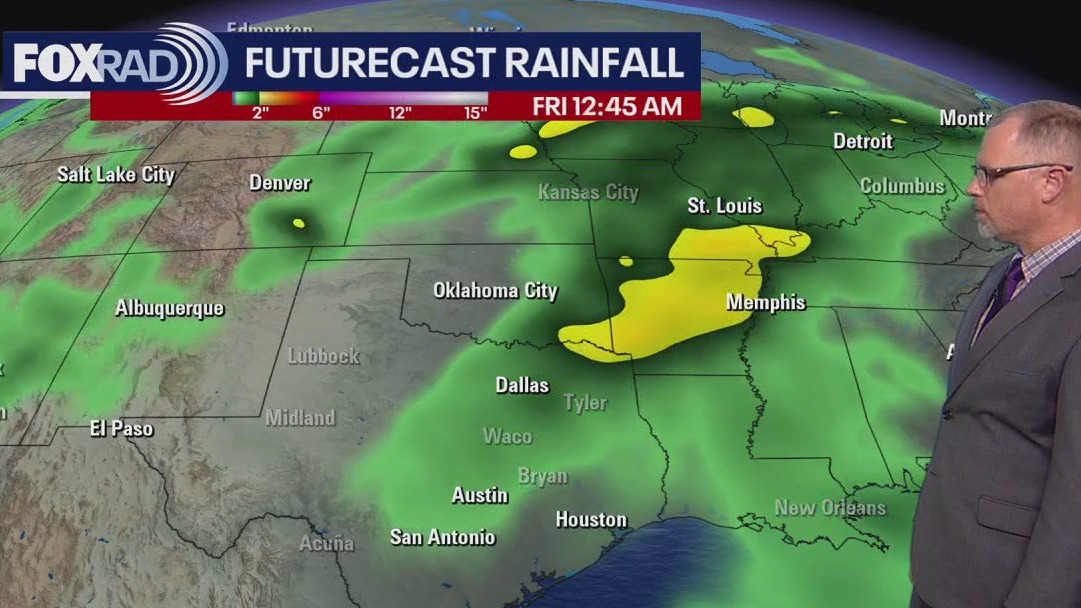
Look for a few showers possible through tonight with mild temperatures overnight near 70. Friday is a FOX 26 Storm Alert Day with the risk for isolated strong to severe storms. The severe threat has decreased a bit with the highest risk staying just north of Houston. One or two storms could still contain brief strong winds near 60 mph, hail, and heavy downpours. Main window for these storms will be from around 7 AM until 3 PM Friday. Temperatures should climb to the low 80s Friday afternoon ahead of the front. Showers and storms will roll out Friday evening as breezy north winds bring in cooler and drier air. That means a beautiful weekend with pleasant afternoons and cool nights. Saturday will be breezy but your weekend weather will feature lots of sunshine. Enjoy!
Look for a few showers possible through tonight with mild temperatures overnight near 70. Friday is a FOX 26 Storm Alert Day with the risk for isolated strong to severe storms. The severe threat has decreased a bit with the highest risk staying just north of Houston. One or two storms could still contain brief strong winds near 60 mph, hail, and heavy downpours. Main window for these storms will be from around 7 AM until 3 PM Friday. Temperatures should climb to the low 80s Friday afternoon ahead of the front. Showers and storms will roll out Friday evening as breezy north winds bring in cooler and drier air. That means a beautiful weekend with pleasant afternoons and cool nights. Saturday will be breezy but your weekend weather will feature lots of sunshine. Enjoy!


FOX 26 Houston Weather Forecast
Look for a few showers possible through tonight with mild temperatures overnight near 70. Friday is a FOX 26 Storm Alert Day with the risk for isolated strong to severe storms. The severe threat has decreased a bit with the highest risk staying just north of Houston. One or two storms could still contain brief strong winds near 60 mph, hail, and heavy downpours. The main window for these storms will be from around 7 AM until 3 PM Friday. Temperatures should climb to the low 80s Friday afternoon ahead of the front. Showers and storms will roll out Friday evening as breezy north winds bring in cooler and drier air. That means a beautiful weekend with pleasant afternoons and cool nights. Saturday will be breezy but your weekend weather will feature lots of sunshine. Enjoy!
Look for a few showers possible through tonight with mild temperatures overnight near 70. Friday is a FOX 26 Storm Alert Day with the risk for isolated strong to severe storms. The severe threat has decreased a bit with the highest risk staying just north of Houston. One or two storms could still contain brief strong winds near 60 mph, hail, and heavy downpours. The main window for these storms will be from around 7 AM until 3 PM Friday. Temperatures should climb to the low 80s Friday afternoon ahead of the front. Showers and storms will roll out Friday evening as breezy north winds bring in cooler and drier air. That means a beautiful weekend with pleasant afternoons and cool nights. Saturday will be breezy but your weekend weather will feature lots of sunshine. Enjoy!


FOX 26 Houston Weather Forecast
As usual, we have many weather changes ahead. First, today will bring increasing clouds, breezy southeast winds and high tree pollen levels. There may be a few late day showers today, but rain chances increase greatly tomorrow with a cold front bringing a chance for strong thunderstorms. A few could bring hail or high winds, but they should be isolated. Great news for the weekend and beyond as the start to spring break looks amazing - cooler and drier.
As usual, we have many weather changes ahead. First, today will bring increasing clouds, breezy southeast winds and high tree pollen levels. There may be a few late day showers today, but rain chances increase greatly tomorrow with a cold front bringing a chance for strong thunderstorms. A few could bring hail or high winds, but they should be isolated. Great news for the weekend and beyond as the start to spring break looks amazing - cooler and drier.


FOX 26 Houston Weather Forecast
It is another steamy day across the Houston area with unseasonably warm temperatures. Temperatures will remain warm near 80 for the next few afternoons. Look for some thick fog early Thursday and a few showers during the day. A few storms may clip our northern counties Thursday evening, but severe weather is not expected. However, Friday is now a FOX 26 Storm Alert Day with the threat for severe storms increasing. Best chance will be Friday morning through Friday afternoon with the highest risk north of Houston. There's a 1 of 5 severe storm risk for Houston and a 2 of 5 risk north including Huntsville & Livingston. Main threats are strong winds and large hail along with some heavy downpours. Cold front will move through by evening ushering in some cooler and drier air for the weekend. It will also be a nice start to spring break next week with pleasant temperatures and lots of sunshine.
It is another steamy day across the Houston area with unseasonably warm temperatures. Temperatures will remain warm near 80 for the next few afternoons. Look for some thick fog early Thursday and a few showers during the day. A few storms may clip our northern counties Thursday evening, but severe weather is not expected. However, Friday is now a FOX 26 Storm Alert Day with the threat for severe storms increasing. Best chance will be Friday morning through Friday afternoon with the highest risk north of Houston. There's a 1 of 5 severe storm risk for Houston and a 2 of 5 risk north including Huntsville & Livingston. Main threats are strong winds and large hail along with some heavy downpours. Cold front will move through by evening ushering in some cooler and drier air for the weekend. It will also be a nice start to spring break next week with pleasant temperatures and lots of sunshine.


FOX 26 Houston Weather Forecast
Temperatures in Houston soared into the upper 80s yesterday which, as expected, broke records. Today's highs should be just shy of record highs with changes on the way. Storms are likely on Friday along a front and some could be strong. Cooler air will move in for the weekend with beautiful afternoons and brisk mornings.
Temperatures in Houston soared into the upper 80s yesterday which, as expected, broke records. Today's highs should be just shy of record highs with changes on the way. Storms are likely on Friday along a front and some could be strong. Cooler air will move in for the weekend with beautiful afternoons and brisk mornings.


FOX 26 Houston Weather Forecast
Record high temperatures were shattered today across Houston with both Bush and Hobby Airports reaching a whopping 89 degrees! Expect more fog overnight and near record heat Wednesday with temperatures into the middle 80s. We should climb to near 80 on Thursday and Friday before pleasant afternoons and cool nights return for the upcoming weekend. Isolated showers are possible the next few days with a bettered chance for more widespread showers and storms on Friday. The weekend should feature more sunshine and temperatures more comfortable for early March. Remember this weekend brings the beginning of daylight saving time, so the clock goes ahead by one hour Saturday night.
Record high temperatures were shattered today across Houston with both Bush and Hobby Airports reaching a whopping 89 degrees! Expect more fog overnight and near record heat Wednesday with temperatures into the middle 80s. We should climb to near 80 on Thursday and Friday before pleasant afternoons and cool nights return for the upcoming weekend. Isolated showers are possible the next few days with a bettered chance for more widespread showers and storms on Friday. The weekend should feature more sunshine and temperatures more comfortable for early March. Remember this weekend brings the beginning of daylight saving time, so the clock goes ahead by one hour Saturday night.