

Houston weather: Tornado watch, severe thunderstorms Saturday evening
HOUSTON - Valentine's Day plans might have to be altered as a line of severe storms are rolling in this evening bringing heavy rain.
Tornado watch canceled | 8 p.m.
Around 8 p.m., the tornado watch was canceled for much of the Greater Houston Area. The watch remained in place until 9 p.m. for the counties of Chambers and Galveston.
The counties released from the watch were Brazoria, Harris, Liberty, Montgomery, Polk, Wharton, Fort Bend, Matagorda and San Jacinto.
The Galveston area also began to clear up around this time, viewers reported.
Weather damage was reported in the Pearland area, as well as in Montgomery County.
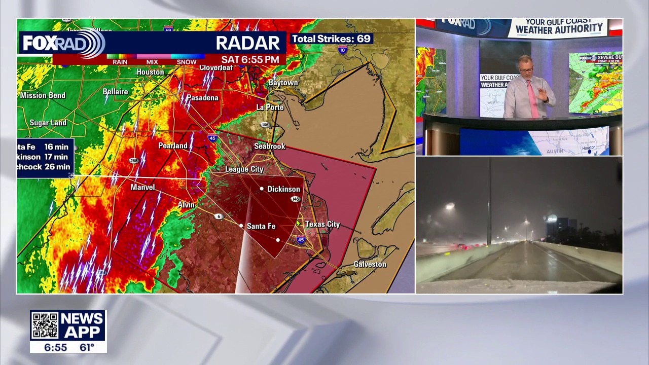
Tornado warning | 7 p.m.
A tornado warning was issued for parts of the counties of Brazoria, Harris and Galveston from 6:50 p.m. to 7:15 p.m.
The NWE said around 6:50 p.m. severe thunderstorms capable of producing both tornadoes and extensive straight line wind damage were located along a line extending from near South Belt and Ellington to six miles northeast of Bonney, moving east at 40 mph.
Two particular areas of concern were listed near Pearland and Rosharon.
This tornado warning replaces the severe thunderstorm warning issued for the same area.
Tornado warning issued for parts of Greater Houston
A tornado warning was issued Saturday evening for parts of the Greater Houston Area. Meteorologist John Dawson tracked this storm.
Tornado watch
A tornado watch has been issued for several counties in the Houston-area.
The National Weather Service says the following counties are under a tornado watch until 9 p.m.: Angelina, Austin, Brazoria, Chambers, Cherokee, Colorado, Fort Bend, Galveston, Gregg, Grimes, Hardin, Harris, Harrison, Houston, Jackson, Jasper, Jefferson, Liberty, Marion, Matagorda, Montgomery, Nacogdoches, Newton, Orange, Panola, Polk, Rusk, Sabine, San Augustine, San Jacinto, Shelby, Smith, Trinity, Tyler, Upshur, Walker, Waller, Washington, and Wharton.

Severe thunderstorm warning
The National Weather Service has been issuing severe thunderstorm warnings for several counties until various points of the evening.
A warning is in place for Northeastern Wharton County, Fort Bend County, Northwestern Brazoria County, Southwestern Liberty County, Southeastern Waller County, and Harris County until 6:45 p.m.
Wind gusts of 60 mph have been reported, possibly causing damage to roofs, siding, and trees.
FOX 26 Storm Alert Saturday evening
Houston weather: Severe storms to roll in Saturday evening
Valentine's Day plans might have to be moved to home as a line of severe storms are going to roll in this evening. Allison Gargaro shares a timeline as to when you should expect the heavy rain.
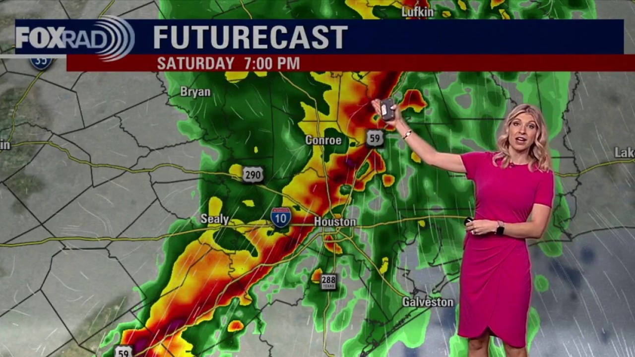
Strong to severe storms and heavy rain are likely Saturday evening as a strong system rolls into southeast Texas. Houston has been placed under a higher 2 out of 5 risk for severe storms bringing the potential for heavy rain, damaging wind gusts, small hail and even a tornado or two.

The main window for the strongest storms appears to begin around 5 p.m. northwest of Houston and sweep into the Gulf by 10 p.m.

Impacts on Valentine's and Mardi Gras plans
There will be a high chance of showers much of Saturday midday for Mardi Gras in Galveston and Valentine's plans. The threat of storms increases on Saturday night, between 5 p.m. to 8 p.m. for Houston and 7 p.m. to 10 p.m. in Galveston. Mardi Gras parades, concerts and parties could be impacted.

So plan on delays and make sure to have a way to get alerts in case you need to get inside quickly.
Crisp and clear afterward

Behind the front, cooler and much drier air settles in. Expect crisp mornings and clear, pleasant afternoons beginning Sunday and carrying into early next week — a refreshing return to more comfortable conditions. But plan on the more intense heat returning as we climb to the mid 80s by Thursday afternoon.
The Source: Your Gulf Coast Weather Authority